
さて先日探訪していた「襟裳岬」について、わたしはまったく知らずに人生を過ごしていたことに突き当たっていました。それは、この襟裳岬の東側、百人浜と言われる地域がかつて人間たちによって自然林が破壊され伐採が進んだ結果、砂漠化してしまっていたこと。
そしてその砂漠化から国の「森林再生事業」が行われて、現在海岸部でのコンブ漁が復元していること。「えりも町」のHPには以下の記述。(要旨)
〜百人浜緑化事業 えりも岬はかつて、カシワやミズナラ・シラカバなど広葉樹の原生林でした。しかし明治以降、燃料としての伐採や、牛・馬・綿羊の放牧などで原生林は切り開かれ、えりも岬特有の強風にさらされ、大地は砂漠化してしまいました。砂漠からは強風によって赤土が舞い上がり、海上10キロメートル沖合いにも達し沿岸の海は黄色く濁りました。海藻類は根腐れをおこして採れなくなり、回遊魚や沿岸の魚も減少。そんな状況を脱するため昭和28年浦河営林署「えりも治山事業所」が開設、本格的なえりも岬緑化事業がスタート。50年近く経った現在、クロマツの林は、豊かに成長してきました。植林の成果が上がるとともに、海には回遊魚が戻り、コンブ海藻類も採れるようになりました。今後は、クロマツ以外の元々この土地に生えていた種類の木々を植え、植林前の豊かな植生へと戻していくことが課題となっています。〜
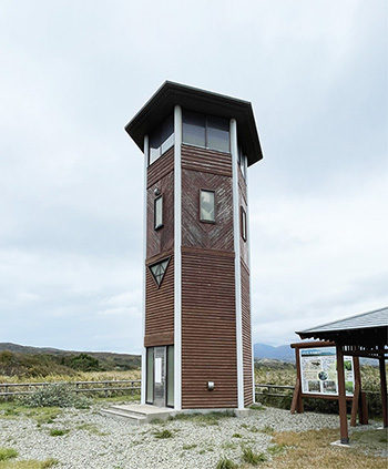
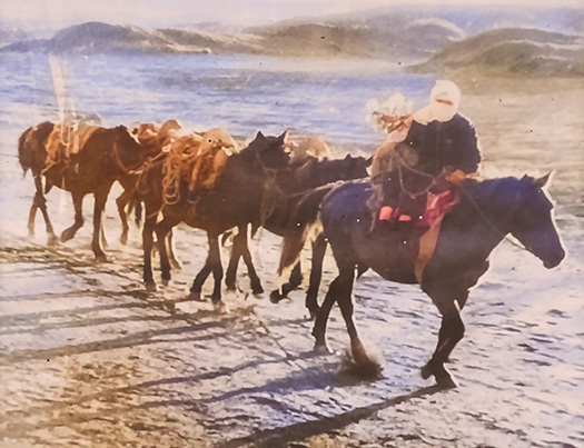
こうした様子をこちらの百人浜展望台(百人浜緑化事業観察塔)で学習させていただいた。上の写真はそのなかでも「砂漠化」の様子の表現としてわかりやすかったので、展示から撮影してみたもの。原写真は昭和28年撮影ということでモノクロ写真でしたが、AI処理ででカラー化させてみた。
その写真をさらに「動画化」させてみたのが、以下の動画。
うまくこのブログで動画再生できるのかどうか、ちょっと実験してみた次第。わたしのMac環境では問題ないのですが、いかがかと思っています。どんどんAI活用がわたしのような高齢世代でも現実化してきているので、いろいろ新しいチャレンジも可能になってきますね。大いに期待したい。
●お知らせ
拙書「作家と住空間」幻冬舎から電子書籍で発刊
お求めはAmazonで。
https://amzn.asia/d/eUiv9yO
English version⬇
Erimo Cape and Hyakunin Beach: Desertification and Forest Restoration ~ Reviving Kelp Fishing
Photographs documenting the desertification of Erimo Cape and Hyakunin Beach 72 years ago in 1953. These monochrome images have been colorized and further transformed into video. AI applications are also being explored.
Recently, while exploring Cape Erimo, I realized I had lived my entire life completely unaware of something. It was that the eastern side of this cape, an area called Hyakunin Beach, had once been devastated by human activity. Natural forests were destroyed and logging progressed, ultimately leading to desertification.
Then, as part of the national “Forest Restoration Project,” efforts were made to combat this desertification, and now kelp fishing has been restored along the coast. The Erimo Town website states the following (summary):
~ Hyakunin Beach Greening Project Erimo Cape was once covered in virgin broadleaf forests of oak, Japanese white oak, and birch. However, after the Meiji era, logging for fuel and grazing by cattle, horses, and sheep cleared the virgin forests. Exposed to Erimo Cape’s characteristic strong winds, the land became desertified. Strong winds carried red soil from the desertified land, reaching as far as 10 kilometers offshore and turning the coastal waters yellow and murky. Seaweed suffered root rot and could no longer be harvested, while migratory fish and coastal fish populations declined. To overcome this situation, the Urakawa Forest Management Office established the “Erimo Forest Conservation Office” in 1953, marking the start of the full-scale Erimo Cape Greening Project. Nearly 50 years later, the black pine forests have grown luxuriantly. As the results of the afforestation became apparent, migratory fish returned to the sea, and kelp and other seaweeds became harvestable again. The challenge now is to plant species of trees native to this land, other than black pine, and restore the rich vegetation that existed before the afforestation.
I learned about these conditions at the Hyakunin Beach Observation Tower (Hyakunin Beach Greening Project Observation Tower). The photo above was taken from the exhibition because it clearly depicted the “desertification” aspect. The original photo was taken in 1953 and was monochrome, but I colorized it using AI processing.
The video below shows that photo converted into a moving image.
I decided to experiment a bit to see if videos play smoothly on this blog. It works fine on my Mac, but I’m curious about how it looks elsewhere. As AI becomes increasingly accessible even for older generations like myself, it opens up all sorts of new challenges. I’m really looking forward to it.
●Notice
My book “Writers and Living Spaces” is now available as an e-book from Gentosha.
Available on Amazon.
共有:

Posted on 10月 26th, 2025 by 三木 奎吾
Filed under: 未分類


コメントを投稿
「※誹謗中傷や、悪意のある書き込み、営利目的などのコメントを防ぐために、投稿された全てのコメントは一時的に保留されますのでご了承ください。」
You must be logged in to post a comment.