

きのうから仕事開始で本日はさっそく出張外出日程。ですがブログは絶対に更新するぞ、という意気込みで書き続けたいと思います。最近、認知症の疑いと言われた方のお話しを聞いたのですが、とくに地理的な感覚が衰えて、あたらしい住所・場所に到達することがきわめて困難になるのだと。
へぇ〜と驚かされた。このブログでご紹介している全国各地の探訪には当然、常にあたらしい目的地を設定してカーナビを操作して向かうというのがわたしの常態。それに伴って当然、地理認識は錬磨されざるを得ない。方向感覚・距離感の複合された認識能力が常に活発に働らかされる。
わたしの場合、こうした新規探訪欲求が強く「なんでもみてやろう」みたいな好奇心のかたまり(笑)。その方のお話しを聞き、いても立ってもいられず、またあちこち探訪せねば、と意を強くした次第。その動機として日々のブログ記述はたいへん役立っているので、健康維持にも最重要でしょうね。
で、本日は行き着くまでにまれに見る苦労をした「徐福の宮」探訪篇。
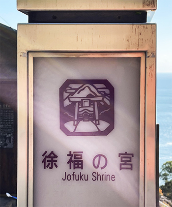
上の写真はやや高台に位置する熊野市波田須町の国道311号線から「徐福の宮」の目印である一本木を見下ろしたショット。看板も設置してあった。
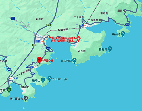
ところが、その看板付近にある「道路」らしきものは、国道から急角度で下って、すぐに曲がりくねるという超難路。北海道の常識感覚ではありえないほどの1車線道路で、しかも路側の石もないという、はじめて訪れた人間の進入を拒むような道でありました。何度見返してみても「これはムリ」。
詳細地図がこちらですが、徐福の宮の左上ポイントになります。一応,道路にはなっているけれど、細い道を急降下してしかも左折する様子がお分かりいただけるでしょうか。
「これはなにかの間違いだろう、ありえない」と考えたのですが、そういう間違いの標識をわざわざ国道沿いに設置することはないでしょう。途方に暮れ半分は探訪を諦めて、通り過ごそうかと思ってその場所を離れて、地図上で左手方向にクルマを移動させた。そうしたら運良く地元の方と遭遇。はじめての訪問者にとってそれなりにわかりやすい道順をお聞かせいただいた。「まぁ、だいたい道なりに行けばなんとか」みたいなお話しでした。
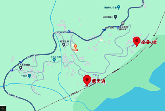
で、目的地からはいったん遠く離れ、地図左端のポイントからうねうねと描かれたクルマ1台がやっとの坂道を下っていった。北海道人として本州地域の街路の狭さはイタいほどに知っているので、クルマは軽もしくはコンパクトカー一択。このときも幸い、軽だったのでなんとかハンドルを操作できた次第。
それにしても先ほどの案内道とは違って急角度ではないけれど、1台やっとでしかも路側石もない坂道・・・。それも曲がりくねっているので、位置感覚はまったく摑みにくい。カーナビもあまりの難路ぶりで案内機能不全に陥っていた。というか、見るゆとりはとてもない。
引き返すことも困難なこの状況の時に地元の「郵便配達員」の方と遭遇。先ほどの方と同じお答えでしたが、こちらとしてはそこそこ力強いアドバイスと勇気が出ました、感謝。
最後は「ここにしか駐車できない」と言われた駐車場を発見できてなんとかクルマを停め、目印の一本木をめがけて歩いて、ようやく現地に到達できた。
自分の地理認識能力が究極的に鍛えられる困難に耐えた、と言えるでしょうか。まだ認知機能低下はなく挑戦心は元気、若い!(笑)。
ふ〜、疲れた。以降の現認報告はあしたへ。
English version⬇
Xufuku no Miya, Hadano-cho, Kumano City, Mie Prefecture: A Journey to Kumano and the Myth of the Imperial Lineage-9
Aging decreases cognitive function. Geographical recognition is the most prominent factor in dementia. From walking on a mountain road in Tategasaki to a narrow slope that is difficult to drive on. …
I started work yesterday, and today I will be out of town on a business trip. However, I am determined to keep writing this blog. Recently, I heard a story about a person who was suspected to have dementia, especially geographical sense is deteriorated and it becomes extremely difficult to reach a new address or place.
I was surprised. Whenever I visit the various places in Japan that I introduce in this blog, I always set a new destination and use the car navigation system to get there. This naturally requires me to improve my geographical awareness. My combined sense of direction and distance is always actively exercised.
In my case, I have a strong desire to explore new places, and I have a mass of curiosity like “I’ll try anything” (laugh). Hearing this person’s story, I couldn’t stand still, and I felt strongly that I had to explore again. My daily blog entries have been very helpful in motivating me to do so, which is probably the most important thing for me to do to maintain my health.
Today, I would like to introduce you to “Xufu’s Palace,” which was one of the most difficult places I ever visited before I arrived there.
The photo above is a view looking down on Ippongi, the landmark of “Xufuku no Miya,” from Route 311 in Hadasu-cho, Kumano City, which is located on a slightly elevated plateau. A signboard was also in place.
However, what appeared to be a “road” near the sign, however, was an extremely difficult road that descended at a steep angle from the national highway and then quickly curved around. It was a one-lane road, which is impossible in the common sense of Hokkaido, and there were no roadside stones, so it was the kind of road that first-time visitors would refuse to enter. No matter how many times I looked back at it, I thought, “This is impossible.
The detailed map is shown here, at the upper left point of the Xufu Palace. You can see that the road is a road, but it is a narrow road with a sharp drop off and a left turn.
I thought to myself, “This must be some kind of mistake, it can’t be,” but I would not have bothered to place such a wrong sign along the national road. At a loss, I gave up halfway and moved my car to the left on the map, thinking that I would pass by the place. As luck would have it, I ran into a local. He gave me directions that were reasonably easy to follow for a first-time visitor. He said, “Well, if you follow the road, you should be able to make it.
Once far from our destination, we started from the point on the left edge of the map and headed down a winding road that was barely enough to accommodate one car. As a person from Hokkaido, I know how narrow the streets are in the Honshu area, so I had to choose a light or compact car. Fortunately, the car was light, so I was able to maneuver the steering wheel.
Unlike the previous guideway, the slope was not steep, but it could barely accommodate one car, and there were no roadside stones. It was also winding, so it was difficult to get a sense of where we were. The car navigation system was also not functioning properly due to the difficulty of the road. In fact, there was no time to look at it.
It was at this point that we encountered a local “mailman,” who gave us the same answer as the previous person. He gave us the same answer as the previous person, but he was able to give us some powerful advice there.
Finally, we managed to find a parking lot where we were told that we could only park here, parked our car, and walked toward the landmark Ippongi tree to finally reach the site.
I guess you could say that I endured a real-life difficulty that ultimately trained my geographical awareness. I am still young.
I am tired. I’ll report on the next day.
共有:

Posted on 1月 10th, 2024 by 三木 奎吾
Filed under: 日本社会・文化研究


コメントを投稿
「※誹謗中傷や、悪意のある書き込み、営利目的などのコメントを防ぐために、投稿された全てのコメントは一時的に保留されますのでご了承ください。」
You must be logged in to post a comment.