
世界での人間の集住「ムラ」初源期の痕跡はユダヤ、パレスチナといった中東地域の町・エリコの名が挙げられる。以下Wiki記述要旨抜粋。
〜初期は小規模な定住集落で時代区分上は新石器時代にあたる。死海の北西部にあり古代オリエントの中でも古い町。紀元前8000年紀には周囲を壁で囲った集落が出現。死海に注ぐヨルダン川河口から北西約15kmで現在はヨルダン川西岸地区に含まれる。海抜マイナス250mの低地。「スルタンの泉」と呼ばれるオアシスがあり、人々が住み着いた。『旧約聖書』にも繰り返し現れ「棕櫚(しゅろ)の町」として知られていた。〜
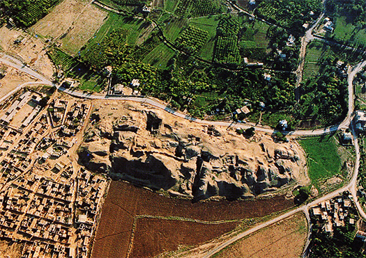
そういう素性の集住・ムラ。古代オリエント世界で約10,000年前には存在が確認されているわけだ。そういうムラのなかでも上の航空写真の「テル・エッ・スルタンの遺丘」というのが初期遺跡。こちらはいまから12,000年前と特定されているとのこと。テルは丘の意味。丘の規模は南北350m・東西150m・高さ2.5m。紀元前9000年頃の痕跡では住居跡はまだ現れないが、石器・骨器や、祭壇と思われる基壇が現れたとのこと。防壁は日本の「環濠集落」と似ているが、目的は洪水から居住域を守るものとされている。この壁の1面には高さ8.5mの石の塔も建てられ「エリコの塔」と呼ばれエジプトにピラミッドが建設されるまで、世界一高い建造物だった。
一方、日本列島でのムラの起源というのを考えるとやはり縄文の「ムラ」といわれる三内丸山遺跡。だいたい今から6000年前〜4000年前ころが最盛期と考古的に裏付けられる。草創は遡って約15,000年前。古代中東では「オアシス」という水に導かれて集落が営まれたけれど、三内ではそういった痕跡はみられない。
日本列島はヒマラヤという高地が偏西風の起点になってそれが日本海を越えて水蒸気を発生させて豊かな雨量を生成して、豊富な森林帯を生み出した。そういう意味で「水」は豊かにあって、実際に三内では建築素材にはクリの木など木材資源が使われる。中東では「石の塔」が建てられるのに対して、巨木による6本柱の建築が集落の象徴、ランドマークのように建てられている。建築の基本が石造に向かっていく世界と、豊かな木造建築文化に向かっていく日本が対比的とも思われる。
三内丸山遺跡の規模は全体で約42ヘクタールとされる。単純比較はできないけれどテル・エッ・スルタンの5ヘクタールを超える広さのムラ空間。さらに言えば、一昨日みた現代のわたしの「ムラ」感覚の及ぶ地域面積は、ほぼ4km四方なので約1,600ヘクタール。人口規模も幾何級数的に拡大した社会であり、また歩きが基本の古代の人びとと、クルマ主体の現代人の違いを考慮すればこの面積相違であっても、人間行動の利用可能行動域として考えれば、そこそこ相似的であるのかもしれない。
象徴的なランドマーク建築などを考えて行くと、人類のムラ集住の基本要素が見えてくるとも思える。現代のわたしの場合、北海道神宮がそういった象徴空間のように思われる。
こういうことがらは、ヒトという存在の地域との関係、帰属認識の基底に近しいのではないだろうか。
English version⬇
The Origin of the Gathering Environment “The World and Japan” Mura and the Comfort of Living – 7
The world’s oldest traces of residential settlement, and the oldest Jomon mura in the Japanese archipelago. And the modern sense of “mura”. There may be a macroscopic “connection” between the two. The world and Japan
The first traces of human settlement “villages” in the world can be found in Jericho, a town in the Middle East region of Judea and Palestine. Here is an excerpt from the Wiki article
〜The town of Jericho was a small settlement in the early Neolithic period, northwest of the Dead Sea, and is one of the oldest towns in the ancient Orient. It is located northwest of the Dead Sea and is one of the oldest towns in the ancient Orient. In the 8th millennium B.C., a settlement surrounded by a wall appeared. It is about 15 km northwest of the mouth of the Jordan River, which flows into the Dead Sea, and is now included in the West Bank of the Jordan River. It is a lowland at -250 m above sea level. There was an oasis called “Sultan’s Fountain” where people settled. It was known as the “City of Palms,” which appears repeatedly in the Old Testament. ~.
A settlement or village of such a nature. The existence of these villages was confirmed about 10,000 years ago in the ancient Orient. Among such mura, the “Remains of Tel Ek Sultan” in the aerial photo above is one of the earliest ruins. It has been identified as being 12,000 years old. Tell means hill. The scale of the hill is 350m north-south, 150m east-west, and 2.5m high. 9,000 B.C. No traces of houses have appeared yet, but stone tools, bone tools, and a base platform, which seems to be an altar, have been found. The wall is similar to the Japanese “moat encircling settlements,” but its purpose is believed to have been to protect the residential area from flooding. On one side of this wall, an 8.5-meter-high stone tower was built, called the “Tower of Jericho,” which was the tallest structure in the world until the construction of the pyramids in Egypt.
On the other hand, when considering the origin of mura in the Japanese archipelago, the Sannai-Maruyama site, which is said to be a Jomon “mura,” is also a Jomon “mura” site. Archaeological evidence supports that the Jomon period was at its peak around 6,000 to 4,000 years ago. The site is said to have been pioneered about 15,000 years ago. In the ancient Middle East, settlements were built by water called “oases,” but there are no traces of such settlements in Sannai.
In the Japanese archipelago, the Himalayan highlands were the starting point for the prevailing westerly winds, which generated water vapor across the Sea of Japan, generating abundant rainfall and creating abundant forested areas. In this sense, “water” is abundant, and in fact, wood resources such as chestnut trees are used as building materials in Sannai. While “stone towers” are built in the Middle East, six-pillar structures made of giant trees are erected as symbols and landmarks of the village. The world, where the basis of architecture is shifting toward stone structures, seems to contrast with Japan, which is moving toward a rich wooden construction culture.
The total area of the Sannai-Maruyama site is estimated to be about 42 hectares. Although a simple comparison cannot be made, the area of the mura space is larger than the 5 hectares of the Tel Ek Sultanate. Furthermore, the area of the modern “mura” as I saw it the day before yesterday is approximately 4 km square, which is about 1,600 hectares. In a society where the population has expanded geometrically, and considering the difference between ancient people who basically walked and modern people who mainly drive cars, even this area comparison may be somewhat similar in terms of the area available for human activities.
When we consider the symbolic landmark architecture, we can see the basic elements of human settlements. In my case today, the Hokkaido Shrine may be such a symbolic space.
These things are probably close to the basis of the human being’s perception of belonging to a region.
共有:

Posted on 2月 20th, 2024 by 三木 奎吾
Filed under: 住宅マーケティング


コメントを投稿
「※誹謗中傷や、悪意のある書き込み、営利目的などのコメントを防ぐために、投稿された全てのコメントは一時的に保留されますのでご了承ください。」
You must be logged in to post a comment.