

日本の街道というのは、経済発展の基盤としての流通の大動脈。律令制国家システムが本格的に導入された奈良の首都建設で大陸国家・唐の都市計画を導入したときに本格的に「官道」が整備されたと伝わる。律令制時代に、中央と地方国府とを結ぶための幹線道路として整備された大型直線道路(五畿七道)などを指す。五畿七道とは、古代日本の律令制における広域地方行政区画。明治になって北海道が加わって五畿八道と呼ばれる。現在の日本各地の地方名の多く(東海、東山、北陸、山陽、山陰、北海道など)は、五畿七道(八道)に由来している。
余談ながらこうした官道整備と並行して輸送手段としての馬が輸入されていった歴史が重なる。列島には馬は自然的には存在せず、こうした官道・街道整備と一体のモノとして馬の輸入・生産も広がっていった。流通を起点とした古代社会での「技術革新」の実態を見る思いがしてくる。
ただ日本は海洋国家であり、物流では伝統的に水運が主力だったことで社会発展に於いて世界の中でも独自の進化をもたらしたように思える。海運・水運が大量輸送の主力であり大都市はそれらの港湾が基盤となり、一方陸路の要衝地というのはより農業を基盤とした流通路として発展したのだろう。この中山道・浦和宿は他の地域とは異なって全部が陸路という独自性がある。浦和宿は戦国時代に発生した「市」が発祥だと考えられている。それが江戸期に整備された中山道の宿場町として発展した。1844年当時で上町96軒、中町47軒、下町69軒の合計212店の商店の記録がある。旅籠・穀屋・水油屋・飲食店・建具屋・道具屋など多様な店舗群。
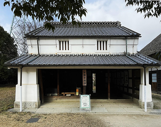
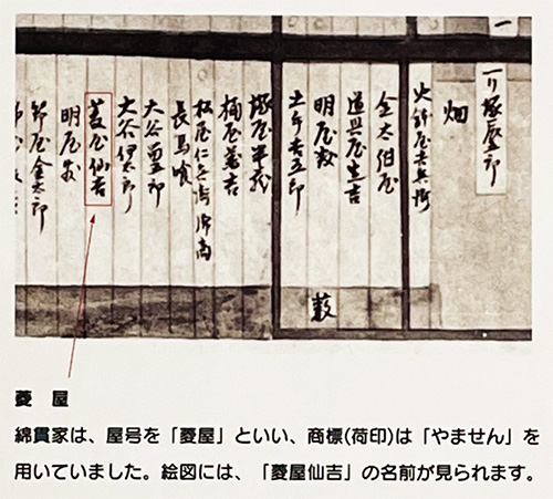
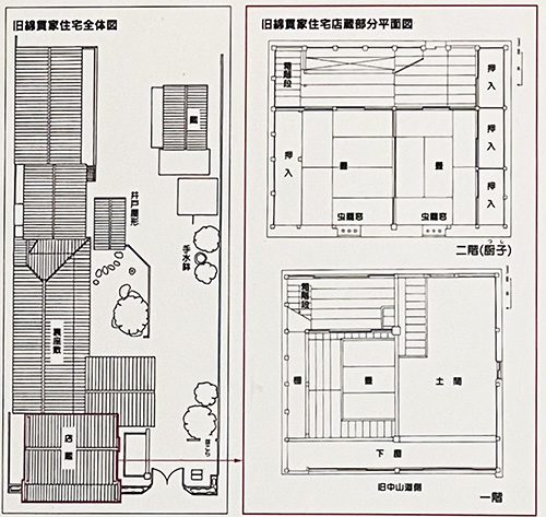
この浦和宿の2軒目の住居一体型の生業町家建築は「荒物・肥料」屋さん綿貫家であります。
中山道の旅客や周辺地域の人びとのさまざまな生活必需品などが商われたことだろう。旅籠・飲食店などを中心にして「歓楽」的要素も大きな吸引力を持って暮らしに彩りをもたらせたに違いない。そしてそうした交流の中から情報も伝達されていった。それもまた地域の人びとにとって生きる支えになったことだろう。周辺の農村的環境とは隔絶した「キラキラ」した地域存在としてあり続けたことだろう。
いわゆる住宅という「住むだけ」機能よりもより人間性の本質を刺激するのがこうした街区環境といえるだろう。どうもこのあたりの人間性の本然の部分が気になってきて仕方ない(笑)。
中山道を中心に裏通りまでの短冊形の地割りであり、建物の間隔1mほどの道があってそれに沿って店舗・蔵・物置・住居棟などが配置されている。綿貫家も間口4間を西に向けた配置図になっている。
前振りが長くなったので、店舗と建築については明日以降に続きます。
English version⬇
A group of stores that fulfill the needs of “Aramono Fertilizer Store” Machiya in Urawa-juku, Nakasendo – 5
The transportation network originating from “government roads” that brought “industry” to the archipelago. The exchange of people, goods, and money stimulates social evolution and the true nature of humanity. The “Nakayamamichi Urawa-juku” townhouses
Kaido in Japan is a major artery of distribution as a foundation for economic development. It is said that “official roads” were developed in earnest when the Ritsuryo system of state system was introduced in earnest when the city planning of the continental state Tang Dynasty was introduced with the construction of the capital city of Nara. The term refers to the large straight roads (Gokyo seven roads) and other roads that were developed during the Ritsuryo period as trunk roads to connect the central government with the local national governments. The Gokyo-Seventh Province was a broad regional administrative division under the Ritsuryo system of ancient Japan. In the Meiji era (1868-1912), Hokkaido was added to the list and the region was called the Ginki Hachimichi (Five Kinai and Eight Provinces). Many of the current names of regions in Japan (Tokai, Higashiyama, Hokuriku, Sanyo, San’in, Hokkaido, etc.) are derived from the Ginki seven provinces (eight provinces).
As an aside, the history of the importation of horses as a means of transportation coincides with the development of these official roads. Horses did not exist naturally in the archipelago, and their importation and production spread as an integral part of the development of these official roads and highways. This is a realistic picture of “technological innovation” in ancient society, with distribution as its starting point.
However, Japan is a maritime nation, and water transportation has traditionally been the main form of distribution, which seems to have brought about a unique evolution in social development. Sea and water transportation were the mainstay of mass transportation, and large cities were based on these ports and harbors, while key locations on land routes developed as distribution routes based more on agriculture. Unlike other areas, Urawa-juku on the Nakasendo Road is unique in that it is entirely an overland route. Urawa-juku is thought to have originated as a “market” that arose during the Warring States Period. In 1844, there were a total of 212 stores (96 in the upper town, 47 in the middle town, and 69 in the lower town). This diverse group of stores included inns, grain stores, water oil stores, restaurants, fixture stores, and tool stores.
The second house in this Urawa-juku, a living machiya building with an integrated dwelling, is the Watanuki house, a “rough goods and fertilizer” shop.
Various daily necessities for passengers on the Nakasendo route and people living in the surrounding areas must have been traded. The “entertainment” element centering on inns, restaurants, and other such establishments must have attracted people to the area and added color to their lives. Information was also transmitted through such interactions. This must have been another source of support for the local people. The area must have continued to exist as a “sparkling” community that was separated from the surrounding rural environment.
It can be said that this kind of town environment stimulates the essence of humanity more than the “living only” function of housing. I can’t help but be curious about the true nature of humanity in this area (laughs).
The land is divided in the shape of a strip of land centering on Nakasendo Road to the back street. There is a road with a distance of about 1 meter between buildings, and stores, warehouses, storehouses, and residential buildings are arranged along it. The Watanuki family also has a layout with a frontage of 4 ken, facing west.
Since the introduction has become lengthy, we will continue with the store and the architecture tomorrow or later.
共有:

Posted on 7月 14th, 2023 by 三木 奎吾
Filed under: 住宅マーケティング, 日本社会・文化研究


コメントを投稿
「※誹謗中傷や、悪意のある書き込み、営利目的などのコメントを防ぐために、投稿された全てのコメントは一時的に保留されますのでご了承ください。」
You must be logged in to post a comment.