
年末年始時期には雪で閉ざされる北海道を離れ、本州以南地域を旅することが習慣化。その旅先も四国などが中心になって最寄りの利便のいい空港は神戸空港。そこから気ままな旅程を組めるレンタカーでの移動が通常ルートになった。そうすると淡路島・瀬戸内海地域行脚が定番化する。
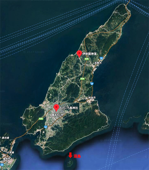
淡路島は環瀬戸内圏の移動交通の要衝。札幌函館間往復600kmが一般的移動範囲である北海道人としては、淡路島というのはそれこそ指呼の距離感覚。旅するうちに、淡路には国生みにまつわる伝承や神社などの存在が多いことに気付かされるようになる。こうした流れで今回は深掘り型におのころ神社参詣。
どうも天沼矛(あめのぬほこ)神話について中央構造線の存在と、鳴門のうずしおのことが強く想像力を刺激される。〜イザナギイザナミの二神は神聖な沼矛(ぬぼこ)で国造り。天の浮橋に立ち授かった矛で混沌とした世界をかき回した。潮をゴロゴロと鳴らし引き上げた矛の先から落ちた雫が固まって島となった。〜
この「かき回し」伝承と鳴門のうずしお、そしておのころ島の擬定地・沼島の上立神岩などの符合に、古代の先人たちの列島自然地形観察の「科学的」解析結果を見るように思える。
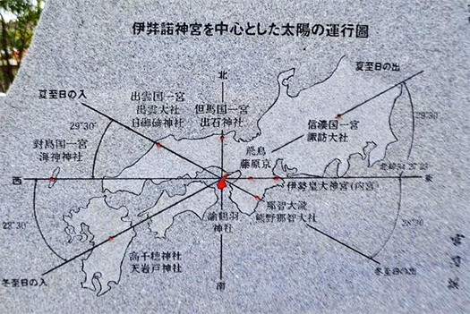
そしてさらに淡路の伊弉諾神宮で見ていた「太陽の運行図」が思い起こされる。この神宮の真東には飛鳥藤原京や伊勢神宮などが位置しているという宮司さん作成になる説明石版図。この図を見ていたときにはこじつけ的な牽強付会説ではないかと疑念を抱いていたのですが、考えて見ると、古代の稲作農業の支配者たる王権にとっては、季節運行の民衆への明晰な説得力のある指示が不可欠だった。いつタネを植え、田にはいつ苗を植えるべきか、それへの合理的判断と指示が決定的に重要だと考えられる。そこには天文観察から自然地形観察、そして太陽の季節運行など多様な解析作業があっただろう。それらは当時の「科学根拠」そのものだっただろう。
国生み神話にあってなぜ淡路が特別な地位を受けていたのか。やはりヤマト王権にとって非常に重要な出自地域だったことを表している可能性が高いと思う。真東に初期王権地の飛鳥・藤原京があり、そこをめざして「東征」した神武の東征行動の方向性が腑に落ちるように思われる。古代には神話であると同時に合理的な根拠行動だったと思われる。神武は橿原に宮を建てたとされるけれど、その子孫・崇神は祭政分離を目指して、伊勢に祭祀中心を移動させ定めていくようになる。
このような王権としての行動意思決定に太陽の道行きが深く考慮されたことは自然だろう。天文観察での北斗星を中心にして方位観測を重ねたに違いない。ただ、たくさんの先人の列島自然観察という経験知はあったにせよ、太陽の道の詳細な特定方法はどうであったのか、現代人としては大きな疑問に突き当たらざるを得ない。
English version⬇
Naruto Uzushio, Izanagi Shrine, and the Path of the Sun: Exploration of Naruto Uzushio and Izanagi Shrine – 3
Asuka, Fujiwara-kyo and Ise Jingu are located directly east of Izanagi Shrine. The Yamato kingdom “conquered” the east to that place. Is there any scientific basis for the ancient principle of action? ……
During the year-end and New Year’s holidays, it has become a habit to leave snowy Hokkaido and travel south of Honshu. The destinations of these trips are now mainly in Shikoku and the nearest convenient airport is Kobe Airport. The nearest convenient airport is Kobe Airport, from which the usual route is to rent a car for a flexible itinerary. In this way, trips to Awaji Island and the Seto Inland Sea region became the standard route.
Awaji Island is a key location for transportation in the Seto Inland Sea area. For Hokkaido residents, who generally travel 600 km round trip between Sapporo and Hakodate, Awaji Island is just a short distance away. As I traveled, I came to realize that Awaji is home to many shrines and folklore related to the birth of the nation. In line with this trend, this time I paid an in-depth visit to Onokoro Shrine.
The existence of the Median Tectonic Line and Naruto’s Uzushio strongly stimulated my imagination about the myth of Amanuma no Mako (Amanuma no Nuhoko). 〜The two gods Izanagi and Izanami created the country with the sacred Nuboko. Standing on the floating bridge of heaven, they stirred up the chaotic world with the sacred spear. The drops that fell from the tip of the spear, which rumbled with the tide, hardened and became an island. 〜The island was an island.
The coincidence of this “stirring” tradition with the Uzushio of Naruto, the pseudo-figure of Onokoro Island, and the Kamitatekami rocks of Numajima, etc., seems to indicate the results of “scientific” analysis of ancient predecessors’ observation of the natural topography of the islands of the archipelago.
This reminds me of the “sun map” I saw at Izanagi Jingu Shrine in Awaji. The map was a lithograph made by a shrine priest explaining that the Asuka Fujiwara-kyo Palace and the Ise Jingu Shrine are located directly east of this shrine. When I was looking at this chart, I had my doubts that it might be a contrived check-and-balance theory, but when I thought about it, it was essential for the royal authority, the ruler of rice farming in ancient times, to give clear and persuasive instructions to the people on the seasonal movements of the seasons. Rational judgment and instructions on when to plant seeds and when to plant seedlings in the rice paddies were considered critically important. This would have involved a variety of analytical work, including astronomical observations, observation of natural terrain, and the seasonal movement of the sun. These would have been the “scientific basis” of the time itself.
Why did Awaji receive a special status in the myth of the birth of the nation? I think it is highly likely that this indicates that Awaji was an extremely important region for the Yamato kingdom. Asuka and Fujiwara-kyo were located directly east of Awaji, the site of the early Yamato kingdom, and it seems to make sense in the direction in which Jinmu’s expedition to the east took place. In ancient times, this was both a myth and a rational basis for action. Although Jinmu is said to have built a palace in Kashihara, his descendant, Choshin, moved the center of rituals to Ise, aiming for a separation of rituals and government.
It is natural that the path of the sun was deeply considered in the decision-making process as a royal authority. They must have made a series of directional observations centering on the North Star in their astronomical observations. However, even though many of our predecessors had the empirical knowledge of observing the nature of the archipelago, we must face a big question as modern people: How did they identify the path of the sun in detail?
共有:

Posted on 5月 1st, 2023 by 三木 奎吾
Filed under: 日本社会・文化研究


コメントを投稿
「※誹謗中傷や、悪意のある書き込み、営利目的などのコメントを防ぐために、投稿された全てのコメントは一時的に保留されますのでご了承ください。」
You must be logged in to post a comment.