
北海道から姫路・播州平野という歴史人跡豊かな地を訪れると、クラクラとさせられる。
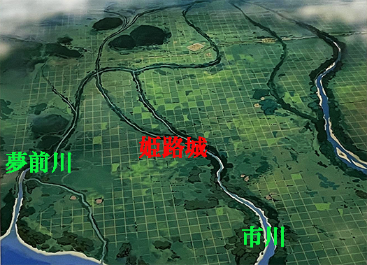
比較対照してみたくなったのは、上のイラスト図が700年代から900年代に掛けての古代の地図を発見してから、どのように「人新世」歴史が積層して、どのように土地空間が変化して行ったのか、アタマのなかが急激に興奮させられたのです。姫路のある平野部、とくにわたしの家系は「夢前川〜ゆめさきがわ」が瀬戸内海に注ぐ土地に蟠踞していたという伝承を持っていることもあって、強いDNA的な探究心が刺激される。あ、ほんとうにDNA的かどうかは、いまのところ「可能性が高い」というものですが。
なんですが、探究していてこの夢前川というネーミングが耳にこびりついてからは、もうメロメロ感が沸き立ってきて仕方がない(笑)。いまわたしはアイヌ語にそのルーツがあるとされる札幌に住んで生きてきたけれど、そしてその地名に深く愛着を感じているけれど、ひょっとして数百年前には夢前川に縁があったかも知れないという浪漫が、カラダの深部に根を張ってしまっているのですね。
現代では明治以降、急発展した神戸が兵庫県の中心になったけれど、それ以前の歴史年代では播州の中心はどちらかと言えば、この姫路が中心だったのだろうと思います。現代の人口規模で53万人は、隣県の岡山の73万人と比較しても、そうひけは取っていない。瀬戸内海の水上交通ではながく大阪への物流の最大拠点だったのではないかと想像できる。飾磨という港湾地域がこの姫路にとってもっとも重要な経済拠点だったのは間違いがないだろうと考えています。
わが家の家系伝承では四国の愛媛地域に拠点を持って、そこから瀬戸内海水運とながく運命共同してきたとされている。
この上の図では、いまの姫路城地域に「播磨国国府」が置かれて、瀬戸内海海運と市川の水運を利用して、古代から繁栄してきたのだという。たぶんその中心地域に対して、夢前川周辺地域はその後の歴史年代では「新開地」という存在だったように想像している。
また、姫路平野には古代からの「条里制」が施設されていたとされて、想像復元の図面ではうっすらと碁盤の目のように規則正しく土地に分割線がみえている。現代のGoogleマップに刻印されている現代の道路区画ともアナロジーさせられる思い。わが家は北海道に移住してきてから約100年前後ということですが、数百年の時間のミッシングリンクが、そこはかとなく遠雷してきます(笑)。たのしい。
English version⬇
Ancient (8th-10th century) and modern Google Maps of the Himeji Castle area
From Himeji to Sapporo. From Yumezaki River to Sapporo Pets. The delusion that we are related by blood rises from every corner of my body. …
A visit from Hokkaido to Himeji and the Banshu Plain, a region rich in historical and human sites, is a craziness.
I wanted to compare and contrast the two, because after discovering the above illustration of an ancient map from the 700s to the 900s, my mind was suddenly excited to see how the “Anthropocene” history was layered and how the land space was changed. My family history in the plains of Himeji, especially in the Yumesaki River area, where the Yumesaki River flows into the Seto Inland Sea, stimulated my DNA-like inquisitiveness. I am not sure if it is really DNA-like or not, but it is “highly likely” at this point.
But after the name “Yumemaegawa” stuck in my ears while I was exploring, I couldn’t help but feel a sense of melancholy (laugh). I have been living in Sapporo, which is said to have its roots in the Ainu language, and I am deeply attached to the name of the place, but I am also deeply rooted in a romantic notion that I may have been related to the Yumezaki River several hundred years ago.
Today, Kobe, which has developed rapidly since the Meiji era, has become the center of Hyogo Prefecture, but in the historical period before that, Himeji was probably the center of Banshu. The modern population size of 530,000 is not so inferior to that of 730,000 in the neighboring prefecture of Okayama. One can imagine that it must have been the largest center of logistics to Osaka for a long time in terms of water transportation on the Seto Inland Sea. I believe that there is no doubt that the port area of Shikama was the most important economic center for Himeji.
According to our family tradition, Himeji had a base in the Ehime region of Shikoku, from where it shared a common destiny with the Seto Inland Sea water transportation system for a long time.
In the above chart, the “Harima Province’s national government” was located in the area of today’s Himeji Castle, and prospered since ancient times by utilizing the Seto Inland Sea shipping and the Ichikawa River. I imagine that the area around the Yumezae River was called “Shinkaicho” in the later historical period.
In addition, the Himeji Plain is said to have had a “jori system” in place since ancient times, and in an imaginary reconstruction drawing, lines of division can be seen in the land as regularly as a goban (a grid pattern). It is analogous to the modern road layouts that are marked on today’s Google Maps. It has been about 100 years since my family moved to Hokkaido, but the missing link of several hundred years of time is still there, thundering in the distance (laughs). It’s fun.
Posted on 12月 24th, 2024 by 三木 奎吾
Filed under: 歴史探訪


コメントを投稿
「※誹謗中傷や、悪意のある書き込み、営利目的などのコメントを防ぐために、投稿された全てのコメントは一時的に保留されますのでご了承ください。」
You must be logged in to post a comment.