
ここ2日ほどはわたしの「新建ハウジングDIGITAL」での新連載記事の紹介というニュースや、すっかり居座った感のある「石狩湾低気圧」による札幌豪雪ぶりで中断させられていましたが、本日からは「ムラと住みごこち」シリーズに復帰いたします。
なんですが、なんと石狩湾低気圧は本日にまで猛威をふるっていまして大豪雪-2であります(泣)。なので、ちょっとまた先に家の周りの除雪をしてきます(笑)。いま、窓の外を確認してふたたび仰天している次第であります。たぶん本日のブログアップは午前7時頃と思われます。
・・・ようやく一段落、終了。たっぷり1時間半かかりました。なかなかことしの冬はしぶとい。きのうの気象台データで、札幌の積雪深(現在時点の積雪の深さを表す)はわたしの住んでいる西区で近い「西野」で2/23−09時現在発表で93cm、平年は83cm。降雪量も416cm、平年414cmといったところ。そこに本日の分が加算されるので、9:00の発表を生暖かく見守ります(泣)。
さて、と、本題に入るところでかなりの時間と体力の消耗感であります。
ムラの住みごこちシリーズ、三内丸山の事例研究に強い執着が出てきております。この遺跡の発見は1992年の調査から本格化したので、つい30年前になります。わたしが生きている間に発見されてその研究が進化してきている。日本列島史のなかでもきわめて記念碑的な発見なのだと思います。
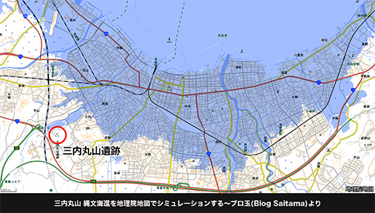
上の地図は三内丸山の縄文海進最盛期(おおむね7000~6000年前)の海岸線を表したもの。この時期の海岸線と三内丸山の距離は約1.3-1.6kmと推定されている。また、その海岸線に向かって流れ込む直近の河川「沖館川」までは350mとごく近接している。
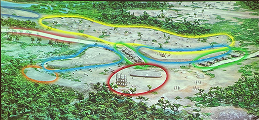
縄文を代表する最大の「ムラ」三内丸山からは容易に河川〜海洋への交通ルートが確保されていたことがわかる。このことは、食糧確保の面でも、またムラ同士の交易関係においてもきわめて重要な要素を物語っていると思う。さらに先日観たように、6本柱建造物は推定高さ14m超というこの時代では世界最高レベルの「高層建築」でもあった可能性がある。青森湾の海上を通行する船からも、はるかに遠望されたに違いない。対岸に位置する北海道島との交流も容易に想像できる。
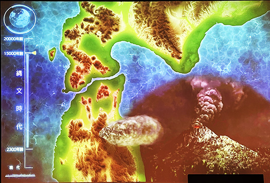
さらにこちらの想像図は、縄文海進が始まる前、三内丸山ムラ痕跡の確認できる最古の15,000年前ころの東北北部−北海道のエリア図。こういう時代には河川の役割がより大きかっただろう。ここまで海岸線が後退していてもなお、いまの三内丸山に人類痕跡があるのは、クリなどの豊富な採集資源があったからではないだろうか。また、いまの青函海峡深部にはこのような時代の痕跡、遺跡が眠っている可能性もあるでしょうね。
ムラを成立させた人類史の奥行きがクラクラさせてくれますね。
English version⬇
Jomon Period, Sannai-Maruyama Coastline Fluctuation Mura and Living Condition-9
The Jomon period (7,000 to 6,000 years ago), the Jomon sea advance peak (15,000 years ago), and the present coastline and environmental reincarnation. …
The last two days have been interrupted by the news of my new series of articles in “Shinken Housing DIGITAL” and the heavy snowfall in Sapporo caused by the Ishikari Bay Low, but I am back to the “Mura to Izakaya” series from today.
However, the Ishikari Bay Low is still raging, and it is snowing heavily again today. So, I’m going to go ahead and plow the snow around my house again (laugh). I’m looking out the window right now and am once again stunned. I will probably post today’s blog around 7:00 a.m.
Finally, I’m done. It took me a full hour and a half. This winter has been a tough one. According to yesterday’s data from the weather bureau, the snow depth in Sapporo (indicating the depth of snow accumulation at the present time) was 93 cm at Nishino, which is close to where I live in Nishi Ward, as of 09:00 on February 23, and 83 cm for a normal year. Today’s amount will be added to that, so we will warmly wait for the 9:00 announcement (tears).
Well, I’m about to get down to business, but it’s been a long time and I’m feeling a bit drained of energy.
I have become strongly obsessed with the Mura’s livability series and the case study of Sannai-Maruyama. The discovery of this site began in earnest with a survey in 1992, so it was only 30 years ago. During my lifetime, its discovery and its study have evolved. I believe that this is an extremely monumental discovery in the history of the Japanese archipelago.
The map above shows the coastline of Sannai-Maruyama at the height of the Jomon sea advance (roughly 7,000 to 6,000 years ago). The distance between the coastline and Sannai-Maruyama during this period is estimated to be about 1.3-1.6 km. The nearest river, the Okidate River, which flows toward the coastline, is only 350 meters away.
It is clear that the largest representative “village” of the Jomon period, Sannai-Maruyama, was easily accessible from the river to the ocean. This is an extremely important factor in securing food supplies and in the trade relations between the villages. Furthermore, as we saw the other day, the six-pillar structure may have been the world’s tallest “skyscraper” of its time, with an estimated height of over 14 meters. It must have been seen from a great distance by ships passing in the distant waters of Aomori Bay. It is easy to imagine the interaction with the island of Hokkaido, which is located on the opposite shore.
Furthermore, this imaginary map shows the northern Tohoku-Hokkaido area around 15,000 years ago, before the Jomon sea advance began and the earliest confirmed traces of the Sannai-Maruyama Mura. In such a period, rivers would have played a more significant role. Even though the coastline has receded to this extent, traces of humans can still be found at Sannai-Maruyama because of the abundant harvesting resources such as chestnuts. It is also possible that traces and remains from this period lie in the depths of the Aohan Strait.
The depth of human history that established the Mura makes me feel dizzy.
共有:

Posted on 2月 24th, 2024 by 三木 奎吾
Filed under: 未分類


コメントを投稿
「※誹謗中傷や、悪意のある書き込み、営利目的などのコメントを防ぐために、投稿された全てのコメントは一時的に保留されますのでご了承ください。」
You must be logged in to post a comment.