
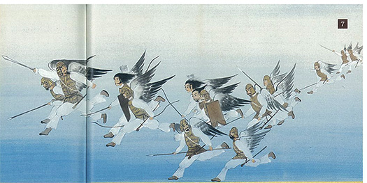
さて神武帝の「大和入り」についての上陸地・熊野からの道探訪篇の最後のルート。神話としては八咫烏に先導させるという神意がもたらされて、三千六百峰といわれる紀伊山地を踏破することになっている。その道筋についてはあまり神話でも触れられていない。以下のような記述が橿原神宮由緒略記にある。
〜磐余彦尊(神武天皇)の兵たちは山をいくつも超えたところで道がわからなくなってしまいました。その時、アマテラス大神が磐余彦の夢にあらわれて申されました。「今、天から八咫烏を道案内として差し向けます。その八咫烏の飛んでいく方向に進みなさい」と教え諭されました。そして八咫烏の力をもって、土着のたくさんの勢力を征し、ようやく吉野川の川上に行き着くことができました。〜
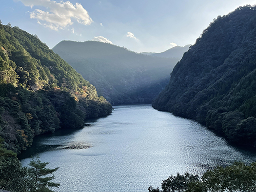
いちばん上の写真は、新宮のガソリンスタンドで「熊野から奈良の方向に行くにはどういうルートなの?」と問うたところ言われたのが「あ、いつも京都にまっすぐ向かう道を地元民は使いますよ(笑)」と教えられて山並みを超えていった頂上付近にあった池原貯水池ダムの水源地地形。
列島地形の中で古来から人間は移動を繰り返していただろうから、八咫烏という道先案内者も、そういった道に沿って導いただろうことがふつうに想像できる。複雑な山岳地形のなかで比較的に安全で合理性の高い「道」が存在し、それが「人が歩けば道になる」道理で、開けていったのだろう。はるかな後世、北海道開拓の150年ほど前には本願寺道路のように人跡未踏の開拓があったけれど、古代から多くの人間が住み,暮らし続けた地域ではそういう「経験知」が伝承されていただろう。
現代にこの国道を走破して、まことに印象的な池原貯水池の様子が視界に飛び込んできたとき、その陶然とした神々しい景観に深く打たれてしまった。内心でこの道に違いないとひそかに確信させられた。橿原神宮由緒略記の地図表記にも、ほぼこの地形位置が表記されている。
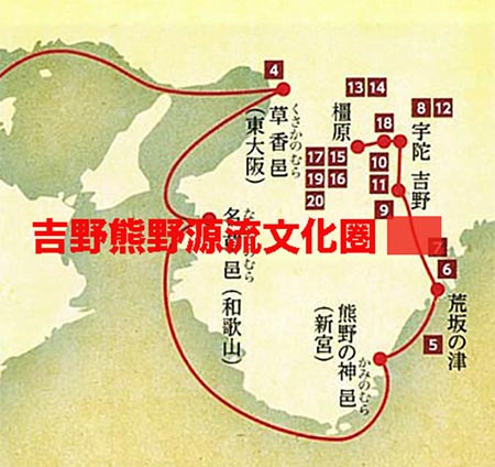
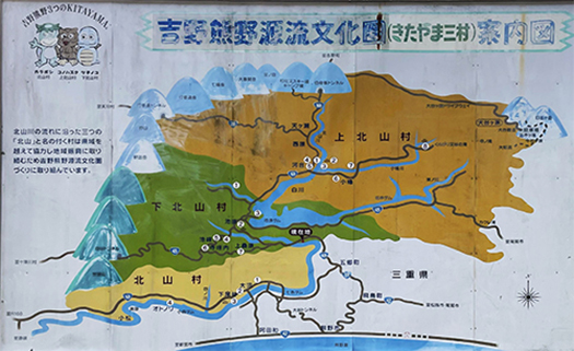
現代では「吉野熊野源流文化圏」という名称で図のような三自治体、三重県と和歌山県にまたがる北山村・上北山村・下北山村が同一文化圏として認識されている。この水源地域から「吉野川」が大和平野に向かって流れていくけれど、皇統神話としての神武帝の一団も、この吉野川に沿って大和地方に下っていったと推定できる。やがて吉野に至り、そしてやや東進して宇陀に入っていくことになる。亡き兄、五瀬命の建てた「日を背にして戦う」という戦略方針に沿って大和平野に向かったのだろう。
そしてやがて大和平野の東端になる三輪山を背にして長髄彦の勢力と死闘を繰り広げて勝利し、そのまま平野をよぎって、宮を造作するための豊かな森林資源、橿が生い茂っていた橿原に宮を造営した。
橿原はわたしの古代史研究のもっともお世話になっている地域。あした、橿原神宮の様子を記述して、このツアー記録の最終章としたい。
English version⬇
From Kumano to Yamato and Yoshino: The Myth of the Imperial Lineage and the Kumano Journey-31
Although Kumano is a myth, it is quite plausible if you follow the path. You can also encounter some very divine landscapes. The Imperial lineage and Kumano are in harmony with each other. The Imperial Lineage and Kumano are inextricably linked.
Now, the last route of the Road Exploration Arc from Kumano, the landing place about Emperor Jinmu’s “entry into Yamato”. According to the myth, the emperor was supposed to have Yatagarasu lead him through the Kii mountain range, which is said to have 3,600 peaks. The route is not mentioned much in the myth. The following description is found in the Kashihara Jingu Shrine Historical Record.
〜The soldiers of the deity Iwayohiko (Emperor Jinmu) lost their way after crossing a number of mountains. At that time, Amaterasu appeared to him in a dream and said, “Now, Yatagataha (three-legged stature) is coming from the heavens. Now, I will send Yatagarasu from the heavens to guide you along the way. Go in the direction in which the yatagarasu flies. With the power of Yatagarasu, he was able to conquer the many native forces and finally reach the top of the Yoshino River. 〜The top photo shows Shingu’s first landing on the Yoshino River.
The top photo was taken at a gas station in Shingu, where I asked the driver, “What is the route to take from Kumano to Nara? The photo above is a natural dam-like water source terrain near the top of the mountain range we crossed.
Since humans have been repeatedly moving in the archipelago’s topography since ancient times, it is common to imagine that Yatagarasu, a guide, would have led people along such a path. In the complex mountainous terrain, there existed “paths” that were relatively safe and rational, and they must have been opened up based on the principle that “if a person walks, it becomes a path. In the far future, about 150 years before the development of Hokkaido, there were pioneer settlements like the Honganji Road that had never been explored by humans, but in areas where many people had lived and continued to live since ancient times, such “empirical knowledge” must have been handed down.
When I traveled this national road in modern times and saw a truly impressive natural dam, I was deeply impressed by the ebullient and divine scenery, and was secretly convinced that this must be the road. The map in the Kashihara Jingu Shuyo Kashihara Shikki also shows this topographical location.
Today, the Yoshino-Kumano Headwaters Cultural Circle is recognized as the same cultural area that includes the three municipalities shown in the figure, Kitayama, Kamikitayama, and Shimokitayama, which straddle Mie and Wakayama Prefectures. From this water source area, the “Yoshino River” flows toward the Yamato Plain, but it can be assumed that the group of the Emperor Jinmu in the imperial mythology also descended along this Yoshino River to the Yamato region. Eventually, they reached Yoshino and then moved slightly eastward into Uda. They probably headed for the Yamato Plain in accordance with the strategic policy of “fighting with the sun on their backs” established by their late elder brother, Gose-no-Mikoto.
He eventually won the battle to the death against the forces of Nagamayuhiko against the eastern edge of the Yamato Plain, Mount Miwa, and built a palace in Kashihara, a place with abundant forest resources for building palaces.
Kashihara is the area that I am most indebted to for my research on ancient history. Tomorrow, I would like to conclude this tour with a description of the Kashihara Shrine.
共有:

Posted on 2月 6th, 2024 by 三木 奎吾
Filed under: 日本社会・文化研究


コメントを投稿
「※誹謗中傷や、悪意のある書き込み、営利目的などのコメントを防ぐために、投稿された全てのコメントは一時的に保留されますのでご了承ください。」
You must be logged in to post a comment.