

きのうから東京に出張。「AIエキスポ」を体感しておりました。が、情報を整理しておく必要性があるので、本日の追加体験も含めて札幌帰還後、まとめたいと思います。
なので本日のブログ記事は最近の流れに即して積丹半島地形篇であります。
ながく北の海の難所として「女人禁制」とまでされていた半島海岸線。わたしは普段は積丹の東側、石狩湾側をよく通行していますが、神威岬を超えた半島東側の地形観察しながら、いまさらながらその怪異ぶりに驚かされておりました。
わたしはテレビ革命世代の人間ですが、少なくともリアルタイム視聴するという習慣はほぼ消滅しています。テレビは「番組編成」ということでそれぞれの放送局が視聴者に予定スケジュールを強制してリアルタイムでの視聴を強いる存在。どうもこういう個人の権利への自己本位の独占的介入はもう時代遅れだと思います。そうではなくこれからの時代は、個人の自由な時間消費、その権利に委ねられるべきだろうと固く信じています。テレビ番組一般に拒否反応を持っているのではなく、やはり好きな情報番組はある。なかでもタモリの地質観察眼部分を最大活用しているブラタモリは録画してみる好きな番組。
話が横道系ですが(笑)、勉強系で歴史に次いで好きだった地学を基礎にしている情報番組って非常に貴重な存在だと思います。
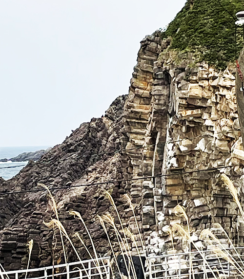
で、この積丹半島の自然地形。1枚目は海岸線に接岸している部位の様子。みごとに異様な岩盤の節理ぶりに驚かされる。2枚目の山頂部の露頭ぶりも、なかなかのリアルな立体感。さらにトンネルの周囲には非常に奇妙な岩盤面が露出している。阿部比羅夫の時代から、海上からこういう光景を見させられてきた本土の人びとが、「蝦夷地・・・」という隔絶観を持ち続けてきた根拠のようにも思われます。
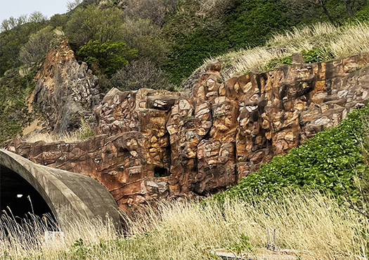
しかし3枚目の写真からはどう見ても自然的な造岩活動だけとは思われない。積丹半島をぐるっと回遊する道路建設は難工事に次ぐ難工事だったとされる。北海道の西側海岸線になかでも最高レベルの岩盤露頭が顕著にみられる。どうもこの写真からはトンネルを掘削したときに、岩盤層がきわめて崩れやすくてそれを安定させるのに、人工的補強材を注入したのではないか。一種の「人新世」痕跡であるのかも知れないと妄想(笑)させられていました。
English version⬇
[Bratamori Hope! Some traces of the Anthropocene? Shakotan Peninsula Topography
Complex traces of stratigraphic and orogenic activities of the earth. Tamori’s keen eye will help you dissect the traces that may have originated in the Anthropocene! Shakotan Peninsula
I started my business trip to Tokyo yesterday. I had a chance to experience the “AI Expo. However, I need to organize the information, so I would like to summarize it after my return to Sapporo, including today’s additional experience.
So, today’s blog post is about the Shakotan Peninsula topography in line with the recent trend.
The Shakotan Peninsula coastline has long been a difficult part of the northern seas, and was even considered a “no women allowed” area. I usually travel along the eastern side of Shakotan, the Ishikari Bay side, but I was surprised to see the bizarre topography of the eastern side of the peninsula beyond Cape Kamui.
I am a member of the TV revolution generation, but at least the habit of watching TV in real time has almost disappeared. Television is a form of “programming” in which each broadcaster forces its viewers to watch in real time by forcing them to follow a schedule. Apparently, this kind of self-centered, monopolistic intervention in individual rights is already outdated. Instead, I firmly believe that the future should be left to the free consumption of time and the rights of the individual. It is not that I have a rejection of TV programs in general, but I still like some information programs. Among them, Bratamori, which makes maximum use of the geological observation eye part of Tamori, is my favorite program to record.
I know this is a bit of a side-track (laughs), but I think it is very valuable to have an information program based on geology, which is second only to history in my favorite field of study.
The first picture shows the natural topography of the Shakotan Peninsula. The outcrops at the top of the mountain in the second picture are also quite realistic and three-dimensional. The outcropping at the top of the mountain in the second photo also has a very realistic three-dimensional appearance. This seems to be the basis for the segregated view of “Ezo…” held by people on the mainland who have been forced to see this kind of scene from the sea since Abe Hirao’s time.
However, from the third photo, it does not appear to be only natural rock-forming activity. It is said that the construction of the road that circles the Shakotan Peninsula was one difficult task after another. The highest level of rock outcrops can be seen on the western coastline of Hokkaido. The photographs suggest that when the tunnel was excavated, the bedrock layer was extremely fragile and artificial reinforcement was injected to stabilize it. I was made to fantasize (laugh) that it might be a kind of “Anthropocene” trace.
共有:

Posted on 5月 12th, 2023 by 三木 奎吾
Filed under: こちら発行人です


コメントを投稿
「※誹謗中傷や、悪意のある書き込み、営利目的などのコメントを防ぐために、投稿された全てのコメントは一時的に保留されますのでご了承ください。」
You must be logged in to post a comment.