

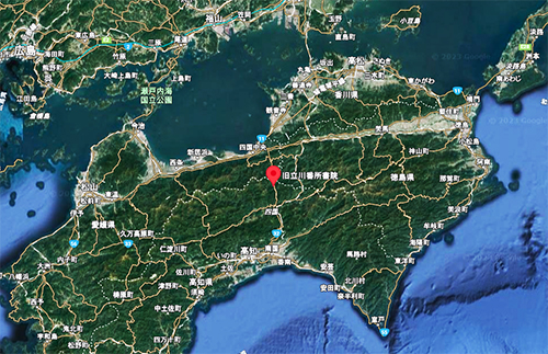
四国行脚篇シリーズ、今回からは高知県と香川・愛媛の県境地域、立川にある旧藩時代の「番所」。重要文化財指定を受けている古建築で、江戸期寛政年間の創建。いまから約210年前のもの。1974年に国の重要文化財指定を受け、1980年に総工事費約1億円を掛けて解体復元工事がなされた。
高知県地域は四国を東西に走る山岳地帯・四国山地によって瀬戸内海側地域とは隔絶している。このことは古代から近世まで地域の特徴としてながく語られてきた。古代の「南海道」について、和銅2年(711年)の制で定められたものでは、平城京から紀伊〜淡路〜阿波〜讃岐〜伊予宇和郡を経由して土佐に至るとされている。南海道の最果て。
これではあまりに遠国扱いになることから、養老2(718)年の続日本紀には「その道は伊予国を経る。行程迂遠。」との記載。ということで土佐国国府からの奏請を受けて、阿波国から土佐に通じる道を選び路程を短縮した、とあるけれどその行程ルートは明らかではない。
その後、延暦16(797)年にはこの立川を通る山道が開削されて、土佐と他地域の交流経路になったとされている。この間80年以上にわたって交通路探索が行われてきた実相が伝わってきて興味深い。古代に於いても地域開発の不断な努力が試みられてきた様子がわかる。日本史でもっとも最近地域開発された北海道人としては、格別にシンパシーを感じる部分がある。「土佐国も古代にはそんなに苦労していたんだね」という親近感を覚えさせられる次第(笑)。四国行脚でもこの高知・土佐の旅に格別の思いを抱いているのにはこういう心情も大きな部分だろうか。
江戸期に至っても、国主の「参勤交代」ルートは当初は海路を使っていたようだけれど、それでは安定した日程立案できないことから、やがてこの立川ルートを使うようになったという。そこで藩主が休息する「番所」が置かれることになったことが、この建物の建築動機。
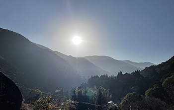
現代では高速道路がこの山岳道路に並行して走っている。最寄りターミナルは立川より南の大豊になる。そこで高速を下りて山道を走るのだけれど、これが曲がりくねった山道で、古代からの昔人のみなさんの労苦が伝わってくる思いがします。
立川から四国山地を見回せば、いかにこの地が高地であるかもわかる。建物探訪ですが、周辺環境・立地条件を考えて見ただけで紙数が尽きた(笑)。続篇はあした以降に。
English version⬇
Former Tachikawa Bansho Shoin / A key point on the mountain road north of Kochi
Since the Nankaido (Southern Sea Route) was established in the Nara Period (710-794), Tosa Province has suffered as a region with difficult transportation routes due to the Shikoku Mountains. This is a strategic point for a mountain land route to break through the mountainous region. The area is also known as the “Keystone of the Mountain Road” in Japan.
The Shikoku Travels series begins this time with a “guard house” from the old domain era located in Tachikawa, on the border between Kochi Prefecture and the prefectures of Kagawa and Ehime. This old building, designated as an important cultural property, was built in the Kansei era of the Edo period (1603-1868), about 210 years ago. It was designated a National Important Cultural Property in 1974, and was dismantled and restored in 1980 at a total cost of approximately 100 million yen.
The Kochi Prefecture area is separated from the Seto Inland Sea area by the Shikoku Mountains, a mountainous region running east to west across Shikoku. This has been a characteristic of the region from ancient times to modern times. According to the ancient “Nankaido” (Nankaido means “Southern Sea Route”), which was established in 711, it runs from Heijo-kyo to Tosa via Kii, Awaji, Awa, Sanuki, and Iyo-Uwa counties. The farthest end of the Nankaido.
The Shoku Nihongi of 718 states, “The road goes through Iyo Province. The route is long. The road goes through Iyo Province. Therefore, it is said that the road leading to Tosa from Awa Province was shortened in response to a request from the Tosa Provincial Government, but the route is not clear.
Later, in 797, a mountain road was opened through Tachikawa, which is said to have served as an exchange route between Tosa and other regions. It is interesting to learn that the search for transportation routes has been conducted for more than 80 years during this period. It shows that even in ancient times, constant efforts were made to develop the region. As a native of Hokkaido, the most recently developed region in Japanese history, I feel a special sympathy for this region. I can feel a sense of affinity with the people of Tosa Province, who must have had a hard time in ancient times. (Laughs). This sentiment may be a major part of the reason why I feel a special affinity for this trip to Kochi and Tosa in my Shikoku itinerary.
In the Edo period (1603-1867), the feudal lords used to travel by sea, but this route was not stable enough for them to make a schedule, so they eventually began to use the Tachikawa route. The construction of this building was motivated by the fact that a “guard house” was built here for the feudal lord to rest.
Today, an expressway runs parallel to this mountain road. The nearest terminal is Otoyo, south of Tachikawa. There, we get off the highway and drive along the mountain road, which is a winding mountain road that reminds us of the laborious efforts of people in ancient times.
If you look around the Shikoku Mountains from Tachikawa, you can also see how high the land is. This is an exploration of buildings, but I ran out of paper just looking at the surrounding environment and location (laugh). I will continue the story in the next day or so.
共有:

Posted on 4月 20th, 2023 by 三木 奎吾
Filed under: 住宅マーケティング, 歴史探訪


コメントを投稿
「※誹謗中傷や、悪意のある書き込み、営利目的などのコメントを防ぐために、投稿された全てのコメントは一時的に保留されますのでご了承ください。」
You must be logged in to post a comment.