
渋谷川を望む東渋谷台地には縄文時代から古墳時代の遺跡が確認されている。
台地の縁辺には古墳時代の集合墓・横穴墓群も営まれていた。
近世・近代の氷川裏(氷川神社の裏手?)には薩摩藩下屋敷や皇室御用地、
東伏見宮邸、李氏朝鮮ゆかりの邸宅群、朝鮮人女学生寮なども置かれていた。
〜國學院大學博物館資料より。
在学時にはあんまり熱心な学生ではなかったのにはるかに時間を経て
ときどき、東京出張時には散策するようになった時空超越学徒(笑)。
今回、タイムトラベルの寸暇を得てはじめて見た碑文。
ほえ〜であります。
ちょっと前までブログでは旧石器時代の列島人について探究していた。
なので、こういう記述に出会うとその奇遇に驚かされる。
大学時代にはいろいろな大学の演劇研と交流してあちこち放浪していたので
こういう邂逅はまことに驚かされます。
國學院大學メディアというWEBサイトで面白い記事を発見した。
「渋谷にも古代人がいた!スクランブル交差点に人が集まるのは必然だった!?
渋谷を発展させた“地形からのメッセージ” 」
〜シブヤの古代人が暮らしていた場所は今の一等地
河川の下刻作用がもたらした文化や暮らしが、現代の礎に〜。
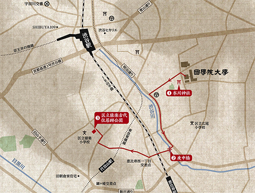
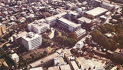
國學院大學が位置する渋谷区東は“東渋谷台地”と呼ばれる高台。大学の隣の
氷川神社に行くとよく分かるが、相当な高低差を体感することができる。
坂を下ると明治通りに沿うかたちで渋谷川が流れている。縄文時代は
狩猟、漁撈、採集など川沿いの高台は食料獲得場所として好立地だった。
武蔵野と聞くと国分寺の方をイメージする方も多いが、実はこの場所は
“武蔵野台地”の東の端で“山の手”と呼ばれる中心地。スクランブル交差点付近は
かつては川が流れるだけの低湿地帯なので食料確保か水上を移動する以外には
行く目的がない。近代以前は氷川神社境内のような風景がこの辺一帯に広がって、
温暖で海面が高かった縄文時代前期は、海も近く利便性に長けた地域だった。
縄文人は一等地としてここを選択した。・・・
現代の我々は首都としてこの土地を訪れるのだけれど、
はるかな時間の中ではこのような土地認識が優越すべきなのでしょうね。
東京が江戸として都市開発されてから約450年ほど。
家康は関東に入部するとき根拠地として秀吉から強く江戸を勧められたとされる。
はからずも縄文人たちの土地選択と通底するような選択眼が
秀吉にはあったのかと思えるけれど、そうではなく
かれは大阪と同様の海運利便性として江戸湾を見出して
「ま、大阪よりは発展可能性は小さいだろう・・・」という安心感で
この程度の親切心はと思って勧めたのだろうと思う。
はるかな時間を経て、北海道人としてもこういう視点は
まことに興味を深くさせられるものです。
English version⬇
Tokyo “Shibuya Plateau” History since Jomon Period
The East Shibuya Plateau overlooks the Shibuya River along Meiji-dori. A group of ruins from the Jomon period has been confirmed. The high plateau along the river was a prime Jomon site for hunting, fishing, gathering, and other activities. Jomon Period
On the Higashi-Shibuya Plateau overlooking the Shibuya River, remains from the Jomon and Kofun periods have been found.
On the edge of the plateau, a group of burial mounds and side tombs of the Kofun period were also constructed.
The area behind Hikawa (behind Hikawa Shrine?) in the modern and early-modern periods was a site of the Satsuma Domain’s subordinate clans. In the modern and early modern period, the area behind Hikawa Shrine (behind Hikawa Shrine?) was the residence of the Satsuma clan, the imperial household, the Higashifushimi Palace, and the Lee family.
The Hikawa-ura (behind the Hikawa Shrine?) in the early modern period was also the residence of the Satsuma clan, the imperial household, the residence of the Higashifushimi Palace, a group of residences associated with the Yi clan, and a dormitory for Korean female students. The Satsuma Clan’s residence
〜From the Kokugakuin University Museum.
I was not a very enthusiastic student when I was a student at Kokugakuin University, but much time has passed since then.
Sometimes, when I go on business trips to Tokyo, I have become a student of time and space transcendence (laugh).
This time, I had a chance to travel back in time and saw the inscription for the first time.
I was surprised to see it.
Until a little while ago, I had been exploring Paleolithic archipelago people on my blog.
So I was surprised at the oddity when I came across this kind of description.
When I was a university student, I was wandering around and interacting with theater groups at various universities, so this kind of encounter is truly amazing.
I was really surprised at such a chance encounter.
I found an interesting article on the Kokugakuin University Media website.
There were ancient people in Shibuya! It was inevitable that people would gather at the scramble crossing!
Message from the topography” that developed Shibuya.
〜The place where the ancient people of Shibuya lived is now a prime location.
The culture and lifestyle brought about by the downstream action of the river has become the foundation of the present day.
Kokugakuin University is located in the eastern part of Shibuya Ward, on a plateau called the “Higashi-Shibuya Plateau. The university is located next to Hikawa Shrine.
Hikawa Shrine, which is located next to the university, you can feel the considerable difference in elevation.
Down the hill, the Shibuya River flows along Meiji-dori Avenue. In the Jomon period
In the Jomon period, high ground along the river was a good location for hunting, fishing, and gathering food.
Many people think of Musashino when they hear the word “Musashino”, but in fact, this place is called “Musashino Plateau”.
Musashino is actually the eastern edge of the “Musashino Plateau” and the center of the “Yamanote” or “Yamanote” area. Incidentally, the area around the scramble intersection is
The area around the Scramble Crossing used to be a low marshy area with only a river flowing through it.
There is no purpose to go there except to get food or to travel on the water. In the pre-modern era, the scenery around this area was like the precincts of Hikawa Shrine, and the warm temperatures and high sea level made it a perfect place for rope writing.
Before and after the Jomon period, when the area was warm and sea level was high, it was a very convenient area near the sea.
The Jomon people chose this area as a prime location. The Jomon people chose this area as a prime location.
We visit this place today as a capital city.
In a far distant time, this kind of perception of the land should prevail.
It has been about 450 years since Tokyo was first developed as Edo.
It is said that Ieyasu was strongly recommended Edo by Hideyoshi as a base for his entry into the Kanto region.
I wonder if Hideyoshi had an eye for land selection that was similar to that of the Jomon people.
However, this is not the case.
He found Edo Bay to be as convenient for shipping as Osaka, and said, “Well, it is more developable than Osaka.
He was relieved that the possibility of development would be smaller than that of Osaka, and
I think that he recommended Shukichi with this level of kindness.
After a long time, this kind of viewpoint is very interesting to us Hokkaido people.
I am very interested in this kind of viewpoint as a person from Hokkaido.
共有:

Posted on 11月 1st, 2022 by 三木 奎吾
Filed under: こちら発行人です, 住宅マーケティング


コメントを投稿
「※誹謗中傷や、悪意のある書き込み、営利目的などのコメントを防ぐために、投稿された全てのコメントは一時的に保留されますのでご了承ください。」
You must be logged in to post a comment.