本文へジャンプ

【3連休初日 札幌はかなりの豪雪かなぁ・・・】


さていろいろ住宅業界関係の情報交流が盛り上がっていた週も終わって、本日から3連休ということですが、札幌は昨日終日の雪景色で、市内でも見通しが50mもないような降雪状況。体力的に疲れもたまっていたこともあって、夕方6時過ぎには、すぐに爆睡モード。年寄りはこういうのだけは「すばやい」(笑)。
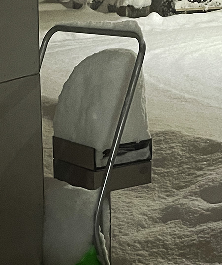
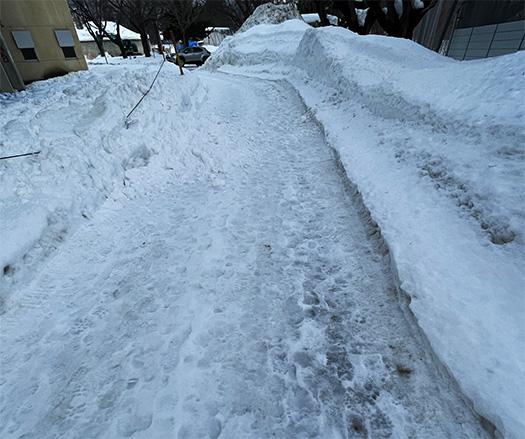
ということで本日午前2時過ぎに目覚めたら、ごらんのようなわが家周辺状況。昨日22日に多少はあらあらの除雪をしておいたのですが、その除雪痕跡はきれいになくなっております。すごい・・・。
目視的には50-60cmクラスの積雪のようです。
気象台の警報発令は昨晩で「札幌・江別に大雪警報」ということでしたが、どうも警報発令は後手を踏んでいるように思われ、今回は札幌集中的な降雪に不意を突かれた感じ。
大豪雪のように思うのですがまだ降雪は続いていますので、先行きも見通しにくい。本日東京に移動して住宅撮影のスタッフもいるのですが、さて動けるのかどうか、不安。
いま午前3時過ぎに再度周辺を確認したところ、公共の除雪車は一回除雪に入ったようで、道路側からわが家建物側に向かって除排雪を試みていくことがベストのような様子。また、降雪もやや小降りから止みつつある。
ということですので、ブログ執筆中ですが早々に除雪を開始しようかと考えております。
気温がマイナス7度という発表なので、雪質はたぶん湿度の低いカラッとした粉雪だろうと想像される。豪雪だけれど、除雪作業自体はたぶんややラクかも知れません。いったんブログ執筆を中断して、除雪をしてきたいと思います。その上で、再度記録文として加筆します。

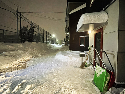
・・・約1時間ほど、除雪してきました。公共の除雪以降も10cm以上は積雪していました。途中雪が収まったかと思ったのですが、依然として小降りが継続。とりあえず応急的にライフライン要素、駐車場に置いているクルマをいったん救出して雪山堆雪箇所に雪を盛り上げて、駐車場の必要面積分プラスアルファ程度の除排雪を行った。その他、最低限のライフライン箇所を除排雪し、敷地の1/2程度の除排雪を行ったところで、いったん休止であります。どうせまだ降雪は続いているので、息長く、お天気具合と対話しながらあくせくせずに当たっていきたい。
このあと、このブログを書き終わってカミさんが起き上がってきたら、いっしょに残務除排雪を行っていきたいと思います。周辺には借りている駐車場スペースが6台分あるので、そちらの用途確保のためにも除排雪を。これが面積的にはたぶん3倍程度にはなるのですね。
ということで雪国の大雪と夜間の除雪の実況中継入り、特別ブログでした。もうこういうのは今年最後にしたいと切に思う次第。・・・

English version⬇

First day of a three-day weekend… Sapporo is getting heavy snowfall.
Sapporo’s snowfall is so concentrated that even the weather station’s forecast couldn’t keep up with it. Or the local “demon” called Ishikari Bay low pressure system is on a rampage. It can’t be helped, can it? …….

The week of various information exchanges in the housing industry has come to an end, and today is the third consecutive holiday, but it snowed all day yesterday in Sapporo, and even in the city, the visibility was as low as 50 meters. I was physically exhausted and fell asleep right after 6 pm. Old people are quick in this kind of thing (laugh).
So when I woke up a little after 2:00 a.m. today, the situation around my house was as you can see. I had removed some of the rough snow yesterday, but all traces of it are gone. Amazing….
Visually, it looks like 50-60 cm of snow has accumulated.
The weather bureau issued a “heavy snow warning for Sapporo and Ebetsu” last night, but the warning seems to have been issued late, and this time we were caught off guard by the concentrated snowfall in Sapporo.
It seems like a heavy snowfall, but the snowfall is still continuing, so it is difficult to predict the future. Some of our staff members are moving to Tokyo today to take pictures of houses, but I am not sure if they will be able to move.
I checked the area again after 3:00 a.m., and it seems that the public snowplows have started clearing the snow once, and it seems that it is best to try to remove the snow from the road side toward our building. Also, the snowfall has stopped after a slight drizzle.
So I am thinking of starting snow removal as soon as possible, even as I write this blog.
Since the temperature is -7 degrees Celsius, I imagine that the snow will probably be dry and powdery with low humidity. Although it is a heavy snowfall, the snow removal work itself may be a little easier. I would like to stop writing this blog for a while and go to the snow removal site. Then I will add the record again.

…I have been plowing snow for about an hour. There was still more than 10 cm of snow on the ground since the public snow removal. We thought the snow had stopped on the way, but it still continued to fall lightly. For now, we temporarily rescued the lifeline elements, the cars in the parking lot once and heaped up snow at the snow pile composting points, and removed snow from the necessary surface area of the parking lot plus about an additional amount. We also removed snow from the minimum lifeline points, and once about 1/2 of the site was cleared of snow, we paused. The snowfall is still continuing anyway, so we will continue to work without rushing, while interacting with the weather conditions.
After I finish writing this blog and my wife wakes up, we will go to the snow removal site together. There are six rented parking spaces in the vicinity, so we will also remove snow to secure their use. So this will probably be about three times the area.
So this was a special blog with a live report of heavy snowfall and nighttime snow removal in snow country. I am really hoping that this will be the last time this year. I hope this will be the last time this kind of thing will happen this year.

【住宅業界誌「新建ハウジングDIGITAL」に連載記事】


かねてから準備していた表題の連載執筆、きのう2/21に掲載開始されました。
https://www.s-housing.jp/archives/339365
わたしの基本的な立場としては北海道東北での地域を挙げた「高断熱高気密」住宅革新運動のさまざまな領域に寄り添って「協働」してきたのではと思っています。積雪寒冷という自然環境の中で、日本人の「暮らし方フロンティア」であったのが北海道の立ち位置。そこで地域自治体は明治初年から連綿と住宅環境向上について積極的に施策を推進してきたし、そのための専門研究機関まで創設してきた。
この地で暮らす生活者の切実な願いを受け止めて地域に密着した工務店・ビルダーや建築家のみなさんたちは創意工夫を重ねてきた。北海道大学をはじめとする研究者としての建築関連の学究のみなさんも大いに「協働」しながら地域は住宅革新を遂げてきた。
もちろんこれまでもこれからもスタッフと作り上げてきた地域住宅雑誌・Replan誌との強い協働性は不変。Replan誌では生活者の視線に立って、進化してきた住環境をわかりやすくルポルタージュしてきました。今後ともその立場に立って、この新建ハウジングDIGITAL連載記事では全国のみなさんに情報発信していきたいです。その上でマーケティング面など専門情報的な部分を掘り下げたいと思います。
こうした新たな情報発信を通じて、すこし距離感のある北海道東北と以南地域の作り手のみなさんとも交流が実現できたらと念願しています。ちょうどいま時期は本州地域の作り手のみなさんがさかんに北海道住宅の研究ツアーに来られています。きのうは青森から来られたビルダーの方がある会合で発表されていました。地域の住まい手のみなさんの生々しい暮らし方情報まで含めて感受できた。最初期から見続けてきて、そういった業界全体の発展状況、躍動ぶりもまことに隔世の思いをしております。
しかし時代はいま人口減少という未曾有の局面を迎えてきている。ながく新築住宅の需要が旺盛だった時代から市場は大きく変化してきている。
連載記事でもそういった側面について考えを進めていければと思っています。
しかし、この「毎日更新」のブログ連載はライフワークとしていきたいのでこういう連載記事の仕事など「書く」仕事がメインになってきつつあります。使い続けていれば体力の減退は防止できるというような説がありますが、さて脳内について可能かどうか、不安との戦い(笑)でもあります。

English version⬇

[Serialized article in the housing industry magazine “Shinken Housing DIGITAL
Changes in the work environment have forced me to deal with yet another new area. I would like to work with a firm sense of urgency. …

The series of articles I have been preparing for some time was published yesterday, February 21.
My basic position is that I have been “collaborating” in various areas of the regional “highly insulated and airtight” housing innovation movement in the Tohoku region of Hokkaido. Hokkaido’s position is that it has been the frontier of Japanese people’s “way of life” in the natural environment of snowy and cold climate. Local governments have been actively promoting measures to improve the housing environment since the early Meiji era, and have even established specialized research institutes for this purpose.
In response to the earnest wishes of the people living in this area, local construction companies, builders, and architects have been working on the project with great creativity and ingenuity. Hokkaido University and other architectural academics have also worked together to bring about housing innovation in the region.
Of course, there has been and will continue to be strong collaboration with Replan magazine, a regional housing magazine that has been created by our staff, and which has provided easy-to-understand reportage of the evolving living environment from the viewpoint of consumers. I would like to continue to take that standpoint and provide information to everyone in Japan in this Shinken Housing DIGITAL series of articles. In addition, I would like to delve deeper into marketing and other specialized information.
Through this new information dissemination, we hope to establish communication with makers in the Tohoku and southern regions of Hokkaido and beyond, where there is a slight sense of distance between them. At this time of year, many builders from the Honshu region are visiting Hokkaido on research tours. Yesterday, a builder from Aomori gave a presentation at a meeting. I was very impressed with the information including the vivid living style of the local residents. Having followed the industry since its early days, I feel as if I am a generation removed from the development and dynamism of the industry as a whole.
However, we are now entering an unprecedented phase of declining population. The market has changed dramatically since the days when demand for new housing was strong.
I hope to continue thinking about this aspect of the market in my series of articles.
However, I want to make this “daily updated” blog series my lifework, so “writing” work such as this kind of serial article work is becoming my main focus. There is a theory that if you keep using it, you can prevent the decline of your physical strength, but I am also fighting a battle with anxiety (laugh) to see if it is possible to keep it in my brain.

【5-6千年前「縄文のランドマーク」 ムラと住みごこち-8】


人類と集住的共同体「ムラ」的生き方について考えて見ています。人口減少局面でこれまでのような新築住宅建設にどっぷり依存した住宅産業構造から、どうすれば既存建築の高度化需要を考えていけるのかと問題を立てれば、人間のシアワセの根源要素を見返す必要がある。
簡単に言って住宅リフォームの需要促進にはなにが必要かと考えれば、人間は「限界集落化」していくような街区に対してよりも「よき住宅地」に対して投資的になれるだろうという判断。
たとえば現状のなかで性能向上型リフォームに対して60代前後の世代は、いったいどうすれば動機を持てるのかというテーマ。ひとつ考えられるとすれば「よき住宅地」にある資産としての住宅を、子や孫世代のためにと考えさらに価値向上させたいという資産継承的需要。
もしくは30-40代の若年層が、既存の「よき住宅地」にある比較的安価な中古住宅を購入してその住宅を性能向上させてよき人生を獲得したいと考える需要。
このふたつの需要動機が考えられるけれど、どちらにしても人口減少局面ではより大きく「住宅地」の価値感に注目が集まるのではないかという直感であります。その「良き住宅地」判断の目安にはいったいどういう基準があるか。人間居住環境としての「ムラ」的魅力を探究したいのです。
そういったテーマ意識から昨日は世界最古の集住「ムラ」環境について調べてみた次第。そこで石造の「塔」建築が地域の「ランドマーク」であった事実を知った。しかもエジプトにピラミッドが建設されるまで世界最高の高さの建築だったという。人間意識にとってこういう象徴的建築には、ムラ的愛着を刺激するなにか根源的要素があるのかもしれないと。
そうした流れから、三内丸山の列島最古の「大型掘立柱建物」が強く脳裏に再生されてきた。
これは大型掘立柱建物跡をもとに高さ14.7mの建物として復元されたもの。建築用途としては神殿、物見やぐら、モニュメントなどの説が唱えられている。復元図を参照すれば遺っていた基底部の木片の大きさ・掛かっていた土圧の分析結果などから推定された。しかもこれら柱穴は4.2m間隔で規則的に配置されている。
やはり目的的建築、ムラの統合性を表現したランドマークだったことが想像できる。単純に高層建築として、その建物が「見える空間範囲」というテリトリー意識にはわかりやすい普遍性を感じる。
縄文というのは基本は採集と狩猟が生業だけれど、日本列島では海浜での漁労という非常に「豊かな」食糧確保手段が確立されていた社会。狩猟が獲物としての陸上動物の季節移動に随伴して移動する暮らしようだったのに対して、定住性がきわめて高かった。
どうもわたしには、この三内丸山が列島社会の「八百万」のムラ社会、自然な地域共同体の始原的姿なのではないかと思えてならないのです。

English version⬇

5-6,000 years ago “Jomon landmarks” Mura and livability-8
Survival as a group has been a natural state of human beings since the beginning. Ease of living and livability are probably the greatest factors that attract humans. …

We have been thinking and looking at the human race and the “mura” way of living, a community of people living together. If we ask ourselves how we can shift from a housing industry structure that relies heavily on new housing construction to one that considers the demand for upgrading existing buildings, we need to look back at the root elements of human sheer willpower.
Simply put, what is needed to promote demand for home renovation?
For example, how can we motivate people in their 60s to renovate their homes to improve performance? One possibility is that they would like to improve the value of their homes as assets in “good residential areas” for their children and grandchildren, as if they were inheriting the assets.
Or, young people in their 30s and 40s who purchase relatively inexpensive existing houses in “good residential areas” and wish to improve the performance of their houses to lead a better life.
In either case, my intuition is that the declining population will focus more attention on the value of “residential areas. What criteria should be used to determine what constitutes a “good residential area”? I would like to explore the attractiveness of “mura” as an environment for human habitation.
With this in mind, I spent yesterday researching the world’s oldest residential “mura” environment. There, I learned that stone “towers” were local “landmarks. Moreover, they were the tallest structures in the world until the construction of the pyramids in Egypt. I thought that such symbolic architecture might have some fundamental element in human consciousness that stimulates mura-like attachment.
This process brought to mind the oldest “large hottate-bashira” building in the archipelago at Sannai-Maruyama, which is the site of a large hottate-bashira building.
This is a 14.7-meter-high building reconstructed from the ruins of a large hottate-bashira building. Some people have suggested that it was used as a temple, a watchtower, or a monument. The size of the wood chips at the base and the results of the analysis of the soil pressure on the building were estimated by referring to the restored drawings. Moreover, these post holes are regularly spaced at 4.2m intervals.
It can be imagined that this was a landmark expressing the purpose of architecture and the integrity of the mura (village). As a simple high-rise structure, the building’s territorial awareness of the “visible range of space” has a sense of universality that is easy to understand.
The Jomon were a society whose basic livelihood consisted of gathering and hunting, but in the Japanese archipelago they had established a very “rich” means of securing food by fishing on the seashore. While hunting was a way of life that moved along with the seasonal migration of land animals as prey, the society was highly sedentary.
I can’t help but think that Sannai-Maruyama is the primitive form of the “eight million” village society of archipelagic society, a natural regional community.

【集住環境の始原「世界と日本」 ムラと住みごこち-7】


世界での人間の集住「ムラ」初源期の痕跡はユダヤ、パレスチナといった中東地域の町・エリコの名が挙げられる。以下Wiki記述要旨抜粋。
〜初期は小規模な定住集落で時代区分上は新石器時代にあたる。死海の北西部にあり古代オリエントの中でも古い町。紀元前8000年紀には周囲を壁で囲った集落が出現。死海に注ぐヨルダン川河口から北西約15kmで現在はヨルダン川西岸地区に含まれる。海抜マイナス250mの低地。「スルタンの泉」と呼ばれるオアシスがあり、人々が住み着いた。『旧約聖書』にも繰り返し現れ「棕櫚(しゅろ)の町」として知られていた。〜
そういう素性の集住・ムラ。古代オリエント世界で約10,000年前には存在が確認されているわけだ。そういうムラのなかでも上の航空写真の「テル・エッ・スルタンの遺丘」というのが初期遺跡。こちらはいまから12,000年前と特定されているとのこと。テルは丘の意味。丘の規模は南北350m・東西150m・高さ2.5m。紀元前9000年頃の痕跡では住居跡はまだ現れないが、石器・骨器や、祭壇と思われる基壇が現れたとのこと。防壁は日本の「環濠集落」と似ているが、目的は洪水から居住域を守るものとされている。この壁の1面には高さ8.5mの石の塔も建てられ「エリコの塔」と呼ばれエジプトにピラミッドが建設されるまで、世界一高い建造物だった。

一方、日本列島でのムラの起源というのを考えるとやはり縄文の「ムラ」といわれる三内丸山遺跡。だいたい今から6000年前〜4000年前ころが最盛期と考古的に裏付けられる。草創は遡って約15,000年前。古代中東では「オアシス」という水に導かれて集落が営まれたけれど、三内ではそういった痕跡はみられない。
日本列島はヒマラヤという高地が偏西風の起点になってそれが日本海を越えて水蒸気を発生させて豊かな雨量を生成して、豊富な森林帯を生み出した。そういう意味で「水」は豊かにあって、実際に三内では建築素材にはクリの木など木材資源が使われる。中東では「石の塔」が建てられるのに対して、巨木による6本柱の建築が集落の象徴、ランドマークのように建てられている。建築の基本が石造に向かっていく世界と、豊かな木造建築文化に向かっていく日本が対比的とも思われる。
三内丸山遺跡の規模は全体で約42ヘクタールとされる。単純比較はできないけれどテル・エッ・スルタンの5ヘクタールを超える広さのムラ空間。さらに言えば、一昨日みた現代のわたしの「ムラ」感覚の及ぶ地域面積は、ほぼ4km四方なので約1,600ヘクタール。人口規模も幾何級数的に拡大した社会であり、また歩きが基本の古代の人びとと、クルマ主体の現代人の違いを考慮すればこの面積相違であっても、人間行動の利用可能行動域として考えれば、そこそこ相似的であるのかもしれない。
象徴的なランドマーク建築などを考えて行くと、人類のムラ集住の基本要素が見えてくるとも思える。現代のわたしの場合、北海道神宮がそういった象徴空間のように思われる。
こういうことがらは、ヒトという存在の地域との関係、帰属認識の基底に近しいのではないだろうか。

English version⬇

The Origin of the Gathering Environment “The World and Japan” Mura and the Comfort of Living – 7
The world’s oldest traces of residential settlement, and the oldest Jomon mura in the Japanese archipelago. And the modern sense of “mura”. There may be a macroscopic “connection” between the two. The world and Japan

The first traces of human settlement “villages” in the world can be found in Jericho, a town in the Middle East region of Judea and Palestine. Here is an excerpt from the Wiki article
〜The town of Jericho was a small settlement in the early Neolithic period, northwest of the Dead Sea, and is one of the oldest towns in the ancient Orient. It is located northwest of the Dead Sea and is one of the oldest towns in the ancient Orient. In the 8th millennium B.C., a settlement surrounded by a wall appeared. It is about 15 km northwest of the mouth of the Jordan River, which flows into the Dead Sea, and is now included in the West Bank of the Jordan River. It is a lowland at -250 m above sea level. There was an oasis called “Sultan’s Fountain” where people settled. It was known as the “City of Palms,” which appears repeatedly in the Old Testament. ~.
A settlement or village of such a nature. The existence of these villages was confirmed about 10,000 years ago in the ancient Orient. Among such mura, the “Remains of Tel Ek Sultan” in the aerial photo above is one of the earliest ruins. It has been identified as being 12,000 years old. Tell means hill. The scale of the hill is 350m north-south, 150m east-west, and 2.5m high. 9,000 B.C. No traces of houses have appeared yet, but stone tools, bone tools, and a base platform, which seems to be an altar, have been found. The wall is similar to the Japanese “moat encircling settlements,” but its purpose is believed to have been to protect the residential area from flooding. On one side of this wall, an 8.5-meter-high stone tower was built, called the “Tower of Jericho,” which was the tallest structure in the world until the construction of the pyramids in Egypt.

On the other hand, when considering the origin of mura in the Japanese archipelago, the Sannai-Maruyama site, which is said to be a Jomon “mura,” is also a Jomon “mura” site. Archaeological evidence supports that the Jomon period was at its peak around 6,000 to 4,000 years ago. The site is said to have been pioneered about 15,000 years ago. In the ancient Middle East, settlements were built by water called “oases,” but there are no traces of such settlements in Sannai.
In the Japanese archipelago, the Himalayan highlands were the starting point for the prevailing westerly winds, which generated water vapor across the Sea of Japan, generating abundant rainfall and creating abundant forested areas. In this sense, “water” is abundant, and in fact, wood resources such as chestnut trees are used as building materials in Sannai. While “stone towers” are built in the Middle East, six-pillar structures made of giant trees are erected as symbols and landmarks of the village. The world, where the basis of architecture is shifting toward stone structures, seems to contrast with Japan, which is moving toward a rich wooden construction culture.
The total area of the Sannai-Maruyama site is estimated to be about 42 hectares. Although a simple comparison cannot be made, the area of the mura space is larger than the 5 hectares of the Tel Ek Sultanate. Furthermore, the area of the modern “mura” as I saw it the day before yesterday is approximately 4 km square, which is about 1,600 hectares. In a society where the population has expanded geometrically, and considering the difference between ancient people who basically walked and modern people who mainly drive cars, even this area comparison may be somewhat similar in terms of the area available for human activities.
When we consider the symbolic landmark architecture, we can see the basic elements of human settlements. In my case today, the Hokkaido Shrine may be such a symbolic space.
These things are probably close to the basis of the human being’s perception of belonging to a region.

【街イメージを規定する公共・利便② ムラと住みごこち-6】


人間が「住む」ということは、第1に「どこに」であり、「どのように」ということはそれとの関係性において相対的に考えられることがらだと思われる。住宅雑誌を北海道で出版活動してきたのだけれど、この「どこに住むか」というテーマはむしろ従属的に捉えざるを得なかった。それはそのエリア内部での建築の建て方についてが雑誌の主要なテーマであって、その内部での「普遍性」に依拠するから。
ちょうど論議に参加している地域自治体・北海道の住宅施策検討会議などでも、考え方としてはやはり「普遍的なテーマ」に絞り込むのが普通であって、地域選択ということはユーザーの基本的人権にも属する領域なので論じることを一般的には回避する傾向にある。自然ですね。
しかし既存住宅の劇的な改変、性能向上リフォームを住宅市場で活性化させる方策を考えて行けば、そもそもそこに住むユーザーの「居続けたい動機」に注目せざるを得ない。その動機に沿って施策を考えていくことが基本であることは間違いがない。
こんなテーマで考えを煮つめ始めて実際の札幌都市内の「エリア」に注目していくと、大きな「バラツキ」が目立ってくるようになる。先日もある要件で市内で10kmほど距離のある地域に移動したけれど、車窓から見える「街並み」に強い「昭和的既視感」を感じてしまっていた。
それはわたしが10代末の頃、運転免許を取り立ての時期。食品製造業の商売をしていた実家の「配達」業務に学生アルバイト勤務していた頃に感覚していた「街の記憶」が甦ってきたのですね。高齢化してきてそういった心情感覚に遊動しがちということはあるけれど、どうもそういう要素を超えている。
いわゆる「街並み」の印象について他との違いというものを感じざるを得なかったのです。行きはひとりだったのだけれど、帰りはカミさんと同道していたので、彼女にも確認したら「そういえばそうだね」とまったく同様の受け止め方をしていた。
そのときふと感じたのは、昭和時代以来、その当該地域は市内の高速道路網からはやや隔絶した地域に属していて、わたし自身も普段はほとんど通行することがなく、相当久しぶりにその道路を走った、という事実。現代では都市はイキモノのように環境状況が流転していく。その変容の最前線からちょっと離れると空気感もそのまま残留し続けるのだと。
やはり同じ都市内でも交通の変化要素が、大きなバラツキを生み出してしまうのだと。
こうしたことは、その地域に住む人のくらしに対して相当の影響を及ぼしていくことだろう。そもそも地域自体が流動性と変化に満ちていれば、そこに住む人の意識も常にリフレッシュされて、時代への対応を自然に考えるのではないだろうか。
建築としての利用要素自体までも変容することが考えられる。
こういうことが大きなヒントになるように思われた。もちろん「では住宅地域としての熟成とは?」という内面からの疑問も浮かんでくる。そういう要素との見合い、兼ね合いのなかで「解」は見いだせるのではないだろうか?

English version⬇

Public and Convenience (2) Mura and Livability – 6
The livability of “villages” in the survival zone changes drastically with changes in transportation convenience. In cities, is the power of metabolism and transformation the power of renewal? Public and Convenience

When people “live”, the first question is “where”, and “how” is considered relatively in relation to the “where”. As a publisher of a housing magazine in Hokkaido, I had to consider the theme of “where to live” rather subordinately. This is because the main theme of the magazine is how to build architecture in the area, and it relies on “universality” within the area.
Even in the housing policy study meetings of local governments in Hokkaido, where I participate in discussions, it is normal to focus on “universal themes,” and since regional selection is an area that belongs to the basic human rights of users, there is a general tendency to avoid discussing it. It is natural.
However, when considering measures to activate the housing market through dramatic modification of existing houses and performance-enhancing remodeling, we have no choice but to focus on the “motive to stay” of the users who live there in the first place. There is no doubt that it is fundamental to consider measures in line with that motivation.
When we begin to think about such a theme and focus on the actual “area” within Sapporo, a large “variation” becomes noticeable. The other day, when I traveled to an area about 10 km away from the city for a certain reason, I felt a strong sense of “Showa-era déjà vu” in the “cityscape” that I saw from the car window.
It was when I was in my late teens and had just obtained my driver’s license. It brought back memories of the town that I had sensed when I was a student working part-time as a delivery driver for my family’s food manufacturing business. Although it is true that people tend to be more emotionally attached to such things as they get older, it seems that I have gone beyond such factors.
I couldn’t help but feel a difference in my impression of the so-called “townscape. I was alone on the way there, but on the way back, I was accompanied by my wife, and when I asked her about it, she said the same thing: “That reminds me of that.
What occurred to me at that time was the fact that since the Showa period (1926-1989), the area in question had been somewhat isolated from the city’s expressway network, and I myself had rarely traveled this road, so it had been quite a while since I had driven there. In the modern age, cities are like a living creature, and their environmental conditions are constantly changing. When you are slightly removed from the forefront of this transformation, the atmosphere of the city remains as it is.
Even within the same city, the changing elements of traffic can create a great deal of variation.
This will have a considerable impact on the lives of the people living in the area. If the region itself is full of fluidity and change, the residents’ awareness will be constantly refreshed and they will naturally think about how to respond to the times.
It is conceivable that even the elements used as architecture itself could be transformed.
This seemed to be a major hint. Of course, the inner question, “Then, what is the maturation of a residential area?” The question “What then is the maturation of a residential area? It may be possible to find a “solution” in the process of considering and combining such factors.

【現代街区=ムラと公共空間・利便性① ムラと住みごこち-5】


住宅建築の内部的な「住みごこち」についてはかなり科学的なメスが入れられて、居住性能が可視化されてきていると思われる。一方で、人間生活をくるむマユのような「ムラ〜都市では<街区>」については、その「居住性」について科学的に解明はされてきていない。
たぶん、住まいの居住性能がその要素を数値化して把握できるのに対して、ムラの居住性については個人によってモノサシ自体が変化する「感受性」領域で受け止める判断要因だからと思われる。しかし、個人や家庭にとっては、この感受性的な価値判断基準の方がはるかに優先するケースが圧倒的に多い。
一般的には「どこに住むか」と「どのように住むか」の順位付けでは「どこに住むか」の方が優先するのが自然な考え方と言えるのではないだろうか。高性能住宅であればどこに住んでもいい、とはならない。
こういった感受性領域のことがらへの探究なので、わたし自身のこころの内部分析へのアプローチがもっとも適切なのではないかと考えて見た。その分析から、やがて「公知」のような部分が導き出されていくように思えるのですね。
上の地図はGoogleマップでのわが家周辺の公共空間・散歩コース・交通立地の概略。
作図していながら、距離目安を図示したかったのだけれど残念ながらこんがらがってしまった(泣)。が、わが家と、頻繁に歩く散策路である北海道神宮緑地までの距離は約3km。<こちらにはクルマで駐車場まで行って、そこから周辺を歩く>もっとも近い交通駅、札幌地下鉄琴似駅までは1km、という距離感であります。その他の地図上のポイントまでの距離感は視覚的に概算してみてください。
モータリゼーション世代であるわたしには、歩く範囲よりも日常的な感覚ではクルマ+歩行という移動手段感覚の方が自然です。たぶん現代人、とくに北海道札幌の人間のリアル感覚でしょう。
わたし的にはこういったスパンでの空間認識が「自分の日常生活圏=ムラ」として意識に根付いている。
古代以来の日本列島人もたぶんその時代・地域に合ったカタチで、こういう生活空間認識を持っていたことだろうと思います。それらの時代ではそのまま仕事・生産手段とも直結した空間範囲認識。
で、このように捉え返してみると、交通とか公共空間との相互関係が「生活空間」という認識に於いて大きな要素であることが自然に理解できる。現代人が「なんとなく」捉えている価値感の基盤要素かと。
日本人には神社というのは信仰というより「慣習」に近い存在でしょうが、加齢と共に参拝の習慣が強くなってくる。日本の神社空間には一般的に緑地空間が随伴し、同時に一種の「アジール(伝統的な自由・無縁空間)」空間性も持っていて、そのなかでは分け隔てない人間交流が保証される、みたいな存在。
その神社選択ではもっとも近接の「琴似神社」よりもより公共性が大きいと思える北海道神宮の方により強く惹かれています。<これはこころの問題なので優劣という基準ではないと思います。>しかも実際には毎朝の散歩コース選択ではむしろ琴似神社参拝の方がケースが多いとも言えるのですが。
札幌市内の「街区」分けでは西区山の手・中央区宮ヶ丘・西区琴似という3つの行政単位を横断的に、自分だけの「ムラ」感覚世界を生きているように考えられる。
<長くなってきたので、この項、あしたへつづく>

English version⬇

Contemporary Towns = Mura, Public Space, and Convenience (1) Mura and the Sense of Place to Live – 5
The modern sense of “mura” is an everyday community space chosen by the residents themselves. In my opinion, the space of shrines and the convenience of transportation are dominant. I think that the

It is thought that a scientific scalpel has been applied to the internal “livability” of residential buildings, and the performance of the housing has been visualized. On the other hand, the “livability” of the “mura,” which is like a cocoon that surrounds human life, has not been scientifically elucidated.
Perhaps this is because the livability of a mura is a factor to be judged in the realm of “sensitivity,” whereas the performance of a dwelling can be quantified and understood, the criteria for livability of a mura itself changes depending on the individual. However, in many cases, for individuals and households, this susceptibility-based value judgment standard has much higher priority.
In general, in ranking “where to live” and “how to live,” it would be natural to say that “where to live” takes precedence over “how to live.
Since this is an inquiry into such a sensitive area, I thought that an approach based on an internal analysis of my own mind would be the most appropriate. From that analysis, it seems to me that a kind of “public knowledge” will eventually be derived.
The map above is a Google Maps overview of public spaces, walking trails, and transportation locations around my home.
While drawing the map, I wanted to show the approximate distance, but unfortunately, it got confused (tears). The distance between our house and the Hokkaido Jingu Green, a walking path we frequently walk, is about 3 km, and the nearest transportation station, Kotoni Station on the Sapporo Subway, is 1 km. The distances to other points on the map can be approximated visually.
As a member of the motorized generation, I feel that the car + walking is a more natural means of transportation in my daily life than walking distance. This is probably the realistic sense of people today, especially those living in Sapporo, Hokkaido.
For me, this kind of spatial awareness is rooted in my consciousness as “my daily living area (mura).
I believe that the people of the Japanese archipelago since ancient times have probably had this kind of spatial awareness of their daily life in a way that suited their time and region. In those times, this recognition of spatial extent was directly connected to the means of work and production.
When we look back at it in this way, we can naturally understand that the interrelationship with transportation and public space is a major factor in the perception of “living space. I think this is a fundamental element of the sense of value that modern people “somehow” perceive.
For Japanese people, shrines are probably more like a “custom” than a belief, but as they age, the custom of worship becomes stronger. Japanese shrines are generally accompanied by green spaces, and at the same time, they have a kind of “azir” (traditional free and unassociated space) spatiality, in which human interaction is guaranteed without any separation.
In choosing a shrine, I am more strongly attracted to the Hokkaido Jingu Shrine, which seems to be more public than the Kotoni Shrine, which is the closest to the shrine. <I think this is a matter of the mind and not a standard of superiority or inferiority. >In fact, I would say that I would rather go to Kotoni Shrine every morning when I choose a walking course.
In the “city district” division of Sapporo, it can be thought of as living in one’s own “mura” sensory world across three administrative units: Yamanote, Nishi Ward; Miyagaoka, Chuo-ku; and Kotoni, Nishi Ward.
<This section is getting long, so I will continue on to the next section.

【大自然・北海道へ海外の視線 ムラと住みごこち選び-4】


現代ではひとが住む「都市」や「街区」選択は一応,自由選択であり実際にそのように「好きな場所に住む」という選択を実践されている方も多くいる。とくに北海道では本州地域や海外からの移住、半移住者という存在もケースが多い。経済的にある程度の成功を得られて「住む土地」選びをかなり自由に発想されて大自然の魅力をもとめて移住されるケースもある。そういうケースではかなり自由度の高い住宅になるので見どころも多く、取材することが比較的に多い。住宅雑誌として永年取材してきてこのことは興味深く思う。海外著名IT企業の日本法人のトップの方の住宅取材などもした経験がある。
象徴的にはニセコ地域、一般的には羊蹄山周辺地域などではかなり多数の別荘とか、普段はホテル的に貸し出しながら所有者自身も冬場のスキーシーズンだけ居住して使う「コンドミニアム」も多数ある。そのような需要対応の海外資本からの住宅発注というのも北海道ではけっこう多い。そういった需要に対応する業界の対応力も求められていくのだろうと思います。人口減少社会ニッポンのなかで、こういった新規需要を前向きに捉えて対応力を磨いていくのもアリ。
そういった意味では広義の北海道「ムラ」が世界の中で評価を得ているとも言えるし、そもそもが日本のなかでも「新開地」である地域なのでまだまだ「移住」需要が継続しているともいえるのだろうか。
この時期、千歳空港では海外の方が利用される割合が非常に高いと思います。また円安傾向から世界中の観光客の増加は全国的にも顕著で、交通的に京阪神地域からはかなり遠距離である2回の熊野探訪でも外国人ツアーとか、少人数での海外旅行客などに多く遭遇した。
もちろん住宅企業としては「地域密着」が基本であるのだけれど、北海道の場合、そもそも大部分が「移住者」によって地域形成されてきているので、人間社会意識「ムラ」意識としても、こだわりのなさ、開放性が根っこにあるのだと思う。中国資本による土地買収というのは危険性が高いけれど、一般的な海外からの投資については柔軟に対応するのが自然ではないだろうか。
交通手段が飛躍的に発展した現代世界では、今後ともこうした需要は継続する可能性が高い。現実にニセコにとどまらず、旭川近郊の東川、富良野地域など、IT社会化の趨勢が強まっていて眺望の良い山をまるごと住宅用に購入して家を建てて、仕事はリモート環境で行うという事例もある。ときどき東京に出張して「打合せ」の必要性があるから飛行場とのアクセスは重要、とされている。
現代のムラ選択は進化スピードが速いのではないだろうか。

<画像は北海道らしいウッドハウス〜南幌町の街並みより>

English version⬇

Overseas Eyes on Hokkaido’s Great Outdoors: Mura and Choosing a Comfortable Place to Live – 4
Housing demand in a society with a declining population. The transportation system has been dramatically developed and costs have been reduced. The IT system is transforming work and increasing the freedom to choose a mura.

Today, people are free to choose the “city” or “district” in which they live, and there are many people who actually choose to “live where they want”. Especially in Hokkaido, there are many immigrants and semi-immigrants from the Honshu region and overseas. There are also cases where people who have achieved a certain degree of economic success and are free to choose a “place to live” and move to Hokkaido for its natural attractions. In such cases, there are many highlights to be seen, and we cover them more often than not. This is an interesting fact that I have been covering for many years as a housing magazine. I have also had the experience of covering the housing of the top executives of Japanese subsidiaries of prominent overseas IT companies.
Symbolically, in the Niseko area and generally around Mt. Yotei, there are quite a few vacation homes and “condominiums” that are usually rented out as hotels, with the owners themselves only living there during the winter ski season. In Hokkaido, there are also quite a few orders for housing from foreign capital to meet such demand. I believe that the industry will also be required to respond to such demand. In Japan, a society with a declining population, it is also possible to take a positive view of such new demand and hone one’s ability to respond to it.
In this sense, it can be said that Hokkaido’s “mura” in the broad sense of the word is gaining recognition around the world, and since the region is a “newly developed area” within Japan to begin with, can it be said that demand for “immigration” is still continuing?
During this season, I believe that the percentage of overseas visitors to Chitose Airport is very high. In addition, due to the trend toward a weaker yen, the increase in tourists from around the world is also noticeable nationwide, and we encountered many foreign tours and small groups of overseas tourists during our two Kumano explorations, which are quite far from the Keihanshin area in terms of transportation.
Of course, as a housing enterprise, “community-based” is the basic concept, but in the case of Hokkaido, the majority of the people have been “immigrants” who have formed the region, so I believe that a sense of “mura” or “village” in human society is also rooted in a lack of commitment and openness. Although land acquisition by Chinese capital is highly risky, I think it is natural to be flexible in dealing with foreign investment in general.
In today’s world, where transportation has developed by leaps and bounds, it is highly likely that such demand will continue in the future. In fact, not only in Niseko, but also in the Higashikawa and Furano areas near Asahikawa, where the trend toward an IT-oriented society is gaining momentum, people are buying entire mountains with great views for their homes, building houses, and working remotely. In some cases, people buy an entire house in a mountain with a great view and build a house to work remotely.
The choice of mura in today’s world is evolving at a rapid pace.

<The image is from a wood house typical of Hokkaido, a townscape of Nanporo Town.>

【日本語の歴史的変遷を証言する「やまとことば」人名】


図は皇統初源期の系図。古事記・日本書紀の編纂にあたって天武天皇の御子である舎人親王とその編纂チームが国家プロジェクトとしてまとめあげたときに、さまざまな古代の人名が掘り起こされた。
天武帝の時期に国号としての「日本」が定まり、さまざまな動乱を経て、対東アジアとの外交関係も成立していった。書き言葉、記録可能な文字体系として「漢字」が導入されて、そこではじめて古代の人名を「表記」することが可能になったのだろう。
今日わたしたちは、漢字とひらかな、カタカナの混淆文をベースとして日本語を獲得しているけれど、その歴史を考えると,現代のすぐ直前の明治期の日本語大変容が象徴的なように、対外文明の受容に即して、日本語が変化したことが自明にわかる。明治のこの大変化は比較的身近にその時期のことば改造に直接関わったひとびとの「息づかい」にまで触れることができる。個人的には夏目漱石の作品と人となりなどに深く共感を覚えさせられる。それがいかに壮大な「文化大革命」であるか、ヒシヒシと伝わってくるモノがある。今日わたしたち社会の基盤構築の格闘ぶりがわかり、そのなかでたくさんの文学者などの作品群を「証拠」として確認することもできる。
その明治の大変化のさらに数倍のレベルで、記紀の時代の先人たちは格闘したに違いない。
なにしろ、ことは実質として「国家創業」というに近く、それまで書き言葉を持たなかった列島文化圏に「漢字」という文字を導入して列島社会の来歴を表現していくという気の遠くなるような作業。たぶん今日「訓読み」という言語群にその残滓を遺しているに違いない、縄文以来の列島文化圏での在来の「やまとことば」に込められた「文意」を漢字変換していったことだろう。
わたし個人としては「このはなさくやひめ〜木花開耶姫」という人名に反応してしまう。〜日本神話で、天孫瓊瓊杵尊(ににぎのみこと)に求婚された山の神の娘。この求婚を喜んだ山の神は「天孫の命が石のごとく永遠であれ、木の花が栄えるように栄えてあれ」と磐長姫(いわながひめ)と木花開耶姫の2姉妹を奉るが、磐長姫が醜いために天孫は木花開耶姫だけをめとる〜という経緯で名付けられたとされるけれど、人名に天真爛漫な古代日本人の心性を感じてならない。
古代やまとことばの研究解明は専門のみなさんの学究を待つしかないけれど、心としてはどうもまっすぐストライクで、現代人にも深く刺さってくる(笑)。素朴な女性としてのかわいらしさ、やさしさをそこに感じてしまうのには、どうにも抗いがたい。
そしてその他多くの人名に仮託されただろう「文意」にも、民族の精神性の基盤をそこに感じさせられるのだ。熊野文化圏の取材、神武東征という神話譚の探索を通して、そういった部分に思惟が巡ってきてしまっている。

English version⬇

Yamato Kotoba” personal names testify to the historical transition of the Japanese language.
I strongly feel the heart of the ancient people in the personal name Konohana Sakuyahime – Princess Konohana Sakuyahime. I am glad I was born in this land.

The figure is a genealogical chart of the first source period of the imperial lineage. Various ancient personal names were unearthed when Emperor Temmu’s son, Prince Shonin and his compilation team put together the Kojiki and Nihonshoki as a national project.
During the reign of Emperor Temmu, “Japan” as a country name was established, and through various upheavals, diplomatic relations with East Asia were also established. Kanji was introduced as a written language, a system of characters that could be recorded, and it was probably only then that it became possible to “write” ancient personal names.
Today, we have acquired the Japanese language based on a mixture of kanji, hiragana, and katakana, but when we consider its history, it is obvious that the Japanese language changed in line with the acceptance of foreign civilizations, as symbolized by the great transformation of the Japanese language during the Meiji period, just before the modern era. This great change in the Meiji period can be traced back to the “breathing” of the people who were directly involved in the language reforms of that period. Personally, I feel deep empathy for the works and personality of Soseki Natsume. The book also gives us a vivid sense of the grandeur of the “Cultural Revolution” that was taking place. We can understand the struggle to build the foundations of our society today, and we can see the works of many literary figures as “proof” of this struggle.
The predecessors of the Kiki period must have struggled at a level several times greater than the great changes of the Meiji period.
In fact, it was almost like the “founding of a nation,” a daunting task to express the history of the archipelago’s society by introducing “kanji” (Chinese characters) into a cultural sphere that had never had a written language before. The “literary meaning” contained in the native “Yamato Kotoba” of the archipelago’s cultural sphere since the Jomon period, which must have left a residue in the “Kun-yomi” language group today, must have been converted into Chinese characters.
I personally respond to the name “Konohana Sakuyahime – 〜In Japanese mythology, she was the daughter of the mountain goddess Ninigi no Mikoto, who was pleased with her marriage proposal. The mountain goddess, who was pleased with this marriage proposal, offered two sisters, Iwanagahime and Kihana-Kaiyahime, saying, “May the life of my grandson be as eternal as a stone and as prosperous as a tree flower,” but because Iwanagahime was ugly, my grandson only took Kihana-Kaiyahime as his bride. I cannot help but feel the spirit of the innocent ancient Japanese in the names of the people.
I will have to wait for the research of specialists to clarify the ancient Yamato language, but it strikes me as straight from the heart and deeply penetrating to modern people as well (laugh). It is irresistible to feel the cuteness and gentleness of a simple woman.
And the “literary meaning” of the names of many other people, which may have been entrusted to them, also makes us feel the foundation of the spirituality of the people. Through my research in the Kumano cultural sphere and my search for the mythological tale of the Jinmu expedition, I have been thinking about these aspects.

【2月なのに・・・札幌の高温・雪の異変がヤバい】


きのうの札幌の最高気温は10度くらいまで上昇していました。つい先日には30cmほどの大雪で、道路上には固い岩盤雪が堆雪しているし、屋根には重く雪が乗っかっている。そういう状況下での気温上昇。
ということで、朝の散歩からこの異常高温による変異が襲ってきていた。気温上昇すれば当然雪融けが進むけれど、それは当然表面側から融けていく。路面は上の方で雪融けする。そうなったところで夜になり、朝方に向かって零下まで気温低下するとその融雪水表面が今度は「ツルツル」氷面に変化する。
もちろん冬場ですので靴底は「滑りにくい」素材タイプなのですが、さすがにスパイク底の靴まではあまり履くことがない。そういった装備で散歩に出掛けたin恐怖のツルツル氷道。ちょっとした体重移動すら足下不安定。圧雪雪道にそこそこ凸凹があるけれど、その各所ごとに危険箇所が潜んでいるという状況。
それでもやや上り坂とか平坦な道は、普段よりすこしペンギン歩きをすればなんとか歩けるけれど、下り坂に差し掛かるといつなんどきツルッとくるかわからない。恐怖の下りエレベーター状態。やむなく雪上の踏み固まったけもの道の一番端っこ、やわらかめの雪との境界線を慎重にゆっくり進むしかない。
みんなが踏み固めた細いけもの道でこういった状況なので、一本道は各所で渋滞も引き起こしている。高齢のご夫婦仲良くしっかり手を携えながら歩まれているなど、微笑ましいのだけれど、後続者としてはなんともどうしようもない状況。長靴であれば雪に突入して追い越せるけれど、普段の冬用運動靴では足に進入してくる雪の融雪で足が大濡れしてしまうのですね。
そういう上にところどころ、高所からの落雪も散見されていた。写真は円山球場の塀を見上げたところですが、この周辺各所で落雪の散乱と危険囲いコーンが置かれていた。「雪庇」と呼ぶのですが、この重たい雪に直撃されれば十分ケガも考えられる。
ということで歩くにも危険度急上昇で、実際身近な人間も雪道転倒してしまっていた。かれはまだ若いので笑い顔で話してくれましたが、高齢者の場合にはシャレにならない。
さらにもっとコワいのがクルマ。大雪の後なので道路幅が2車線道路も1.35車線くらいの幅に減少している。そこでスレ違おうとすれば手前の雪山周辺で「譲り合い」で交叉して行かなければならない。この0.35くらいのエッジ部分が「ツルツル」傾斜面になっているのです。
ちょっとした加減でここでクルマが滑ると簡単に衝突事故が発生してしまう。
そういった状況に、きのうは少なくとも2回遭遇。一応運転経験歴が長いわたしのような人間が道を譲る場合は、この車間ゆとりに十分配慮できるのだけれど、運転に慣れていない方が譲ろうとするのは、そのお気持ちはうれしいのだけれど、車間のゆとり幅をほとんど取られていない場合もある。
結果、譲られて困るということにも遭遇するのですね。やむなく「もうちょっと道幅を取ってください」とジェスチャーで伝えるしかない。相手にすれば「せっかく譲っているのに」というキモチも持たれるだろうなぁと思いつつ、安全側の判断に立たざるを得ないのですね。
さて例年であれば、2月中にこういう事態は余り経験がないのですが、一筋縄でいかないことしの異常気象ぶり。みなさん安全最優先で行動したいですね。

English version⬇

Even though it’s February… Sapporo’s high temperatures and snow are very unusual.
The road that turned into “ice” surface is dangerous even for walking. Penguin walking on the slippery road. The snow-covered road edge is too steep and slippery even for crossing cars. …

The high temperature in Sapporo yesterday had risen to about 10 degrees Celsius. Just the other day, there was a heavy snowfall of about 30 cm, with hard bedrock snow composting on the roads and heavy snow on the roofs. The temperature rose under those circumstances.
So the mutation caused by this abnormally high temperature had hit me from my morning walk. When the temperature rises, naturally the snow melts, but naturally it melts from the surface side. The snow melts at the top of the road surface. Then, as night falls and the temperature drops below zero toward morning, the surface of the melted snow turns into a “slippery” icy surface.
Of course, since it is wintertime, the soles of my shoes are of the “non-slip” type, but I do not often wear shoes with spiked soles. I went out for a walk with such equipment on the slippery ice surface. Even a slight weight shift was unstable under my feet. There were some bumps and dips on the snow-covered path, but each bump had its own hazardous spots.
Even so, I could manage to walk on the slightly uphill and flat paths with a little more penguin steps than usual, but when it came to downhill, I never knew when it would slip. It is a state of fearful downhill elevator. We had no choice but to proceed slowly and carefully along the boundary line between the soft snow and the hardened snow at the very edge of the hardened snow.
The narrow path was so narrow that everyone had to tread on it, causing traffic jams in many places. An elderly couple was walking hand in hand, which made me smile, but as a person following them, I felt helpless to do anything about the situation. If I had boots, I could plunge into the snow and overtake them, but with my normal winter sports shoes, my feet would get very wet from the melting snow that was entering my feet.
On top of that kind of thing, there were also scattered snowfalls from high places in places. The photo is looking up at the fence of the Maruyama Baseball Stadium, and in various places around this area, there was a scattering of falling snow and dangerous fencing cones. The photo shows a view looking up at the fence of the Maruyama Baseball Stadium, where there was a scattering of falling snow and danger cones had been placed around the area.
So, the danger level of walking on the snowy road increased rapidly, and in fact, a person close to me had fallen down on the snowy road. He was still young enough to laugh and talk about it, but it would have been a disaster for an elderly person.
What is even more frightening is the cars. After the heavy snowfall, the width of the road was reduced from two lanes to about 1.35 lanes. If you try to cross the road, you will have to “yield” to each other around the snowy mountain in front of you. The edge of this 0.35 or so is a “slippery” slope.
If a car slips here with the slightest slight, a collision can easily occur.
I encountered such a situation at least twice yesterday. When someone like me, who has been driving for a long time, gives way, I can give enough consideration to the space between the cars, but when someone who is not used to driving tries to give way, I am glad to hear his/her intention, but there are times when the space between the cars is almost empty.
As a result, we sometimes encounter the problem of being forced to yield. You have no choice but to gesture and say, “Please give me a little more room. The other person may have a feeling of “I’m giving way to you,” but I have no choice but to stand on the safe side of the road.
Usually, we don’t experience this kind of situation in February, but this year’s abnormal weather is not a simple matter. Everyone should act with safety as their top priority.

【身近なタイムトンネル59年前・地図「歴史」感】


ふとしたことから昭和40年に制作された「高校生向けの地図」と対面してしまっていた。知人からなにげに貸し出されていて、そのまま書棚に仕舞い込まれていたものが、今回の書棚の断捨離の結果、どうにも「居場所」がなくなってたったひとつだけ、類縁がなく表に出てきたといったところ。
よく考えて見たら、わたしの高校時代に2年先行していることもわかった。たぶん知人の兄姉が高校の教科書として購入していたものだったのだろう。わたしにはそういう趣味はないけれど、ほかの教科書類はさっさとゴミ出しされても、地図だけは利用価値を見出されて保存されるケースがあるという。
というような「数奇」な経緯で、わたしの目の前に59年前の地図が開かれていた。
地図だけはなんとなく保存され続けるという意味がよくわかった(笑)。
ようするに地図はタイムトンネルなのだと深く実感。人間社会というのはいま生きている現代に至るまで「歴史時間」が積層されてきている。通常、十年ひとむかしというコトバがあるけれど、「現代」という時間の特定感覚はその程度なのだろう。それを超えると、時間がそこで静止しているような印象が強くなる。ペットのイヌの寿命とも同期できるような時間感覚だろうか。
そういう時間を超えてくると徐々に「過去」というよりも「歴史」というカテゴリーに入っていくと思えるのです。約60年というなかでは日本社会は激変してきていて、現代の認識からは相当のギャップがある。そしてそういう出会いからの時間との「対話」には独特の気配が発生する。
寿命が延びてきた現代人は、たぶんこういう過去との対話機会が飛躍的に増えていくのだろう。
写真としては札幌の周辺図と東京都心の地図を上に挙げた。札幌周辺ではわたしがいま住んでいるもっとも近い地名として「琴似」が表現されているけれど、この59年前当時は札幌では「区制」も敷かれておらず、札幌市ではあったけれど「琴似町」というカタチで「もっとも近い隣接集落」みたいな存在だった。
東京では山手線内を中心にクリップしたけれど、もちろん高速道路も描かれていない。新宿以外のターミナル駅名も表記されていない。当時13才だった中学生のわたしにしてみれば、激しく憧憬と未来性を感じていた地域だけれど、なにか牧歌的な表現になっている。それがまた、興味を掻き立てたか。

そんなタイムトンネルの中に入り込んだ意識から、「あの辺は当時、どんな様子だったのか」という好奇心も盛り上がっていく。つい最近まで書いていた「熊野」地域にも目が行って、「鬼ヶ城」などの活字を発見すると、当時の人間の地名価値判断との対話が芽生えてくる。地図に地名がどのように扱われているかという当時の常識感覚との対比。
こういう「約60年」というワンスパンでの時間把握の感覚を持つと、その先にある江戸期のひとびととの当たり前の対話、想像力の豊穣を感じられるようになる。まぁ歴史数寄の地図からの妄想。
やがてこういう時間のなかで自分自身も積層の小さな部位になっていくことへのリアリティを感じる。

English version⬇

[Familiar time tunnel 59 years ago, map “history” feeling
The geographical perception of time change. The time in which I lived, and already a great sense of distance. I have the feeling and realization that I will soon become a piece of that time and space. I am going to be a piece of that time and space.

I was suddenly confronted with a “map for high school students” produced in 1965. It had been casually lent to me by an acquaintance, and had been tucked away on a bookshelf, but as a result of this bookshelf decluttering, it had somehow lost its “place,” and only one of them has surfaced, unrelated to the others.
I thought about it and realized that it preceded my high school years by two years. Perhaps an acquaintance’s brother or sister had purchased the book as a high school textbook. I don’t have such a hobby, but I heard that in some cases, maps are kept because people find value in using them, even though other textbooks are quickly discarded.
So, by such “strange” circumstances, a map of 59 years ago was opened in front of me.
I now understand what it means that only maps continue to be preserved somehow (laughs).
In short, I realized that a map is a time tunnel. Human society has been layered with “historical time” up to the present day, the time in which we live. There is a common expression, “a decade ago,” but the sense of specificity of the “present time” is probably about the same level. Beyond that point, time seems to stand still. It is a sense of time that can be synchronized with the life span of a pet dog.
It seems to me that once you go beyond that kind of time, you gradually enter the category of “history” rather than “the past. In about 60 years, Japanese society has changed drastically, and there is a considerable gap from the present-day perception. And a unique sign occurs in the “dialogue” with time from such encounters.
As people’s lifespan increases, the opportunities to interact with the past will probably increase dramatically.
I have included a map of Sapporo and a map of central Tokyo above as photographs. In the Sapporo area, “Kotoni” is shown as the name of the nearest place where I live now, but 59 years ago, Sapporo did not have a ward system, and although it was part of the city of Sapporo, it existed as “Kotoni-machi” and was like “the nearest neighboring settlement.
In Tokyo, the clips were taken mainly within the Yamanote Line, but of course there were no expressways depicted. Terminal stations other than Shinjuku were not indicated. As a 13-year old junior high school student at the time, I was very attracted to this area and felt a sense of futurism, but there was something idyllic about the way it was depicted. Perhaps that is what aroused my interest in the area.

From the awareness of having entered such a time tunnel, one’s curiosity about “what that area was like back then” is also aroused. When I look at the “Kumano” area, which I had written about only recently, and discover printed words such as “Onigajo,” a dialogue with the place name value judgments of people of that time begins to grow. Contrast this with the common sense sense of the time about how place names were treated on maps.
When we have a sense of grasping time in the span of “about 60 years,” we can have a dialogue with the people of the Edo period and feel the richness of imagination that lies ahead. Well, it is a delusion from the map of history.
I feel a sense of reality that I myself will eventually become a small part of the stacked layers in this kind of time.