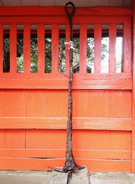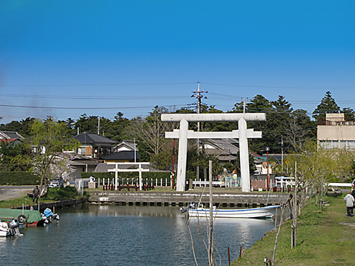

現地の息栖神社では不覚にもこの「碇」の存在に気付かず、説明板のついでに周辺を撮影した写真から今回いちばん上の写真を拡大・編集してみた。よく文章を読んでみたらこの目立たない「碇」が重要な役回りで港(津)であったこの息栖の地の素性を表していたことにあとで気付かされた。
どうも「息栖」という漢字表記の地名は一般的な日本語感覚からは想像しにくい。息という字はまさか地名とは思わず、つい「鳥」と無意識に見間違えて「とりす、かなぁ。ウイスキーみたいだ」というような無用な妄想誤解がアタマのなかに浮かんで収拾がつかない(笑)。
こういうのはわたしだけではなく多くの人がそう思うようです。
一方で「おきすの津」と古代に呼ばれていた地名はよくわかる。ストンと腑に落ちてくる表現。ではどうして「おきす」が「息栖」になったのか、調べてみても情報に巡り会えない。
そういう不条理感から、どうも地名に「海民」的な、原初的日本人言語感が投影されているのではないかと妄想が飛躍したりする。古日本語的な言語感覚があるようにも思えるのですね。この感覚は飛鳥地方とか、徳島県の山岳地域などにも通じるようなもの。その後の日本語は活発な「漢字文化」の導入によってその「音読み」「意味づけ」が主流になっていったのに対して、オリジナルな日本語の感受性を伝えてくれていると思えるのです。
さらに、一説ではこの東国三社とは、ヤマト王権以前に関東〜東北に存在したとされる「日高見〜ひだかみ〜国」の根拠地に相当するのではないかとも言われる。
北海道にいるとアイヌ語由来の地名が非常に多いけれど、そういう言語感覚にも通底しそうな表現の仕方が投影されているとも思えてくる。

いずれにせよ、古関東の内海の港(津)であった息栖に関連して日本列島の国内各地間の太平洋側海上ルートを探ってみるけれど、なかなか明示的研究に突き当たらない。この息栖神社の解説説明板には以下の記述。
「徳川期になると幕府の拠点江戸と東北との交流が盛んになりその水上輸送路は、江戸川・利根川・水郷地帯・銚子河口から北上しての鹿島灘といった航路が選ばれていた。こうした長距離輸送には当然大型船舶が用いられ、往復途上で息栖神社は航海の安全祈願をしたとされる。」(要旨抜粋)
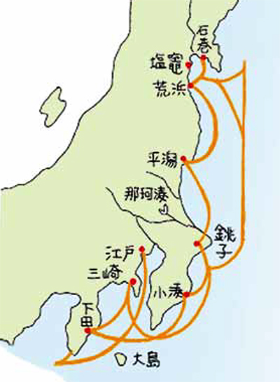
上の図は江戸期に消費都市江戸に20万石ほどの米を提供したといわれる仙台藩の安定的輸送ルートを諮問された先端的事業家・河村瑞賢が開拓した「東回り航路」図。<こちらは宮城県の公式資料「河村 瑞賢 -東廻り航路を拓く」より引用>
「これまでの海運では船が難破することが多い。仙台藩から江戸に到着するのに1年かかることすらある。」と相談されたかれが開発した。
しかし、奥州藤原氏の時代には愛知県常滑の磁器が威信材として、遠く北海道・厚真でも発掘されている。たしかに日本海側が国内物流の基本ではあったでしょうが、熊野水軍など太平洋側の物流輸送活動実態もある。海路の日本史、非常に奥行きのある世界だと思います。
English version⬇
Okisu ⇒ Ikisu & Domestic Shipping History, Ikisu Shrine (3): Exploration of Three Shrines in Eastern Japan – 23
Japanese History of Language Sense Transition. Is it a residue of the ancient Yamato language? What about the development process of domestic sea routes on the Pacific Ocean side from ancient times? The history of domestic maritime transport in Japan
I was unintentionally unaware of the existence of this “anchor” at the local shrine, so I enlarged and edited the top photo from the photos I took of the surrounding area while reading the explanatory board. After reading the text carefully, I realized later that this inconspicuous “anchor” played an important role in the identity of this place, which used to be a port (Tsu).
It is difficult to imagine a place name written in kanji characters as “breath” in the common Japanese sense. I did not think that the character for “breath” was a place name, and I unconsciously mistook it for “bird” and said, “Torisu, I wonder. It sounds like whiskey.
(Laughs.) This is not only me, but many people seem to think so.
On the other hand, I understand the name of the place called “Okisu-no-tsu” in ancient times. It is an expression that falls into place. But when I tried to find out why “Okisu” became “Ikisu,” I could not come across any information.
This sense of absurdity leads me to wonder if the place name might reflect a primitive Japanese linguistic sense like that of the “Kaimin” people. It seems to me that there is an old Japanese linguistic sense. This sense is something like that of the Asuka region or the mountainous areas of Tokushima Prefecture. It seems to me that it conveys an original Japanese sensibility, whereas the Japanese language since then has been dominated by its “sound reading” and “meaning making” with the introduction of an active “kanji culture.
Furthermore, one theory suggests that these three shrines in the eastern part of the country may correspond to the border line with the “Hidakami – Hidakami – Province,” which is said to have existed in the Kanto – Tohoku region before the Yamato Kingship.
In Hokkaido, there are many place names derived from the Ainu language, and I cannot help but think that such a way of expression that seems to be common to such linguistic sensibilities is also projected here.
In any case, I have been searching for maritime routes between the Japanese archipelago and other parts of Japan in relation to the ancient Kanto inland sea port (Tsu) of Suisu, but have been unable to come across any explicit research on the subject. The explanatory board at the shrine reads as follows.
The Edo River, the Tone River, the Suigo area, and the Kashima Sea route northward from the mouth of the Choshi River to the Kashima Sea were chosen for the water transportation routes. Naturally, large vessels were used for such long-distance transportation, and it is said that the shrine prayed for safe voyages on the way there and back. (Abstract excerpt)
The above chart shows the “eastbound route” pioneered by Kawamura Zuiken, a leading entrepreneur who was consulted on a stable transportation route by the Sendai clan, which is said to have supplied the consuming city of Edo with some 200,000 koku of rice during the Edo period. In the past, ships were often shipwrecked in shipping. It sometimes takes a year for a ship to reach Edo from Sendai. Takara, who was consulted by the Oshu Fujiwara clan, developed the map.
However, during the reign of the Oshu Fujiwara clan, porcelain from Tokoname, Aichi Prefecture, was excavated as prestige material, as well as in Atsuma, Hokkaido in the distant past. It is true that the Sea of Japan side was the basis of domestic distribution, but there were also activities on the Pacific side, such as the Kumano Suigun (navy). The history of Japan by sea is a world of great depth.
Posted on 8月 28th, 2023 by 三木 奎吾
Filed under: 日本社会・文化研究, 歴史探訪


コメントを投稿
「※誹謗中傷や、悪意のある書き込み、営利目的などのコメントを防ぐために、投稿された全てのコメントは一時的に保留されますのでご了承ください。」
You must be logged in to post a comment.