
「日本列島の最北」というようにわたしたち戦後の日本人は稚内への意識が形成されているけれど、この地で封印されている地域史を実地学習すると、いかにここが樺太開拓と密接に関係した地域であるかがわかってくる。きのうは9人の女子が樺太の地で終戦後5日の時点で無惨な最期を遂げたことに触れたけれど、そこからも北海道と樺太の深いつながりが地低音のようにこころに響き渡ってくる。
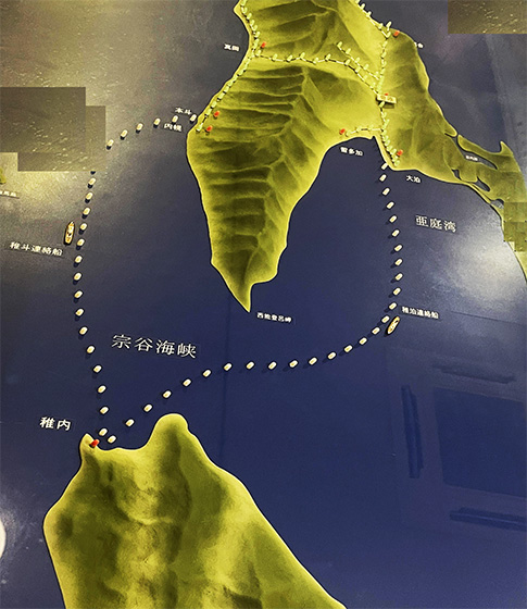
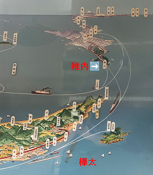
日本最北と稚内を認識しているけれど戦前の日本人にとって稚内は、樺太開発開拓の最前線連絡港。明治維新の頃の函館-青森のような認識が一般的だったのだと。とくに稚内は冬期には流氷が接岸することで船の航路が影響を受けるオホーツク海側の港町とは違って、北海道最北だけれど日本海側に面していて「不凍港」として貴重な存在だったのだ。戦前には総人口40万人を超えたとされる樺太とその領土経営は、政治・軍事・経済のすべてにおいて北海道・稚内と不可分に結びついていたのだ。ちなみに現在の稚内人口は約3万人ほど。こういう樺太との経済社会関係を想像すれば、そうかと、さまざまに気付けることがある。
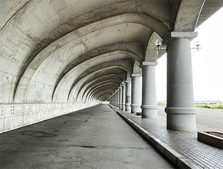
現在青森は青函連絡船が廃止されたのでその港湾としてのにぎわいは減少してきているけれど、函館にはまだそういう国土・国民の流動拠点の文化が色濃く残っている、稚内はそういった機能を本来的に宿命づけられた都市なのだと言える。その建築的遺構がこちら。2番目の写真はいまも残る稚内を象徴する建築である「防波ドーム」だけれど、これは稚内から樺太への航路の駅舎(現在は解体されている)への通路を波濤から守る役割のために造作されたもの。
地理的な位置関係でも稚内までの鉄道駅舎から徒歩でも10数分でたどりつける港湾施設だった。戦前社会までの活発な「人流・物流」の機能が容易に想像できる。わたしたち戦後社会はこうした「人間社会文化」を忘却し続けているのだと深く驚かされる。というか、それはあり得べき必然でもある。用はすべてを決定づける。
稚内の都市の基底にこういう港湾人流機能文化は根深く眠っている。
●お知らせ
拙書「作家と住空間」幻冬舎から電子書籍で発刊
お求めはAmazonで。
https://amzn.asia/d/eUiv9yO
English version⬇
Prewar and Postwar / Transformation of Japanese Consciousness Hokkaido to Karafuto]
Wakkanai, an ice-free port city straddling the Soya Strait, which is easier to navigate than the Tsugaru Strait. Karafuto is the front line of new development of the Japanese people. Wakkanai is the starting point of the main artery. The city of Wakkanai is the starting point of a major artery for the new development of the Japanese people.
We postwar Japanese have formed a consciousness of Wakkanai as “the northernmost of the Japanese archipelago.” However, when we learn about the local history sealed off in Wakkanai, we realize how closely connected this area was to the development of Sakhalin. Yesterday I mentioned that nine girls died tragically in Sakhalin five days after the end of the war, and the deep connection between Hokkaido and Sakhalin resonates in our hearts like a low earth tone.
Although Wakkanai is recognized as the northernmost point in Japan, for prewar Japanese, Wakkanai was a frontline port for the development of Sakhalin. It is said that the perception of Wakkanai was similar to that of Hakodate-Aomori at the time of the Meiji Restoration. In particular, unlike port towns on the Sea of Okhotsk, which were affected by drift ice in winter, Wakkanai faced the Sea of Japan even though it was the northernmost port in Hokkaido, and was valuable as an “ice-free port. Karafuto, with a total population of over 400,000 before the war, and its territorial management were inseparably linked to Wakkanai, Hokkaido, in all aspects of politics, military affairs, and economics. Incidentally, the current population of Wakkanai is about 30,000. If we imagine this kind of economic and social relationship with Karafuto, we can notice many things.
Today, Aomori’s bustle as a port has decreased since the Aomori Hakodate ferry was abolished, but Hakodate still retains a strong culture of being a hub for the flow of land and people, and Wakkanai is a city inherently destined for such functions. The second photo shows the “wave breaker dome,” a symbolic structure that still remains in Wakkanai, which was built to protect the passageway to the station building (now demolished) for the route from Wakkanai to Sakhalin from the waves.
In terms of geographical location, it was a port facility that could be reached in 10 or so minutes on foot from the railroad station building to Wakkanai. It is easy to imagine the function of active “human flow and logistics” in prewar society. I am deeply surprised that our postwar society continues to forget such “human social culture. Or rather, it is an inevitability. Usage determines everything.
This kind of culture of the port human flow function is deeply rooted in the foundation of Wakkanai city.
I am now publishing my book “Writers and Residential Space” as an e-book from Gentosha.
Please visit Amazon.com for more information
共有:

Posted on 7月 22nd, 2025 by 三木 奎吾
Filed under: 日本社会・文化研究, 歴史探訪


コメントを投稿
「※誹謗中傷や、悪意のある書き込み、営利目的などのコメントを防ぐために、投稿された全てのコメントは一時的に保留されますのでご了承ください。」
You must be logged in to post a comment.