
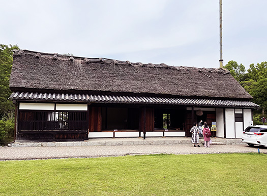
旧臼井家住宅(国指定重要文化財)
母屋/切妻造茅葺き 桁行9間 梁間3間
二面庇付き本瓦葺き
内蔵/土蔵造り本瓦葺き 2階建て
奈良県をよく旅するようになって気付くのは
奈良県というのは南部の多くが山岳地帯であり、その山並みに区切られた
盆地の最北部に「奈良市」があって、やがて京都に都が
移転していく歴史経緯を考えると平野部南端から徐々に「北上」した
そういうやまとの国の流れというものを感じることができる。
纏向は盆地のやや東端部にあるけれど、そこから一旦、王権は南下して
飛鳥の地にとどまり、その後藤原京の造営から北上が開始され
平安京奈良の大都市造営が時代を画していって、
やがて京都に大きく飛躍して移転したという経緯かと。
そういうなかにあってこの住宅が建てられたのは江戸期、約300年前という。
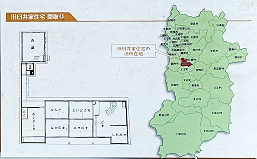
3番目の間取り・地図では奈良県の北西側と見えるけれど、
おおむねの地理感覚はこのように規定できる。
奈良県地域は南都として宗教勢力が異常なパワーを持っていて
鎌倉〜戦国期から江戸期の武士の時代でも
なかなか治めにくい地域だったことは疑いないと思う。
豊臣期には京大阪を押さえた秀吉政権の後背地域として
秀吉の弟、大納言秀長が押さえ、さらに後背の紀州までも彼が統治した。
秀長にしても南都奈良を避けて、その隣接の大和郡山を拠点とした。
そういう武権統治の難しい地域だったと言われる。
明日香村と橿原市と隣り合う「高取」には城が築かれ
江戸期には「高取藩」が最盛期石高10万石で営まれていた。
はじめは秀長の系統の家臣出自の大名が支配したが
やがて徳川氏の家臣が親藩として支配するようになったという。
植村氏という士族が、幕末には尊皇派として活動し
明治になっても無事に家を持ちこたえ続けていたという。
この「旧臼井家」住宅は、その高取城の城下町の大手街道に面して
藩の「公用伝馬」の役を務めるかたわら、酒・醬油販売を行って繁盛し
城下町の「大年寄」を務めていた家柄だという。
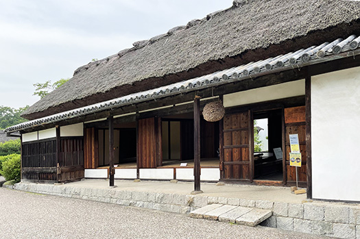
きのうはこの家の土間に鎮座する「おくどさん」をクローズアップした。
この家は左側の2間を商家ふうの「格子構え」としながら、
いかにも農家風の平面と外観を持っているとされる。
高取藩は奈良盆地から吉野に向かう旧街道に面していて
純粋な商業地域では無いけれど
基本は農業地帯でありながら街道筋としての商業的性格もあった、
というような街区の性格を表現した住宅と思います。
シンプルな機能性に従った簡素な姿カタチが美しい。
English version⬇
A “Half Trader, Half Farmer” Townhouse under the Former Takatori Domain Castle, Yamato Historical Testimony-18
The Nara Basin has a different regional character from the active Kyoto-Osaka economic zone. A blend of farmhouse and merchant-style lattice design. Simple functional appearance. The house is a mixture of…
Former Usui Family Residence (Designated by the national government as an important cultural property)
Main house / Gabled roof with thatched roof, 9 ken (girder length), 3 ken (beam length)
Tile roof with eaves on two sides
Gut: 2 stories, earthen storehouse style, tile roofing
As I travel around Nara Prefecture more and more, I notice that
Nara Prefecture is a mountainous region in the southern part of the prefecture, and the northernmost part of the basin is called “Nara-bon”, which is separated by the mountain range.
The city of Nara was located in the northernmost part of the basin, and the capital was eventually moved to Kyoto.
The capital was eventually relocated to Kyoto, and the history of Nara shows that the capital gradually moved northward from the southern edge of the plain.
The city of Mimamukai is located on the eastern edge of the basin.
Mato-mukai is located in the eastern part of the basin, but once there, the royal power moved southward to Asuka, and then moved northward to Kyoto.
The royal power once moved southward to Asuka, and then began to move northward with the construction of the Fujiwara-kyo capital.
The construction of the Heian-kyo and Nara-kyo metropolises marked the era.
The construction of the Heian-kyo and Nara-kyo metropolises marked the era, and eventually, the capital moved to Kyoto in a great leap forward.
It is said that this house was built in the Edo period, about 300 years ago.
The third floor plan and the map show the house on the northwest side of Nara Prefecture.
The third floor plan and map shows the area to the northwest of Nara Prefecture, but the general geographical sense of the area can be defined as follows
The Nara area, as the southern capital of Japan, was an area where religious forces had unusual power.
Even during the Kamakura, Sengoku, and Edo periods, it was a very difficult area to govern.
There is no doubt that it was a difficult region to govern even during the Kamakura, Sengoku, and Edo periods.
During the Toyotomi period, the area was the hinterland of Hideyoshi’s government, which controlled Kyoto and Osaka.
In the Toyotomi period, the area was ruled by Hideyoshi’s younger brother, Dainagon Hidenaga, who also ruled Kishu, which was located behind Hideyoshi.
Hidenaga also avoided Nara, the southern capital of Japan, and used Yamatokoriyama, adjacent to Nara, as his base of operations.
It is said to have been such a difficult region to govern by military authority.
A castle was built in Takatori, which is adjacent to Asuka Village and Kashihara City.
In the Edo period, the Takatori clan was at its peak, with a total of 100,000 koku in stone.
At first, it was ruled by feudal lords from the line of Hidenaga’s vassals.
Eventually, vassals of the Tokugawa clan came to rule as the parent clan.
A warrior clan called the Uemura clan acted as the Emperor’s faction at the end of the Edo period, and
The family continued to hold on to their house safely even after the Meiji period.
This “old Usui Family” house is located facing the Ote Highway in the castle town of Takatori Castle, and is said to be the residence of the clan’s “official messenger”.
While serving as the clan’s “official messenger,” the family also sold sake and shoyu, and prospered as the “Oenyoyomi” of the castle town.
The family was said to have been the “Oenyoro” of the castle town.
Yesterday, I took a close-up look at the “okudo-san” that sits on the earthen floor of the house.
The two rooms on the left side of the house are latticework in the style of a merchant house.
The house is said to have a “lattice structure” in the style of a merchant house between the two rooms on the left side, while having a farmhouse-like plan and appearance.
The Takatori domain faces the old highway from the Nara basin to Yoshino.
It is not a purely commercial area.
It is not a purely commercial area, but it is basically an agricultural area, but it also had a commercial character as a highway.
The house seems to express the character of the district.
The simple form of the house, which follows simple functionality, is very beautiful.
共有:

Posted on 7月 14th, 2022 by 三木 奎吾
Filed under: 住宅取材&ウラ話, 歴史探訪


コメントを投稿
「※誹謗中傷や、悪意のある書き込み、営利目的などのコメントを防ぐために、投稿された全てのコメントは一時的に保留されますのでご了承ください。」
You must be logged in to post a comment.