
紀州という北海道在住者からすると現代でもあまり縁の近くない地域。
たまたま家系伝承である起点になっている経緯に導かれて深掘りしてきました。
そのテーマについては非常にか細い手掛かり段階で
これからできるだけ事実の痕跡を確認していきたいと思います。
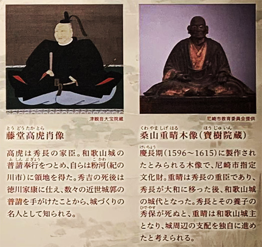
とくに2枚目の写真の藤堂高虎、桑山重晴の時代がキーポイントかと。
しかしそのようなピンポイント探索でも調査範囲は広く深くする必要がある。
必然的に紀州の総体についてあれこれの角度から探っていく考えです。
過程ではわかやま城歴史館で学芸員の方とお話しできるなど
深掘りの手掛かりはさまざまに得られた次第。
現代は過去のどの時代よりもWEBの発達などでピンポイント探索が可能。
たかだか400年ちょっと前の事実なのでそれくらいの時間経過は
これから以降の時代には相当に全体把握が可能になると思われます。
人間社会はリレーランニングという進化構造。
いま生きている人間は、その探索に全力を尽くすことで
これから先の人々に知恵を伝承していくことができる。
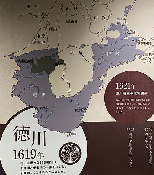
紀州の「地政学」という視点はあまり考えてこなかったし、
断片的理解だったのですが、この説明図で巨視的な視点に気付かされた。
江戸期になぜ紀州に御三家が置かれたのかがわかるし、
また近畿圏にとって紀州の存在もよく見える図面。
奈良県の山岳地帯を含めて考えると紀州は近畿の巨大な自然資産。
最南端にちかい熊野が占めている宗教的位置が象徴的。
そしてこの地図からは伊勢神宮までそのコントロール下に置いている。
朝廷が歴世尊崇してきた地域を支配下にしている。
そして紀州徳川家の版図として尾張徳川家と連携して
京大阪の大人口集積地をコントロールする地政学的位置。
またその尾張の先には徳川氏の本願の地である静岡があって
江戸を望んでいるといえる。家康の列島支配権力構造の中では
こういった環太平洋型の戦略構造が存在したように思われる。
家康は頼朝を先達として尊崇したとされるけれど、
鎌倉と江戸とを繋ぐ「統治原理」のような戦略性を感じる。
そういうなかで中心都市の和歌山は関西圏の瀬戸内海海運に参加するとともに、
ここを起点としての紀伊水道〜太平洋航路の重要拠点。
江戸期の紀伊国屋文左衛門が江戸の大火後、再建資材として木材出荷で
巨利を得たというのは、この「太平洋航路」利用という側面が
大きかったのだろうと思われる。
江戸期前までは瀬戸内海海運が大動脈であり、
比較的に波の穏やかな日本海海運によって北海道も含めた物流ネットワークが
日本社会の「オモテ」だったのだろう。
さて、次回以降の探索に向けて地道にできることを継続したい。
English version⬇
Kishu’s Geopolitics: Exploring Nara and Wakayama – 33
Ieyasu’s strategy to dominate the Pacific Belt region of Kishu. The contrast between the traditional Japanese social system centered on trade on the Seto Inland Sea and the Sea of Japan. …
Kishu, a region that even today is not so closely related to Hokkaido from the perspective of a Hokkaido resident.
I have been digging deeper, guided by the history that happens to be the starting point of a family tradition.
We are still at the stage of very faint clues on the subject.
I would like to confirm the traces of facts as much as possible from now on.
In particular, the period of Takatora Todo and Shigeharu Kuwayama in the second photo may be the key point.
However, even in such a pinpoint search, the scope of investigation needs to be broad and deep.
Inevitably, we would like to explore Kishu as a whole from various angles.
In the process, I could talk with the curator at Wakayama Castle History Museum, etc.
I was able to get various clues to dig deeper.
Today, the development of the Internet and other means has made it possible to do more pinpoint searches than at any other time in the past.
The fact that it is only a little more than 400 years old means that the passage of time is
It will be possible to grasp the whole picture in the future.
Human society is an evolutionary structure of relay running.
People who are alive today will do their utmost to search for it.
We can pass on our wisdom to those who will come after us in the future.
I had not given much thought to the “geopolitical” perspective of Kishu, and
It was a fragmented understanding, but this illustration made me realize the macroscopic viewpoint.
I now understand why the Gosanke were located in Kishu during the Edo period.
The drawing also clearly shows the existence of Kishu for the Kinki region.
Kishu, including the mountainous areas of Nara Prefecture, is a huge natural asset of the Kinki region.
The religious position of Kumano, which is near the southernmost point, is symbolic.
The map also shows Ise Shrine under its control.
The Imperial Court has controlled the area that has been revered and respected for generations.
And as a version of the Kishu Tokugawa family, in cooperation with the Owari Tokugawa family, they control a large population center in Kyoto and Osaka.
The geopolitical position to control the large population center of Kyoto-Osaka.
The Owari region is located in Shizuoka, which is the main desire of the Tokugawa clan.
Edo, the capital of the Tokugawa clan. In Ieyasu’s power structure to control the archipelago
Ieyasu’s power structure for controlling the archipelago seems to have been a Pacific Rim-type strategic structure.
Ieyasu is said to have respected Yoritomo as his predecessor.
I feel the strategic nature of the “ruling principle” that connects Kamakura and Edo.
In this context, Wakayama, the central city, participated in the Seto Inland Sea shipping of the Kansai region.
Wakayama is an important base for shipping routes between the Kii Channel and the Pacific Ocean, and also participates in the Seto Inland Sea shipping routes in the Kansai region.
It is said that Kinokuniya Bunzaemon in the Edo period earned a huge profit by shipping lumber as materials for rebuilding after the Great Fire of Edo.
The fact that Kinokuniya Bunzaemon earned a huge profit by shipping lumber as materials for rebuilding after the Great Fire of Edo is thought to have been due in large part to the use of the Pacific Ocean route.
The fact that Kinokuniya Bunzaemon made a huge profit by shipping lumber to rebuild after the Great Fire of Edo (1603-1868) is thought to have been due in large part to the use of the Pacific Ocean route.
Until the Edo period, the Seto Inland Sea was the main artery of shipping.
The Japan Sea, with its relatively calm seas, provided a logistics network that included Hokkaido.
The Japan Sea shipping network, which included Hokkaido, was the “Omote” of Japanese society.
Now, we would like to continue what we can do steadily for the next and subsequent explorations.
共有:

Posted on 5月 21st, 2022 by 三木 奎吾
Filed under: 日本社会・文化研究, 歴史探訪


コメントを投稿
「※誹謗中傷や、悪意のある書き込み、営利目的などのコメントを防ぐために、投稿された全てのコメントは一時的に保留されますのでご了承ください。」
You must be logged in to post a comment.