
本日は閑話休題。古民家をちょっと離れて現代の北海道小ネタ。
札幌という街は、明治の開拓と同時に開かれ始めた都市。
まだ150年くらいの歳月しか刻んでいない。
人口規模は北海道の4割近くにまで急増してきているけれど、
根っからの札幌人、土地の人間というのは江戸・東京と同様に
まだまだ多くはないと言えるでしょう。
まぁよく言われた「リトルトーキョー」というのがピッタリ。
わたしは3歳からの札幌人、一時期東京生活があったけれど、
おおむね60年程度の居住時間があります。
そういう人間ですが最近まで「札幌岳」という山を知らなかった(笑)。
札幌は方位的に南側が大きく山岳地帯に囲まれている。
この山岳地帯から石狩平野に向かって扇状地形が広がり、
その山裾のやや高地に札幌の街は展開している。
で、札幌で山と言えば藻岩山・円山・三角山がポピュラーで、手稲山が
市内中心部からはやや離れているけれど高さ的にはいちばんという認識。
わたしの散歩道は円山の麓の北海道神宮周辺であり、やや西部の三角山とが
日常感覚ではごく身近で季節感を見せてくれる存在です。
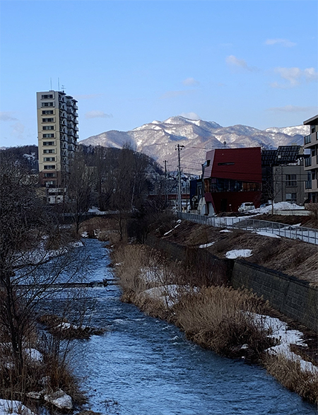
ところが最近、早朝散歩などで趣向を変えてあちこち歩いていて
南に向かい左手三角山、右手手稲山のほぼ中間方向に高い山を見続けている。
やや遠景なのですが、手稲と遜色のない高さを感じられる。
で、この写真の山の名が「札幌岳」なのであります。
先日、この山が見晴らせる通りをクルマを走らせていて
カミさんに「札幌岳」と告げても札幌居住歴わたしとほぼ同様の彼女も
「なにそれ???」という状態。「へえ〜〜〜」

地図で表現するとこのような位置関係。
札幌岳という名前ですが、山頂位置は札幌市中心部から恵庭市同等の距離なので
眺めることは上の写真のように可能だけれど、登ったりするのは
山男・山女でもなければ気軽に登山というようにはならない。
命名の由来は「札幌市の南西部、定山渓温泉の南にある。札幌市を流れる
豊平川はもともとアイヌ語でサッポロ川「水の涸れている大きな川」の意味で、
その上流にある山なので札幌岳の名が冠せられている」。標高 1,293m。
ちなみに手稲山は1023.1m。藻岩山531m、三角山311.3m、円山225m。
都心とはやや離れる手稲山もいいスキー場があって身近。
札幌市街地に近接する藻岩山以下の山々は市民もよく出掛けるし、それこそ
すぐにも登れる気安さがあり、また円山はとくに自然保護林にもなっている。
円山は明治の開拓初期、島義勇開拓判官が市域全域を見渡して
大きく「街割り」したとされる歴史にも名が刻まれる存在であり、
なんといっても北海道神宮が仮の居場所から正式に遷座された聖地。
そういう山々と比べて、高さが超飛び抜けているワケでもないなかで、
名前だけ「札幌岳」と聞かされても、なかなか馴染みが深まらないのですね。
まぁ山に悪気はないのですが、といったところ。
しかし「札幌岳」なので、これからも国際的に発展して欲しい市民としては
どうしたらもっと親しめる山になっていけるのか、
未来を担う若い人たちにわたしらがやらねばならない仕事のようにも思える。
せっかくいい名前を付けているのでそれを生かすべきだ。
逆に言うと先人のみなさんから「おい、なんか知恵を出せや」と
お叱りをいただいているようにも思います(笑)。う〜む。
English version⬇
[Mt. Sapporo, which most Sapporo people do not know]
Quiet talk today. A little away from the old folk house, a modern Hokkaido small story.
The city of Sapporo is a city that began to open at the same time as the development of the Meiji era.
Only about 150 years have passed.
Although the population scale has rapidly increased to nearly 40% of Hokkaido,
The people of Sapporo and the people of the land are the same as in Edo and Tokyo.
It can be said that there are not many yet.
Well, the well-known “Little Tokyo” is perfect.
I’m a Sapporo person from 3 years old, I lived in Tokyo for a while,
I have a living time of about 60 years.
I’m such a person, but until recently I didn’t know the mountain called “Mt. Sapporo” (laughs).
Sapporo is directionally large on the south side and is surrounded by mountainous areas.
An alluvial fan spreads from this mountainous area toward the Ishikari Plain.
The city of Sapporo develops in the highlands at the foot of the mountain.
So, speaking of mountains in Sapporo, Mt. Moiwa, Mt. Maruyama, and Mt.
Although it is a little far from the city center, it is recognized as the tallest.
My walking path is around Hokkaido Shrine at the foot of Maruyama, and there is a slightly western part of Sankakuyama.
In everyday life, he is very familiar and shows a sense of the seasons.
However, recently, I changed my mind by taking a walk in the early morning and walking around.
Heading south, we continue to see high mountains in the middle of Mt. Sankaku on the left and Mt. Teine on the right.
It’s a little distant view, but you can feel the height comparable to Teine.
Teine is a relatively close mountain, so in contrast it feels far and still high.
So, the name of the mountain in this photo is “Mt. Sapporo”.
The other day, I was driving a car on the street overlooking this mountain
Even if I tell Kami “Mt. Sapporo”, she has lived in Sapporo and is almost close to me.
“What is that ???” “Hey ~~~”
This kind of positional relationship can be expressed on a map.
The name is Mt. Sapporo, but the location of the summit is the same distance as Eniwa City from the center of Sapporo City.
You can see it as shown in the picture above, but you can climb it.
If you are not a mountain man or a mountain woman, you cannot easily climb a mountain.
The origin of the name is “Southwest of Sapporo City, south of Jozankei Onsen, and the north side of the summit.
It is a steep cliff with a deep cut. The Toyohira River, which flows through Sapporo, was originally in Ainu.
Sapporo River It means “a big river with water” and it is a mountain upstream of it.
It bears the name of Mt. Sapporo. The reason. Altitude: 1,293m.
By the way, Mt. Teine is 1023.1m. Mt. Moiwa 531m, Mt. Sankaku 311.3m, Mt. Maruyama 225m.
Teineyama, which is a little far from the city center, has a nice ski resort and is close to us.
Citizens often go out to the mountains below Mt. Moiwa, which is close to downtown Sapporo.
It is easy to climb immediately, and Maruyama is especially a nature protection forest.
In Maruyama, in the early days of the Meiji era, Yoshitake Shima, a pioneer judge, overlooked the entire city area.
It is an existence that is engraved in the history that is said to have been largely “divided into land”.
After all, the sacred place where Hokkaido Shrine was officially relocated from its temporary location.
Compared to such mountains, the height is not so high,
Even if you hear only the name “Mt. Sapporo”, it’s hard to get used to it.
Well, there is nothing wrong with the mountains, but that’s the place.
However, since it is “Mt. Sapporo”, as a citizen who wants to continue to develop internationally
How can we become a more familiar mountain?
It seems like a job we have to do for the young people who will bear the future.
I have given it a good name, so I should make use of it.
To put it the other way around, the ancestors said, “Hey, give me some wisdom.”
I think you’re being scolded (laughs). Hmmm.
共有:

Posted on 3月 26th, 2021 by 三木 奎吾
Filed under: 「都市の快適」研究, 日本社会・文化研究


コメントを投稿
「※誹謗中傷や、悪意のある書き込み、営利目的などのコメントを防ぐために、投稿された全てのコメントは一時的に保留されますのでご了承ください。」
You must be logged in to post a comment.