
さて、昨日友人からの連絡で、無事に鹿島神宮にて紛失のSUICAカードの手続き関係が完了し、北海道札幌のわたしのもとまで郵送される手配が終わったと知らせを受けました。段々加齢と共に、こういう機縁でいただく人からの情に深く癒されるモノを感じてしまいます。ほんの小さな体験、それも自身の不注意による紛失が多くの人の善意によって解決されたことに、金銭のことではなく、感謝の念が強くなっています。
たまたまReplanとして「関東版」の出版を8月に予定していて、地の神へ身をただしてごあいさつするみたいな、そういった心理も持っていた次第であります。
そしてブログを書き進めていて、利根川東遷という江戸期の土木大事業が与えたインパクトも掘り起こさせていただき、その利根川が鹿島神宮の位置する茨城県と千葉県の境界地域の太平洋岸に流れていくということからも、自然な導きの「ながれ」を感じてもおりました。
北海道の歴史好き人間として、関西・畿内の奈良県古代の王権成立地域と並んで、徐々にこの関東平野地域の歴史の底流を探索する志向性も高くなってくる。
そういうことでかねてから強い興味を持っていた鹿島神宮のことを謹んで探索したいと思います。
住宅雑誌人としては、まずは巨視的な「地形」「位置関係」に興味が向かいます。
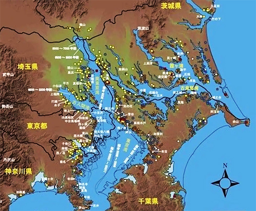
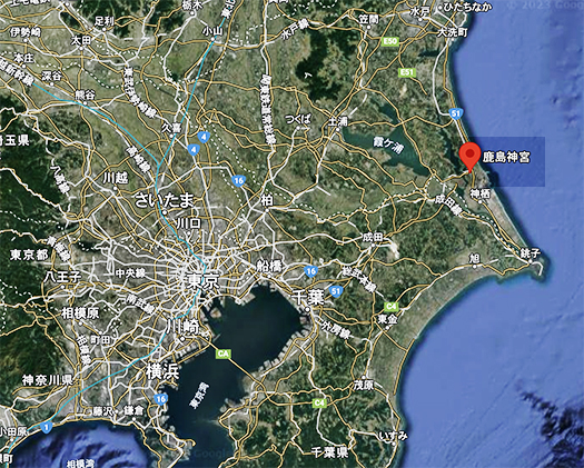
いちばん上の地形図は、江戸東京博物館から2021年に発出された「縄文時代の関東地形図」です。江戸東京博物館によるとこの図は2021年12月5日まで開催中の特別展「縄文2021―東京に生きた縄文人―」の展示パネル等に使用するため作成したものだという。薄く点線で現在の地形が示されている。下には現代地図を比較させた。
よく香取の海、という表現がされるようにこの地域は縄文海進によって多くの「貝塚」が形成される地域だったのだという。このような地形記憶が連綿と関東人の知識として伝承されて、それまで江戸湾・東京湾に注いでいた利根川の「東遷」計画という事業の構想が浮かんできたのでしょうか。

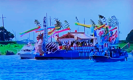
現代でも鹿島の位置を明瞭に示す御船祭祭礼。「鹿島神宮の例祭は毎年9月1日に行われますが、うち6年に一度は天皇陛下の御使である勅使が派遣される勅祭となり、さらにそのうち2回に1回、すなわち12年に一度の午年には、水上の一大祭典である御船祭も斎行されます」という民族記憶継承のような行事も行われてきている。
この鹿島という地域の立地性について古代人の素朴な自然崇拝を下敷きにして考えてみれば、列島全体から見ての「東の涯」という太陽神信仰に素朴に合致しているように思える。太陽はこの地域から昇ってくる。古地形をアタマに入れてみるとその島状地形を「仰ぎ見る」位置から太陽が上がっていくことになる。
列島に住み暮らした縄文、あるいはそれ以前からの人びとにとって、こういう自然地形位置というのに対して「神宿る」と捉えることはごく当然だったに違いない。大和平野地域に対する伊勢の位置とも通じるような印象も強く持たされる。
English version⬇
Topographical Changes in the Kanto Region and the Location of Kashima Shrine: Exploring the Three Shrines of Eastern Japan-1
Kashima Shrine is located in a place where “gods dwell” that has settled in the hearts of Kanto people since the Stone Age and Jomon period. Does the simple belief in the sun god inspire the people of the archipelago? ……
Yesterday, I received a call from a friend informing me that the procedures for my lost SUICA card had been completed at Kashima Jingu Shrine and that arrangements had been made for the card to be mailed to me in Sapporo, Hokkaido. As I get older, I feel more and more deeply comforted by the kindness I receive from people through such opportunities. I am feeling more and more grateful, not for the money, but for the fact that a small experience, a loss caused by my own carelessness, was resolved by the goodwill of so many people.
It just so happens that the publication of the Kanto edition of Replan is scheduled for August, and I had a feeling like bowing to the gods of the land and greeting them.
In the course of writing this blog, I was also able to discover the impact of the Tone River’s eastward shift, a major civil engineering project in the Edo period, and felt a natural “flow” of guidance from the fact that the Tone River flows to the Pacific coast of the border area between Ibaraki and Chiba prefectures where Kashima Jingu Shrine is located.
As a history buff from Hokkaido, I have gradually become more inclined to explore the history of the Kanto Plain region, along with the ancient royalty-establishing areas of Nara Prefecture in Kansai and Kinai.
With this in mind, I would like to respectfully explore Kashima Jingu Shrine, which I have had a strong interest in for some time.
As a residential journalist, my interest first turns to the macroscopic “topography” and “location.
The topographic map at the top is the “Topographic Map of Kanto in the Jomon Period” published by the Edo-Tokyo Museum in 2021. According to the Edo-Tokyo Museum, this map was created for use in the exhibition panels of the special exhibition “Jomon 2021: Jomon People Living in Tokyo,” which will be held until December 5, 2021.
As often expressed by the expression “Katori no Umi” (Katori sea), this area was the site of many “shell mounds” formed by the Jomon sea advance. This topographical memory has been handed down as knowledge to the Kanto people, which may have inspired the idea of a project to “eastward shift” the Tone River, which had previously flowed into Edo Bay and Tokyo Bay.
The Mifune Matsuri festival clearly shows the location of Kashima even today. The annual festival of Kashima Jingu Shrine is held on September 1 every year, and once every six years an imperial envoy is dispatched to the shrine to perform the festival.
If we consider the location of this region of Kashima, based on the simple nature worship of the ancients, it seems to be in simple accord with the belief in the Sun God as the “eastern horizon” of the entire archipelago. The sun rises from this region. If we take the ancient topography into consideration, the sun rises from a position that “looks up” at the island-shaped topography.
For the Jomon and earlier people who lived on the archipelago, it must have been natural for them to consider the position of such natural landforms as a “dwelling place of the gods. The location of Ise in relation to the Yamato Plain area also gives a strong impression.
Posted on 8月 5th, 2023 by 三木 奎吾
Filed under: 住宅マーケティング, 日本社会・文化研究


コメントを投稿
「※誹謗中傷や、悪意のある書き込み、営利目的などのコメントを防ぐために、投稿された全てのコメントは一時的に保留されますのでご了承ください。」
You must be logged in to post a comment.