
わたしたち現代人はいま見えている地形環境で歴史も想像する。
しかし、東京の地は家康の入部以来、旺盛な土木改編が加えられてきている。
水田農耕とは土地を人為的に改造することが基礎技術。
そしてその技術発展は人類史の中でも日本列島で巨大な成功を収めた。
四季変化が明瞭でとくに梅雨などの長雨が恒常化している国土では
こうした河川管理技術というのは権力の最高レベルの権威基盤。
卑弥呼のように呪術で天候を予見し、適切な農業管理を行い、
同時に人びとを動員して土木改編を加えるのは「まつりごと」の基本だった。
その上でさらに国土の自然変化というものも、
とくに大阪平野部では顕著だったといわれる。
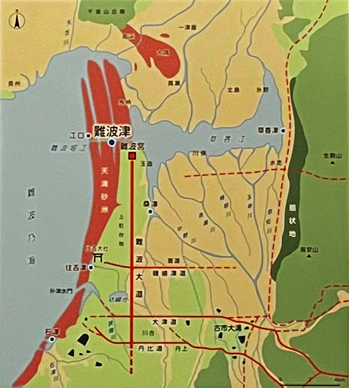
上の図は国立歴史民俗博物館展示で示された「古代の難波」地域図。
日下雅義氏の1991年中央公論社刊「古代景観の復元」からの図。
〜上町台地の北に(いまの大阪城の位置に比定)堀江が開かれ「難波津」が
できるとこの地はきわめて重要な港湾となり、台地上には難波宮も造営された。
しかし、上流に位置する奈良平野、大和・山城での相次ぐ都城建設や
大寺院建設は山林を伐採し(土木工事で)土砂も流出させた。
その結果、港湾機能に支障をきたし衰え、難波の重要性も低下した。〜
1世紀中葉と言われる「神武東征」でも図上の生駒山地の西側麓の港に
東征軍は着岸したが、迎え撃つ地元勢力・長髄彦軍は生駒山を背にした高台から
太陽を背にして散々に東征軍を撃破したとされる。東征軍側は
「われらは太陽を奉る軍なのに、太陽に向かって攻めたことが敗戦原因」として
長躯迂回作戦に転じたとされている。
いずれにせよ、現在地形とはまったく違った与条件だったことがわかる。
ほんの2000年前後ほどの過去のことだけれど、
こういった地形変化はさまざまに歴史の事情に影響したに違いない。
なんといっても歴史は極限点では軍事によって決定されるので、
その時点での地形条件に即して戦争の勝敗は決定づけられたことだろう。
その後の時代の古墳造営の地理的な移動でもこうした条件が
大いに決定要因としてあったに違いない。
いやそもそも難波宮の造営自体にこのことは明瞭に示されるし、
はるかな後代での秀吉の大阪築城の動機としてもあっただろう。
また、纏向・飛鳥・藤原京・平城京という都城建設それ自体も
下流域・大阪平野にこのような地形変動をもたらしたという事実は
古代史段階全体でも大いに影響を与えていた、ということを示している。
そうすると、仁徳天皇陵などの巨大土木による地形改造というものも
政治経済に影響をもたらせた、あるいは意図的に仕組んだとも考えられる。
水田農耕というものはこのような苛烈な本質を持っているかも知れない。
English version⬇
The 37,000-Year History of the Japanese Archipelago – 47
Seasonal changes and the transformation of rivers and plains. The civil engineering and natural modification of rice paddies and agriculture also derived topographical changes and provided the historical stage.
We modern people imagine history based on the topographical environment we can see today.
However, since the arrival of Ieyasu, the land of Tokyo has undergone vigorous civil engineering reforms.
Paddy field agriculture is a basic technology that artificially modifies the land.
The development of this technology has been enormously successful in the Japanese archipelago, even in the history of mankind.
In a country with four distinct seasons, and especially in a land where long rains such as the rainy season are a regular occurrence, it is important to manage rivers in such a way that they do not become a source of pollution.
This river management technology is the foundation of authority at the highest level.
Like Himiko, the Japanese people used magic to foresee the weather, manage agriculture appropriately, and mobilize people for civil engineering reform.
At the same time, it would have been the basis of “festival work” to mobilize the people and reorganize civil engineering.
In addition, natural changes in the land, especially in the Osaka Plain, were also a significant factor.
The above figure is from the National Museum of Japanese History and Folklore exhibition.
The figure above is a map of the “Ancient Namba” area shown at the National Museum of Japanese History.
The figure above is from “Restoration of Ancient Landscape” by Masayoshi Kusaka, published by Chuokoron-sha in 1991.
〜The area was an extremely important port and a port town, and the “Naniwazu” was built on the north side of the Uemachi Plateau (the current location of Osaka Castle).
This area became an extremely important port, and the Naniwanomiya Palace was built on the plateau.
However, the construction of a succession of capital cities and large temples in the Nara Plain, Yamato and Yamashiro, located upstream of the Naniwanomiya Palace, caused the construction of forests in the mountains and forested areas.
The construction of large temples in the Nara Plain, Yamato, and Yamashiro, located upstream, caused the cutting down of forests and the discharge of earth and sand (due to civil engineering work).
As a result, port functions were hindered and declined, and the importance of Namba also declined. ~.
In the “Jinmu expedition” said to have taken place in the middle of the 1st century, the expeditionary force landed at the port at the western foot of the Ikoma Mountains shown in the figure.
However, the local forces that intercepted the army, the Nagamayuhiko forces, were able to intercept it from the high ground with their backs against Mt.
Ikoma, from the high ground with the sun at their backs.
The eastern expeditionary force claimed that the reason for their defeat was that they attacked toward the sun, even though they were an army dedicated to the sun.
The eastern expeditionary force is said to have turned to a detour around Chosan, saying, “We are an army dedicated to the sun, but we attacked toward the sun.
In any case, it is clear that the conditions were completely different from the current situation.
Although it was only around 2,000 years ago
These geomorphological changes must have affected the historical situation in various ways.
After all, history is determined by the military at the extreme point.
The victory or defeat in a war would have been decided according to the topographical conditions at that time.
Such conditions must have been a major determining factor in the geographical movement of tomb construction in later periods.
The geographical movement of the construction of the tombs in the following period must have been a major determinant of the outcome of the war.
This is clearly shown in the construction of the Naniwanomiya Palace itself.
This is clearly shown in the construction of the Naniwanomiya Palace itself, and may have been the motivation for Hideyoshi’s construction of Osaka in a much later period.
The construction of the capital cities of Mimamukai, Asuka, Fujiwara-kyo, and Heijo-kyo itself was also motivated by the construction of Osaka Castle by Hideyoshi in a much later period.
The fact that the construction of the capital cities of Mimamukai, Asuka, Fujiwara-kyo, and Heijo-kyo itself caused such topographical changes in the lower reaches of the Osaka Plain
The fact that the construction of the capital cities of Mimamukai, Asuka, Fujiwara-kyo, and Heijo-kyo itself caused such topographical changes in the downstream area of the Osaka Plain would indicate that the entire ancient history stage was also greatly affected.
This suggests that the topographical changes caused by the huge civil engineering projects such as the Nintoku Imperial Mausoleum also had a great impact on the political economy.
This suggests that the topographical changes caused by the huge civil engineering projects such as the Nintoku Imperial Mausoleum had a great impact on the political economy, or were intentionally planned and arranged.
Paddy field agriculture may have such an intense nature.
共有:

Posted on 12月 19th, 2022 by 三木 奎吾
Filed under: 日本社会・文化研究, 歴史探訪


コメントを投稿
「※誹謗中傷や、悪意のある書き込み、営利目的などのコメントを防ぐために、投稿された全てのコメントは一時的に保留されますのでご了承ください。」
You must be logged in to post a comment.