
関西圏に数日滞在するときに行動拠点はどこがいいかと考える。
数回、関西を訪れた結果としてだんだん「大阪府堺市」に収斂している。
関西圏は、東京と関東広域との関係のように一極集中はない。
大阪は一応中心的とは言えるけれど、京都は独特の中心性があり、
一方で神戸は東京に対する横浜以上に独立性が高い。
もちろん古都・奈良はその文化性で特異な中核姓を持ち、
和歌山は和歌山で、独立性・地域性の強さを持っている。
そういうなかで堺は、京都への距離感は少し感じられるけれど、
それ以外の地域には非常に交通しやすい立地環境。
ただ、淀川河川交通の時代には京都へも容易なアクセスだったでしょうね。
現代では高速道路網へのアクセスが重要だけれど、
阪神方面とも大阪・関空方向へのアクセスも、また阪奈道へのアクセスもいい。
大阪中心・なんばへは南海鉄道で特急では20分程度。
現代での立地価値感としてはそんな考えで堺の町を選択している。
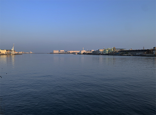
写真は海の玄関口の「旧堺灯台」付近から瀬戸内海を見たところと、
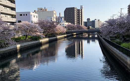
それと連関する運河地域のサクラ満開の様子、
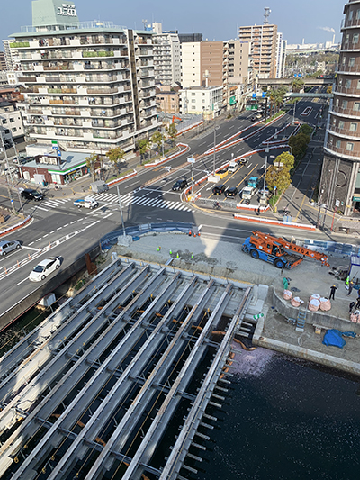
さらに現代陸路交通の枢要地である住吉橋。現在大規模改修工事中。
一方で歴史の浅い北海道在住者としては、
堺とその名前を聞いただけで沸き立つような興味関心がある。
大阪が秀吉の都市計画によって経済中心になっていった以前、
中世までの日本社会の商業中心はここだったのだと思う。
日本列島の地政学で考えると、なにより大陸との交易の中心は
瀬戸内海経済圏地域だったことはあきらか。
博多が海外との窓口になり、そこから玄界灘を経由して瀬戸内海に入る。
内海として比較的に航路安全性が高かった。
そして淡路島によって区切られたさらに内海としての大阪湾の玄関口として
堺はまことに優れた立地環境にあったのでしょう。
堺衆という商業者による自治を確立させて
中世までの自由貿易の環境を守り抜いてきたのでしょう。
商業ビジネスの交渉文化の要素が強いと思える茶の湯が
この地で盛り上がっていった経緯には、こういった背景を感じる。
さらにこの地には仁徳天皇陵があって、古代から対大陸の玄関口だったことが
史跡としてもあきらかな証言なのだろうと思う。
堺の港からこの仁徳天皇陵方角のさらに先に飛鳥方面を望める。
その間には生駒山系があって天然の「国防」の峠のように受け取れる。
古代からの対アジア国際環境へ、日本の地政学的立地選択を感じさせられる。
交易は活発にするけれど、国防の意識は高く持っている、みたいな。
わたし的にはこういう立地環境の中で育ってきた
日本人のビジネスマインド揺籃地という側面に強く惹かれています。
English version⬇
[Interest in geopolitics and location in Sakai, Osaka]
The center of Japanese commerce from the ancient times of Emperor Nintoku to the construction of Hideyoshi’s Osaka block. It is clear that it was a key point for sea, river, and land routes.・ ・ ・
When I stay in the Kansai area for a few days, I wonder where to take action.
As a result of visiting Kansai several times, it gradually converges on “Sakai City, Osaka Prefecture”.
The Kansai region is not as concentrated as the relationship between Tokyo and the Kanto region.
Although Osaka can be said to be central, Kyoto has a unique centrality.
On the other hand, Kobe is more independent of Tokyo than Yokohama.
Of course, the ancient city of Nara has a unique core surname due to its cultural characteristics.
Wakayama is Wakayama and has a strong independence and regionality.
Under such circumstances, Sakai feels a little distance to Kyoto, but
The location environment is very easy to access in other areas.
However, in the era of Yodogawa river traffic, it would have been easy access to Kyoto.
Access to the highway network is important in modern times,
Both the Hanshin area and Osaka / Kansai area have good access, and the Hanna road is also easy to access.
It takes about 20 minutes by Nankai Railway to central Osaka and Namba by limited express.
Sakai Town is selected based on this idea as a sense of location value in modern times.
The photo shows the view of the Seto Inland Sea from the vicinity of the “Old Sakai Lighthouse” at the entrance of the sea.
The state of cherry blossoms in full bloom in the canal area associated with it,
Furthermore, Sumiyoshi Bridge, which is the center of modern land transportation. Currently undergoing large-scale renovation work.
On the other hand, as a resident of Hokkaido with a short history,
I have an interest that makes me excited just by hearing Sakai and its name.
Before Osaka became an economic center due to Hideyoshi’s city planning
I think this was the commercial center of Japanese society until the Middle Ages.
Considering the geopolitics of the Japanese archipelago, above all, the center of trade with the continent is
It is clear that it was in the Seto Inland Sea economic zone.
Hakata becomes the contact point with overseas, and from there it enters the Seto Inland Sea via the Genkai Sea.
The route safety was relatively high as an inland sea.
And as the gateway to Osaka Bay as an inland sea separated by Awaji Island
Sakai must have been in an excellent location environment.
Establishing autonomy by a commercial person named Sakaishu
It must have protected the environment of free trade until the Middle Ages.
The tea ceremony, which seems to have a strong element of the negotiation culture of commercial business
I feel this kind of background in the background of the excitement in this area.
Furthermore, there is the Emperor Nintoku Mausoleum in this area, which has been the gateway to the continent since ancient times.
I think it is a clear testimony as a historic site.
From the port of Sakai, you can see the direction of Asuka further ahead of this direction of Emperor Nintoku.
In the meantime, there is the Ikomasanchi system, which can be perceived as a natural “national defense” pass.
The international environment for Asia from ancient times makes us feel Japan’s geopolitical location selection.
It seems that trade is active, but national defense awareness is high.
I grew up in this kind of location environment
I am strongly attracted to the aspect of the Japanese business mindset.
共有:

Posted on 4月 15th, 2022 by 三木 奎吾
Filed under: 住宅マーケティング, 日本社会・文化研究


コメントを投稿
「※誹謗中傷や、悪意のある書き込み、営利目的などのコメントを防ぐために、投稿された全てのコメントは一時的に保留されますのでご了承ください。」
You must be logged in to post a comment.