
本日も「四百年間のいのちの履歴書」シリーズ・家系の「故地・入野」深掘り篇。
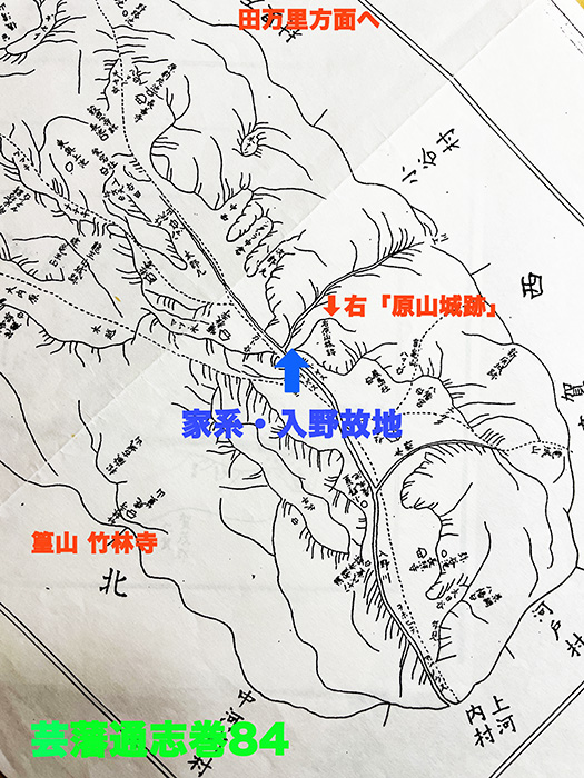
上の「絵図」は安芸広島藩・浅野氏が編纂した地誌から当該「芸藩通志・入野部分」第84巻。1663年に広島藩作成の地誌『芸備国郡志』を改訂し増補するために、1818年に再調査を開始。最終的に1825年に完成・全159巻。江戸時代以前の安芸国と備後半国(浅野氏の領国)の地理や文化、歴史を知る一級資料。主著者の頼杏坪は頼山陽の叔父。
当時のわたしの家系の姓は「原氏」で、きのう触れたような推定経緯でこの地域と、隣接する田万里地域の現地での「管理者」として浅野藩から指名されて根付いたと考えられるのです。
で、この1825年段階はわたしの家系一統はこの地を50kmほど離れた尾道近郊・今津にいたけれど、当主はこの故地を尋ねて記録を探り情報収集した上で1815年に「原氏由来の事」文書を書いた。ほぼ同時代の「公的記録」。
いろいろ興味深い「地名」痕跡がある。
入野川という地域の河川名は当然だけれど「シタハラ」中倉とか、図外の上方には「原前片池」という地名も見える。しかし一番驚かされるのが赤字で示した「右 原山城跡」という記載。調べてみると「原山城跡」としてGoogle検索では以下のような情報があった。
〜原山城跡(はらやまじょうあと)は、現在東広島市河内町入野に位置し、戦国時代に山名氏<武家氏族。山陰地方中心に勢力を持った守護・戦国大名。清和源氏義重流(「河内」源氏・新田氏流)>が築いた山城。毛利氏支配下で支城・前線基地として使われ、現在は遺構が残る史跡。標高約200mの山頂に本丸があり曲輪や石垣、土塁などの遺構が見られ城下町や水運の要衝を見下ろす戦略的な場所だったと考えられています。〜
・・・とくに最後のくだりで頓悟させられた。「水運の要衝を見下ろす戦略的な場所」。
「やっぱりこれか」であります。

戦国期の芸備地域の勢力争いの中で、この入野地域はまさにさかんに城郭が作られる要衝地域だった。物流・人流を抑えることがそのまま、武権の高度化に繋がっていた。そして江戸幕府体制の定着の中で、新規に広島地域を支配した浅野氏としてこの地域をどう制圧するべきか、そういう結果がわが家系の「入植」だったのだろう。
そのときに同じ「原」という姓が一定の納得感も伴うのではという期待もあったように感じる。ふむふむ。
●お知らせ
拙書「作家と住空間」幻冬舎から電子書籍で発刊
お求めはAmazonで。
https://amzn.asia/d/eUiv9yO

English version⬇
【Map of the Former Territory “Iri-no” from Volume 84 of the 1825 Compilation “Geihan Tsūshi”】
Having the familiar “Hara” clan serve as regional administrators might foster local ties and a sense of acceptance. Personnel deployment and governance strategy for the newly transferred Asano clan. …
Today’s installment of the “Four Hundred Years of Life’s Resume” series: Deep Dive into the Ancestral Home of the Family Lineage, “Iri no.”
Posted on 1月 14th, 2026 by 三木 奎吾
The “map” above is from Volume 84 of the “Geiban Tsūshi: Iri no Section,” a geographical survey compiled by the Asano clan of the Aki Hiroshima domain. To revise and expand the 1663 Hiroshima Domain gazetteer Geibi no Kuni Gunshi, a new survey began in 1818. It was finally completed in 1825, comprising 159 volumes. A primary source for understanding the geography, culture, and history of Aki Province and the southern part of Bitchu Province (the Asano clan’s domain) prior to the Edo period. The principal author, Yori Kyōhei, was the uncle of Yori Sanyō.
At that time, my family’s surname was “Hara.” Based on the presumed circumstances mentioned yesterday, it is thought that my family was designated by the Asano domain as the local “administrators” for this region and the adjacent Tamari area, and thus took root here.
At this 1825 stage, my entire family lineage resided in Imazu near Onomichi, about 50km away. However, the head of the family visited this ancestral land, researched records, gathered information, and wrote the document “On the Origins of the Hara Clan” in 1815. This is a nearly contemporary “official record.”
There are various intriguing traces of “place names.”
The river name “Irinogawa” is obvious, but there’s also “Shitahara” (Nakakura), and above the map outline, the place name ‘Haramekataike’ is visible. However, the most surprising thing is the notation marked in red: “Right: Harayama Castle Ruins.” Upon investigation, a Google search for “Harayama Castle Ruins” yielded the following information:
~ Harayama Castle Ruins (Hara Yama Jō Ato) is located in Iri no, Kawachi-chō, Higashi-Hiroshima City today. It was a mountain castle built by the Yamana clan
共有:
Filed under: 未分類


コメントを投稿
「※誹謗中傷や、悪意のある書き込み、営利目的などのコメントを防ぐために、投稿された全てのコメントは一時的に保留されますのでご了承ください。」
You must be logged in to post a comment.