
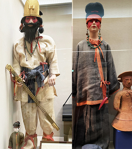
千葉県芝山町の「芝山古墳・はにわ博物館」の展示によって得られた知見に即して、可能な限り時代のリアリティを考えたいとブログシリーズで取り組んでみた。その形象「はにわ」が東北大学・田中英道先生の想像力を激しく刺激して、ユダヤ人説の根拠とされていたけれど、現地の博物館側としてはそういった表現については慎重に深入りを回避していた。
今現在で確定している考古的知見に基づき物証的な積み重ねからさまざまに展示構成されている。
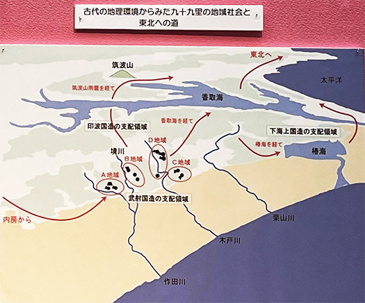
わたしとしては、この房総中部、太平洋岸から北方に展開する「香取海」そして鹿島神宮の総合的な地理感覚に強い興味を抱かせられる。古代に於いてはこの地域を経て、「武神」として古事記などにも名の出る東国三社の香取・鹿島が、東北への「出撃拠点」という位置にあることに強い興味を持たされるのです。
日本史の大ぐくりの理解として、各地域ごとの分権的並立的な権力状況から、隋唐という中国大陸で成立した強権国家への外交的対応が、日本国家の権力統合に深く影響を及ぼし、畿内・西国中心であったヤマト王権が、徐々に東国地域との統合を目指していったのがこの時代相だった。
それまでのいわば分権的な国家社会のありようから徐々に中央政権の支配力が強化されていくプロセスが、この地域での「前方後円墳」造営という明示的変化をも生み出していったのでしょう。
日本史はその後さらに隋唐との外交関係強化の証として、国内での「征夷」課題が追求されていく流れになっていく。中国大陸国家というのは四周の外敵に対して強権的であることが、非常に重要な国内的説得力だったとされる。本来の日本列島政治史としては「和を以て貴しとなす」であってそういう争乱は本流ではない流れがあったと思う。東北にとっては理不尽この上ない展開。
そういう流れの結果、この房総〜香取海周辺が対蝦夷の「出撃拠点化」していくことになったのでしょう。
関東では本来、群馬県から栃木県地域の「毛野」氏勢力の支配地域の方がより重要な地域だったとされるけれど、一時期、それら地域は火山噴火による甚大な被害を被って、勢力の衰退に陥っていたとされている。そういうことでこちらの房総側の方がより重要地域になっていった。
後の世で武士の創始ともいえる源義家が東北に進出していったのが、この地域の先のいわき市周辺の「勿来の関」を進出口としたのには、この地域で武装を整え軍勢を整えたということを表している。そのさらに後年に頼朝が旗揚げ後、いったんは房総に逃れて勢力を再結集させることに成功したのには、このような地域としての来歴、必然性があったのだと思える。
そういった意味ではこの地域の未解明の古代史は、かなり重要な意味を持っている、そんな風に考えて今後とも探訪、掘り起こしできたらいいなと考えています。
English version⬇
Geography around “Katori-kai” in the late 6th century: Chiba Shibayama Kofun Tomb Exploration-5
The ground for the Kashima and Katori warriors was chosen as the base for the “conquest of the barbarians” in the Tohoku region, and Minamoto no Yoshiie attacked beyond the Nakoso no Seki barrier. This is an exploration of the history of the area where they were based. …
In this blog series, I have tried to consider the reality of the period as much as possible in line with the findings from the exhibition at the “Shibayama Kofun Tomb and Haniwa Museum” in Shibayama Town, Chiba Prefecture. The figurative “haniwa” (a straw figure) has been a source of inspiration for Professor Hidemichi Tanaka of Tohoku University, and has been used as the basis for his Jewish theory, but the local museum has carefully avoided going into depth about such expressions.
The exhibition is composed of various exhibits based on the physical evidence accumulated from archaeological findings that have been confirmed as of now.
I am strongly interested in the overall geography of the Katori-Kai and Kashima Shrine, which stretches from the central part of Boso and the Pacific coast to the north. In ancient times, Katori and Kashima, the three shrines in the eastern part of Japan, were named in the Kojiki, the oldest extant chronicle of Japan, as “warrior gods” through this region, and I am strongly interested in their position as a “base of departure” to the northeast.
As a broad understanding of Japanese history, the diplomatic response to the Sui and Tang dynasties, which were powerful states established on the Chinese continent, had a profound effect on the consolidation of power in Japan, and the Yamato kingdom, which had been centered in the Kinai and western part of Japan, gradually sought to integrate with the eastern regions.
The process of the gradual strengthening of the central government’s dominance over the previously decentralized state and society must also have led to the explicit change in the construction of “anterior posterior circular mounds” in this region.
Japanese history then further developed into a trend of pursuing domestic “barbarian conquest” agendas as a sign of strengthening diplomatic relations with the Sui and Tang dynasties. It is said that the Chinese continental state was a very important domestic persuasion to be powerful against the external enemies of the four circuits. In the original political history of the Japanese archipelago, “harmony is the key to success,” and such conflicts were not the main stream. For the Tohoku region, this was an unreasonable development.
As a result of this trend, the area between Boso and Katori-kai became a “base of operations” against the Emishi.
The area controlled by the “Meno” clan in the Kanto region from Gunma to Tochigi prefectures is said to have been more important, but for a time these areas suffered severe damage from volcanic eruptions and their power declined. For this reason, the Boso side became a more important area.
In later times, Minamoto no Yoshiie, the founder of the samurai class, advanced into the Tohoku region and chose “Nakosuno-no-seki” in the vicinity of Iwaki City as his entry point, indicating that he had armed himself and built up his army in this area. It seems that Yoritomo’s success in regrouping his forces in this area was due to the history and inevitability of this region.
In this sense, the unexplored ancient history of this region is of considerable importance, and I hope to continue to explore and excavate it.
共有:

Posted on 12月 3rd, 2023 by 三木 奎吾
Filed under: 日本社会・文化研究, 歴史探訪


コメントを投稿
「※誹謗中傷や、悪意のある書き込み、営利目的などのコメントを防ぐために、投稿された全てのコメントは一時的に保留されますのでご了承ください。」
You must be logged in to post a comment.