
「法隆寺宝物館「聖徳太子絵伝」についての記事、第8回目の今回は、この時代ようやく開発が進み始めていたとされる吾妻・板東地域とさらに東北の対蝦夷認識についてです。
このシリーズの第一回はこちら→端正なモダニズム「法隆寺宝物館」探訪。
古代国家ヤマト政権というのは、どういった「国土」地理認識を持っていたのかというのは後世のわれわれにはわかりにくい。聖徳太子執政の時代、600年代の初頭時期には対大陸国家、対朝鮮半島国家への外交・国体認識に比較して、日本列島地域への関心程度は十分に伝わってこない。
そういった興味で聖徳太子絵伝のエピソード群を子細に見ているけれど、いわゆる関東地域を指す東国や、その「奥地」である東北・蝦夷への関与テーマはそれほど存在しない。
東国については現在の群馬県・栃木県地域である「毛野」地域は王朝国家としても認識はあったはずだと思う。この時代を少し下る663年の白村江海戦では上毛野稚子という「将軍」が総勢2万7千軍勢を率いて海外戦争を戦っている。当然ながら、ヤマト政権の有力な地方勢力として活躍しているワケだ。
この上毛野氏は実在が確実であるとされる10代天皇の崇神帝の血筋が関東に下って勢力を築いたとされる。この聖徳太子の世の天皇は33代推古天皇であるので、天皇在位年から考えても200-300年はヤマト王権による関東経営の実質はあったことが推察できる。それも海外派遣軍の一司令官になるほどには軍勢をまとめていたことを考えれば、相当有力な王権内勢力ではあっただろう。
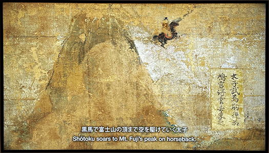
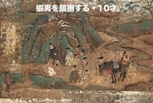
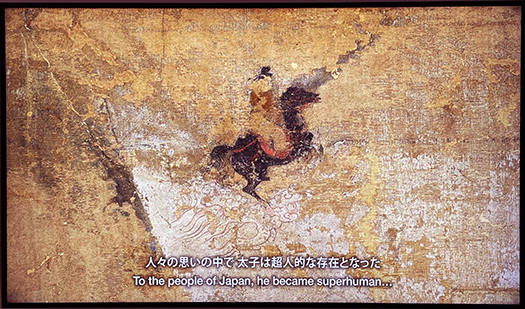
聖徳太子絵伝ではかろうじて「富士登山」とか、甲斐国から黒駒が贈られてきたとか、蝦夷の記述とかが出てくる程度。蝦夷の記述に至っては上半身裸の姿で描かれていて、いかにも野蛮で化外なるものとして描かれている。
やはり仏教導入とか遣隋使の派遣などの大陸・半島などの海外との交渉が日本という国体を整備する基本的な志向性だったことが伝わってくる。富士についても、事実として太子が現地に赴いたというよりも、絵伝が成立した1069年段階の国土範囲認識のために後世に挿話されたように思える。
やはりヤマト王権としては、大陸・半島との外交が喫緊な対応課題であって、国土領域の東進拡大というテーマは、むしろ前時代のヤマトタケル派遣時代よりも後退していたのかも知れない。やはり王権維持のためには朝鮮半島からの輸入に頼っていた鉄製品が最重要な戦略物資であって、国内で安定的な鉄生産が開始される奈良期まで東国やその北方の蝦夷社会への関心は薄かったということだろうか。
初期のヤマト王権のこうした認識を改めて探究していて、アヅマという地域表現は、サツマという表現と対応的だったという説と遭遇した。大和平野と関西地域、環瀬戸内海、九州北部地域がこの時代の基本的な国土範囲認識であり、その領域外へのこうした呼称にその残滓が残っているという説。
はじめてじっくり考えて見る聖徳太子絵伝、いろいろな日本社会像を教えられる。
English version⬇
Recognition of the East and Emishi in the Asuka Period (The Gallery of Horyuji Treasures-8)
In the picture biography of Prince Shotoku, Mt. Fuji is the “Far East” in terms of land area recognition, and the Emishi were recognized as a truly foreign nation. The emphasis continued to be on the dense foreign relations with the continental peninsula.
In this eighth installment of our series of articles on the “Shotoku Taishi Eiden” in the Gallery of Horyuji Treasures, we focus on the Agatsuma and Bando areas, which are believed to have finally begun to develop during this period, as well as the perception of Emishi in the northeastern part of Japan.
It is difficult for us to understand how the ancient Yamato regime perceived “national land” and geography. During the time of Prince Shotoku’s regency in the early 600s, the degree of interest in the Japanese archipelago was not fully understood in comparison to the diplomatic and national awareness of the continental and Korean peninsula states.
With this interest, I have been looking closely at the episodes in the Shotoku Taishi Eaden, but there are not so many themes involving the Eastern Province, which refers to the so-called Kanto region, or the Tohoku and Emishi, which are the “back regions” of the Kanto region.
As for the eastern provinces, I believe that the “Kono” region, which is the area of present-day Gunma and Tochigi prefectures, must have been recognized as a dynastic state as well. A little later, in 663, at the Battle of Hakuchon River, a “shogun” named Kamomono Wakiko led a total of 27,000 troops to fight an overseas war. Naturally, he was a powerful local force in the Yamato regime.
The Kamomono clan is said to have been descended from the lineage of the 10th emperor, the Emperor Sojin, who is believed to have existed and built up his power in the Kanto region. Since the emperor of Prince Shotoku’s reign was the 33rd Emperor Suiko, it can be inferred that the Yamato royal authority had a substantial presence in the Kanto region for 200 to 300 years, considering the years of the emperor’s reign. Considering the fact that he was able to organize his forces to the extent of becoming a commander of an army dispatched overseas, he must have been a very powerful force within the royal authority.
In the pictorial biography of Prince Shotoku, there are only a few references to “climbing Mount Fuji,” a gift of Kurokoma from Kai Province, and a description of Emishi. In the description of Emishi, they are depicted with their upper body naked, and are depicted as barbaric and ungodly.
This shows that the introduction of Buddhism and the dispatch of envoys to Sui Dynasty China and Sui Dynasty Japan were fundamental to the development of Japan as a nation. Fuji, too, seems to have been a story that was inserted in later times in order to recognize the extent of the land in 1069, when the pictorial record was compiled, rather than the fact that Taishi actually visited the site.
The Yamato royal authority had the urgent task of diplomacy with the continent and peninsula, and the theme of eastward expansion of the land area may have been more of a regression from the previous era of Yamatotakeru’s dispatch. Iron products, which were imported from the Korean peninsula, were the most important strategic commodity for the maintenance of royal power, and the Yamato Takeru had little interest in the eastern provinces or the Emishi society to the north until the Nara period, when stable domestic iron production was initiated.
In my renewed exploration of these perceptions of the early Yamato kingdom, I came across a theory that the regional expression Azuma corresponded to the expression Satsuuma, which was used to describe the Yamato Plain, the Kansai region, and the Rim of Japan. The Yamato Plain, the Kansai region, the Seto Inland Sea, and northern Kyushu were the basic land areas recognized during this period, and this theory suggests that the names for areas outside of the Yamato Plain still retain traces of the Yamato Plain.
The pictorial biography of Prince Shotoku, which is being looked at carefully for the first time, gives us a variety of images of Japanese society.
共有:

Posted on 6月 5th, 2023 by 三木 奎吾
Filed under: 歴史探訪


コメントを投稿
「※誹謗中傷や、悪意のある書き込み、営利目的などのコメントを防ぐために、投稿された全てのコメントは一時的に保留されますのでご了承ください。」
You must be logged in to post a comment.