本文へジャンプ

【古代史と地震噴火・天変地異 日本列島37,000年史-48】


わたしたち現代人も多くの天変地異によって社会変動を経験した。
阪神淡路大震災、東日本大震災などによって社会は深甚な打撃を受けた。
現実の被害を超えて人のこころ、社会そのものにも影響をもたらせた。
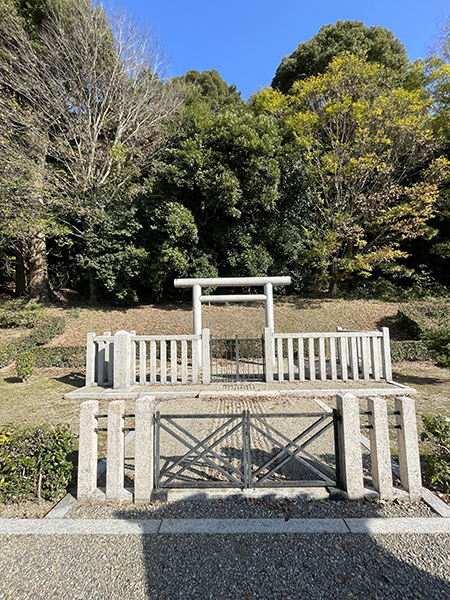
国立歴史民俗博物館展示パネルでも古代での災害記録が記されている。
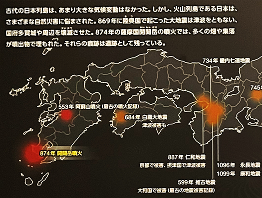
〜古代の日本列島はあまり大きな気候変動はなかった。しかし火山列島である
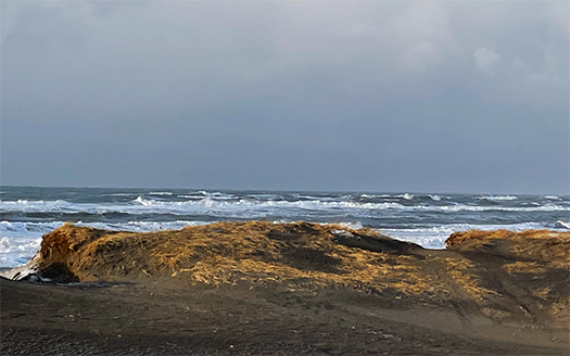
日本はさまざまな自然災害に悩まされた。869年に陸奧国で起こった大地震は
大規模な津波を伴い国府多賀城や周辺を潰滅させた。
874年の薩摩開聞岳噴火では多くの畑や集落が噴出物で埋もれた。〜
以下にパネルに表記された主な古代の自然災害。
・553年 阿蘇山噴火(記録での最古の噴火)
・599年 推古地震(大和国被害〜最古の地震被害記録)
・684年 白鳳大地震(伊予南部・津波被害も)
・6世紀初頭 榛名山二ツ岳噴火(古代豪族・上毛野氏本拠を直撃)
・6世紀中頃 榛名山二ツ岳噴火
・734年 畿内七道地震
・745年 天平地震(美濃国で被害)
・800~802年 富士山延暦大噴火
・818年 弘仁地震(関東諸国で被害、洪水も)
・864〜66年 富士山貞観大噴火
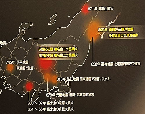
・869年 陸奧三陸沖・貞観地震と大津波(多賀城津波被害)
・871年 鳥海山噴火
・878年 元慶地震(相模・武蔵国で被害)
・887年 仁和地震(京都で被害、摂津で津波被害)
・・・国家機構として整備がされて以降の歴史年代でこうした記録。
それ以前の段階でも天変地異はもちろん多数発生していたことだろう。
そうした地震などが、祭政を司るヤマト王権にとってどのように影響したか、
現実に残された歴史経緯から想像力を巡らせるべきなのかもしれない。

6世紀初頭と中頃と記された榛名山噴火ではそれまでの古代勢力、
上毛野氏の本拠地域が壊滅的な打撃を受けたという。
古代中央軍事勢力・ヤマトタケル説話で名の残る地名
吾妻(あずま)としてはこの有力地域が眺望されたはず。
そういう吾妻中心地が潰滅したことで関東の歴史が大きく変動したと思える。
上毛野氏は古代の対外戦争でも中心的な軍事勢力として名が残るが
その後、政戦の記録からその名前が消滅し上野・下野の地名に
名前を留めるに過ぎなくなる。この榛名山二ツ岳噴火との強い関連が想像できる。
また古代の東日本大震災・貞観地震では王権の地方統治機構・多賀城が潰滅。
多賀城には関東を中心にした暴力装置・武装勢力が常駐しただろう。
その勢力の人命の多くが失われた可能性は高いと思われる。
中央政権のパワーが大きく削がれたことは疑いがない。
政治変動の基底要因としてもこうした天変地異が影響したと考えられる。
歴史年代として記録の残る時代でもこうした想像が可能だが
それ以前の社会でも自然災害はさらに大きな要因として働いたに違いない。

English version⬇

Ancient History and Earthquakes, Eruptions, and Natural Disasters: The 37,000-Year History of the Japanese Islands – 48
Numerous disasters have been recorded even after the age of historical records. Even before that, they occurred constantly and frequently. They must have had a strong influence on the mind and history. ・・・・.

We modern people have also experienced social changes due to many natural catastrophes.
The Great Hanshin-Awaji Earthquake, the Great East Japan Earthquake, and other disasters dealt a profound blow to society.
Beyond the actual damage, these disasters also had an impact on the human mind and society itself.
The National Museum of Japanese History exhibition panel also records disasters in ancient times.
〜The Japanese archipelago in ancient times did not experience major climatic changes. However, as a volcanic archipelago
In 869, a major earthquake occurred in Rikugunkoku, which was accompanied by a massive tsunami.
In 869, a major earthquake in Riku-Onkoku was accompanied by a massive tsunami that destroyed Tagajo, the national capital, and the surrounding area.
The eruption of Mt. Kaimondake in Satsuma in 874 buried many fields and villages in the eruption. ~.
The following are the major ancient natural disasters described in the panel.
Eruption of Mt. Aso in 553 (the earliest recorded eruption)
599 Suiko Earthquake (damage in Yamato Province – oldest record of earthquake damage)
684: Great Hakuho Earthquake (also caused tsunami damage in southern Iyo)
Early 6th century: Mt. Haruna Futatsudake eruption (hit the home of the ancient Kamimono clan)
Eruption of Mt. Haruna Futatsudake in the mid-6th century.
734 Kinai-Shichido Earthquake
745 Tenpyo Earthquake (damage in Mino Province)
800~802: Enryaku volcanic eruption of Mt.
818 Konin Earthquake (damage and flooding in Kanto region)
864-66: Great eruption of Mt.
869: Jogan earthquake and tsunami off the coast of Riku-On-Sanriku (damage from Tagajo tsunami)
871: Eruption of Mt.
878: Genkei Earthquake (damage in Sagami and Musashi Provinces)
887 Niwa Earthquake (Damage in Kyoto, Tsunami damage in Settsu)
These records are from the period after the establishment of the national organization.
Of course, there must have been many natural disasters even before that.
How such earthquakes affected the Yamato kingdom, which was in charge of ritual administration, is not clear.
Perhaps we should use our imagination to determine how such earthquakes and other events would have affected the Yamato royal government, which controlled the rituals.

The eruption of Mt. Haruna in the early and middle of the 6th century destroyed the ancient power that had been in power until then, the Kamimono clan.
The eruption of Mt. Haruna in the early to mid-6th century is said to have devastated the home region of the Kamomono clan, the ancient power that had been in power until that time.
Place names that remain in the legend of Yamatotakeru, the ancient central military force
This area must have been viewed as Azuma.
The destruction of the Azuma center is thought to have caused major changes in the history of the Kanto region.
The Kamimono clan’s name remained as a major military force in the ancient wars against Japan, but the records of political battles show that the Kamimono clan’s name did not change.
Later, their name disappeared from the records of political wars, and they were only mentioned in the names of places in Ueno and Shimono.
The name of the Jomono clan has remained only in the names of places in the Ueno and Shimono regions. It can be imagined that there is a strong connection with the eruption of Futatsudake on Mt.
In addition, the ancient Great East Japan Earthquake of Jogan destroyed Tagajo, the local seat of royal rule.
The Taga Castle would have been the permanent seat of a violent apparatus and armed forces centered in the Kanto region.
It is highly likely that many of the lives of those forces were lost.
There is no doubt that the power of the central regime was greatly reduced.
Such natural cataclysms are also thought to have been a fundamental factor in political change.
It is possible to imagine such an event even in the recorded historical period, but even in earlier societies
Natural disasters must have been an even more significant factor in earlier societies.

【急報/新潟など湿雪での停電〜ReplanWEB参考記事】


ブログ連載記事を書いている間に、東北電力管内・新潟、山形など
日本海側地域で大雪との情報。で、この時期の大雪では
電線架線に湿った雪が降り積もり、停電のリスクが顕著に増大する。
・・・という情報について読者の住宅研究者のT氏から至急のメール。
「アー来ちゃったという湿った雪の猛吹雪。
残念ながら、報道は車の渋滞の記事ばかりでして...。
2022/12/19 19:05分現在 東北電力管内で18200戸で停電。
東北電力も鋭意復旧中と思いますが、吹雪のなかの作業ですから
すぐに復旧にはなりにくい。・・・」というお知らせ。
昨日は札幌市内で日中でも外気温-4度という急な冷え込みでわたしも外出時、
非常に寒気〜さむけ〜を感じて帰宅後、その体感した寒気が風邪に至らないように
養生に専心しておりました。冬の最盛時よりも油断のあるこの時期の方が
より注意すべき時期であるとも思います。
冬場「停電」というのは寒冷地では即刻で室温低下をもたらし、
ライフラインに直結する機能を停止させてしまう。
とくにいまの感染症との戦いの時期には要注意となる。
不安な心理とか、健康被害の引き金にもなり得る。
ということで注意喚起のためにReplanWEBに過去掲載の記事をご紹介します。

停電時も安心で、役に立つ。最小限のオフグリッドとは?
LDKをシェルター化!冬の停電でも凍えない家づくりの工夫
停電時の味方、石油ストーブ。使うときの注意点とは?
の3本の記事になります。
これらは2018年9月の北海道全域停電の経験を踏まえたもの。
〜北海道全域の大停電からおよそ1ヵ月半後。今回のような大停電への備え方と、
それがもし冬場に起こったときの対処の仕方、ということで
旭川市にある北方建築総合研究所所長の鈴木大隆さんを訪ねました。
鈴木さんは長年に渡って北海道をはじめ日本の家づくりの研究に携わってきた、
いわば日本の住宅建築のエキスパート。新潟県の中越地震や東日本大震災などの
大きな災害時には現地で建物被害状況調査や被災者の方々の
暮らし・住まいの再建に関わるなど、災害時の住環境の実態についても造詣が深い。〜
という一連の記事であります。

いま、停電中の各地のみなさんはまさに、
給湯・暖房・照明はストップ。いつ復旧するか判らない心細い夜。
もちろん急迫する事態に対してはこういう情報は即応できるものではない。
住宅の対応として、万が一に対応できる住宅性能を用意しましょうということになる。
不眠不休に近い停電復旧努力を続けている現場のみなさんの労苦を思いつつ、
これからもあり得るこうした暮らしの中の不安について
その「凌ぎ方・心理の持ち方」なども考えていく必要があると言えますね。

English version⬇

[Urgent Report / Power Outages in Niigata and Other Wet Snow Areas – ReplanWEB Reference Article
A blizzard of wet snow with a high risk of power outages. Traffic jams are one thing, but how should we think about how to spend a winter night in the midst of anxiety psychology? …

While writing this blog series, I was informed of heavy snowfall in the Tohoku Electric Power Company service area, Niigata, Yamagata, and other areas on the Sea of Japan coast.
and Niigata, Yamagata, and other areas on the Sea of Japan side of the country. And with heavy snowfall at this time of year, the risk of power outages increases markedly.
The risk of power outages increases significantly due to the accumulation of wet snow on overhead power lines.
Mr. T, a housing researcher, sent us an urgent e-mail about this information.
It’s a blizzard of wet snow,” he said.
Unfortunately, the news reports are all about traffic jams…” (2022/12/19 19:00)
As of 19:05 on 12/19/2022, 18,200 households in Tohoku Electric Power Company’s service area are without power.
Tohoku Electric is working hard to restore power, but since they are working in the middle of a blizzard
The power is unlikely to be restored anytime soon. The power is not restored immediately.
Yesterday, it was suddenly cold in Sapporo, with outside temperatures as low as -4 degrees Celsius even during the daytime, and I felt very cold when I went out.
When I went out, I felt a chill or a chill, and after returning home, I was trying to cure myself so that the chill I felt would not lead to a cold.
I was trying to take good care of myself so that the cold I felt would not turn into a cold. I think we should be more careful this time of year when we are more careless than in the height of winter.
I think this is the time to be more careful.
In winter, a “power outage” can cause an immediate drop in room temperature in cold regions
This is especially true in the current battle against infectious diseases.
This is especially important during this time of year when we are battling infectious diseases.
It could trigger anxiety and health hazards.
So as a reminder, here are some articles that have appeared on ReplanWEB in the past.

Safe and useful during power outages. What is the minimum off-grid?
Shelter the LDK! How to build a house that won’t freeze even during a winter power outage
Oil heaters are your friend during power outages. What are the precautions to take when using it?
The three articles will be based on the following three articles.
These are based on the experience of the September 2018 Hokkaido-wide power outage.
~About a month and a half after the Hokkaido-wide blackout. How to prepare for a major power outage like this one, and
how to deal with it if it happens in the wintertime.
We visited Mr. Daitaka Suzuki, director of the Northern Architectural Research Institute in Asahikawa City.
Mr. Suzuki is an expert on Japanese house building, having spent many years researching house building in Hokkaido and other parts of Japan.
He is, so to speak, an expert on Japanese residential architecture. He has also been involved in the Niigata Chuetsu Earthquake, the Great East Japan Earthquake, and other major disasters.
During major disasters such as the Chuetsu Earthquake in Niigata Prefecture and the Great East Japan Earthquake, he was on site to survey the damage to buildings and to help the victims rebuild their lives and homes.
He is also well versed in the realities of the living environment in times of disaster, having been involved in building damage assessments and rebuilding the lives and homes of disaster victims. ~.
I am very familiar with the reality of the living environment at the time of a disaster.

The people in the areas where the power is out right now are in a state of emergency.
Hot water, heating, and lighting have stopped. It is a night of uncertainty as to when the power will be restored.
Of course, this kind of information is not an immediate response to an urgent situation.
The response of the house is to prepare the performance of the house to cope with any eventuality.
While thinking of the labor and hardship of the people on site who have been working tirelessly to restore the power outage, I also think of the anxiety and anxiety of the people living in such a situation, which may continue in the future.
I would like to talk about the anxiety in our daily lives that is likely to continue in the future.
We also need to think about how we can cope with such uncertainties in our daily lives.

【歴史を変える与条件・列島地形変化 日本列島37,000年史-47】


わたしたち現代人はいま見えている地形環境で歴史も想像する。
しかし、東京の地は家康の入部以来、旺盛な土木改編が加えられてきている。
水田農耕とは土地を人為的に改造することが基礎技術。
そしてその技術発展は人類史の中でも日本列島で巨大な成功を収めた。
四季変化が明瞭でとくに梅雨などの長雨が恒常化している国土では
こうした河川管理技術というのは権力の最高レベルの権威基盤。
卑弥呼のように呪術で天候を予見し、適切な農業管理を行い、
同時に人びとを動員して土木改編を加えるのは「まつりごと」の基本だった。
その上でさらに国土の自然変化というものも、
とくに大阪平野部では顕著だったといわれる。
上の図は国立歴史民俗博物館展示で示された「古代の難波」地域図。
日下雅義氏の1991年中央公論社刊「古代景観の復元」からの図。
〜上町台地の北に(いまの大阪城の位置に比定)堀江が開かれ「難波津」が
できるとこの地はきわめて重要な港湾となり、台地上には難波宮も造営された。
しかし、上流に位置する奈良平野、大和・山城での相次ぐ都城建設や
大寺院建設は山林を伐採し(土木工事で)土砂も流出させた。
その結果、港湾機能に支障をきたし衰え、難波の重要性も低下した。〜
1世紀中葉と言われる「神武東征」でも図上の生駒山地の西側麓の港に
東征軍は着岸したが、迎え撃つ地元勢力・長髄彦軍は生駒山を背にした高台から
太陽を背にして散々に東征軍を撃破したとされる。東征軍側は
「われらは太陽を奉る軍なのに、太陽に向かって攻めたことが敗戦原因」として
長躯迂回作戦に転じたとされている。
いずれにせよ、現在地形とはまったく違った与条件だったことがわかる。

ほんの2000年前後ほどの過去のことだけれど、
こういった地形変化はさまざまに歴史の事情に影響したに違いない。
なんといっても歴史は極限点では軍事によって決定されるので、
その時点での地形条件に即して戦争の勝敗は決定づけられたことだろう。
その後の時代の古墳造営の地理的な移動でもこうした条件が
大いに決定要因としてあったに違いない。
いやそもそも難波宮の造営自体にこのことは明瞭に示されるし、
はるかな後代での秀吉の大阪築城の動機としてもあっただろう。
また、纏向・飛鳥・藤原京・平城京という都城建設それ自体も
下流域・大阪平野にこのような地形変動をもたらしたという事実は
古代史段階全体でも大いに影響を与えていた、ということを示している。
そうすると、仁徳天皇陵などの巨大土木による地形改造というものも
政治経済に影響をもたらせた、あるいは意図的に仕組んだとも考えられる。
水田農耕というものはこのような苛烈な本質を持っているかも知れない。

English version⬇

The 37,000-Year History of the Japanese Archipelago – 47
Seasonal changes and the transformation of rivers and plains. The civil engineering and natural modification of rice paddies and agriculture also derived topographical changes and provided the historical stage.

We modern people imagine history based on the topographical environment we can see today.
However, since the arrival of Ieyasu, the land of Tokyo has undergone vigorous civil engineering reforms.
Paddy field agriculture is a basic technology that artificially modifies the land.
The development of this technology has been enormously successful in the Japanese archipelago, even in the history of mankind.
In a country with four distinct seasons, and especially in a land where long rains such as the rainy season are a regular occurrence, it is important to manage rivers in such a way that they do not become a source of pollution.
This river management technology is the foundation of authority at the highest level.
Like Himiko, the Japanese people used magic to foresee the weather, manage agriculture appropriately, and mobilize people for civil engineering reform.
At the same time, it would have been the basis of “festival work” to mobilize the people and reorganize civil engineering.
In addition, natural changes in the land, especially in the Osaka Plain, were also a significant factor.
The above figure is from the National Museum of Japanese History and Folklore exhibition.
The figure above is a map of the “Ancient Namba” area shown at the National Museum of Japanese History.
The figure above is from “Restoration of Ancient Landscape” by Masayoshi Kusaka, published by Chuokoron-sha in 1991.
〜The area was an extremely important port and a port town, and the “Naniwazu” was built on the north side of the Uemachi Plateau (the current location of Osaka Castle).
This area became an extremely important port, and the Naniwanomiya Palace was built on the plateau.
However, the construction of a succession of capital cities and large temples in the Nara Plain, Yamato and Yamashiro, located upstream of the Naniwanomiya Palace, caused the construction of forests in the mountains and forested areas.
The construction of large temples in the Nara Plain, Yamato, and Yamashiro, located upstream, caused the cutting down of forests and the discharge of earth and sand (due to civil engineering work).
As a result, port functions were hindered and declined, and the importance of Namba also declined. ~.
In the “Jinmu expedition” said to have taken place in the middle of the 1st century, the expeditionary force landed at the port at the western foot of the Ikoma Mountains shown in the figure.
However, the local forces that intercepted the army, the Nagamayuhiko forces, were able to intercept it from the high ground with their backs against Mt.
Ikoma, from the high ground with the sun at their backs.
The eastern expeditionary force claimed that the reason for their defeat was that they attacked toward the sun, even though they were an army dedicated to the sun.
The eastern expeditionary force is said to have turned to a detour around Chosan, saying, “We are an army dedicated to the sun, but we attacked toward the sun.
In any case, it is clear that the conditions were completely different from the current situation.

Although it was only around 2,000 years ago
These geomorphological changes must have affected the historical situation in various ways.
After all, history is determined by the military at the extreme point.
The victory or defeat in a war would have been decided according to the topographical conditions at that time.
Such conditions must have been a major determining factor in the geographical movement of tomb construction in later periods.
The geographical movement of the construction of the tombs in the following period must have been a major determinant of the outcome of the war.
This is clearly shown in the construction of the Naniwanomiya Palace itself.
This is clearly shown in the construction of the Naniwanomiya Palace itself, and may have been the motivation for Hideyoshi’s construction of Osaka in a much later period.
The construction of the capital cities of Mimamukai, Asuka, Fujiwara-kyo, and Heijo-kyo itself was also motivated by the construction of Osaka Castle by Hideyoshi in a much later period.
The fact that the construction of the capital cities of Mimamukai, Asuka, Fujiwara-kyo, and Heijo-kyo itself caused such topographical changes in the lower reaches of the Osaka Plain
The fact that the construction of the capital cities of Mimamukai, Asuka, Fujiwara-kyo, and Heijo-kyo itself caused such topographical changes in the downstream area of the Osaka Plain would indicate that the entire ancient history stage was also greatly affected.
This suggests that the topographical changes caused by the huge civil engineering projects such as the Nintoku Imperial Mausoleum also had a great impact on the political economy.
This suggests that the topographical changes caused by the huge civil engineering projects such as the Nintoku Imperial Mausoleum had a great impact on the political economy, or were intentionally planned and arranged.
Paddy field agriculture may have such an intense nature.

【最初期前方後円墳「箸墓古墳」 日本列島37,000年史-46】


纏向遺跡は3世紀の頃のヤマト王権の姿を伝えているけれど、
この三輪山を仰ぎ見る王権の地にはほど近くに箸墓古墳が造営されている。
行ってみると宮内庁によって陵墓管理されていることがわかる。
〜箸墓古墳は奈良県桜井市箸中にある古墳。形状は前方後円墳。
実際の被葬者は不明だが宮内庁により「大市墓」として
第7代孝霊天皇皇女の倭迹迹日百襲姫命の墓に治定されている。
また笠井新也の研究以来、邪馬台国の女王卑弥呼の墓とする学説がある。
出現期古墳の中でも最古級と考えられている前方後円墳。〜

宮内庁としては天皇陵ではないけれど、王族の陵墓とは考えている。
特殊な地位を保持した王族の女性が被葬されていることが確定している。
纏向遺跡が第10代崇神天皇の王宮であるとすると、
この箸墓は「大叔母」にあたる倭迹迹日百襲姫命のために造営されたとなる。
造営年代の特定ではほぼ同時期に建立されたことになっている。
この倭迹迹日百襲姫命は、三輪山の神霊である大物主の妻となった。
〜然れども其の神、常に昼は見えずして夜のみ来す。倭迹迹姫命は夫に語りて
君常に昼は見えずして夜のみ来す。分明に其の尊顔を視ること得ず。願わくば
暫留まりたまへ。明旦に仰ぎて美麗しき威儀を勤たてまつらむと欲ふといふ。
大神対へて曰はく「言理灼然なり、吾明旦に汝が櫛笥に入りて居らむ。
願はくば吾が形にな驚きましそ」とのたまふ。ここで倭迹迹姫命は
心の内で密かに怪しんだが明くる朝を待って櫛笥を見ればまことに美麗な小蛇。
その長さ太さは衣紐ぐらいであった。それに驚いて叫んだ。
大神は恥じて人の形とになって其の妻に謂りて曰はく「汝、忍びずして吾に羞せつ。
吾還りて汝に羞せむ」とのたまふ。よって大空をかけて御諸山に登ってしまった。
ここで倭迹迹姫命仰ぎ見て悔いて座り込んだ。則ち箸に陰を憧きて薨りましぬ。
乃ち大市に葬りまつる。故、時人其の墓を号けて箸墓と謂ふ。〜

一方で崇神天皇の御代に人口の半数もの餓死者が出たとき、
神意が天皇に告げて、三輪山(御諸山)をしっかり祀るために大物主所縁の人物を
神主にせよとされ、そのようにしたところ災禍は沈静化したという。
このような説話が二重写しになっている。考古的には同時代と比定される。
事実としては天候不順によって冷害か日照りが奈良盆地を襲ったのかも知れない。
初期の王権とは水田を土木工事で造営し、灌漑作業で水源を管理して
水田農耕を一元的に支配した存在だったことは明らか。
国というものは、建国神話に託された強い意図を持って創建されていくものであって、
こうした神話・説話にはそういった志向性が表現されているのでしょう。
事実はそこに反映されその意図に添って解釈された。
スフィンクスの謎かけに近いけれど、相当の真実も見えてくると思います。

English version⬇

The First Posteroposterior Circular Tumulus “Chopstick Tomb” 37,000 Years of the Japanese Archipelago – 46
Myths and archeological facts are synchronized in the area of the tombs of Chopedombs and Muko-no-mukai. History and archaeology coexist in a quiet landscape. …

The Mimamukai ruins tell the story of the Yamato kingdom in the 3rd century, but the tomb of Chopstick Tomb was built not far from the site of the kingdom looking up at Mt.
Chopstick tomb tombs were built not far from the site of this royal authority looking up at Mt.
The tombs are managed by the Imperial Household Agency.
〜The tomb mound is located in Hashinaka, Sakurai City, Nara Prefecture. The shape of the tomb is a forward-rear circular mound.
The actual burial site is unknown, but the Imperial Household Agency has designated the tomb as “Oichi no Haka,” which means “Great City Tomb.
The actual burial site is unknown, but it has been designated by the Imperial Household Agency as the tomb of the 7th Emperor Koryo’s daughter, Wajaku-no-Hyakuso-no-Mikoto.
Since the research of Kasai Shinya, there is a theory that it may be the tomb of Himiko, the Queen of Yamataikoku.
The tomb is considered to be one of the oldest tombs of the emergence period. ~.

The Imperial Household Agency considers it to be a royal mausoleum, although it is not an emperor’s tomb.
It has been established that a royal female who held a special position is buried there.
Assuming that the Mimamukai site is the royal palace of the 10th Emperor Sublime.
This chopstick tomb was built for the “great-aunt” of the 10th Emperor Sublime.
According to the date of construction, they were built at about the same time.
This Wajaku-no-Tsukihime-no-Mikoto became the wife of Ohmononushi, the spirit of Mount Miwa.
〜However, the deity is always unseen in the daytime and comes only at night. Yamatotsu-hime-no-Mikoto spoke to her husband and said
You are always unseen by day and come only by night. You cannot see his face clearly. I pray that you may stay for a while.
I beg you to stay for a while. I desire to see you perform a beautiful ceremony on the first day of the new year.
I wish to enter your comb-over on Mingtan.
I wish to be surprised at the shape I take. At this point, Yamatotake-no-Mikoto
But when she waited for the next morning and looked into the comb chest, she saw a small serpent of great beauty.
The length and thickness of the snake was about the length and thickness of a garment cord. Startled by this, he exclaimed, “What a beautiful snake!
Ashamed, the goddess took human form and said to his wife, “Thou art ashamed of me, for thou hast not been patient with me.
I will return and shame you. So he took to the skies and climbed up to the top of Mt.
Here, he looked up at the deity and sat down, repenting. He sat down in repentance, and was buried with a shadow on his chopsticks.
He was buried in Oichi. The tomb is called “Chopstick Tomb” by the people of the time. 〜The first half of the second half of the third century BC

On the other hand, when half of the population starved to death during the reign of Emperor Sojin
The divine will told the Emperor to appoint a person related to Omotonushi as the chief deity in order to firmly worship Mount Miwa (Mt. Omorozan).
The emperor told the deity to appoint a person related to Omotoshu as the chief priest to ensure the worship of Mt.
This is a duplicate of the legend. Archaeologically, they are comparable to the same period.
In fact, it is possible that cold or drought struck the Nara Basin due to bad weather.
Early kingship was based on the idea of building rice paddies by civil engineering and managing the water supply through irrigation work.
It is clear that the early kings were the centralized rulers of rice paddies and agriculture.
A nation is founded with a strong intention, which is entrusted in the founding myths.
These myths and legends may express such an orientation.
Facts were reflected in them and interpreted according to their intentions.
It is almost like the riddle of the Sphinx, but I think it also reveals a considerable amount of truth.

【卑弥呼=日の巫女「アマテラス」論 日本列島37,000年史-45】


卑弥呼と魏志倭人伝の条にこのブログ連載として突入しております(笑)。
国立歴史民俗博物館の大リニューアルでもこの条については扱いは小さい。
むしろ考古発掘の方に淡々と展開しているようにみられます。
それが現代としてのたぶん理性的な対応だろうと考えます。

なんですが、ここ最近の探訪経験・多数の現場探訪をしてみると、
やはり日本王権の始原期についてある推論が確からしく思えてきます。
それが魏志倭人伝中の「卑弥呼」は王権神話のアマテラスではないかという論。
魏志倭人伝を記述した人物にして見ると、極東の島国について
その国家の輪廓を簡潔に記録する必要がある。
しかしあくまでも自分の目と耳で確認した事実ではなく伝聞情報に基づいている。
3世紀中葉の政権としてのヤマト政権の情報を記述するとすれば
まずはどのような正統性を持った「国体」かが主要なテーマ。
日本側との「外交接触」ではヤマト政権との対話機会が増えていって
政権の「正統性」について確認するのが一般的常識。
その質問に対して外交団側から、アマテラスによる国体草創譚が語られた。
「そのアマテラスという存在はどういう役割を担っていたのか?」
「彼女は太陽の運行を予言し司る立場、いわゆる日の巫女である」
「なるほど、水田稲作にはそういう存在が欠かせないだろうな」
「そうです、いつ田に苗を植えるかは国の大本の決定事項です。」
「さらに稲の生育にあわせていろいろな農事の時期を決定しなければならない」
「そうか、貴国にはわが国以上に明確な四季変化があるのだったな」
「もちろん通常の政務、まつりごとは男性の王が仕切っているけれど、
そういう神意を司るのは、巫女の最高権威がふさわしいのです」
「そうかわかった。しかし、中国側としては皇帝絶対の国柄なので
そのような貴国の国体をわが国の正史で是認するワケにはいかない。」
「なので、わかりやすく貴国を女王の支配する国と記述することにする。」
「アマテラスの表記を天照大神とすることには中国政権として差し障りがあるので、
申し訳ないが卑弥呼という表記としたい」
「う〜む、巫女を弥呼と書くのは理解するが日を卑とするのは・・・」
「そこは中華皇帝国家として東夷の国のことなので了解してほしい」
「それと魏の国をはるかに超える国家神話を持つ国とは表現できないので
卑弥呼の没年についても近年のことと表記することにする。」
・・・というような仮想外交交渉が想像できるのではないか。
日本側・ヤマト政権側としても先方の国家主権・建国事情に関わるので、
最終的には了解することになったのではないか。
以上が大筋の妄想。易姓革命を経たあとの直前の王朝国家記録でもあり
記述についてのここまでの交渉があったとはとても思えないけれど、
伝聞情報の取捨選択判断においてこのような消息はあり得たのではと思う。

魏志倭人伝の書かれた時代の日本の王権の所在場所としての
奈良県纏向遺跡の様子が上の写真群。第10代の崇神天皇の時代に相当し
それまでの王宮でのアマテラスとの同居を停止して
アマテラスはやがて伊勢に遷宮していく直前の王宮復元ジオラマが
桜井市立埋蔵文化財センターで展示されていたものです。
以下、明日は箸墓古墳について、であります。

English version⬇

Himiko = The Miko of the Sun “Amaterasu” The 37,000-Year History of the Japanese Archipelago – 45
Imaginary Reconstruction of the Diplomatic Negotiation Process over the Myth of the Founding of the Yamato Kingdom and the Chinese Orthodox History in the Age of Wei-Shi-Wa-jin-Den. …

We are plunging into the article on Himiko and the Biography of Wei Wei as this blog series (see below).
The National Museum of Japanese History’s major renewal of this article is also treating this article in a small way.
Rather, it seems to be deployed in the archaeological excavation in a lighthearted manner.
We think that this is probably the rational response of the modern era.

However, after my recent experience of exploration and many site visits, I have come to realize that the following is not so much about the origin of the Japanese kingship as about the origin of the Japanese people.
However, after my recent experiences and numerous field trips, I have come to believe that a certain theory about the primitive period of the Japanese kingship seems to be plausible.
That is, the “Himiko” in the Wei-Shi-Wa-jin-Den could be the Amaterasu of the myth of kingship.
The person who wrote the Wei-Shi-Wa-jin-Den briefly describes the shape of an island nation in the Far East.
It is necessary to briefly record the rings of that nation.
However, it is based on hearsay information, not on facts confirmed by his own eyes and ears.
If we were to describe the information on the Yamato regime as a government in the middle of the 3rd century
First of all, the main theme is what kind of legitimacy the “national government” had.
In “diplomatic contacts” with the Japanese side, there were more opportunities to talk with the Yamato regime and
It is common practice to confirm the “legitimacy” of the regime.
In response to this question, the diplomatic corps told the story of the founding of the state by Amaterasu.
What role did this Amaterasu play?
She is the so-called “miko of the sun,” a position that predicts and governs the movement of the sun.
I see. Such a being would be indispensable to paddy rice cultivation.
Yes, when to plant the seedlings in the rice paddies is a decision made by the head of the state.
Furthermore, the timing of various agricultural activities must be determined according to the growth of the rice plants.
I see that your country has four distinct seasons, even more so than ours.
Of course, the king, a male king, is in charge of the normal affairs of government and festivals.
“Of course, the male king is in charge of ordinary government affairs and festivals, but it is appropriate for the highest priestess authority to preside over such divine will.
I see. However, as for the Chinese side, the emperor is the absolute ruler of the country.
“However, since China is a country where the emperor is the absolute ruler, we cannot allow such a state of affairs in our official history.
“So, for simplicity’s sake, I will describe your country as a country ruled by a queen.
“Since the Chinese government is not comfortable with the use of Amaterasu as Amaterasu, we have decided to use the name Himiko.
“I am sorry, but I would like to use the term Himiko.
“Hmm, I can understand writing Yayoi for miko, but Himiko for Hi…”
“I hope you understand that this is a country of the eastern barbarians as the emperor state of China.
“And since it cannot be described as a country with a national mythology that far exceeds that of Wei…
I will also refer to Himiko’s death as being in recent years.
We can imagine a hypothetical diplomatic negotiation like this.
The Japanese side and the Yamato government may have finally come to an understanding on this matter, since it concerns the sovereignty of the other side and the circumstances of the founding of the nation.
The Japanese side and the Yamato regime may have finally agreed to it.
The above is my main delusion. It is also a record of the dynastic state immediately before the Yi Surname Revolution.
I do not believe that there was much negotiation about the description.
However, I think it is possible that there was such a negotiation on the description, but I think it is possible that there was such a disappearance in the decision to discard hearsay information.

The Muzumukai site in Nara Prefecture as the location of the Japanese kingship in the period when the Wei-Shi-Wa-jin-Den was written.
The above photos show the site of the Mimatsuki ruins in Nara Prefecture. It corresponds to the period of the 10th Emperor Sojin, and
stopped cohabiting with Amaterasu in the royal palace until then.
Amaterasu eventually moved her palace to Ise.
This diorama was displayed at the Sakurai Municipal Center for Archaeological and Cultural Properties.
Tomorrow, we will discuss the tomb of Chopstick Tomb.

【年末進行の忙中閑、潔く荒涼たる自然の癒し】


根を詰めての慎重作業に掛かりきりの状況が続いています。
神経疲労系の状況ですが、ちょっと一段落したので
所用のついでにクルマで足をすこし伸ばしてみた。
札幌近郊、石狩浜のきのうの様子です。

どうという変化に乏しい自然景観が目に入ってくる。
石狩川河口のラグーンだけれど川が大きいので
その面積はそれなりの広がりがある。
幼年期・少年期から親しんできた北海道的な初冬の情景。
徐々に寒気が深まってきてわずかの積雪も容易に融けない。
テカテカの路面になってクルマの制動に注意しながら運転する。
裸になった木々がやや強い風に揺られている。
そのゆらぎから伝わってくる独特の季節感があって
深い部分の記憶がさまざまに甦ってくる。
うまれた場所の景観からは、生きてきた時間のなかでの体験が
時間を超えて再生されてくるのでしょう。
むしろ荒涼としてなにもランドマークのない、
いわば背景としての景色のほうがきっかけになりやすい。
そのように掘り起こされた過去の情景記憶には
あまい香りが漂いやすいのだと言われている。
人間の脳のはたらきにそういう仕掛けが隠されているのだという。
どんなに厳しい自然体験、人生体験であっても
それが時間という魔法を経て、いわば丸められている。

さてことしは今のところ、札幌では積雪は少なめ。
ときどき寒波が来て積雪するけれどすぐに気温上昇して
あっという間に雪は消えていくサイクルになっております。
しかしことしもあと、半月ほどになって
寒さと積雪はどうなっていくのか、
本日朝、家の前を見たらことしはじめて除雪車の出動痕跡。
いろいろのことが生起したことしのシメのときが刻一刻と迫ってくる。
ってまぁ、大袈裟ですが忙しさをなんとかクリアして
大きな自然のめぐりに同期するように淡々と過ごしたい。
もうあと2週間あまり、頑張りましょう。

English version⬇

The end of the year is busy, and the desolate nature is healing.
The early winter in the north is gradually getting colder and cooler, and a sense of desolation is evoking a sense of cleanliness. I want to face the busyness of the year with a calm and quiet mind. The first winter in the north is gradually deepening with a sense of coolness and desolation that gives a sense of grace.

I am still occupied with the careful work of putting down roots.
I am still in a state of nervous exhaustion, but now that I have a break, I decided to go for a short drive while on business.
I went for a short drive to Ishikari Beach, near Sapporo.
Here is a shot of Ishikari Beach near Sapporo yesterday.

The natural landscape is not very varied.
It is a lagoon at the mouth of the Ishikari River, but because the river is large
The area of the lagoon has a certain extent.
This is a Hokkaido-like early winter scene that I have been familiar with since my childhood and youth.
The cold air is gradually deepening, and even a small amount of snow cannot easily melt.
The road surface is shiny and shiny, and I drive carefully to brake the car.
The bare trees are swaying in the strong wind.
There is a unique sense of the season that is conveyed through the shimmering of the trees.
The memories of the deepest parts of the land come back to life in various ways.
The landscape of the place where I was born brings back the experiences of the time I have lived.
The landscape of the place of birth is a timeless replay of the experiences of the time in which we have lived.
The landscape of a desolate place without any landmarks, so to speak, as a background, is more likely to be triggered.
The landscape as a background, so to speak, is more likely to be a trigger.
The memories of past scenes excavated in this way tend to have a sweet fragrance
The human brain is capable of such a mechanism.
It is said that such a mechanism is hidden in the way the human brain works.
No matter how severe the experience of nature or life may be
The magic of time has rounded them out, so to speak.

So far this year, there has been little snowfall in Sapporo.
Sometimes a cold wave comes and piles up snow, but the temperature rises quickly and the snow disappears in a flash.
The snow disappears in the blink of an eye.
However, we are only about half a month away from the end of this year.
I wonder what will happen to the cold and snowfall in the next half month or so.
When I looked in front of my house this morning, I saw the first signs of snowplows being dispatched this year.
The end of this year, in which so many things have happened, is approaching every second.
Well, I’m not exaggerating, but I’ve managed to get through the busyness.
I want to spend my time in a calm manner, in sync with the great flow of nature.
With just a little over a week to go, let’s do our best.

【魏志倭人伝・卑弥呼伝説 日本列島37,000年史-44】


国立歴史民俗博物館の展示再構成に目を見張らされてのブログシリーズですが、
古代史探究の最大のナゾ、魏志倭人伝についてはごく控えめ。
というか、動画的なスライド映像で写真のような紹介。
考古的な実証資料がないポイントなので、扱いようがなかったのでしょう。
わたしもそういった姿勢には同感できます。
むしろ奈良平野地域に王権が成立していった「過程」がどうだったのか、
こっちの方がはるかに実証的な痕跡が残っているのだと思います。

その上で推論を。魏志倭人伝の記述は『三国志』の一節で、
西晋の陳寿により西暦280年から297年に書かれたものというのが事実。
倭国についての訪問記録や口説などに基づいて記載されたとされている。
著者である陳寿が直接倭国を訪問したという事実はなさそうです。
なので、記載された内容の一々の証拠固めはされていないと考えるべき。
3世紀中期当時の日本の伝聞情報としてとらえるべきでしょう。
ひとつの理解コンパスとして、神武東征の年代を特定していくと
そこを起点として多くのことが推論可能かもしれない。
崇神天皇は10代天皇で奈良県の纏向に王宮を営んだことが確実視されている。
この崇神帝の在位推定年代(諸説あるけれど一説に西暦266-283年)が
この魏志倭人伝の記述対象年代に近似していると思われる。
当時の倭国について著者である陳寿が情報収集した年代にほぼ当たる。

纏向遺跡の所在地である現桜井市としては埋蔵文化財センターや、
「纏向学」研究センターなどを設置し「卑弥呼の里・国のはじまりの地」という
地域自治体を挙げての取り組み・研究を推進してきている。
わたしの過去ブログでも触れていまして、かねてから注目してきています。
3世紀の日本列島における中心的な祭政中心地があったとされている。
三輪山のふもとに位置して大神神社も市域。
一説で「卑弥呼の墳墓」といわれる最初期の前方後円墳「箸墓古墳」も近接。
想像イラスト(NHK番組での復元のようです)でわかるように
崇神帝が祭政の場としたと想像される建造物痕跡も発掘されている。
この建築群は居館というよりもアマテラス神と同居して
祭政一致の拠点としていた、とされているようです。
その後、崇神帝としては祭政の分離を意図し祭祀中心施設については後代、
伊勢に遷座させていったと言われている。

現地に行って見て、箸墓古墳・三輪山との地理的な連関性を考えると
この桜井市の取り組みには高い蓋然性があると思われるところ。
この時代以降、近隣の飛鳥に王宮が営まれ石舞台古墳などが多数造営される。
東アジア世界との外交的交流の推移なども考え合わせていくと
纏向が魏志倭人伝の伝える倭国の中心地域であった可能性が高いと思えます。
そう読み返してみると、魏志倭人伝がさらに身近に見えてくる・・・。

English version⬇

The Legend of Himiko, Wei-Shi-Wa-jin-Den: The 37,000-Year History of the Japanese Archipelago – 44
Approximation of the Mimukai site in Nara and the center of Japan in the Biographies of Wei and Himiko. Positive efforts in the local city of Sakurai. The probability seems high. …

This is a blog series in response to the National Museum of Japanese History’s eye-opening reorganization of its exhibits.
The biggest riddle in the exploration of ancient history, the biography of Wei Wei, is very modest.
Rather, it is introduced like a photograph with animated slide images.
I guess they had no way to deal with this point since there is no archaeological evidence for it.
I agree with such an attitude.
I would rather discuss the “process” of the establishment of kingship in the Nara Plain area.
I think there are much more empirical traces in this area.

I would like to make an inference based on this. The description of the Wei Shih Wahnamen is from a passage in the “Records of the Three Kingdoms”.
The fact is that it was written by Chen Shou of the Western Jin Dynasty between 280 and 297 AD.
It is believed that the description was based on records of visits and oral accounts of the Japanese.
It does not seem to be true that the author, Chen Jue, visited Japan directly.
Therefore, it should be considered that the evidence for each and every one of the contents described has not been solidified.
It should be taken as hearsay information from Japan at the time of the mid-3rd century.
As one compass of understanding, if we identify the date of the Jinmu East Conquest
Many things may be deduced from that as a starting point.
It is certain that Emperor Sojin was the 10th emperor and built a royal palace in Mimamukai, Nara Prefecture.
The estimated date of reign of this Emperor Sojin (there are various theories, but one theory is that he reigned from 266 to 283 A.D.) is
The author of this book, “Wei-Shi-Wa-jin-Den,” is a Japanese writer who wrote about the Japanese nation at that time.
This is about the time when the author, Chen Shou, collected information on the Japanese state at that time.

The current city of Sakurai, the location of the Miamukai site, has established a center for buried cultural properties and a research center for “Miamukai studies.
The city of Sakurai, where the site is located, has established a Center for Buried Cultural Properties and a research center for “Miamukai Studies.
The city of Sakurai, where the site is located, has established a center for buried cultural properties and a research center for “MATSUMAKI studies,” and has been promoting local government-wide efforts and research to make the area “Himiko’s village, the place where the nation began.
I have mentioned this in my past blogs and have been paying attention to it for a long time.
It is said that there was a central ritual center in the Japanese archipelago in the 3rd century.
Located at the foot of Mt. Miwa, the city is also home to the Ogami Shrine.
Chopstick Tomb Tumulus, the earliest forward-rear circular tomb, which is said to be “Himiko’s Tomb,” is also located nearby.
As you can see in the illustration (which seems to be a reconstruction from an NHK program)
As you can see in the imaginary illustration (which seems to be a reconstruction of the NHK program), traces of buildings that are imagined to have been used by the Emperor Sojin as a place for rituals and administration have been excavated.
This group of buildings was not a residence, but rather a base of unity in ritual and political affairs, cohabiting with the deity Amaterasu, as shown in the illustration.
The buildings are thought to have served as a base for ritual and political affairs.
Later, the emperor Takashi intended to separate ritual and politics, and moved the central ritual facility to Ise in later periods.
The central ritual facility was moved to Ise in later generations with the intention of separating rituals and administration.

When I visited the site and considered the geographical linkage with the tomb mound of Chopstick Tomb and Mt.
Sakurai City, there seems to be a high probability for this approach.
After this period, a royal palace was built in the neighboring Asuka, and many kofun tumuli were constructed, including the Ishibutai kofun tumulus.
When the transition of diplomatic exchanges with the East Asian world is also taken into consideration, it is possible to conclude that
It is highly possible that Muko-Mukai was the central region of Japan as described in Wei-Shi-Wa-jin-den.
Reading it back that way, the Wei-Shi-Wa-jin-den becomes even more familiar to us…

【関東中部東海 1-2世紀の世界 日本列島37,000年史-43】


国立歴史民俗博物館の1-2世紀の日本列島の状況解析パネル群。
北部九州が大陸・半島との文化の導入口である一方、
水田農耕の東進に伴って人口増加が各地で発生して在来の縄文文化と
あるいは対立したり混淆したりして独自の文化圏が形成された。
しかも北部九州はあまりにも国土全体からは西に偏りすぎているのと、
稲作の好適地域は日本列島各地に散在し、分散的な地域発展を見せていた。
きのうは「出雲王権」とおぼしき日本海地域を見たが、
本州島中部の関東中部東海という列島コア地域の状況です。

西方由来の文物の流入がこれら地域でも顕著とされている。
1-2世紀には鏡や銅鐸、鉄剣などの北部九州に端を発する各種金属製品が
これら東方世界にも浸透していった。
素材や形状は北部九州に由来しつつも東方独自の形が見えてきて、
文化の受容と自己主張の両面性が見えてくる、という解説。
一方、墓制では円形周溝墓と方形周溝墓が営まれている。
東方日本では古来、周溝を持つ墓を営んできた。
周溝とは一種の「防衛施設」と考えるのが自然だと思うけれど、
板東という地域は、そのように荒々しい風土性を表現しているのか。
この時代からそうした地域性があって後の世に武士政権を生み出すのだろうか。
中部高地地域では円形周溝墓、東海〜関東では方形周溝墓という違い。
この周溝墓とは「共同墓域」とされているけれど、徐々に
西方からの金属製品やガラス玉などの副葬品を持った有力者の墓域が
このなかに顕在してくるようになる。
大量生産可能な稲作農業の浸透は、社会に格差を顕在化させたのだろう。
地図を詳細に見ていると、とくに関東地域での房総西部海岸、
その対岸地域としての相模地域に遺跡が集中していて、
たぶん古利根川の氾濫地域が広大に空白になっている様子が伝わる。
歴史年代になってくると「上総」は親王が守とされて
在地の最上位職は「介」とされる。古関東地域での房総の重要性がわかる。
そもそも「東海道」は三浦半島から渡海して上総に通っていたとされる。
また1-2世紀にはこの地域で赤く着色された土器が出現する。
列島各地の土器が色彩や装飾を失い簡素に実用性主体になっていくのに、
東方世界ではより強く「赤彩」を意識していたということ。
縄文土器から弥生土器に移行する大勢のなかで、どうも縄文的感受性が
一種の抵抗を見せてたようにも感じられるのだけれど、どうだろうか。

アジアの稲作農業にとって日本列島はある種、フロンティア。
後世でのヨーロッパ世界にとってのアメリカのような側面が強くあると思う。
文化的には色濃く受容しつつも、独立心は強く存在した。
朝鮮半島とはまた全然違う強い文化的求心力が働く地域だったように思える。

English version⬇

The World in the First and Second Centuries of the Kanto, Chubu, and Tokai Regions: The 37,000-Year History of the Japanese Archipelago – 42
The Japanese archipelago is the frontier of rice agriculture in Asia. It is thought that the dispersed existence of suitable land for cultivation fostered a strong culture of regional independence. The Japanese Islands

A group of panels analyzing the situation of the Japanese archipelago in the 1st and 2nd centuries at the National Museum of Japanese History.
While northern Kyushu was the entry point for the introduction of cultures from the continent and peninsulas
While northern Kyushu was a cultural gateway to the continent and peninsulas, the eastward expansion of rice paddy farming led to population growth in many areas, forming unique cultural areas that either conflicted with or intermingled with native Jomon culture.
The population growth in each region was accompanied by the eastward expansion of rice paddy agriculture, which resulted in the formation of unique cultural spheres that either conflicted or intermingled with native Jomon culture.
Moreover, Northern Kyushu is too far west of the country as a whole, and the best areas for rice cultivation are located in the Japanese archipelago.
The suitable areas for rice cultivation were scattered all over the Japanese archipelago, showing a decentralized regional development.
Yesterday, we saw the Sea of Japan region, which is considered to be the “Izumo Kingdom.
This is the situation in the core region of the archipelago, the Kanto Chubu Tokai region in the central part of Honshu Island.

The influx of cultural relics of western origin is also evident in these regions.
In the 1st and 2nd centuries, various metal products originating in northern Kyushu, such as mirrors, bronze bells, and iron swords
The materials and shapes of these objects originated in Northern Kyushu.
While the materials and shapes of these objects originated in northern Kyushu, they also had a unique form in the East.
This is a commentary on the dual nature of cultural acceptance and self-assertion.
On the other hand, in terms of the tomb system, circular and square periglottis tombs were constructed.
In Eastern Japan, tombs with ditches have been used since ancient times.
It is natural to think of peri-ditch tombs as a kind of “defense facility.
Does the region of Bando express such a rough endemic character?
Is it possible that such a regional character from this period would give rise to a warrior government in later generations?
The difference is that the Chubu Highland area has circular ditch tombs, while the Tokai to Kanto areas have square ditch tombs.
Although these periglottis tombs are considered to be “common grave sites,” they are gradually being used as a place to store metal products, glass beads, and other items from the west.
The graves of influential people with metalware, glass beads, and other burial accessories from the west are gradually becoming apparent in this area.
The tombs are thought to be “communal grave sites.
The spread of mass-production rice agriculture must have brought about a disparity in society.
Looking at the map in detail, we can see that the western coast of Boso, especially in the Kanto region, and the Sagami region on the opposite coast of Boso.
The sites are concentrated in the Sagami area on the opposite coast of the Kanto region, and are probably the result of the flooding of the Ko-Tone River.
The map also shows that the flooded area of the Ko-Tone River is a large blank area.
In the historical period, “Kamihisa” was protected by the Oyashio, and the highest position in the locality was “Kuso”.
The highest position in the locality is considered to be “Kozuke”. This shows the importance of Boso in the old Kanto region.
It is said that the Tokaido Highway originally crossed the Miura Peninsula to reach Joso.
In the 1st and 2nd centuries, red-colored earthenware appeared in this region.
While pottery from other parts of the archipelago lost color and decoration and became simpler and more utilitarian.
While pottery from other parts of the archipelago lost color and decoration and became simpler and more utilitarian, the eastern world had a stronger awareness of “red coloring”.
In the midst of the shift from Jomon to Yayoi earthenware, it seems as if Jomon sensibilities were showing a kind of resistance.
I wonder if this is because the Jomon sensibility was resisting the shift from Jomon earthenware to Yayoi earthenware.

The Japanese archipelago was a frontier for rice agriculture in Asia.
I think it has a strong aspect like America to the European world in later times.
While they were culturally accepted, they also had a strong sense of independence.
It seems to have been a region where a strong cultural centripetal force, completely different from that of the Korean peninsula, was at work.

【出雲王権か?1-2世紀日本海沿岸 日本列島37,000年史-42】


九州北部は日本列島のなかでは大陸・半島の文化流入の入口。
とはいえ、列島社会全体からすれば西のはずれに属する。
水田農耕がどんどんと東進していくことでその「適地」で人口増加が起こり
列島社会の中では多様な地域社会が形成されていった。
日本海側地域というのはそのなかでも有力な地域だったことで、
独自の地方勢力が力を持った存在になっていった。
「特徴ある墳墓と王」という国立歴史民俗博物館パネル説明では以下の記述。
〜島根東部・鳥取西部を中心に四隅が張り出した形の墳墓が広がり
北陸にも及んだ。京都・兵庫北部では丘陵を利用した方形の墳墓を築造。
やがて共有の墓の中から大型の墳丘と特殊な副葬品をもつ有力者が登場する。〜
そして「日本海沿岸の青銅器」パネル説明は以下。
〜後期(1-2世紀)日本海地域に北部九州の銅矛や近畿地方の銅鐸のような
地域特有の青銅器は登場しない。集団を対象とした青銅器の祭祀・儀礼より
個人を対象とした墳墓の儀礼を発達させた。〜
そして「青銅記紀の終焉」では
〜中期出雲には青銅器を多量に埋納した荒神谷遺跡などがあり、独自の形をした
銅剣があった。1世紀を境にこの豊かな青銅器の世界は姿を消した。〜
やはり「出雲王権」の状況が見て取れるように思える。
日本海側を東進した人口増加がひとつの集団意思に統合されていた、
そういった仮説は十分に成立するように思われる。
それらの勢力が年に1月ほど神無月に出雲に集まって集会を開き、
独自の連合的「国家」を形作っていたものが出雲王権の実質と想像できる。


「価値を持つ西方由来の器物」では〜日本海側沿岸の有力者は東西交易に関わり
ガラス製品や鉄製刀剣などの貴重な財を入手した。いずれも北部九州に由来し
他地域では限られていた財。この時期の日本海沿岸の先進性がみてとれる。〜
さらに「鉄が創る新たな価値」では〜鉄製品はそのものが持つ価値だけではなく
価値を持つあらたな器物を生み出す道具。水晶の玉、木器、緑色凝灰岩の玉、
などは鉄が創り出したあらたな物質価値だった。〜

列島社会での人口増加に伴って各地域に有力者が生まれて
それらの間で交易・交流が広がることで次第に「統一王権」という志向が
当然のように沸き立っていったことが容易に想像できる。
神武の一統は九州北部から瀬戸内海地域を進み、
岡山の吉備地域の有力層と強い同盟もしくは連携を得て
勇躍、大阪湾・難波地域に上陸を図ろうとしたと考えられる。
そういう東征が成功を収めて畿内地域に王権が樹立されたことで
出雲は「国譲り」して従ったという流れが自然だと思われますね。
このことは列島の支配構造・祭祀構造として環日本海型から
大和中心の集権型が勝利したという史実を表現しているのでしょうか。

English version⬇

The Izumo Kingdom: The Sea of Japan in the 1st and 2nd Centuries, 37,000 Years of Japanese Archipelago History-42
The eastward expansion of rice cultivation and agriculture created large population centers in various regions, starting in northern Kyushu. The Izumo Royalty Union was established in these areas. The Izumo Royalty Union was established in these areas.

Northern Kyushu is the gateway to the influx of continental and peninsular cultures in the Japanese archipelago.
Nevertheless, it belongs to the western edge of the archipelago’s society as a whole.
As paddy field agriculture moved eastward, the population grew in the “suitable” areas, and diverse local communities were formed within the archipelago society.
This led to the formation of various regional societies in the archipelago.
The Sea of Japan region was one of the most influential regions in the archipelago.
The Sea of Japan region was one of the most powerful regions in the archipelago, and its own local power became a powerful entity.
The National Museum of Japanese History’s panel “Characteristic Tombs and Kings” explains the following
〜The tombs with overhanging four corners spread mainly in eastern Shimane and western Tottori.
They also extended to the Hokuriku region. In Kyoto and northern Hyogo, square tombs were built on hillsides.
Eventually, among the shared tombs, influential figures with large burial mounds and special burial accessories appeared. ~.
And the “Bronze Artifacts from the Sea of Japan Coast” panel description is below.
〜In the late 2nd century, no region-specific bronze artifacts such as bronze pikes from northern Kyushu and bronze bells from the Kinki region appeared in the Sea of Japan region.
Bronze artifacts unique to the region do not appear in the Sea of Japan region. Bronze rituals and ceremonies are more important than group rituals and ceremonies.
The development of individual tomb rituals was more important than group rituals. ~.
And in “The End of the Bronze Chronicle
〜In the mid-1st century, Izumo had a large number of bronze artifacts buried at the Aragamitani site, including a uniquely shaped bronze sword.
After the 1st century, this rich world of bronze disappeared. ~.
The situation of the “Izumo Kingdom” can still be seen.
The population growth that moved eastward along the Sea of Japan was consolidated into a single collective will.
Such a hypothesis seems to be quite plausible.
These forces gathered in Izumo about one month a year during the kaminashi month, held a meeting, and formed their own federated “nation”.
The Izumo Kingdom was in fact a unique federated “nation.

In the “valuable vessels of western origin,” the leading figures of the coastal areas along the Sea of Japan were involved in trade between the east and west, and obtained valuable goods such as glassware and iron swords.
obtained valuable goods such as glassware and iron swords. All of them originated from northern Kyushu.
goods that were limited in other regions. The advanced nature of the Japan Sea coast during this period can be seen. 〜The “Iron and Steel” section of this report is a good example of this.
Furthermore, in “New Value Created by Iron,” the author explains that iron products not only have value in their own right, but also
Iron products were not only valuable in their own right, but they were also tools for creating new vessels with value. Crystal balls, wooden vessels, green tuff balls
were new material values created by iron. 〜The first time iron was used in the world was in the 1930s.

As the population of the archipelago grew, powerful people emerged in each region.
As trade and exchange expanded among them, the desire for a “united kingdom” gradually
It is easy to imagine that the desire for a “unified kingship” gradually rose as a natural result of the expansion of trade and exchange among them.
The Jinmu line advanced from northern Kyushu to the Seto Inland Sea region.
The Jinmu line advanced from northern Kyushu to the Seto Inland Sea region, where they formed a strong alliance or partnership with the powerful people of the Kibi region in Okayama.
The Kamimu line is thought to have made a brave attempt to land in Osaka Bay and the Namba area.
With the success of such an expedition and the establishment of a royal authority in the Kinai region
It seems natural that Izumo “handed over the kingdom” and followed suit.
Does this represent the historical fact that the Yamato-centered centralization type prevailed over the Japan Sea Rim type as the ruling and ritual structure of the archipelago?
Does this represent the historical fact that the Yamato-centered centralized system triumphed over the Japan Sea Rim system as the ruling structure and ritual structure of the archipelago?

【1世紀の半島地域「三韓」 とは? 日本列島37,000年史-41】


古代の「国際関係」にとって非常に重要な半島地域。
日本列島社会にとってもっとも身近な地域として日本の王権の誕生に
大きな関わりを持っていたに違いないと思うけれど、
そうした関係論の解剖はあまり聞かない。
神武東征の時期が1世紀という説が強くなってくるとすれば
北部九州とこれらの地域との関係性は核心的だとも思える。
この時期の半島社会は、北に楽浪郡とその後その南方に置かれた帯方郡があり
半島南部地域は三韓といわれる時代になっていた。
〜三韓とは1世紀から4世紀にかけての朝鮮半島南部に存在した集団とその地域。
108年朝鮮半島南部に漢の武帝が楽浪郡以下の四郡を置き郡県制の支配を及ぼし、
韓民族もその直接間接の支配を受けた。さらに3世紀には遼東太守公孫氏によって
帯方郡が設けられると帯方郡は三韓さらに海を隔てた倭を含んだ
東アジアのキーステーションの役割を果たした。
●韓民族の国家形成
313年に楽浪郡、翌年帯方郡が北方に急成長した高句麗によって滅ぼされた結果
帯方郡の間接的統治を受けていた韓民族に自立の動きが強まった。
まず馬韓の50余国はその中の一つであった百済によって統合され、
辰韓の12余国は新羅によって統合された。
しかし弁韓の地は加羅など小国家分立が続き、
倭の大和政権も進出した。4世紀以降の朝鮮は三国時代といわれることになる。〜
大陸の独裁権力国家の消長の影響が大きく反映していた。

そういった国際情勢の中で神武は北部九州から東征し本州中部に王権を樹立。
このことは日本列島での「地政学」的には妥当性が高い動き。
しかし一方では半島−九州北部地域の方がはるかに先進地域。
白村江の海戦は西暦663年8月27日。これを沸騰点として
半島と列島の社会は非常に密接に関係して連動していたと思われる。
現代のわれわれは国家の存在を無意識の前提にして歴史を考えるけれど、
朝鮮半島の政治的緊張に対して海外派兵を決断するというのは
かなりの飛躍のある考え方だと思える。
それほどの半島南部社会との強い関係性があって決断したのだろう。
普通に考えれば、それはひとつの沸騰点であってむしろ日常的に
強い結びつきがあってその延長線上で派兵があったと考える方が自然。
また、白村江敗戦はちょうど戦後社会の大転換のような要素を
日本社会にもたらしたとも思える。
百済の臣民たちが大挙して列島に移動してきたことで王権が強化もされた。
祭政のレベルがそれを契機として一気に加速したことがわかる。

English version⬇

What was the “Three Hans” Peninsula Region in the 1st Century? The 37,000-Year History of the Japanese Archipelago – 41]
During the period of 600 years between the Shinmu Expedition and the Battle of Hakuchon River in 663, the unified government of Japan was born and had a strong relationship with the peninsular society. …

The peninsula region is very important for “international relations” in ancient times.
It must have had a great deal to do with the birth of Japanese kingship as the region closest to the Japanese archipelago society.
I think it must have had a great deal to do with the birth of the Japanese kingship.
However, we do not hear much dissection of such a relationship.
If the theory of the first century is strengthened, the relationship between northern Kyushu and these regions is not so clear.
The relationship between northern Kyushu and these regions seems to be the core of the theory.
The society of the peninsula during this period consisted of Raknami-gun in the north and later Obihang-gun to the south of Raknami-gun.
The southern region of the peninsula was known as Sanhan.
〜The three Han are the groups and regions that existed in the southern part of the Korean Peninsula from the 1st to 4th centuries.
In 108, Emperor Wu of the Han Dynasty established four counties under Naknang-gun in the southern part of the Korean Peninsula and ruled it under the county and prefecture system.
The Han people were also ruled directly or indirectly by the Wudang. In the 3rd century, Gongsun, the governor of Liaodong
Bifang-gun was established by Gongsun, the governor of Liaodong in the 3rd century, and played the role of a key station in East Asia
The county played the role of a key station in East Asia, including the three Koreas and Japan, which was located across the sea.
Formation of the Han Nation
After the destruction of Yeoknam-gun in 313 and Obihang-gun the following year by the rapidly growing Goguryeo Dynasty in the north
The indirect rule of Bihang-gun led to a growing movement toward self-reliance among the Han people.
First, the 50-odd states of Mahan were united by Baekje, which was one of the 50-odd states of Mahan.
The 12 countries of the Jinhan region were united by Silla. However, the division of small states continued in Benhan, such as Kara, and the Yamato regime of Japan also moved in.
From the 4th century onward, Korea was known as the Three Kingdoms Period. 〜The fourth century onward, Joseon became known as the Three Kingdoms Period.
The influence of the dissipation of dictatorial powers on the continent was greatly reflected in the Joseon Dynasty.

In such an international situation, Jinmu conquered the east from northern Kyushu and established a royal authority in the central part of Honshu.
This was a highly appropriate move in terms of “geopolitics” in the Japanese archipelago.
On the other hand, however, the Peninsula – northern Kyushu region is a much more advanced region.
The Battle of Hakumura-jiang was on August 27, 663 AD. This was the boiling point.
Peninsular and archipelagic societies seem to have been very closely related and interlocked.
Today, we think of history based on the unconscious assumption of the existence of a nation.
But the decision to deploy troops overseas in response to political tensions on the Korean peninsula seems to me to be a considerable leap of faith.
It is quite a leap of faith.
The decision must have been based on such a strong relationship with the society in the southern part of the peninsula.
Normally, this would be a boiling point, but it is more likely that the decision was made because of the strong ties that exist between the two Koreas on a day-to-day basis.
It is more natural to think that there were strong ties between the two countries on a daily basis, and that the deployment of troops was an extension of those ties.
The defeat at the Hakuchon River also seems to have brought about a major social change in postwar Japan.
The defeat at Baekchonjiang brought about a major shift in Japanese society in the postwar period.
The large number of Baekje subjects who moved to the archipelago also strengthened the royal authority.
The level of ritual government was accelerated by this event.