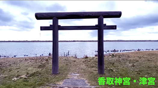


津宮というのは香取神宮「一の鳥居」と称されている。その場所は現在の「利根川」に面して建てられている。水辺から上陸して神さまが渡御されるという故実に即している。
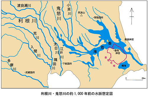
2番目の地図は先般来、このシリーズで紹介してきた古地図で、約1000年前の古地形を表現したもの。香取市がまとめている「第1章 香取市の歴史的風致形成の背景」PDF書類に掲載されている。
地元紙「千葉日報」記事では以下の記述もある。〜内陸部である現在の利根川流域には「香取海」という大きな内海が広がっていた。その範囲は現在の霞ケ浦・印旛沼・手賀沼の辺りが一つにつながった広さ。香取海は縄文時代から水上交通が盛んだった。飛鳥奈良期には香取海の千葉県側に印波国・下海上国(しもつうなかみのくに)茨城県側に筑波国・仲国・茨城国があり、沿岸には多くの古墳が造られた。香取海は朝廷が東国を支配する上で重要な役割があった。日本書紀や常陸国風土記にはヤマトタケル東征の際に香取海を渡ったと思われる記述がある。香取神宮(香取市)と鹿島神宮(鹿嶋市)の二社は香取海入口の対岸にあり、蝦夷の平定神として崇拝され、前社は下総国、後社は常陸国の一宮に位置付けられた。〜
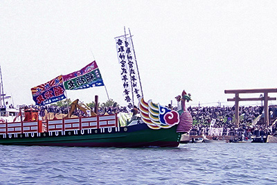
3番目の写真は鹿島神宮と同様に香取神宮でも、このような水上を神さまが渡御されるイベント「式年神幸祭」が12年に一度の午年4月15・16日の両日に掛け行われる。古代地形を踏まえれば、このような渡御式典が、古い「東海道」というメインルートが上総ー下総ー常陸であり、この香取の海が関東の最重要地域だったことを裏付けているのだと思う。だから、対岸同士に香取と鹿島という2社が蟠踞したのだろう。ヤマト王権として伊勢と、この2社を最高神格として祀ってきたことの蓋然性が表れている。
それと、日本の神社信仰ではこのように八百万の神々は非常にアクティブだと目を見張らせられる。この2社がともに武神であることと相関しているのだろうか。やはり対蝦夷への出撃拠点地域として歴史年代を通しての関東地域の役割を象徴もしているだろう。

津宮から香取神宮神域までのルート途次に「神道山古墳群」を遙拝しながらの道が宮道として妥当性を感じる。この道をたどると3.2kmとほぼ常識的。神道山古墳群は前方後円墳1基(全長46m高さ4m)円墳11基からなる古墳時代後期の古墳群で1928(昭和3)年、考古学研究者の吉田文俊により発見された。香取神宮所管地域だという。
一方で香取神宮の東南約7kmに前方後円墳が集中する「城山古墳群」がある。その1号墳(6世紀後半?)からは中国製の三角縁神獣鏡(下総で唯一の出土例。)や環頭太刀4振など大量の副葬品が出土した。このため古墳の主は下海上国造ではとみられている。
どうも龍角寺古墳群とそれ以前の古墳群との対比のようにも思える。ヤマト王権と地域権力の間での葛藤、結果として「新興武力勢力」が支配権を握ったとも推測できる。ヤマト王権の東国支配の実相、興味深い。
English version⬇
Landing at Tsumiya from the Sea of Katori, Katori Jingu Shrine (1): Exploring the Three Shrines of Eastern Japan – 15
The sea of Katori appeared as an important area in Yamatotakeru’s eastern expedition. The most important “sea route” to Kashima on the opposite shore. From Ichino-torii and Tsumiya to Jingu Shrine. The first torii, Tsumiya, to the shrine
Tsumiya is called the “first torii” of Katori Jingu Shrine. It was built facing the present-day Tone River. This is in line with the legend that the gods would come ashore from the water’s edge.
The second map is an old map that I have been introducing in this series, showing the ancient topography of about 1,000 years ago. It is shown in the PDF document “Chapter 1: Background of the Historical Landscape of Katori City” compiled by Katori City.
The local newspaper “Chiba Nippo” article also includes the following description 〜The present Tone River basin, which is the inland area of the city, had a large inland sea called “Katori-kai”. The area is as large as the present Kasumigaura, Inba-numa, and Teganuma swamps. Water traffic on the Katorikai has been active since the Jomon period. In the Asuka-Nara period, there were the provinces of Inba and Shimotsunakami on the Chiba side of the Katori Sea, and Tsukuba, Naka, and Ibaraki on the Ibaraki side, and many ancient tombs were built on the coasts of these provinces. The Katori Sea played an important role in the Imperial Court’s control of the eastern provinces. The Chronicles of Japan and the Fudoki of Hitachinokuni describe the crossing of the Katori Sea during Yamatotakeru’s eastern expedition. The two shrines, Katori Jingu (Katori City) and Kashima Jingu (Kashima City), are located on opposite sides of the entrance to the Katori Sea, and were worshipped as deities for the pacification of the Emishi, with the former shrine positioned in Shimousa Province and the latter shrine in Hitachiniku Province. ~.
The third photo shows Katori Jingu Shrine as well as Kashima Jingu Shrine, where the “Shikinen Shinko Matsuri,” an event in which the deities are ferried across the water, is held once every 12 years on April 15 and 16 in the year of the Noon. Based on the ancient topography, such a procession ceremony confirms that the main route of the old Tokaido Highway was Kamisusa-Shimosusa-Jochiriku, and that the sea in Katori was the most important area in the Kanto region. This is probably why Katori and Kashima were coiled on opposite banks of the sea. This shows the probability that the Yamato royal authority enshrined Ise and these two shrines as the supreme deities.
Also, it is eye-opening to see that in Japanese shrine worship, these eight million gods are very active. Is this correlated with the fact that these two shrines are both warrior deities? The Kanto region’s role throughout history as a base area for launching offensives against the Emishi may also be symbolic of this.
The route from Tsumiya to the Katori Jingu Shrine, with a visit to the “Jindozan tumulus group” at the end of the route, seems reasonable as a palace path. The distance along this path is 3.2 km, which is almost reasonable. The Jindozan tumulus group is a group of tumuli from the late Kofun period, consisting of one 46-meter-long (4-meter-high) round tumulus and 11 circular tumuli. The area is said to be under the jurisdiction of Katori Jingu Shrine.
On the other hand, about 7 km southeast of Katori Jingu is the “Shiroyama Kofun Tumulus Group,” a cluster of posterior frontal round mounds. The first burial mound (late 6th century?) was found to contain a Chinese-made triangular-rimmed The first burial mound (late 6th century?) contains a Chinese triangular-rimmed animal and animal mirror (the only one excavated in Shimousa), four sword blades with ring heads, and other items. The burial mound No. 1 (late 6th century?) has a large number of burial accessories, including a Chinese triangular-rimmed mirror (the only one found in Shimousa) and four ring-headed swords. For this reason, the tomb is thought to have been owned by the Shimo-Kaijo-Kokuzo clan.
This seems to be a contrast between the Ryukakuji tumulus group and earlier tumulus groups. It can be inferred that the conflict between the Yamato Royalty and regional powers resulted in a “newly emerged military power” taking control of the region. The reality of the Yamato kingdom’s control over the eastern part of Japan is interesting.
Posted on 8月 20th, 2023 by 三木 奎吾
Filed under: 日本社会・文化研究, 歴史探訪


コメントを投稿
「※誹謗中傷や、悪意のある書き込み、営利目的などのコメントを防ぐために、投稿された全てのコメントは一時的に保留されますのでご了承ください。」
You must be logged in to post a comment.