
さてきのうは、アタマのなかが疾風怒濤のような状況(笑)。2−3ヶ月掛かっていた作業の大詰めの段階にようやく「一段落」感が得られました。
そういう状況最中ではとくにブログの執筆作業などがいちばん難易度が高くなってしまう。なんといってもアタマのなかに「スキマ」がなかなかないのですね。もう満杯なんですけどなにか、みたいな状況。
毎日書き続けているので、普通はあるテーマでの「連載」的な大きなテーマ設定を決めて、そこから深掘り的に分析していくという段取りをしていくケースが多いのですが、そういう整理整頓作業のようなアタマのなかの領域が、ほぼ満杯になって活動を自動停止するようなのです。
なのでなるべくワンテーマ的なもので「毎日更新」を絶やさないように継続させることになる。
わたしの場合、料理とかはそうした労働作業との補完的相性が良くて、気分転換の役割を果たしてくれている。アタマ満杯になってくると「あ、あの料理作っておくかな」と別系統のスイッチが入るようなのですね。
おっと、ブログにはあんまり関係のない話題になっていきそうでマズイ(笑)。
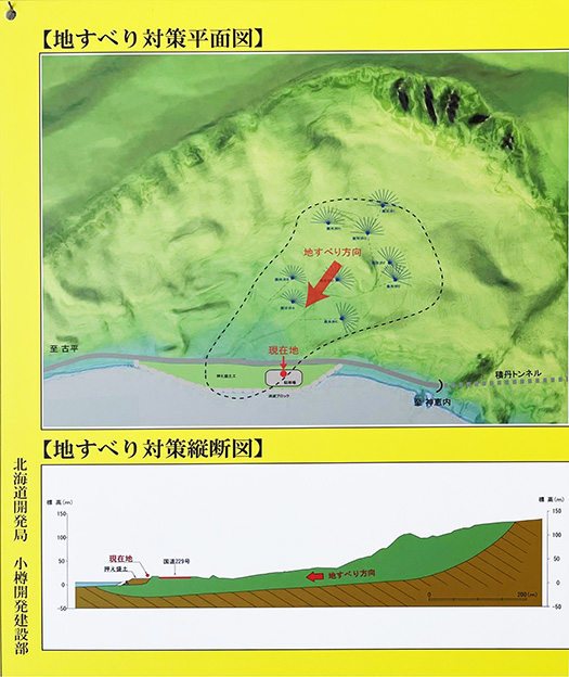
本日は先日の積丹半島ぐるっと旅の途中で出会った「地滑り地形」の典型的地域のこと。
上の図は積丹町の海岸地域にある北海道開発局・小樽開発建設部による説明板であります。「沼前地すべり」と命名されているけれど、地名の詳細は書かれていない。文章を要約すると以下。
「地すべりとは 地すべりとは山地や丘陵の斜面が比較的広い範囲にわたってすべり出す現象のことです。地すべりにはゆっくりとした滑動が長期間続くものが多く、中には断続的なすべりが数十年にわたるものもあります。「沼前」地すべりは、海岸浸食を起因とし、長期にわたって滑動していましたが、地価水位上昇により活発化しました。規模が大きく、全国有数の地すべりと言えます。」
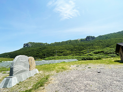
おお、であります。ぐるっとこの地形に囲まれているので写真撮影も出来ない。
で、年表を見ると、昭和7年頃から記録がされていて、すでに90年以上の経過が記録されていることになる。ここに来られる国道229号線の開通が1996(平成8)年ということで、2001年になって駐車した駐車場が開設利用されたということ。前に一度くらいは来ているかどうか、不明ですが、今回はこういう案内板を確認することができた。すごい。
高校時代、まったく事前勉強していない学力試験で「地学」だけは優秀な成績を得た成功体験を持つわたしとしては、久しぶりにアタマが活性化した次第。
English version⬇
Shakotan Peninsula “Landslide” topography area
A signboard that was quietly hanging on the wall of a restroom in a parking lot where we stopped on the way to our car. It explains in an easy-to-understand manner the landscape topography that I had never seen before. Amazing. …….
Yesterday, my mind was in a whirlwind of activity, and I finally felt like I had reached the final stage of a project that had been taking 2-3 months to complete.
In such a situation, writing a blog is the most difficult work. After all, there is no room in my mind. It’s like, “I’m full, but what’s wrong?
Since I am writing every day, I usually set a major theme like a “series” on a certain topic, and from there, I often make arrangements to analyze it in depth.
Therefore, I try to keep “daily updates” on a single theme as much as possible.
In my case, cooking is a good complement to such laborious work and serves as a refreshing change of pace. When my mind is full, it seems to turn on a different kind of switch, saying, “Oh, I should make that dish.
Oops, this is going to be a topic that has nothing to do with my blog.
Today, I would like to talk about a typical “landslide landform” that I encountered during my recent trip around the Shakotan Peninsula.
The above figure is an explanatory board by the Otaru Development and Construction Department of the Hokkaido Development Bureau, located in the coastal area of Shakotan Town. It is named “Numamae Landslide,” but the details of the place name are not written. The following is a summary of the text.
A landslide is a phenomenon in which the slope of a mountain or hill slides over a relatively wide area. Landslides are often long-lasting, slow-moving slides, some of which may last for decades. The “Numamae” landslide was caused by coastal erosion and had been sliding for a long period of time, but became more active due to rising water levels. It is one of the largest landslides in the country.”
Oh, yes. I can’t even take a picture because I am surrounded by this terrain all the way around.
So, looking at the chronology, it has been recorded since around 1932, which means that more than 90 years have already passed. The National Highway 229 that leads here was opened in 1996 (Heisei 8), which means that the parking lot where we parked was opened and used in 2001. I am not sure if I have been here at least once before, but this time I was able to check this kind of information board. It was amazing.
As a high school student who had a successful experience of getting an excellent grade in “geology” in an academic test without any prior study, my mind was activated for the first time in a long time.
共有:

Posted on 6月 18th, 2024 by 三木 奎吾
Filed under: 日本社会・文化研究


コメントを投稿
「※誹謗中傷や、悪意のある書き込み、営利目的などのコメントを防ぐために、投稿された全てのコメントは一時的に保留されますのでご了承ください。」
You must be logged in to post a comment.