本文へジャンプ

【おきす⇒いきす&国内海運史・息栖神社③ 東国三社探訪-23】


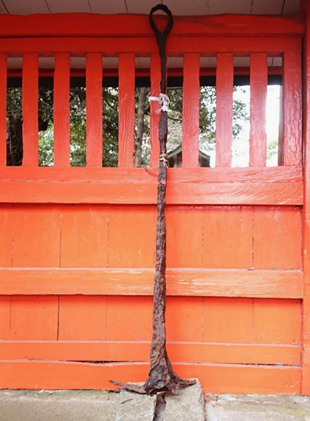
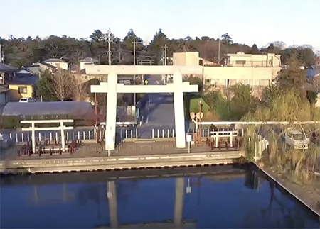
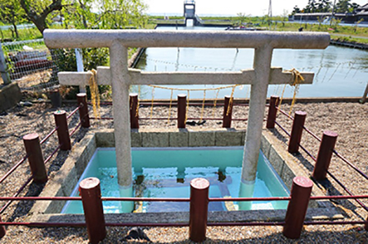
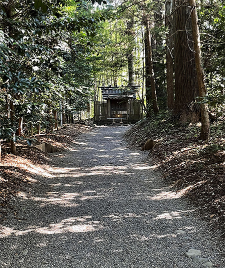
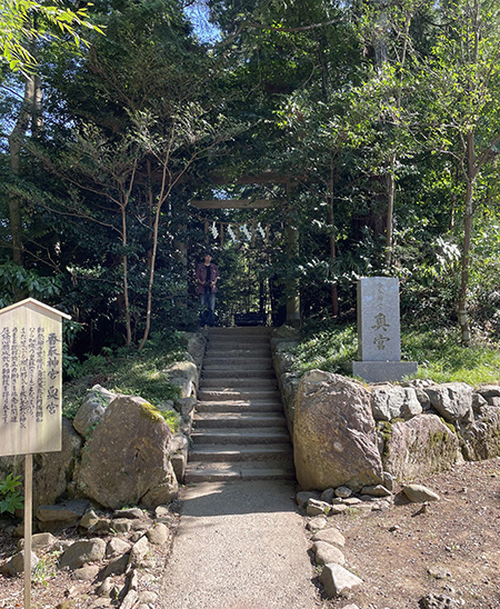
現地の息栖神社では不覚にもこの「碇」の存在に気付かず、説明板のついでに周辺を撮影した写真から今回いちばん上の写真を拡大・編集してみた。よく文章を読んでみたらこの目立たない「碇」が重要な役回りで港(津)であったこの息栖の地の素性を表していたことにあとで気付かされた。
どうも「息栖」という漢字表記の地名は一般的な日本語感覚からは想像しにくい。息という字はまさか地名とは思わず、つい「鳥」と無意識に見間違えて「とりす、かなぁ。ウイスキーみたいだ」というような無用な妄想誤解がアタマのなかに浮かんで収拾がつかない(笑)。
こういうのはわたしだけではなく多くの人がそう思うようです。
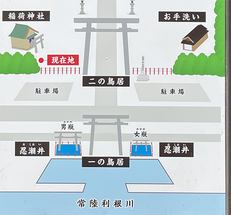
一方で「おきすの津」と古代に呼ばれていた地名はよくわかる。ストンと腑に落ちてくる表現。ではどうして「おきす」が「息栖」になったのか、調べてみても情報に巡り会えない。
そういう不条理感から、どうも地名に「海民」的な、原初的日本人言語感が投影されているのではないかと妄想が飛躍したりする。古日本語的な言語感覚があるようにも思えるのですね。この感覚は飛鳥地方とか、徳島県の山岳地域などにも通じるようなもの。その後の日本語は活発な「漢字文化」の導入によってその「音読み」「意味づけ」が主流になっていったのに対して、オリジナルな日本語の感受性を伝えてくれていると思えるのです。
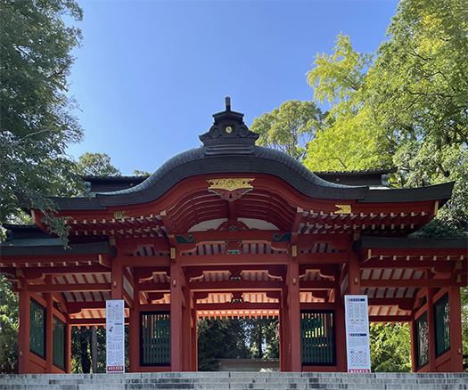
さらに、一説ではこの東国三社とは、ヤマト王権以前に関東〜東北に存在したとされる「日高見〜ひだかみ〜国」の根拠地に相当するのではないかとも言われる。
北海道にいるとアイヌ語由来の地名が非常に多いけれど、そういう言語感覚にも通底しそうな表現の仕方が投影されているとも思えてくる。

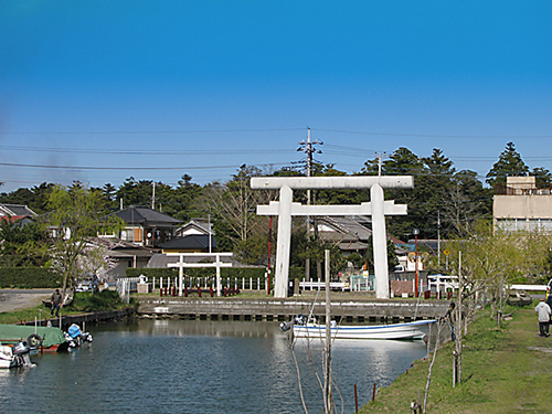
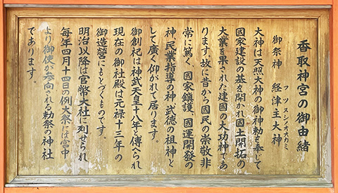
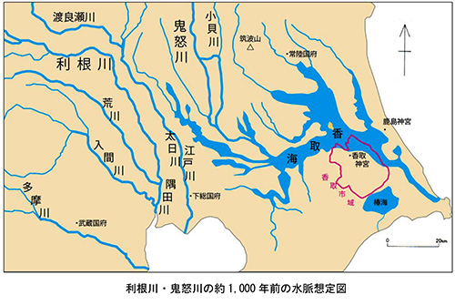
いずれにせよ、古関東の内海の港(津)であった息栖に関連して日本列島の国内各地間の太平洋側海上ルートを探ってみるけれど、なかなか明示的研究に突き当たらない。この息栖神社の解説説明板には以下の記述。
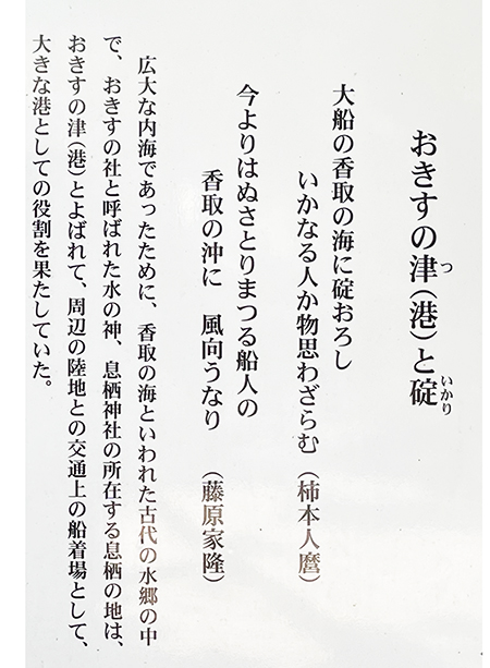
「徳川期になると幕府の拠点江戸と東北との交流が盛んになりその水上輸送路は、江戸川・利根川・水郷地帯・銚子河口から北上しての鹿島灘といった航路が選ばれていた。こうした長距離輸送には当然大型船舶が用いられ、往復途上で息栖神社は航海の安全祈願をしたとされる。」(要旨抜粋)
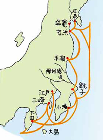
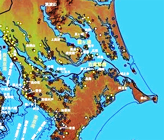
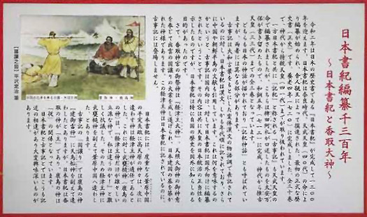
上の図は江戸期に消費都市江戸に20万石ほどの米を提供したといわれる仙台藩の安定的輸送ルートを諮問された先端的事業家・河村瑞賢が開拓した「東回り航路」図。<こちらは宮城県の公式資料「河村 瑞賢 -東廻り航路を拓く」より引用>
「これまでの海運では船が難破することが多い。仙台藩から江戸に到着するのに1年かかることすらある。」と相談されたかれが開発した。
しかし、奥州藤原氏の時代には愛知県常滑の磁器が威信材として、遠く北海道・厚真でも発掘されている。たしかに日本海側が国内物流の基本ではあったでしょうが、熊野水軍など太平洋側の物流輸送活動実態もある。海路の日本史、非常に奥行きのある世界だと思います。

English version⬇

Okisu ⇒ Ikisu & Domestic Shipping History, Ikisu Shrine (3): Exploration of Three Shrines in Eastern Japan – 23
Japanese History of Language Sense Transition. Is it a residue of the ancient Yamato language? What about the development process of domestic sea routes on the Pacific Ocean side from ancient times? The history of domestic maritime transport in Japan

I was unintentionally unaware of the existence of this “anchor” at the local shrine, so I enlarged and edited the top photo from the photos I took of the surrounding area while reading the explanatory board. After reading the text carefully, I realized later that this inconspicuous “anchor” played an important role in the identity of this place, which used to be a port (Tsu).
It is difficult to imagine a place name written in kanji characters as “breath” in the common Japanese sense. I did not think that the character for “breath” was a place name, and I unconsciously mistook it for “bird” and said, “Torisu, I wonder. It sounds like whiskey.
(Laughs.) This is not only me, but many people seem to think so.
On the other hand, I understand the name of the place called “Okisu-no-tsu” in ancient times. It is an expression that falls into place. But when I tried to find out why “Okisu” became “Ikisu,” I could not come across any information.
This sense of absurdity leads me to wonder if the place name might reflect a primitive Japanese linguistic sense like that of the “Kaimin” people. It seems to me that there is an old Japanese linguistic sense. This sense is something like that of the Asuka region or the mountainous areas of Tokushima Prefecture. It seems to me that it conveys an original Japanese sensibility, whereas the Japanese language since then has been dominated by its “sound reading” and “meaning making” with the introduction of an active “kanji culture.
Furthermore, one theory suggests that these three shrines in the eastern part of the country may correspond to the border line with the “Hidakami – Hidakami – Province,” which is said to have existed in the Kanto – Tohoku region before the Yamato Kingship.
In Hokkaido, there are many place names derived from the Ainu language, and I cannot help but think that such a way of expression that seems to be common to such linguistic sensibilities is also projected here.

In any case, I have been searching for maritime routes between the Japanese archipelago and other parts of Japan in relation to the ancient Kanto inland sea port (Tsu) of Suisu, but have been unable to come across any explicit research on the subject. The explanatory board at the shrine reads as follows.
The Edo River, the Tone River, the Suigo area, and the Kashima Sea route northward from the mouth of the Choshi River to the Kashima Sea were chosen for the water transportation routes. Naturally, large vessels were used for such long-distance transportation, and it is said that the shrine prayed for safe voyages on the way there and back. (Abstract excerpt)
The above chart shows the “eastbound route” pioneered by Kawamura Zuiken, a leading entrepreneur who was consulted on a stable transportation route by the Sendai clan, which is said to have supplied the consuming city of Edo with some 200,000 koku of rice during the Edo period. In the past, ships were often shipwrecked in shipping. It sometimes takes a year for a ship to reach Edo from Sendai. Takara, who was consulted by the Oshu Fujiwara clan, developed the map.
However, during the reign of the Oshu Fujiwara clan, porcelain from Tokoname, Aichi Prefecture, was excavated as prestige material, as well as in Atsuma, Hokkaido in the distant past. It is true that the Sea of Japan side was the basis of domestic distribution, but there were also activities on the Pacific side, such as the Kumano Suigun (navy). The history of Japan by sea is a world of great depth.

【列島海民のはるかな交流・息栖神社② 東国三社探訪-22】


鹿島や香取は海との関係はそれなりには感じるけれど、この息栖に至ってなぜ、東国三社というように言われ続けてきたのかのワケが腑に落ちてきています。
そもそもこの日本列島に現生人類が到達したのには海を渡って来たのでしょう。わたしたち日本人のルーツにはそういうDNAが深く宿っているのだと思う。「大工」という人間の仕事の最初期とは家や建築物を作ることではなく、船をつくることが本然の仕事、スタートだったとされる。船大工というのが始原に近く、家大工はそこから派生してきた存在なのだと言われる。
そして石器時代の昔からこうした船大工を束ねて日本列島地域に現生人類のいろいろな系統が多数、波状的に移住してきたというのが実態なのでしょう。この列島地域で世界有数の豊富な漁業資源とめぐり会って、海辺で定住した。
魚という、陸上動物とはまったく違う行動原理を持った狩猟対象と本格的に出会い、縄文集落という定住生活が始まった。日本の神社文化には、こうした悠久の記憶遺産が反映している部分が強い。
こうした民族意識の底流の海民的伝統、それへの素朴な帰依のこころがこの息栖神社のたたずまいからは立ち上っていると思える。写真は「一の鳥居」周辺、そこに湧き出る清水を祀る「男瓶」「女瓶」の小さな鳥居たち。まことに「海民」のための神宿る地なのでしょう。
一方でアマテラス系のヤマト王権は「葦原の中つ国」という米作適地でのコメ生産を主導する文化体系をこの列島に持ち込んで、殖産興業と人口増加を実現させてきたように思っている。
そういう東アジア的農耕文化と、先述した海民文化とが、排他的ではなく「和の国」として平和共存を目指して日本社会は建国されてきた流れが強いのではと感じています。

こうした古代からの海民伝統の聖地として東国三社は尊崇されてきたのではないか。
上の写真は息栖神社境内に置かれた説明板。
「大船の香取の海に碇おろし、いかなる人か物思わざらむ<柿本人麻呂>」
「今よりはぬさとりまつる船人の、香取の沖に風向かうなり<藤原家隆>」という2句。
〜広大な内海であったために香取の海と言われた古代の水郷のなかで、「おきすの社」と呼ばれた水の神、息栖神社のある息栖の地は「おきすの津(港)」と呼ばれていた。<中略>〜
600-700年代の歌人の歌は、当時の古代地形とそのなかでの息栖神社のたたずまいを浪漫的に伝えてくれる。はるかな船旅の末にこの地に来訪した柿本人麻呂さんは、たぶん船主が風を読んでいる様子をみながら、その場の空気感を描写してくれている。また、ぬさ〜幣帛。ごへい〜をかざして船旅の安全を祈願している様子は、古代の交通をあきらかにしてくれる。ため息が出るようだ。・・・

<この歌は息栖神社境内に説明があり、当然この息栖神社前の「香取の海」を歌ったものとリードされましたが、飛鳥の柿本人麻呂たちが謳ったのは近江の「香取海」という説もあることを注記します。>

English version⬇

Far-flung exchanges between the archipelago’s sea people and the breath shrine (2) Exploration of the three shrines in the eastern part of Japan – 22
Asuka poets convey the atmosphere of breath to the present day. The simple nature worship of the sea people, who prayed for the safety of ancient traffic. The shrine is a place of

While Kashima and Katori have a certain relationship with the sea, the reason why they have been referred to as the “Three Shrines of the East” is becoming clear to me now.
It is likely that the present-day humans arrived in the Japanese archipelago by crossing the sea. I believe that the roots of the Japanese people are deeply imbued with this kind of DNA. It is said that the earliest work of a “carpenter” was not to build houses or buildings, but to build ships. It is said that ship carpentry was close to the origin of carpentry, and house carpentry was derived from it.
The reality of the situation is that many different lineages of present-day humans migrated to the Japanese archipelago region in waves, uniting these ship carpenters since the Stone Age. In this archipelago region, they encountered one of the world’s richest fishery resources and settled down by the sea.
They encountered in earnest fish, a hunting target with behavioral principles completely different from those of land animals, and began a settled lifestyle known as the Jomon settlement. The culture of Japanese shrines reflects the legacy of this long-standing memory.
The simple devotion to the traditions of the seafaring people, which are at the bottom of our national consciousness, can be seen in the appearance of the shrine. The photo shows the area around the Ichino-torii (first torii), and the small torii (male and female) that enshrine the fresh water that gushes out of the torii. It is truly a place where the gods dwell for the “sea people.
Of course, I believe that the Yamato kingdom of Amaterasu lineage brought to this archipelago a cultural system that led rice production in the “reed field of Nakatsukuni,” a land suitable for rice cultivation, and realized reproduction, development, and population growth.
I feel that there is a strong trend toward a peaceful coexistence of such East Asian agricultural culture and the aforementioned seafaring culture as a “country of harmony” rather than exclusivity.

I believe that the three shrines in East Asia have been revered as sacred sites of such ancient maritime people’s traditions.
The photo above is an explanatory board placed in the precincts of the shrine.
The above photo is a signboard placed in the precincts of the shrine.
The two phrases are: “The boatman who now more than ever will be at the Nusatori Festival is heading into the wind off the coast of Katori.
〜The ancient water village of Katori was called “Katori no Umi” (Katori Sea) because of its vast inland sea, and the place where the god of water, the breath shrine, is located was called “Okisu no Tsu (port). <Omission.
Poems by poets of the 600s and 700s romantically convey the ancient topography of the time and the appearance of the Ikisu Shrine in the midst of it. Kakinomotojinmaro, who came to this place after a far journey by boat, probably saw the boat owner reading the wind and described the atmosphere of the place. Also, nusa ~ hibaku. The scene of the boatman praying for the safety of the boat’s journey by holding up the nusa – gohei – reveals the ancient traffic. It makes me sigh. The shrine is a place of

【古代地形とナゾの海神・息栖神社① 東国三社探訪-21】


さて東国三社と呼ばれる鹿島神宮、香取神宮、そして若干スピンアウトして蘇我氏の関係する龍角寺とみてきましたが、このシリーズ最後はナゾに包まれた息栖神社であります。
事前にわかる資料もほとんどなく、歴史好きの興味で「東国三社といわれているし・・・」程度のノリで探訪させていただいたのですが、実際に現地を訪問してその実感を踏まえて再度探索をはじめて見ると、「おお、あの事実はこういった背景から生成したことなのか」と驚かされることばかり。関東との縁がふたたび濃厚になって、この日本最大の平野地帯の地形変容ということについての理解、正確な把握が迫られてきていることに気付かされる次第。
必ずしも大和平野、京都大阪での日本史だけが悠久なのではないということか。
上の図は、いまの息栖神社のマップと縄文期の海進のなかでの古代地形推計。眼前には香取の海、霞ヶ浦、古鬼怒湾といった内海が広がっていた古代風景が見えてくる。息栖神社というのは古代地形からみれば海上交通の要衝地であったことが推測できてくる。とくに太平洋を介して東北地域とヤマト政権支配地域との物流・移動を考えれば、最前線的な位置であると知れてくる。


そういう気付きに踏まえて現地での探訪体験を重ね合わせると、なにげに見ていた「忍潮井(おしおい)」と呼ばれる2つの井戸の記憶が湧き上がってきた。こういった縄文海進の痕跡と重ね合わせれば、古代の海上交通での最大の生命線・必需品、飲料水のことが雷鳴のごとくに納得感として襲ってくる。
この湧き水は伊勢の明星井(忍塩井)、山城(京都・伏見)の直井とともに日本三霊水の一つとされる。神社のHPを見ると以下の記述(要旨)。
〜常陸利根川沿いにある一の鳥居の両脇に小さな鳥居の建てられた二つの四角い井戸「忍潮井(おしおい)」があります。男瓶(おがめ)と女瓶(めがめ)と呼んでいます。忍潮井は194年に造られ2000年近く清水を湧き出し続けてきました。辺り一面が海水におおわれており、真水(淡水)の水脈を発見し噴出させたところ、辺りの海水を押しのけて真水が湧出したことから、忍潮井の名がつけられました。水と人類との関わりの中で最も古いかたちの井戸です。女瓶の水を男性が、男瓶の水を女性が飲むと二人は結ばれるという言い伝えがあり、縁結びのご利益もあるとされます。〜
日本海の航海と違って荒波で知られる太平洋航路でようやく波穏やかな内海に入ってほどなくのこの息栖の地で、この清水にめぐり会った人びとは、大いにこの地のありがたさに感動させられ、この地には「神宿る」とその神性を感受したことだろう。
この列島に生きてきた人間として、そういう自然への原初的帰依は激しく理解できる。

English version⬇

Ancient Landforms and the Riddle of the Sea God, the Ikisu Shrine (1): Exploring the Three Shrines of Eastern Japan – 21
A node of maritime traffic and logistics in an archipelagic society. A strategic point between the Yamato regime-controlled area and Northeastern Japan. A place where fresh water, where the god resides, springs from. The shrine is a place where the gods dwell.

We have already visited the three shrines in the eastern part of Japan, Kashima Jingu Shrine, Katori Jingu Shrine, and, slightly spinning out, Ryukakuji Temple, which is related to the Soga clan.
I visited the shrine with little information beforehand, and with only a casual “it is said to be one of the three shrines in the eastern part of Japan…” out of historical curiosity, but when I actually visited the shrine and began my search again based on that experience, I was surprised to find that “Oh, so this is the background that led to that fact. I was surprised at the fact that it was generated from such a background. As my connection with the Kanto region has grown stronger, I have come to realize that I must now understand and accurately grasp the topographical transformation of Japan’s largest plain area.
It may be that the history of Japan is not necessarily limited to the Yamato Plain and Kyoto-Osaka area.
The above figure shows a map of the present-day Ikosu Shrine and an ancient topographic map of the Jomon period in the midst of the sea advance. In front of our eyes, we can see the ancient landscape of inland seas such as the Katori Sea, Kasumigaura, and Ko-Kinu Bay. The ancient topography of the shrine suggests that it was a strategic point for maritime traffic. In particular, it was a frontline location for the distribution and movement of goods between the Tohoku region and the Yamato regime-controlled areas via the Pacific Ocean.

When I took this realization into account and superimposed it on my exploration experience at the site, memories of two wells called “Oshioi,” which I had casually observed, began to well up. When superimposed on these traces of the Jomon sea advance, the idea of drinking water, the greatest lifeline and necessity of ancient maritime traffic, hit me like a thunderclap of conviction.
This spring water is considered one of the three sacred waters of Japan, along with Meisei well (Oshioi well) in Ise and Naoi well in Yamashiro (Fushimi, Kyoto). The shrine’s website gives the following description (summary).
〜˜There are two square wells called Oshioi (Oshioi) with small torii gates built on either side of the first torii gate along the Hitachi-Tone River. They are called Ogame (male bottle) and Megame (female bottle). Oshioi was built in 194 and has been producing fresh water for nearly 2,000 years. The entire area was covered with seawater, and when a vein of fresh water (freshwater) was discovered and gushed out, the fresh water gushed out, pushing aside the seawater in the area, hence the name Oshioi Well. This is the oldest well in the relationship between water and humankind. According to legend, if a man drinks the water from the woman’s bottle and a woman drinks the water from the man’s bottle, the two will be united, and the well is said to bring good luck in marriage. 〜The water in the male bottle is said to be good for marriage.
Unlike voyages on the Sea of Japan, those who encountered this fresh water in the Pacific Ocean, known for its rough seas, must have been greatly moved by the gratitude of this place, and must have felt the divinity of this place, as if a god resided here.
As a person who has lived on this archipelago, I can understand this primordial devotion to nature.

【素朴な神性「奥宮」・香取神宮⑥ 東国三社探訪-20】


香取神宮の「奥宮」は荒魂というように言われる。荒魂は神の荒々しい側面、荒ぶる魂である。経津主大神の勇猛果断、義侠強忍等に関する妙用とされる。先日触れた拝殿そして本殿の江戸文化最盛期の爛熟デザインに対して、こちらは古格な神さまの素性を正直に表しているようで、ぐっと心を奪われる。
現在の社殿は、昭和四十八年伊勢神宮御遷宮の折の古材に依るものとされている。式年遷宮による建て替えでの古材がこのように生まれ変わるのは、いかにも古来からの伝承性、魂の継続性を感じさせてくれる。

神々のデザインには好みのようなものがあるのでしょうが、一定の自然豊かな神域を定めて、公園のような環境を作りそこを身分の上下なく自由に参観させる、そしてその背筋を「きよらかにさせる」という民族文化を継続してきていることは、日本の特質なのだと思わせる。
わたし的にはこういう神性に対して、本来の日本人のこころを感じさせられる次第。
周辺環境との調和、全体としての空間デザインマインドというものの日本的コア部分なのではないか。こういうデザイン論が基本的な感受性を支配していると思う。
「荒ぶる魂は邪気を払い霊妙な神気のもと、破邪顕正の働きも活発に開運、厄除け、心願成就のご加護」云々という説明が添えられていて微笑ましい。


香取神宮にも鹿島神宮同様に「要石」が配置されている。上の写真は「要石を背負うナマズ」の絵図で、この武神が鹿島の神と連携して関東の大地震を押さえつけているのだという(笑)。歴世に渡って関東地域一帯は地震被害が続発していたことを表している。
そうであるからこそ、鹿島も香取も武神が守るという日本的信仰心が育っていったのだとも思える。日本民族にとって関東の地域は大きな開発フロンティアであり、地震多発地帯という困難も抱える中で、利根川東遷などの人為的努力が継続的に投入されてきた。
そのような歴史時間での「民族体験」がこの東国三社のうちの主要2社には込められている。そこからさらにわたしの暮らす北海道の開拓という歴史体験に日本社会は向かっていくことになる。東北地域は「征夷」という対象に挙げられた不幸な歴史を背負って来たけれど、しかし北海道ではそのような経緯はなかった。ただひたすらに寒冷であるという条件に対して、生存環境的進化、住宅性能の向上が不可欠とされた。
ナマズの地震多発地帯という関東フロンティア体験はこうした戯画を生んだけれど、さて北海道の高断熱高気密住宅創造体験からは、どんな戯画化が生成していくだろうか。
いまのところ、北海道神宮にはそのような民族体験の形象化は見られないけれど(笑)。

English version⬇

Katori Jingu Shrine (6): Exploring the Three Shrines of Eastern Japan – 20
The space is an architecturally designed representation of the fierce spirit of the god of worship, Kyotsu-no-okami. The construction materials are recycled from the old materials used for the ceremonial relocation of the Ise Jingu Shrine. It is a very “Arakotama” (spirit). The building is designed by the architect, Mr. K. Kikuchi, who is also the director of the building.

The “Okumiya” of Katori Jingu Shrine is said to be called Arakotama. Arakotama is the wild side of God, or the soul that rages. It is said that it is a strange symbol of the god Kyotsu-no-okami’s valor, chivalry, and perseverance. In contrast to the mature design of the hall of worship and the main hall of the shrine, which I mentioned the other day, this shrine seems to honestly express the nature of the ancient god, and is captivating.
The present shrine pavilions are said to have been built using old materials from the Ise Jingu Goshengu in 1973. The fact that the old timbers were used for the reconstruction of the shrine during the ceremonial relocation of the Ise Jingu shrine gives one a sense of the continuity of the ancient tradition and spirit of the shrine.

Although there may be some preferences in the design of deities, the fact that Japan has continued to maintain a national culture of designating certain nature-rich sacred areas and creating park-like environments where people of all ranks are allowed to freely visit, and where people’s backs are made to stand upright, makes me think that this is a characteristic of the Japanese people.
In my opinion, this kind of divinity makes me feel the true spirit of the Japanese people.
I believe that this is the core of the Japanese mindset of spatial design as a whole, in harmony with the surrounding environment. I believe that this kind of design theory dominates the basic sensitivity.
The explanation that “the souls of the wild spirits are under the influence of a mystical spirit that dispels evil spirits, and the work of breaking evil and manifesting righteousness is also active to bring good luck, ward off bad luck, and fulfill one’s desires” is very funny.

Like the Kashima Jingu Shrine, the Katori Jingu Shrine also has a “keystone” in place. The photo above is a drawing of a “catfish carrying a keystone,” and it is said that this warrior god is holding back a major earthquake in the Kanto region in cooperation with the god of Kashima (laugh). It represents the fact that the Kanto area and its vicinity had suffered a series of earthquake damage over the past generation.
It seems to me that this is why the Japanese belief that the god of war protects both Kashima and Katori grew up. For the Japanese people, the Kanto region was a great development frontier, and human efforts, such as the eastward shift of the Tone River, were continuously invested in the region, despite the difficulties of being an earthquake-prone area.
The “ethnic experience” of such a historical period is contained in these two major shrines of the Three Eastern Provinces. From there, Japanese society will further move toward the historical experience of the development of Hokkaido, where I live. While the Tohoku region has had the unfortunate history of being singled out as the target of “barbarian conquests,” this was not the case in Hokkaido. The cold conditions of the region made it essential for the evolution of the survival environment and the improvement of housing performance.
The Kanto frontier experience of earthquake-prone catfish has given rise to such caricatures, but what kind of caricatures will be generated by the experience of creating highly insulated and airtight housing in Hokkaido?
At the present time, we do not see such a caricature of ethnic experience in the Hokkaido shrine (laugh).
The explanation that “the souls of the wild spirits are under the influence of a mystical spirit that dispels evil spirits, and the work of breaking evil and manifesting righteousness is also active to bring good luck, ward off bad luck, and fulfill one’s desires” is very funny.

【武神の本殿建築と装飾性・香取神宮⑤ 東国三社探訪-19】


明治以前まで全国の神社の中で「神宮」という名称を託されていたのは、伊勢と香取・鹿島の3社のみ。
神社建築の場合は祀られる神さまが鎮座される建築が「本殿」であり、それに対して参詣する場が「拝殿」ということになる。一般的な神社建築ではこのふたつは一体的だと思う。わたしが毎日のように参拝する北海道神宮でも拝殿の奥に本殿が連続している。この香取神宮でも同様のスタイルで、拝殿の奥に本殿があって建築的には「繋がって」連棟形式で建てられている。鹿島神宮では本殿は令和の建て替え工事中で仮囲いされていたけれど、建築スタイルとしてはこの香取と同様に連棟形式が採用されていた。
デザイン傾向として、どちらも建築時期である江戸期の独特に進化した装飾形式が取られている。鹿皮のような色をした桧皮葺の屋根に黒塗り壁面が特徴。
一方、伊勢神宮では本殿は完全分離して外宮では拝殿という建築はなく、簡素な本殿建築が敷石平面の上に建っているだけでそれを仰ぎながら遙拝する形式。つくりが簡素なだけに式年遷宮という建て替えが歴史年代、一時期の衰退はあったけれど、ほぼ継続されてきた。
勅祭社らしく香取神宮本殿では屋根の飾りとして金細工で菊の紋章があしらわれ、その下の破風飾りにも金細工が施されて黒い本体着色と対比的で目を奪う装飾性を感じさせる。武神ということでもっと武骨なデザインがと思うけれど「目を奪う」という方向に向かっているように感じられる。オシャレに目覚めた武神か。
江戸期の日本社会というのは建前上は武断政治的だけれど、ながく平和が続いたことで武神というもののイメージもそのように変容していったものだろうか。香取神宮の周辺環境もまた変貌している。利根川東遷という大土木事業が成功して「香取の海」が縮小して利根川河川に変貌したのと対応しているとも感じる。

こちらは香取神宮の神宝・国宝海獣葡萄鏡。香取神宮の創建は神武18年とされてそれは確認しようもないが,
この神宝は正倉院にも同様の宝物が全5点あるという。そのなかで正倉院南倉9号収蔵品と同型とのこと。正倉院の創建は西暦756年だから、少なくともその頃にまで香取神宮の来歴は遡れることになる。
「鏡径29.7㎝。界圏は刳り込み形。鈕は伏獣形で鬣と背骨を表現し、口に小鹿を咥える。内区の獣には有角狻猊や獅子が表され、その周囲に小獣13匹が表され、それぞれの様相も様々である。帯圏上に外区の葡萄文が伸びて葡萄紋と柘榴瑞果紋が表され、その間に小禽・昆虫が表現される。外区は8禽8獣が右旋回で表され外縁帯は雲花紋とパルメット紋が混合した唐草文。鏡形が大きくひとつの完成形ともいえる。」
関東を治める神格としてこうした神宝がその格式を表現。ただこの鏡を見てオシャレに目覚めたか。

English version⬇

Katori Jingu Shrine 5: Exploration of Three Shrines in Eastern Japan – 19
The same objects as the Shosoin treasures are the sacred treasures. The Shosoin treasures are the same as the Shosoin treasures, cutting-edge artifacts imported through trade with the Tang Dynasty. The Takejin also cared about the appearance of these treasures (laugh)…

Before the Meiji era, only three Shinto shrines in Japan, Ise, Katori, and Kashima, were entrusted with the name “Jingu” (Shrine).
In the case of shrine architecture, the “hon-den” is the building where the deities are enshrined, and the “haiden” is the place of worship where visitors pay homage. In general shrine architecture, these two are considered to be one and the same. At the Hokkaido Jingu Shrine, which I visit every day, the main hall is located behind the worship hall. The Katori Jingu Shrine has the same style, with the main hall behind the worship hall, and the two are architecturally “connected” and built in a series of buildings. At Kashima Jingu, the main hall was temporarily enclosed during the reconstruction of 2021, but it was built in the same style as this Katori shrine, in a series of linked buildings.
The design trend in both buildings is the uniquely evolved decorative style of the Edo period (1603-1868) when they were built. The roof is cypress bark thatched with a color similar to deer skin, and the walls are painted black.
On the other hand, in Ise Jingu, the main shrine is completely separated from the outer shrine, and there is no worship hall in the outer shrine, but only a simple main shrine built on a paving stone level, which is worshipped while looking up to it. Because of the simplicity of the structure, the shrine has been reconstructed in the form of shikinen sengu (ceremonial relocation of the shrine) for most of its history, although there was a decline for a period of time.
As is typical of an imperial shrine, the main hall of Katori Jingu Shrine has a gold-work chrysanthemum crest as a roof decoration, and the gable below it is also decorated with gold work, which contrasts with the black coloring of the main body, creating an eye-catching decorative effect. The gold work on the gable below the chrysanthemum crest is also gold-plated, contrasting with the black coloring of the main body, and creating a sense of eye-catching ornamentation. Is this a god of war who has awakened to fashion?
Japanese society during the Edo period was, by its very nature, a military-dominated society, but the image of the warrior gods may have changed as peace continued for a long period of time. The environment surrounding the Katori Jingu Shrine has also changed. I feel that this corresponds to the success of the great engineering project of the eastward shift of the Tone River, which caused the “Katori Sea” to shrink and transform into the Tone River.

This is the Katori Jingu Shrine’s sacred treasure, the National Treasure Kaiju Budo Kagami (mirror of sea beasts and grapes). The Katori Jingu Shrine was founded in the 18th year of the Jinmu period, although there is no way to confirm this.
This is the same treasure as five other treasures in the Shosoin Repository. Among them, this treasure is said to be the same type as the one housed in Shosoin’s Nanzang No. 9. The Shosoin was built in 756 A.D., which means that the history of Katori Jingu can be traced back at least to that time.
The mirror is 29.7 cm in diameter. The mirror is 29.7 cm in diameter, with a gouged-in outer circle. The knob is in the shape of a beast with a mane and backbone, and a fawn in its mouth. The inner category of beasts includes an antlered eminence and a lion, surrounded by 13 smaller beasts, each of which has a different aspect. The grapevine pattern on the outer section extends above the band and is surrounded by a grape and boxwood pattern, with small birds and insects between the grape and boxwood patterns. The outer band has an arabesque design with a mixture of cloud and flower patterns and palmetto patterns. The large mirror shape can be said to be one of the most complete forms.
As the deity that ruled the Kanto region, these treasures expressed his prestige. But did this mirror awaken your sense of fashion?

【キッチュな元禄建築「拝殿」・香取神宮④ 東国三社探訪-18】


楼門を抜けると、香取神宮の拝殿がまっすぐ参詣者の眼前に現れる。三角形の破風と、さらにその下にはまろやかなカーブを見せる唐破風がわたしたちを引き寄せてくれる。香取神宮の前に鹿島神宮を参拝しているわたしからすると、鹿島神宮の古格な「奥宮」の簡素な深遠さとは異質なデザイン感覚。
いかにも江戸期(元禄13)1700年建築という時代相がそのまま表れたような空気感に包まれる。どうしてこのような表現が隆盛したか、神さまには申し訳ないが自分的にはちょっと違和感が募ってくる。

これが2−3年前に建て替えられる前の鹿島神宮・奥宮。コケのエッジもいかにもゆかしさを強調している。ちなみにこれは家康時代に寄進された建築。
一方の上の写真の香取神宮拝殿・本殿は5代徳川将軍が寄進した建築なので、幕府の「威光を示す」的な表現意図から、いかにも江戸期文化爛熟期の感覚が投影されたものなのでしょう。この香取にも奥宮はあってあとで紹介しますが、それはそれでいい(笑)のですが・・・。
多様な感受性を通史的に体験できる現代日本人としては、こちらの鹿島・奥宮の方がデザイン表現としては親和性を感じる。しかし徳川初期とは、たぶん参詣者の数もうなぎ上りになってそれなりの拝殿として巨大さが求められコケ脅かし的な要素も必要になったのか。江戸期の一般大衆への訴求として、奥宮の時代とは人心も変化した時代には、こういう表現が求められたのでしょう。

こちらの写真は「本殿」建築の「蟇股〜かえるまた」のキッチュデザイン。こういった木造建築の構造補強材には日本的なデザイン感覚集積の推移がある。
蟇股は仏教伝来のとき、寺院建築の建築様式として入ってきたもので屋根荷重を受ける補強材。建築構造上必要部材の一つでしたが、やがて日本人好みで装飾化。もちろん中国や韓国の寺院建築にもある部材ながら、ここまで装飾化していくのは日本独自の発展とされる。以下に時代変化ぶり。
奈良時代:とにかく分厚くがっちり
平安時代:ちょっと飾り的な要素が出てくる
鎌倉時代:透かし彫りなどの加工がされる
室町・安土桃山:彫りと曲線が特徴
江戸時代前期:きらびやかな彩色と彫刻
江戸時代後期:彫刻技術が飛び抜ける
現在:どれも曖昧・融合・良いとこ取り
どうも時代を経る毎にゴテゴテになっていくのは、日本人大衆の気分の趨勢を表すのだろうか?

しかし日本建築にはこういった日本人の精神性の推移というものが証言者のように表現されている。それはコトバによる表現とか,観念とかではなく、より直接的な感受性をわたしたちに伝えてくる。木造の匠たち、建築表現者たちは、その過程でデザインを構想し、そのための装飾要素の美的鍛錬も繰り返し継続してきたということ。
現代人としては、謹んで拝させていただく次第。

English version⬇

Katori Jingu Shrine, a kitschy Genroku-style building (4)
The world has changed since the early Edo period, and perhaps the building was intended to show the prestige of the shogunate. The building’s inclination toward showiness is astonishing. The building’s design is a bit of an eccentricity.

After passing through the gate, the worship hall of the Katori Jingu Shrine appears straight before the eyes of visitors. The triangular gable and the gently curving karahafu (Chinese gable) below it draw us in. As someone who has visited Kashima Jingu Shrine before Katori Jingu Shrine, I find the simplicity and profundity of the ancient “Okumiya” of Kashima Jingu Shrine to be quite different from the sense of design.
It is wrapped in an air of being built in 1700 during the Edo period (13th year of the Genroku era), as if it were a direct expression of its historical phase. I am sorry to say that I feel a little uncomfortable about why this kind of expression has flourished.

This is the Kashima Jingu Shrine Okumiya before it was rebuilt 2-3 years ago. The moss edges also emphasize its yukashisa (gracefulness). Incidentally, this is a building donated during the Ieyasu era.
On the other hand, the Katori Jingu worship and main shrines in the photo above were donated by the 5th Tokugawa Shogun, so the intention of the Shogunate was to “show its prestige,” which is a projection of the sense of the full maturity of Edo period culture. There is also an inner shrine in Katori, which I will introduce later, but that is fine (laughs)….
As a modern Japanese who can experience diverse sensitivities in a diachronic manner, I feel more affinity with this Kashima Okumiya as a design expression. However, in the early Tokugawa period, the number of visitors to the shrine was probably on the rise, and the shrine was required to be large enough to scare people away with its mossy appearance. This kind of expression was probably required to appeal to the general public in the Edo period, when people’s minds had changed from the time of the Okumiya shrine.

This photo shows the kitsch design of the “toadstools (kaerumata)” of the “main shrine” building. This kind of structural reinforcement material for wooden buildings has a transition of Japanese design sense accumulation.
Toadstools were introduced as an architectural style for temple buildings when Buddhism was introduced to Japan, and were used as reinforcements to take the load of the roof. It was one of the necessary structural members of a building, but it eventually became a decorative element for Japanese taste. While toadstools are of course also found in Chinese and Korean temple architecture, the development of toadstools to this extent is said to be a uniquely Japanese development. The following is a brief description of the changes over time.
Nara Period: Thick and solid
Heian period (794-1192): A little decorative element appears.
Kamakura period (1185-1333): Openworking and other decorative processes began to be used.
Muromachi and Azuchi-Momoyama Periods: Carvings and curves became a feature.
Early Edo period: Lavish coloring and carving
Late Edo period: Carving techniques jump out
Present: Vague, fusion, or a combination of the best of both worlds
Is it an indication of the trend of the Japanese public’s mood that the Japanese artwork has become more and more elaborate with each passing era?

Japanese architecture, however, is a witness to the transition of the Japanese mentality. It conveys to us a more direct sensitivity than verbal expressions or ideas. The wooden craftsmen and architectural expressionists conceived of the design process, and repeatedly trained the aesthetic of the decorative elements for it.
As a modern human being, I would like to respectfully acknowledge this.

【楼門と朝臣像の仁王門・香取神宮③ 東国三社探訪-17】


香取神宮をめぐってその霞のような上代の様子を眺めると、やはり蝦夷、東北地域の制圧に向けた軍事上の重要拠点だったことが露わになってくる。香取神宮の祭神・経津主大神(ふつぬしのおおかみ)は奈良の春日大社でも祀られるとともに、王権による蝦夷制覇の象徴のように仙台の近くの「鹽竈神社」にも祀られている。
中央王権による東北進出は、幾度かの日本史上の戦乱期、前九年後三年合戦や頼朝による奥州征伐などが想起されるけれど、この香取−鹿島が日本中央の畿内地域から東北に至る交通上の最重要な結節点になっていて、兵員輸送や軍需物資の輸送などの基地になっていたと思える。東北地域での輸送受け入れ先港湾としての塩竃の位置関係も見てみれば、このことは類推しやすい。
現代でも、太平洋航路としてのフェリーでは苫小牧ー仙台ー大洗という物流の大動脈ルートがあるように東北と関東はこういったルートをたどった可能性が高い。
日本書紀記述で武内宿禰が東北・蝦夷の地域を「撃ちて取るべし」と上申した旨を記したけれど、この香取神宮本殿に至る「楼門」を守護する狛犬の位置に、武内宿禰が配置され、相方には,香取と縁の深い春日大社を造営した藤原氏の始祖・中臣鎌足が鎮座している。畿内地域と東北とを繋ぐ交通上の要地としての香取神宮をそのように表現していると見える。
日本の中央王権は、古代に於いて薩摩隼人も制圧したとされ、その拠点として宇佐神宮があり、こちらもその武徳を表すように「八幡神」が祀られている。八幡は鎌倉の鶴岡にも祀られる武神。
事業として北海道から東北に広げ、そこから関東を見晴らすときに、この香取神宮や鹿島神宮に不思議と導かれるように参詣させていただいたのには、そういう縁があるのかも知れません(笑)。北海道人としては、こういうカムバック・ジャパンという道もあるかもと勝手に思う。
祭神としての経津主大神の活躍ぶりは、以下の葦原の中つ国草創神話にも記される。

神話では天照大神が日本国草創を意図したときに、当時日本列島を治めていた出雲大社の神を制圧するのに2度失敗した後、3度目の正直として遣わされたのが香取の経津主大神であったのに、鹿島の武甕槌大神(タケミカヅチ)が激しく自己主張して同道したのだとされる。このイラストでは経津主大神がしっかりと坐っているのに、武甕槌大神は付随しているような描かれ方をしている。また、日本書紀ではそのように書かれているのに、古事記には経津主大神は記述されていないとされている。
この両神間ではどのような相関関係であったか、ちょっと心配にもなる(笑)。しかしその後の歴史ではこうした地域間対立のようなことは記録もない。

English version⬇

Katori Jingu (Katori Jingu Shrine 3), the Gate of the Tower and the Statue of Asaomi [Exploring the Three Shrines of Eastern Japan – 17].
Katori’s strategic location is historically important for the formation of a unified state by the central Japanese monarchy. A strategic strategic point. The god of worship, Kyotsunushi, is enshrined both in Nara and in Yanagama. ・・・・.

When we look at the hazy Upper Period scene surrounding Katori Jingu Shrine, it becomes clear that it was an important military base for the conquest of the Emishi and Northeast regions. The deity of Katori Jingu, Futsunushi no Okami, is also enshrined at Kasuga Taisha Shrine in Nara, as well as at the nearby Shiogama Shrine in Sendai, symbolizing the conquest of the Emishi by the royal power.
The expansion into the Tohoku region by the central royal power is reminiscent of several periods of warfare in Japanese history, such as the Nine Years’ War in the Former Nine Years and Three Years’ War in the Later Three Years, and the conquest of Oshu by Yoritomo (1467-1568). It seems that Kashima was the most important transportation node from the Kinai region in central Japan to the Tohoku region. This is easily analogized by looking at Shiogama’s position as a port for receiving transportation in the Tohoku region.
Even today, the Tohoku and Kanto regions are likely to have followed this route, as in the case of the Pacific Ocean ferry route Tomakomai – Sendai – Oarai, which is a major logistics artery route.
In the Nihon-shoki (Chronicles of Japan), it is written that Takeuchi Sukune (the founder of the Fujiwara Clan) proposed that the Tohoku and Emishi regions “should be taken by shooting”. Takeuchi Sukune is placed in the position of the guardian dogs that guard the “tower gate” leading to the main shrine of Katori Jingu, and on the other side sits Nakatomi Kamatari, founder of the Fujiwara Clan who built the Kasuga Grand Shrine, which is closely related to Katori. The shrine appears to represent Katori Jingu Shrine as such, as a strategic location for transportation between the Kinai region and the Tohoku region.
In ancient times, the Satsuma Hayato also suppressed the central Japanese royal power, and Usa Jingu Shrine is located at the center of this power, where the Hachiman deity is enshrined as a symbol of their military virtue. Hachiman is also a warrior god enshrined at Tsuruoka in Kamakura.
When I expanded my business from Hokkaido to Tohoku and looked out over the Kanto region from there, I may have been mysteriously led to this Katori Jingu Shrine and Kashima Jingu Shrine to pay homage to them (laugh). As a Hokkaido-jin, I selfishly think that there may be such a way of come-back Japan.
The activities of Kyotsunushi no Mikoto as a deity are described in the following myth of the creation of the Land of Reed Plains.

According to mythology, when Amaterasu intended to create Japan, he failed twice to subdue the deity of Izumo-taisha, which ruled the Japanese archipelago at the time, and sent him to Katori as his third attempt. In this illustration, the deity Kyotsunushi is firmly seated, but Takemikazuchi is depicted as if he were an incidental deity. In addition, the Kojiki (Records of Ancient Matters) does not mention Kyotsunushi no Mikami, even though the Nihon Shoki (Chronicles of Japan) does.
It is a little worrisome what kind of correlation there was between these two deities (laughs). However, there is no record of any such interregional conflict in subsequent history.

【総門と勅使門・香取神宮② 東国三社探訪-16】


日本の歴史を見ていると、宗教と政治状況というものは密接に絡み合いながら歴史プロセスが紡がれてきていたことがありありと伝わってくる。この関東シリーズでも龍角寺を探訪したけれど、地域権力の正統性を担保する「宗教的」施設として古墳の造営が盛んに行われたものが、仏教という新たに導入された世界宗教が王権によって積極的に普及促進された結果、古墳から仏教寺院造営に権力のシルシ、目に見える権威表現が変換していったその端境期の様子が見えてくると思う。
八百万の各地域毎の正統性訴求としての神社なども、このような流れのひとつだったのだろう。
中央王権はその正統性訴求の大きな目標として「征夷」という中国式の国家観を導入した。アジア世界の中で中国に成立した「華夷・中華思想」にならって、攻撃すべき外敵として異民族を挙げて国家の集権性を高めようとしたものだろう。それが当時の最先端の近代国家思想だった。
日本の王権はその征夷ターゲットとして東北地域を据えた。『日本書紀』景行天皇二七年二月条(2世紀代と仮定される)に東国視察後ヤマトに帰還した武内宿祢(たけうちのすくね)が「東夷の中に日高見国有り。其の国の人、男女並に椎結文身(入れ墨の風習)し為人勇悍なり。是総べて蝦夷と曰ふ。亦土地(くに)沃壌にして曠(ひろ)し。撃ちて取るべし」との記述。
いきなり「撃ちて取るべし」と過激な侵略宣言を行っている。
こういう中央王権が東国支配を進めていく過程で、それまで独自発展していた地域権力の中で勢力の変化が起こっていった。関東ではより武権的な勢力が地域を把握していったと思える。地域権力と中央王権との間でのさまざまな思惑と人事などが交叉していった経緯をうかがわせる。ヤマトタケルの説話などはそうした経緯を寓話的に表現したものだったのだろう。
鹿島神宮にしろ香取神宮にしろ、武神として性格が描かれるのは、こういう背景事情だったのではと思われる。日本全体の中で香取の海を挟んで鹿島と香取は、「東海道」の交通の最重要地点として認識されていった。神格としてこの2社が伊勢とも同格扱いだった理由と思える。
そのように香取神宮の社域を見ると門が2箇所にあり、一種の「城郭」風。写真は「総門」で社域の結界をあらわし、その隣には「勅使門」(3番目の写真)がある。この塀の中には香取神宮の最上位の神官が住居して、王権の使者を迎賓していたのだという。
古代では神官という存在はそのままに神官だとは思えない。人びとに対して「神である」と宣命することがいちばんてっとり早く服従させる、正統性根拠になったに違いない。
北海道で出版という事業を始めてその後東北に進出して、この王権による「征夷」について多くの学びがあった。いま、関東地域に再度接してみると、いろいろな見方に気付かされる思いがしている。

English version⬇

So-mon Gate and Imperial Envoy Gate, Katori Jingu Shrine (2) Exploration of Three Shrines in Eastern Japan-16
The Imperial Gate, which represents the high status of Katori Jingu Shrine. Katori Jingu is located on both banks of the Katori Sea, an important transportation hub on the Tokaido Highway, in Kashima and Katori. Domestic governance was also important and was controlled by the “military authority”?

Looking at the history of Japan, we can clearly see that religion and political situations were closely intertwined in the historical process. As we visited Ryukaku-ji Temple in this Kanto series, the construction of kofun (burial mounds) was actively practiced as a “religious” facility to ensure the legitimacy of local power, but as Buddhism, a newly introduced world religion, was actively promoted by the royal power, the sills of power and visible expressions of authority shifted from kofun to the construction of Buddhist temples. As a result, the sills of power and visible expressions of authority were transformed from ancient burial mounds to the construction of Buddhist temples.
Shrines and other forms of worship that appealed to the legitimacy of each of the 8 million regions were probably a part of this trend.
The central kingship introduced the Chinese concept of “conquering the barbarians” as a major goal of its legitimacy appeal. Following the “Huayi/Chinese ideology” established in China in the Asian world, the central kingship probably tried to enhance the centralized power of the state by identifying foreign peoples as external enemies to be attacked. This was the most advanced modern state ideology of the time.
The Japanese royal power set the northeastern region as the target of its barbarian conquests. In the second month of the 27th year of Emperor Keiko’s reign (assumed to be in the 2nd century), Takeuchi no Sukune, who returned to Yamato after visiting the eastern provinces, wrote in the Nihon Shoki (Chronicles of Japan), “Among the eastern barbarians, there is Hitakami province. The people of this land, both men and women, are fearless because of their tattooed bodies. They are all called Emishi. The land is fertile and spacious. We must shoot them and take them.
This is a radical declaration of aggression.
In the process of the centralized royal power’s domination of the eastern provinces, a change of power took place in the regional powers that had developed independently until then. In the Kanto region, it seems that a more militaristic power gained control over the region. This suggests the history of the interplay of various agendas and personnel matters between the regional powers and the central royal authority. The legend of Yamatotakeru may have been an allegorical expression of this process.
The reason why Katori Jingu, whether Kashima Jingu or Katori Jingu, is portrayed as a warrior god may be due to these background circumstances. In the whole of Japan, Kashima and Katori, across the sea from Katori, became recognized as the most important point of traffic on the “Tokaido” highway. This seems to be the reason why these two shrines were treated as equal to Ise in terms of divine status.
Looking at the shrine area of Katori Jingu, there are two gates, which give it a kind of “castle-like” appearance. The photo shows the “So-mon Gate” (the main gate), which marks the boundary of the shrine area, and the “Teshimon Gate” (the third photo) is next to it. Inside this wall, the highest-ranking priest of the Katori Jingu resided and welcomed the emissaries of the royal authority.
In ancient times, priests were not considered to be priests as they were. The most immediate and legitimate means of commanding people to obey him was to proclaim that he was a god.
I have learned a lot about the “conquest of the barbarians” by this royal authority when I started my publishing business in Hokkaido and later expanded to the Tohoku region. Now that I have come into contact with the Kanto region again, I am reminded of many different ways of looking at it.

【香取の海から津宮に上陸・香取神宮① 東国三社探訪-15】


津宮というのは香取神宮「一の鳥居」と称されている。その場所は現在の「利根川」に面して建てられている。水辺から上陸して神さまが渡御されるという故実に即している。
2番目の地図は先般来、このシリーズで紹介してきた古地図で、約1000年前の古地形を表現したもの。香取市がまとめている「第1章 香取市の歴史的風致形成の背景」PDF書類に掲載されている。
地元紙「千葉日報」記事では以下の記述もある。〜内陸部である現在の利根川流域には「香取海」という大きな内海が広がっていた。その範囲は現在の霞ケ浦・印旛沼・手賀沼の辺りが一つにつながった広さ。香取海は縄文時代から水上交通が盛んだった。飛鳥奈良期には香取海の千葉県側に印波国・下海上国(しもつうなかみのくに)茨城県側に筑波国・仲国・茨城国があり、沿岸には多くの古墳が造られた。香取海は朝廷が東国を支配する上で重要な役割があった。日本書紀や常陸国風土記にはヤマトタケル東征の際に香取海を渡ったと思われる記述がある。香取神宮(香取市)と鹿島神宮(鹿嶋市)の二社は香取海入口の対岸にあり、蝦夷の平定神として崇拝され、前社は下総国、後社は常陸国の一宮に位置付けられた。〜
3番目の写真は鹿島神宮と同様に香取神宮でも、このような水上を神さまが渡御されるイベント「式年神幸祭」が12年に一度の午年4月15・16日の両日に掛け行われる。古代地形を踏まえれば、このような渡御式典が、古い「東海道」というメインルートが上総ー下総ー常陸であり、この香取の海が関東の最重要地域だったことを裏付けているのだと思う。だから、対岸同士に香取と鹿島という2社が蟠踞したのだろう。ヤマト王権として伊勢と、この2社を最高神格として祀ってきたことの蓋然性が表れている。
それと、日本の神社信仰ではこのように八百万の神々は非常にアクティブだと目を見張らせられる。この2社がともに武神であることと相関しているのだろうか。やはり対蝦夷への出撃拠点地域として歴史年代を通しての関東地域の役割を象徴もしているだろう。

津宮から香取神宮神域までのルート途次に「神道山古墳群」を遙拝しながらの道が宮道として妥当性を感じる。この道をたどると3.2kmとほぼ常識的。神道山古墳群は前方後円墳1基(全長46m高さ4m)円墳11基からなる古墳時代後期の古墳群で1928(昭和3)年、考古学研究者の吉田文俊により発見された。香取神宮所管地域だという。
一方で香取神宮の東南約7kmに前方後円墳が集中する「城山古墳群」がある。その1号墳(6世紀後半?)からは中国製の三角縁神獣鏡(下総で唯一の出土例。)や環頭太刀4振など大量の副葬品が出土した。このため古墳の主は下海上国造ではとみられている。
どうも龍角寺古墳群とそれ以前の古墳群との対比のようにも思える。ヤマト王権と地域権力の間での葛藤、結果として「新興武力勢力」が支配権を握ったとも推測できる。ヤマト王権の東国支配の実相、興味深い。

English version⬇

Landing at Tsumiya from the Sea of Katori, Katori Jingu Shrine (1): Exploring the Three Shrines of Eastern Japan – 15
The sea of Katori appeared as an important area in Yamatotakeru’s eastern expedition. The most important “sea route” to Kashima on the opposite shore. From Ichino-torii and Tsumiya to Jingu Shrine. The first torii, Tsumiya, to the shrine

Tsumiya is called the “first torii” of Katori Jingu Shrine. It was built facing the present-day Tone River. This is in line with the legend that the gods would come ashore from the water’s edge.
The second map is an old map that I have been introducing in this series, showing the ancient topography of about 1,000 years ago. It is shown in the PDF document “Chapter 1: Background of the Historical Landscape of Katori City” compiled by Katori City.
The local newspaper “Chiba Nippo” article also includes the following description 〜The present Tone River basin, which is the inland area of the city, had a large inland sea called “Katori-kai”. The area is as large as the present Kasumigaura, Inba-numa, and Teganuma swamps. Water traffic on the Katorikai has been active since the Jomon period. In the Asuka-Nara period, there were the provinces of Inba and Shimotsunakami on the Chiba side of the Katori Sea, and Tsukuba, Naka, and Ibaraki on the Ibaraki side, and many ancient tombs were built on the coasts of these provinces. The Katori Sea played an important role in the Imperial Court’s control of the eastern provinces. The Chronicles of Japan and the Fudoki of Hitachinokuni describe the crossing of the Katori Sea during Yamatotakeru’s eastern expedition. The two shrines, Katori Jingu (Katori City) and Kashima Jingu (Kashima City), are located on opposite sides of the entrance to the Katori Sea, and were worshipped as deities for the pacification of the Emishi, with the former shrine positioned in Shimousa Province and the latter shrine in Hitachiniku Province. ~.
The third photo shows Katori Jingu Shrine as well as Kashima Jingu Shrine, where the “Shikinen Shinko Matsuri,” an event in which the deities are ferried across the water, is held once every 12 years on April 15 and 16 in the year of the Noon. Based on the ancient topography, such a procession ceremony confirms that the main route of the old Tokaido Highway was Kamisusa-Shimosusa-Jochiriku, and that the sea in Katori was the most important area in the Kanto region. This is probably why Katori and Kashima were coiled on opposite banks of the sea. This shows the probability that the Yamato royal authority enshrined Ise and these two shrines as the supreme deities.
Also, it is eye-opening to see that in Japanese shrine worship, these eight million gods are very active. Is this correlated with the fact that these two shrines are both warrior deities? The Kanto region’s role throughout history as a base area for launching offensives against the Emishi may also be symbolic of this.

The route from Tsumiya to the Katori Jingu Shrine, with a visit to the “Jindozan tumulus group” at the end of the route, seems reasonable as a palace path. The distance along this path is 3.2 km, which is almost reasonable. The Jindozan tumulus group is a group of tumuli from the late Kofun period, consisting of one 46-meter-long (4-meter-high) round tumulus and 11 circular tumuli. The area is said to be under the jurisdiction of Katori Jingu Shrine.
On the other hand, about 7 km southeast of Katori Jingu is the “Shiroyama Kofun Tumulus Group,” a cluster of posterior frontal round mounds. The first burial mound (late 6th century?) was found to contain a Chinese-made triangular-rimmed The first burial mound (late 6th century?) contains a Chinese triangular-rimmed animal and animal mirror (the only one excavated in Shimousa), four sword blades with ring heads, and other items. The burial mound No. 1 (late 6th century?) has a large number of burial accessories, including a Chinese triangular-rimmed mirror (the only one found in Shimousa) and four ring-headed swords. For this reason, the tomb is thought to have been owned by the Shimo-Kaijo-Kokuzo clan.
This seems to be a contrast between the Ryukakuji tumulus group and earlier tumulus groups. It can be inferred that the conflict between the Yamato Royalty and regional powers resulted in a “newly emerged military power” taking control of the region. The reality of the Yamato kingdom’s control over the eastern part of Japan is interesting.

【季節の「水入り」 のどかな水郷景観】


さてしばらくブログでは東国三社シリーズ、スピンアウトで龍角寺と古建築探訪。
本日はちょっとテーマ休止で「水入り」であります。写真は龍角寺を離れた途端に目に飛び込んできた名前もよくわからなかった景観。よく見てみたら「亀の子池」という名札を発見できました。
関東の利根川が東遷されていってその太平洋への注ぎ口の周辺、歴史年代では「香取の海」というような、瀬戸内海とも対比されるような内海地域が広がっていたとされるのですね。
そういう古代の歴史年代の風景の残滓が、こういった水郷の風景には残されている。
地球史の時代区分として最近は「人新世」、ようするに地球環境全体の変容に人類の活動が大きな要因としてカウントされるようになってきている。そのなかでも日本というの列島社会は、それがたぶん景観として目に見えて認識可能なのではないかと思います。
気候的には米作適地であり、そういうなかで多様な暴れ川などが洪水を繰り返す環境。一方で写真のような起伏景観形状が水郷的地帯にはたくさん広がっていた。
縄文海進のころにはこういう地形の場所に海が広がり、それこそ「海の幸・山の幸」によって縄文人の牧歌的な暮らし方を支えていたのでしょう。
そのあと海進が徐々に後退して陸地化が進み、活発に人間たちによる「自然改造」が展開されていって、広大な農耕適地が姿を現していったのでしょう。
江戸初期という特定された時期に利根川東遷という大自然改造が果たされて、まさに「人新世」的に国土改造がされて人間に暮らしやすいように自然改変されたのだ。まさに人新世の縮図かも知れない。
人為的自然改造の結果、江戸・東京という人類規模でも相当巨大な都市地域が誕生していったことも、きわめて特徴的なこととして抑えておくべきなのでしょう。
いったん改造されていけば過去は忘却されていくけれど、歴史を丹念にたどれば、そういう実相も浮かび上がってくる。そういう大きな人間活動の底流を抑えていくと、歴史事実の背景理解にも自然に波及していく切り口になるのでしょう。歴史はいろいろなことを教えてくれますね。
海辺の人間環境として房総半島南端の勝浦は、比較的に涼しい夏を楽しめるという。縄文の人びとの方が、酷暑に打ちのめされる現代人よりも快適な生き方だったのかもしれないと、この亀の子池の風景を見ていてこころに染みておりました。
ことしの猛暑、さてどこまで続くのか、北海道では少しはクールダウンしていると思いますが、本州以南各地のみなさん、ご自愛ください。

English version⬇

Seasonal “Mizuiri” – idyllic water town scenery
Remnants of the Jomon sea advance. The landscape of the water village reminds us of the “Sea of Katori”, which is similar to the Seto Inland Sea. The Japanese archipelago of Kanto may be a symbolic zone of the “Anthropocene. Japan and Kanto may be a symbolic zone of the “new human age.

For a while now, I have been blogging about the three shrines in the eastern part of Japan and spinning out to visit Ryukakuji Temple and other ancient architectural sites.
Today, we will pause for a moment on the theme of “Mizuiri” (entering the water). The photo is of a landscape that caught my eye as soon as I left Ryukaku-ji Temple, and whose name I could not quite make out. I took a closer look and found a nameplate that read “Kame-no-ko ike” (turtle pond).
The Tone River in Kanto was shifted to the east, and around its outlet to the Pacific Ocean, there was an inland sea area called “Katori no Umi” in historical times, which is said to be in contrast with the Inland Sea of Seto Inland Sea.
The landscape of these water villages retains remnants of the landscape of the ancient historical period.
Recently, human activities have come to be counted as a major factor in the “Anthropocene,” or the transformation of the global environment as a whole. Among these, Japan, as an archipelagic society, can probably be visibly recognized as a landscape.
Climatically, it is a suitable place for rice cultivation, and in such an environment, various rivers repeatedly flood the land. On the other hand, there were many undulating landscapes like the one in the photo in the suigo-like area.
At the time of the Jomon sea advance, the sea spread across these landforms, and the “delicacies of the sea and mountains” must have supported the pastoral way of life of the Jomon people.
Later, as the advance of the sea gradually receded and the land became more and more terrestrial, humans began to actively “transform nature” and vast areas suitable for farming emerged.
In the early Edo period (early 20th century), the Tone River was moved eastward, a major natural transformation was accomplished, and the land was modified in the manner of the “Anthropocene” to make it easier for people to live in the country. This may be the epitome of the Anthropocene.
The fact that Edo/Tokyo, an urban area of considerable size even on a human scale, was born as a result of the artificial natural transformation should also be kept in mind as a very characteristic fact.
Once a city is remodeled, the past is forgotten, but if history is carefully traced, such a reality will emerge. If we can suppress the underlying currents of human activity, it will naturally lead to a better understanding of the background of historical facts. History teaches us many things.
As a seaside human environment, Katsuura at the southern tip of the Boso Peninsula is said to enjoy comparatively cool summers. Looking at the scenery of Kame-no-ko Pond, I was deeply impressed by the fact that the Jomon people may have had a more comfortable way of life than modern people who are beaten down by the extreme heat.
I wonder how long the heat wave will last this year. I think it has cooled down a bit in Hokkaido, but I hope everyone south of Honshu will take care of themselves.