本文へジャンプ

【東京都内はウォーキングの聖地か(笑)】


今回出張はホテルと東京ビッグサイトとの往復がメイン。弊社も新事業として取り組んでいるAI活用の事例発表を提携先が行っているので、その状況を参観しながら、今後の方向性のメガトレンドを体感しておきたいということが主眼です。AI・人工知能EXPO関係では現状の動向について、巨視的な筋理はすこしおぼろげながら、というところ。日本人にとってAIは令和の時代に訪れた「黒船」みたいなもののように思えます。1日目の講演では参加者がすごい人数。退場するのにエリア分けしなければならないほどの活況。こういう黒船型のショック対応は日本は得意だと思えますが、さて。
でもその他大きな狙いは、ウォーキング運動効果(笑)。
東京に出張すると、とにかくよく歩かされる。札幌にいると基本的にはデスクワーク中心なので意図的に早朝の時間に目的的に早歩き散歩が欠かせません。ふつうのビジネス移動もオフタイムもほぼクルマでの移動が中心。それに対して東京では公共交通が発達しているので、その乗降移動でほぼ完結することが可能。しかし、その手段へのアクセスはほぼウォーキング。
で、その移動交通の間、大量のリアル情報が無数に目に飛び込んでくる。一定の既視感と同時に「あれ、こんなことが起こっている」みたいな情報がどんどんあっちからやってくる。短時間集中的にこうした情報洪水と接することで生来の気性、好奇心がどんどん深まっていくのですね(笑)。
で、それにグリコのオマケ的に強迫的にウォーキング運動がついてくる。カミさんは運動不足解消のために任天堂のゲームに命令され続けていますが、はるかに自然な人間営為。
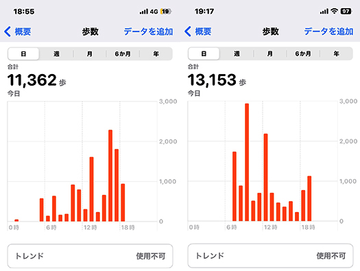
ふだんの札幌での散歩歩数は、だいたい7-8000歩程度に抑えているのですが、さすがに刺激の多い東京では連日1万歩越えが続いております。このなかでさらに食事についても、なるべく食事改善型のメニュー構成をアタマのなかで企画構成しております。やむなく外食ということになるので、その時間帯で選択可能な中で、注意深く選別するようにしている。
ということで、足の筋肉は各所からやや悲鳴っぽい叫び声。ホテルでの休息時にはストレッチで肉体疲労の沈静化に取り組んでいます。さて本日はふたたび東京ビッグサイトへ(笑)。頑張りたいと思います。ではでは。

English version⬇

Tokyo is a sacred place for walkers?
The number of steps I take every day exceeds 10,000. It’s an environment where curiosity comfortably stimulates my body, such as public transportation transfers and scurrying activities at event venues. …

This business trip is mainly a round trip between the hotel and Tokyo Big Sight. The main purpose of this trip was to visit the AI/artificial intelligence EXPO, where our partner company is presenting a case study of AI utilization, which we are also working on as a new business, and to experience the mega trend of the future direction of AI, I am not sure what to think about the current trends. The first day’s lectures had a huge number of participants, so much so that we had to separate the area for exit. The first day’s lecture was so well attended that we had to divide the audience into several areas to leave the venue. Japan seems to be good at dealing with this kind of “black ship” type shock, but we’ll see.
But the other big aim was the walking exercise (laughs).
When I go on business trips to Tokyo, I am forced to walk a lot anyway. When I am in Sapporo, I am basically working at my desk, so I have to intentionally take a purposeful early morning walk. In general, business travel and off hours are almost exclusively by car. In contrast, Tokyo has a well-developed public transportation system, so it is possible to complete almost all of your travel by getting on and off that system. However, access to that means is almost always walking.
And during that transportation, a great deal of real information pops into one’s eyes countless times. With a certain sense of déjà vu, information like, “Hey, this is happening,” keeps coming from over there. By being in contact with this flood of information for a short time in a concentrated manner, my innate temperament and curiosity are deepened and deepened (laughs).
And with it comes the compulsive walking exercise, like a Glico omake. My wife keeps ordering me to play Nintendo games to get exercise, but it is a much more natural human activity.
In Sapporo, I usually keep the number of steps to about 7-8,000, but in Tokyo, where there is a lot of stimulation, I am walking more than 10,000 steps every day. In addition, I am planning and composing a menu that improves my diet as much as possible. Since I have no choice but to eat out, I try to select carefully among the options available at that time of the day.
So, the muscles in my legs are screaming somewhat screamingly from all parts of my body. I am working on calming down the physical fatigue by stretching when I rest at the hotel. Well, today I am going to Tokyo Big Sight again (laughs). I will do my best. Good bye.

【ブラタモリ希望!人新世痕跡もある?積丹半島地形】


きのうから東京に出張。「AIエキスポ」を体感しておりました。が、情報を整理しておく必要性があるので、本日の追加体験も含めて札幌帰還後、まとめたいと思います。
なので本日のブログ記事は最近の流れに即して積丹半島地形篇であります。
ながく北の海の難所として「女人禁制」とまでされていた半島海岸線。わたしは普段は積丹の東側、石狩湾側をよく通行していますが、神威岬を超えた半島東側の地形観察しながら、いまさらながらその怪異ぶりに驚かされておりました。
わたしはテレビ革命世代の人間ですが、少なくともリアルタイム視聴するという習慣はほぼ消滅しています。テレビは「番組編成」ということでそれぞれの放送局が視聴者に予定スケジュールを強制してリアルタイムでの視聴を強いる存在。どうもこういう個人の権利への自己本位の独占的介入はもう時代遅れだと思います。そうではなくこれからの時代は、個人の自由な時間消費、その権利に委ねられるべきだろうと固く信じています。テレビ番組一般に拒否反応を持っているのではなく、やはり好きな情報番組はある。なかでもタモリの地質観察眼部分を最大活用しているブラタモリは録画してみる好きな番組。
話が横道系ですが(笑)、勉強系で歴史に次いで好きだった地学を基礎にしている情報番組って非常に貴重な存在だと思います。
で、この積丹半島の自然地形。1枚目は海岸線に接岸している部位の様子。みごとに異様な岩盤の節理ぶりに驚かされる。2枚目の山頂部の露頭ぶりも、なかなかのリアルな立体感。さらにトンネルの周囲には非常に奇妙な岩盤面が露出している。阿部比羅夫の時代から、海上からこういう光景を見させられてきた本土の人びとが、「蝦夷地・・・」という隔絶観を持ち続けてきた根拠のようにも思われます。
しかし3枚目の写真からはどう見ても自然的な造岩活動だけとは思われない。積丹半島をぐるっと回遊する道路建設は難工事に次ぐ難工事だったとされる。北海道の西側海岸線になかでも最高レベルの岩盤露頭が顕著にみられる。どうもこの写真からはトンネルを掘削したときに、岩盤層がきわめて崩れやすくてそれを安定させるのに、人工的補強材を注入したのではないか。一種の「人新世」痕跡であるのかも知れないと妄想(笑)させられていました。

English version⬇

[Bratamori Hope! Some traces of the Anthropocene? Shakotan Peninsula Topography
Complex traces of stratigraphic and orogenic activities of the earth. Tamori’s keen eye will help you dissect the traces that may have originated in the Anthropocene! Shakotan Peninsula

I started my business trip to Tokyo yesterday. I had a chance to experience the “AI Expo. However, I need to organize the information, so I would like to summarize it after my return to Sapporo, including today’s additional experience.
So, today’s blog post is about the Shakotan Peninsula topography in line with the recent trend.
The Shakotan Peninsula coastline has long been a difficult part of the northern seas, and was even considered a “no women allowed” area. I usually travel along the eastern side of Shakotan, the Ishikari Bay side, but I was surprised to see the bizarre topography of the eastern side of the peninsula beyond Cape Kamui.
I am a member of the TV revolution generation, but at least the habit of watching TV in real time has almost disappeared. Television is a form of “programming” in which each broadcaster forces its viewers to watch in real time by forcing them to follow a schedule. Apparently, this kind of self-centered, monopolistic intervention in individual rights is already outdated. Instead, I firmly believe that the future should be left to the free consumption of time and the rights of the individual. It is not that I have a rejection of TV programs in general, but I still like some information programs. Among them, Bratamori, which makes maximum use of the geological observation eye part of Tamori, is my favorite program to record.
I know this is a bit of a side-track (laughs), but I think it is very valuable to have an information program based on geology, which is second only to history in my favorite field of study.
The first picture shows the natural topography of the Shakotan Peninsula. The outcrops at the top of the mountain in the second picture are also quite realistic and three-dimensional. The outcropping at the top of the mountain in the second photo also has a very realistic three-dimensional appearance. This seems to be the basis for the segregated view of “Ezo…” held by people on the mainland who have been forced to see this kind of scene from the sea since Abe Hirao’s time.
However, from the third photo, it does not appear to be only natural rock-forming activity. It is said that the construction of the road that circles the Shakotan Peninsula was one difficult task after another. The highest level of rock outcrops can be seen on the western coastline of Hokkaido. The photographs suggest that when the tunnel was excavated, the bedrock layer was extremely fragile and artificial reinforcement was injected to stabilize it. I was made to fantasize (laugh) that it might be a kind of “Anthropocene” trace.

【船の交通超難所! 積丹半島の海岸線地形】


日本の交通の歴史では基本的には日本海海上交通が主役だったとされている。阿部比羅夫の北方遠征が200艘という大船団で北海道まで遠征可能だったことは、659年当時、それだけの海上交通の技術が発展していたことを表している。その直後の白村江海戦への日本艦隊の出撃もそのことを表している。
阿部比羅夫は白村江敗戦のあと、太宰府の長官職について来襲が予測された唐と新羅の連合艦隊に対して国防長官的な任務に就いていた。そのことはかれとその勢力が当時の海上交通の最先端技術集団だったことを知らしめていると思う。
積丹半島手前までの地域との間では日本の海上交通ネットワークは機能したのだろうけれど、しかし、その後の歴史ではながく積丹半島以北地域、札幌などの石狩湾地域は歴史痕跡が発現しない。先日触れたように、積丹半島の先端、神威岬以北は「女人禁制」とされたことで日本社会とは隔絶された化外の地として無視され続けることになった。
日本のヤマト政権が白村江などの朝鮮半島との緊張拡大方向に進まず、阿部比羅夫北方遠征の方向で主たる進出方向を北方に向けていれば、日本史はまったく違う展開を見せていたのかも知れない。上の写真は積丹半島の荒ぶる海と海岸線の様子。こういう難所に対して当時の兵員大量輸送の船の想像図を対置してみた。これは当時のWiki画像で見たヨーロッパの木造船イラストだけれど、想像では日本の阿部比羅夫船団も似たような様相だったと思える。
こういう船を作り,運航して日本海海域を移動進軍できていたのだから、その技術をさらに進化発展させればいかに難所とは言え、積丹半島を超えて石狩湾地域を開発することは十分に可能だったのではないか。明治以降、札幌を北海道の首府と定めて開発に着手してから150年の現在をみれば、地域のポテンシャルを生かし切れなかったこの間の歴史経緯が残念。「北のウォール街」とまで称された小樽の発展などの事例を見れば、659年から以降の平安期などで相当の発展は見込めたのではないか。
まぁその果実は奥州藤原政権が獲得して、独自の政権維持の大きな要素にしたということなのだろう。ただ、奥州藤原氏はむしろ、苫小牧周辺から日高方面に強い志向性を持っていたようだ。アイヌ社会との交易痕跡がこれらの地域に散見されることになる。
・・・さて本日から東京ビッグサイトでの「AI人工知能EXPO」に出張。ちょうど新事業でAIを活用していることもあってその協力企業のブースなどで最新情報に触れたいと思っています。

English version

Shakotan Peninsula: A super difficult place for boat traffic! Shakotan Peninsula Coastline Topography
Since the Japanese center symbolized by Abe Hirao came as far as the Goshi area, could the Sapporo area have participated in Japanese history from the Heian period if shipbuilding operation technology had been developed a little? …

In the history of Japanese transportation, the Sea of Japan maritime transportation basically played the leading role. The fact that Abe Hirao’s northern expedition was able to travel as far as Hokkaido with a fleet of 200 ships indicates that the technology of maritime transportation had developed to that extent in 659. The Japanese fleet’s expedition to the Battle of Hakuchon River immediately after the Battle of Hakuchon also indicates this.
After the defeat at the Hakuchon River, Abe Hirao was appointed as the chief of Dazaifu, and was assigned as the secretary of defense against the combined fleet of Tang and Silla, which was expected to attack Japan. This shows that he and his forces were the most advanced technological group in maritime transportation at that time.
Although Japan’s maritime transportation network may have functioned in the area up to the Shakotan Peninsula, for a long time afterwards, no traces of the history of the area north of the Shakotan Peninsula and the Ishikari Bay area, including Sapporo, appeared. As mentioned earlier, the area north of Cape Kamui, at the tip of the Shakotan Peninsula, was considered a “no women’s area” and was ignored by Japanese society as an outcast area.
If the Japanese Yamato regime had turned its main direction of expansion toward the north in the direction of the Abe-Hirau Northern Expedition, instead of moving in the direction of increased tensions with the Korean Peninsula, such as the Hakumura River, Japanese history might have developed in a completely different way. The photo above shows the rough sea and coastline of the Shakotan Peninsula. I have juxtaposed an imaginary image of a ship transporting a large number of soldiers at that time against such a difficult place. This is an illustration of a European wooden ship from a Wiki image of the time, but I imagine that the Japanese Abe-Hirau fleet was similar in appearance.
Since they were able to build and operate such ships to move and march in the Sea of Japan, it would have been possible to develop the Ishikari Bay area beyond the Shakotan Peninsula, no matter how difficult it was, by further advancing and developing their technology. Looking at the present 150 years since the Meiji era, when Sapporo was designated as the capital of Hokkaido and development began, it is regrettable that the potential of the region has not been fully utilized. Looking at examples such as the development of Otaru, which was even called the “Wall Street of the North,” we can see that considerable development could have been expected during the Heian period from 659 to the present.
Well, the Oshu Fujiwara government acquired the fruits of this development and made it a major factor in maintaining its own government. However, it seems that the Oshu Fujiwara were rather strongly oriented toward the Hidaka area from the Tomakomai vicinity. Traces of trade with the Ainu community can be found in these areas.
Now, I am going to Tokyo Big Sight for the “AI Artificial Intelligence EXPO” starting today. As I am using AI in my new business, I would like to get acquainted with the latest information at the booths of cooperating companies.

【高架道路から橋脚参道&鳥居 ニセコ「曽我神社」】


世界的な高級スキーリゾート地域として発展するニセコ地区。基本的には羊蹄山麓の農業地域ということで移動交通はクルマ利用。で、あちこちと移動していて尻別川にそそぐ支流がもたらす渓谷地形に高架道が設けられていて、そこを通りかかったら、脇に「参道」と鳥居が見えた。
「え、こんなところに?高架道から神社詣りなの?」というナゾの風景。で、地図をチェックしたら「そがじんじゃ」という神社があるとカミさんの報告。「え、蘇我神社?」って理解してしまった。蘇我神社は千葉県にある神社で、後方羊蹄とか、阿倍比羅夫とかの動乱の時代に日本史を彩る蘇我氏の末裔痕跡。
その蘇我神社があるのならば、符合すると考えられるということ急遽Uターンして参道を拝観し、本殿も参拝させてもらうことにしました。「もし蘇我神社ならば、後方羊蹄という日本書紀記述との歴史時代背景がシンクロしはじめるのではないか,ワクワク」

なんですが、よく神社名を確認したらヨミは「そがじんじゃ」だけれど、蘇我ではなく曽我という地名の神社と言うことがわかった。この一帯ではパワースポットとして知られている。調べてみたけれど、由緒はあんまり確定できない。明治以降に入植して成功した「曽我」という人物が建立したようです。1901年(明治34年) 曽我子爵がこの地の開拓を始める。1904年(明治37年) 創建。ということで周辺一帯に「曽我」という地名。
祭神 天照皇大神 八幡大神
1901年(明治34年)曾我子爵が開拓した曽我地域
1958年(昭和33年)神社創建。
で、どうしてパワースポットになっているのかは不明。たぶん橋の上を渡っていく非日常感が話題になっているのでしょうか。つい最近の創建と言うことなので、場所柄からのイメージと思われます。
しかし、日本というのは全国に八百万のように神社仏閣が存在し人びとがそうしたものに畏敬する文化を持っている。そういう社会性がひとびとの心性にいつしか染み込んで行っている部分がある。欧米のように一神教社会ではないけれど、それでもおだやかな社会的調和性が特徴になる社会。また歴史のヒントが無数にタイムカプセル化しているとも言える。この神社のように、高々つい最近、昭和時代の創建なのに大事にする社会。ホッコリとしたこういう文化は大切だと思う。

English version⬇

[Elevated road to bridge approach & torii, Niseko “Soga Shrine”].
I was excited to visit this shrine, mistaking it for the Soga Shrine, but unfortunately, it was not. I was excited to visit the shrine, mistaking it for Soga Shrine, but was disappointed (laugh). I was so excited to visit the shrine, but I was disappointed.

The Niseko area has developed into a world-class luxury ski resort area. Basically, it is an agricultural area at the foot of Mt. Yotei, so transportation is by car. As I passed by an elevated road in a valley formed by a tributary of the Shiribetsu River, I saw an “approach road” and a torii gate on the side.
What? Are you going to pay a visit to a shrine from an elevated road? It was a riddle scenery. I checked the map and found a shrine called “Soga Shrine,” my wife reported. I understood. I understood. Soga Shrine is located in Chiba Prefecture and is a trace of the descendants of the Soga clan that colored Japanese history during the period of upheavals such as the backward Yotei and the Abenohirau.
I made a hasty U-turn to visit the approach to the shrine and the main shrine. If it is the Soga Shrine, the historical background of the backward Yotei in the Nihonshoki Chronicles will begin to synchronize, which is very exciting.

However, when I carefully checked the name of the shrine, I found that it is not Soga but a shrine in the name of a place called Soga, although the yomi is “Soga-jinja”. It is known as a power spot in this area. I looked up the name of the shrine, but its history is not very definite. It seems that the shrine was built by a successful settler named “Soga” after the Meiji era (1868-1912), Viscount Soga started to settle the area in 1901 (Meiji 34), and the shrine was built in 1904 (Meiji 37). The whole surrounding area is therefore named “Soga”.
Gods of worship Amaterasu-O-no-Mikoto Hachiman-O-no-Mikoto
1901 (Meiji 34) Soga area developed by Viscount Soga.
The shrine was founded in 1958.
So, why it is a power spot is unknown. Perhaps the unusual feeling of crossing over a bridge is the topic of conversation? Since the shrine was founded only recently, it is thought to be an image from the location.
However, in Japan, there are as many as 8 million Shinto shrines and Buddhist temples throughout the country, and people have a culture of reverence for such things. This social nature has somehow become ingrained in people’s mentality. Although it is not a monotheistic society like in the West, it is still characterized by a gentle social harmony. It can also be said that there are countless time capsules of hints of history. Like this shrine, it was built only recently, in the Showa period, and yet it is still cherished by the society. I think it is important to have a culture like this, where people can feel relaxed.

【日本海航路の難所・女人禁制「神威岬」と北海道開発】


 縄文の約3,000年前とされる羊蹄山麓の環状列石遺構の見学から触発されての古代日本と北海道島の歴史探訪。基本交通路は船舶による交通手段の時代。阿倍比羅夫は、諸説はあるけれど北海道島に「後方羊蹄」という地名痕跡を確実に残している。
 北海道人としては、しかしその後、江戸期まで日本史との関わりの痕跡が途絶えることが不可思議。いくつかの伝承や文献記録などから、推理するくらいしか手掛かりに乏しい。
 伝承としては「義経伝説」があって、写真の積丹・神威岬を限界としてこの地以北が「女人禁制」とされたことが記録されている。義経が頼朝からの追捕の手を逃れて蝦夷地に逃避行したという「伝説」。最後は大陸に逃れて、その後ジンギスカンになったという荒唐無稽の伝承。その一節に、この神威岬にまつわるアイヌの族長の娘との悲恋物語。義経と恋仲になった娘は、追っ手から逃れるためにこの神威岬から出発した義経を追って、荒波にさらわれて命を落としたとされる物語。
 ながく北海道島が日本史の表面から姿を消している時期。平家物語の語り部として全国の村々の祭りなどの機会に琵琶の伴奏つきの物語を語った法師たちから、その内容を受け取ったその時代の大衆が、判官びいきという心象を持ったことは蓋然性が高い。そういう心理が多様な義経伝承を生んだものだろうか。
 ニセコ地域からの帰り道、積丹半島をぐるっと回って帰ることにした。

 神威岬は1−2回は来ているけれど、今回はまことに「風極」とでも言える強風。日高の襟裳岬でも体験したけれど、大人でも立っていられないくらいで、子どもたちはふざけていると実際に風に飛ばされて転んだりしていた。岩礁地帯で岬自体、半島自体が巨大な造岩活動の凄まじさを表現する地形と、この風の強烈さで江戸期くらいまで開発が遅れたのかという体感を持った(笑)。
 実際に「女人禁制」としたのは、江戸期の松前藩による海産資源・経済利権の秘密保持が目的だったのだろうけれど、このことが北海道開拓進展に桎梏となったことも事実。神威岬から先の石狩湾以北に行くには舟しかなかったので岬を通行禁止にされると女性は石狩以北には行けなかったのだ。女人禁制とは、それ以北に「定住するな」「出稼ぎしか認めない」という宣言であり、地域開発するという意思はどこにも見えず、ただただ、自藩の交易利得にしか価値感を持っていない地域政権。事実上の松前藩による「開拓禁止」政策だった。
 今日の北海道と江戸期の松前藩にはどのようにも「継承性」がない。たぶん全国の大名領地と明治以降の関係性の中で、北海道ほど断絶が際だっている地域もないだろう。「直轄支配」時期のこともあり、むしろ江戸幕府の方が開明的に北方防衛意識を高く持って北海道島の未来と向き合っていた。松前藩が南方の薩摩のような藩であったら、その後の日本史は大きく変化した可能性がある。

English version⬇

Cape Kamui, a difficult point on the Japan Sea route and forbidden to women, and the development of Hokkaido
The Matsumae Clan of the Edo period delayed the development of the Shakotan Peninsula north of Cape Kamui by taking advantage of a legend about Yoshitsune. A clan that clung to its marine products trading interests and had no regional development policy. The Matsumae Clan

A historical exploration of ancient Japan and the island of Hokkaido, inspired by a visit to the ringed stone remains at the foot of Mt. Yotei, which are believed to date back about 3,000 years to the Jomon period. The basic transportation route was by ship in those days. Abenohirau definitely left traces of the place name “backward Yotei” on the island of Hokkaido, although there are various theories.
As a Hokkaido native, however, I find it strange that traces of the area’s connection to Japanese history ceased after that, until the Edo period. There are only a few clues that can be deduced from folklore and written records.
There is a “Yoshitsune legend” that records that the area north of Cape Kamui, pictured in the photo, was forbidden to women. The “legend” tells of Yoshitsune’s escape to Ezo, escaping from Yoritomo’s pursuit. The wild folklore says that he finally escaped to the continent and subsequently became Genghis Khan. In this passage, there is a tragic love story about the daughter of an Ainu chief who was in love with Yoshitsune. It is said that the daughter, who fell in love with Yoshitsune, was snatched away by a stormy sea and lost her life in pursuit of him as he departed from Cape Kamui to escape his pursuers.
It is highly probable that, at a time when the island of Hokkaido had long disappeared from the surface of Japanese history, the public of that era, who received the content of the tale, had a mental image of a favoritism toward the priests who told the story with biwa accompaniment at festivals and other occasions in villages across the country as storytellers of the Heike tale. Such a mentality may have given birth to the diverse folklore of Yoshitsune.
On the way back from the Niseko area, I decided to go around the Shakotan Peninsula.

I have been to Cape Kamui once or twice, but this time the wind was so strong that it could be described as a “wind pole. Even adults could not stand up, as we experienced at Cape Erimo in Hidaka, and children were actually blown away by the wind and fell down when they were joking around. The cape itself is a rocky reef area, and the cape itself and the peninsula itself have a topography that expresses the tremendous rock-making activity, and I had the feeling that the development of the area was delayed until around the Edo period because of the intensity of this wind (laugh).
The reason for the “no women allowed” policy may have been to maintain the secrecy of the Matsumae clan’s marine resources and economic interests during the Edo period, but it is also a fact that this policy was a deterrent to the development of Hokkaido.
The prohibition of women was a declaration that “no settlement” or “only migrant workers” would be allowed north of the boundaries of Hokkaido, and the regional administration had no intention of regional development, but only a sense of value for its own trading interests.
There is no “inheritability” in any way between today’s Hokkaido and the Matsumae clan of the Edo period. Perhaps no other region in Japan has such a remarkable disconnect between the feudal lords’ domains and their relationship with each other since the Meiji era as Hokkaido. Because of the period of “direct rule,” the Edo shogunate faced the future of the island of Hokkaido with a high awareness of northern defense in a rather open-minded manner. If the Matsumae clan had been like Satsuma in the south, the subsequent history of Japan could have been very different.

【1364年前と現代 大和王権・世界との遭遇 in羊蹄山麓】


連休中に訪れていたニセコ地域で縄文期遺跡など思わぬ歴史事実との遭遇。歴史好きの本性は、最近すっかり本州地区行脚に費やされていましたが、今回で北海道地元にスポットが当たってしまった。北海道人としては、後世のひとたちにこういった歴史情報を解明しておく責任の一端はあるかもしれない。もちろん専門研究者の情報に基づいて、広く興味を拡散して世論を醸成するという意味合い。
この羊蹄山周辺地域はいまや世界的な雪質レベルでのリゾート開発が盛ん。世界的なスキーリゾートとして欧米からの来訪者で大いに賑わっている。図のように「NISEKO UNITED」ということでシルキースノーゾーンが広がっている。日本人ではスキー人口はそれほど伸びているとは聞かないけれど、シーズンになると英語などの方が当地では優勢になるそうです。わたし自身はスキー学校授業程度ほぼ興味がない。そういうことなので来るのはもっぱら夏場ということになるけれど・・・。
どうもこの地にはそういう「外からの注目」が集まりやすいのかも知れない。今回歴史好きとしてふとした気付きから日本・ヤマト王権が北方国防対策として、この地域に軍団遠征を200艘もの大船団で行った事実は大変なインパクト。659年当時はオホーツク人という北方からの「外圧」への対応だったのだろうが、ある意味では土地が持つ「気」のようなものが外部から人を呼び寄せるのかも知れない(笑)。
写真のように北海道の建築関係者にとって当地のリゾート開発建築の最初期は素性の定かでないオーストラリアの不動産業者による進出で、信用状況でもやや不安を持たざるを得ない取引だったという。サンモリッツなどの欧米のハイエンドリゾート需要、そうした活発な投資活動は北海道全体にとって有意義。現在では多くの貸別荘群がゲレンデ周辺の好適地で新築されてきている。ヒルトンなどの欧米資本の進出もある。

さて歴史好きの阿倍比羅夫遠征での「後方羊蹄」についての調査活動。その当時の朝鮮・白村江海戦での日本側遠征船団と人員規模について、好きな歴史作家・安部龍太郎氏の論考では1艘あたり30人の兵員輸送だったとされるので、200艘船団では5,000-6,000人規模の大遠征軍団。
逆に言えばこうした大船団が編成されたので北から西に方向転換して白村江海戦に突入してしまった、とも言えるのだろうか。この軍勢が河口に上陸し、兵糧などの運搬に適した尻別川が通っている「比羅夫」という地名が残る羊蹄山麓まで、GoogleMapでの陸上歩行時間距離では8時間ほどとなっている。
この距離感であれば1−2日の行程で武装しての進軍も可能だったことだろう。
羊蹄山麓地域まで阿倍比羅夫を護送するのには50-60人程度の軍勢で十分か。環境要因を見てみればたしかに軍事移動は十分可能だっただろう。政庁の設置も可能だと思えるが、さて。

Enlish version⬇

1364 Years Ago and Today: Encounters with Yamato Royalty and the World in Yotei Foothills
Is this the local environment that attracts the most “outside attention” in Hokkaido now and in the past? World-class ski resorts and the Abenohirou expedition. …

While visiting the Niseko area during the holidays, I came across some unexpected historical facts, including Jomon-period ruins. My love of history has recently been completely consumed by my travels in the Honshu area, but this time I found myself in the Hokkaido area. As a Hokkaido native, I may have a part of responsibility to clarify this kind of historical information for future generations. Of course, this is based on information from professional researchers, but it is also meant to spread interest and foster public opinion.
The area surrounding Mt. Yotei is now being actively developed as a resort with world-class snow quality levels. As a world-class ski resort, it is very crowded with visitors from Europe and the United States. As shown in the figure, a silky snow zone called “NISEKO UNITED” is spreading. Although I don’t hear that the ski population is growing that much among Japanese, I hear that English and other languages are predominant in this area during the season. I myself am not interested in ski school classes. So I come here only in the summer.
I guess it is easy to attract such “attention from outside” to this place. As a history buff, I suddenly realized that the fact that the Yamato Kingdom of Japan conducted a military expedition with a fleet of 200 ships to this area as a measure to defend the northern part of the country had a great impact on me. In a sense, the “spirit” of the land may have attracted people from the outside (laughs).
As you can see in the photo, for architects in Hokkaido, the initial resort development construction in the area was done by an Australian real estate developer of unknown background, and they had to be a little apprehensive about the credit situation. The demand for high-end resorts in Europe and the U.S., such as St. Moritz, and such active investment activities are meaningful for Hokkaido as a whole. Many new rental villa complexes are now being built in prime locations near the slopes. There is also the entry of European and U.S. capital such as Hilton.

Now, research activities about “Rear Yotei” in the Abenohirao expedition of history buffs. According to my favorite history writer, Ryutaro Abe, the Japanese expeditionary fleet and its personnel size at that time at the Battle of Paekchon River in Joseon was said to have transported 30 soldiers per ship, so a fleet of 200 ships was a large expeditionary force of 5,000 to 6,000 soldiers.
Conversely, it could be said that such a large fleet was organized, so it changed direction from north to west and plunged into the Battle of Hakuchon River. According to Google Map, it takes about 8 hours to reach the foot of Mt. Yotei, where the Shiribetsu River, which is suitable for transporting food and supplies, runs through.
This distance would have made it possible to march armed to the teeth in one or two days.
A force of about 50-60 men would have been sufficient to escort Abephirao to the foot of Mt. Looking at the environmental factors, it would certainly have been possible to move the military. It would also be possible to set up a government office.

【阿倍比羅夫と対話した縄文の末裔の人びと】


日本書紀の記述、斉明天皇の条での阿倍比羅夫の北征。古代世界で突然のように北辺の世界の記述が出てくることから、多くの研究が日本各地で行われてきている。北海道に暮らすものとして、何度もこのナゾに問いかけてきている。今回も現地周辺を行脚しながら想像力を巡らせてきていた。わたしとしては流域面積で北海道での6番目の「大河」である尻別川流路から、羊蹄山をつねに目標としながら上っていく山麓地域のどこかが比定されるのではないかと考えている。事実として「比羅夫」という地名も残されている。地名にはタイムマシンのように伝承などの故実が表現されていると考えるのが自然だと思うのです。
この日本書紀記述を巡っては倶知安町や余市町などで、後方羊蹄(しりべし)の政庁「郡領」はわが町存在したに違いないと論争が繰り返されてきた。いまのところ郷土の歴史の一断面として今後の調査に期待するところ。
一方で阿倍比羅夫が接触した人びとについて、いろいろな解析が進んできている。7世紀頃の北海道ではアイヌ文化はまだ成立せず、それ以前の「擦文」の人びとが文化圏を築いていた。以下の図表は、JT生命史研究館「縄文人の核ゲノムから歴史を読み解く〜国立科学博物館・神澤秀明」からの参照。https://www.brh.co.jp/publication/journal/087/research/1


この解析から想起できることは本土の人びとはより現在のDNAに近く、北海道島の人びとはより縄文人に近しい存在だったと。この分析からは、この時期に阿倍比羅夫と遭遇し「郡領」設置を進言したという人びとは、より縄文人の血が強い人びとだったことが想像できる。
北海道で活躍する考古学の瀬川拓郎氏の説によれば、この時期、アムール川河口周辺発祥の北方アジア系の「オホーツク文化人」の人びとが大型海獣の狩猟を中心としたライフスタイルで北海道のオホーツク沿岸地域に進出しており、かれらは交易を通じて日本社会との接点拡大を目指して日本海側にも進出していた。
そのことからこの後方羊蹄地域の縄文由来の擦文の人びとと緊張状態に陥り、そした背景から交易相手であるヤマト王権社会に「援軍」を請うた結果が阿倍比羅夫の遠征だったのではないかとされている。
奥尻島と想定される戦場で、実際に戦闘が行われ、阿倍比羅夫に従軍した副官クラスが奥尻島で戦死したとされている。
こういった北海道島の日本史との接触記録が、しかしその後、鎌倉期くらいまで眠ったようになる。遠征した阿倍比羅夫の血統は奥州安倍氏に連なるという説もある。その経済基盤としての対北方世界「交易」の実態は奥州藤原氏の奇跡的な栄華としても明らか。
日本の北方史は多くの魅力的なミッシングリンクに満ちている。

English version⬇

[People of the Jomon descendants who conversed with Abepirāu.
From Abephirao’s expedition onward, until the Kamakura period, there was a missing link in the world of the rise and fall of the Oshu Fujiwara clan, which is poorly documented. However, there were historical facts in Hokkaido. …

The description of the Nihonshoki, the northern conquest of Abenohirau in the article of Emperor Saimei. Because of the sudden appearance of descriptions of the northern world in the ancient world, a great deal of research has been conducted in various parts of Japan. As a resident of Hokkaido, I have repeatedly asked this riddle. This time, too, I have been exploring my imagination as I traveled around the area. I believe that the Shiribetsu River, the sixth largest river in Hokkaido in terms of watershed area, is located somewhere in the foothills of the mountain range, always with Mt. In fact, the place name “Hirao” has been preserved. I think it is natural to think that place names are like a time machine, expressing folklore and other historical facts.
There have been repeated disputes in Kutchan Town, Yoichi Town, and other towns over this Nihon Shoki description, arguing that there must have been a “county seat” of government in Shiribeshi in the backward direction in our town. At present, this is just one aspect of our local history, and we look forward to further research in the future.
On the other hand, various analyses of the people with whom Abenohirau came into contact are underway: the Ainu culture had not yet been established in Hokkaido around the 7th century, and the “Scrubun” people had established a cultural sphere before that time. The following figures and tables are from “Reading History from the Nuclear Genome of the Jomon People: Hideaki Kanzawa, National Museum of Nature and Science,” JT Biohistory Research Hall.

This analysis suggests that the people of the mainland were closer to the present DNA, while the people of Hokkaido Island were closer to the Jomon people. From this analysis, we can imagine that the people who encountered Abenohirau and advised him to establish a “county fiefdom” during this period were people with stronger Jomon blood.
According to the theory of Segawa Takuro, an archaeologist active in Hokkaido, during this period, “Okhotsk Culture people” of northern Asian descent who originated around the mouth of the Amur River expanded into the Okhotsk coastal region of Hokkaido with a lifestyle centered on hunting large marine animals, and they also expanded into the Sea of Japan side, aiming to expand their contacts with Japanese society through trade. They also expanded to the Sea of Japan side in order to expand their contacts with Japanese society through trade.
This may have led to tensions with the Jomon-derived Abrahamic people of the Yotei region, and the Abenohirau expedition may have been the result of their request for “reinforcements” from their trading partners in the Yamato Royal Society.
It is said that a battle actually took place on the supposed Okushiri Island battlefield, and that the second-in-command who served with Abepirāyu was killed on Okushiri Island.
These records of contact with Japanese history on the island of Hokkaido, however, then seem to have fallen asleep until about the Kamakura period. Some believe that the lineage of the Abenohirou expedition is linked to the Oshu Abe clan. The reality of “trade” with the northern world as its economic base is also evident in the miraculous prosperity of the Oshu Fujiwara clan.
Japan’s northern history is filled with many fascinating missing links.

【阿倍比羅夫の北方遠征と「後方羊蹄」尻別川】


わたしは旅先とか、出張などで訪れる地域の「地史」への興味が非常に盛り上がるタイプなのか。歴史書は好きですがもちろん網羅的に読破しているわけではない。実際に訪問するとその周辺記憶領域が強く反応して「おい、おまえ、この辺のこと放置しているべや」とうごめき、ささやき返してくる。
今回ニセコ地域を遊動してみて、あらためて日本史との関係性に強く思いが至ってしまった。やはりこの地域と日本史の関係では阿倍比羅夫の北方遠征が強烈な古代史のインパクト。地名にまで比羅夫がある。
阿倍比羅夫は高志(越)国・越後の国司の地位にあって大化の改新時期の有力人物。この北方制圧の政治軍事行動からその後、翌年には古代日本の大敗戦である白村江へも出征している。当時の日本国家の「海軍力」は環日本海が主戦場。そこに特化して活動したことから、事実上の国家軍事部門統括だと推認可能。舟の大きさも不明だけれど180-200艘の軍団規模「大河のほとり」に進出したとされる。地元の族長たちはその勢威に圧倒されて恭順を申し出てきたのだという。この「大河」がさてどこであるのか、ということからして北海道地域史では確定的な論を持っていない。
阿倍比羅夫が置いたとされる「郡領」の位置を巡って多数の研究者たちが多年にわたって発掘などの調査活動を行ってきているとされている。国書に記載があるとは言え、そもそも事実としてそういった「建築的施設」があったのかどうかも不明なのだから、労多い作業だとは思う。
一介の歴史好きとしては研究者のみなさんの活動に期待しつつ、後方羊蹄という残された地域名と、大河という表記、そして大軍船団という歴史事実から推定して、写真のような光景が古代人にも同様に映じていたと考えられると思っている。
いまの河川名で言えば「尻別川」が擬定されるにふさわしい。阿倍比羅夫の遠征は、その後の白村江出征も国家的な海軍力の示威であり、実際の戦争行為でもあったことから、この北方遠征もそういったコンテキストと同様でしょう。この地域で族長層からは日本古代王権に対しての服従対応があったということ。
阿倍比羅夫は帰朝後、ヒグマの毛皮多数と,生きたヒグマ2頭を朝廷にもたらしたといわれる。この後方羊蹄地域の族長たちと「戦わずして外交的に勝利した」ということが真実なのだろう。郡領を設置したらと申し出たのは現地族長層からだったとされている。
さてそこで実際に阿倍比羅夫は羊蹄山の周辺地域まで「郡領」を設置しに向かったかどうか。現地族長たちにしてみると、たしかに大河の畔でその軍威にひれ伏したけれど、実際に自分たちのテリトリーまで軍の首領を導き入れるかどうかは疑問も残る。阿倍比羅夫としてもそこまで身の安全確保に自信を持てただろうか。興味津々の地域史探偵団であります(笑)。

English version⬇

Abenohirao’s Northern Expedition and the “Backward Yotei” Shiribetsu River
Yotei from the Shiribetsu River mouth area, and was offered submission by the local tribal leaders. Diplomatically, the expedition was a success. Whether or not they actually established “county fiefdom” building facilities? ・・・

Am I the type of person whose interest in the “local history” of an area I visit when traveling or on a business trip is very excited? I like history books, but of course I have not read them exhaustively. When I actually visit an area, my peripheral memory reacts strongly and whispers back to me, “Hey, you, you left this area out.
This time, as I traveled around the Niseko area, I was reminded of the strong relationship between the area and Japanese history. As one would expect, the relationship between this area and Japanese history is strongly influenced by the northern expedition of Abepirābu, which had a strong impact on the ancient history of Japan. Even the name of the place has Hirao in it.
Abenohirau was a powerful figure during the Taika Reform Period in his position as provincial governor of Koshi-no-Kuni and Echigo. From this politico-military action to control the northern part of the country, he later went to the Hakumura River, the great defeat of ancient Japan, in the following year. The main battlefield for the “naval power” of the Japanese nation at that time was the Japan Sea Rim. Since he specialized his activities there, it can be inferred that he was in charge of the de facto national military department. Although the size of their ships is unknown, it is said that they advanced to the “banks of the great river” with an army of 180 to 200 ships. The local chiefs were overwhelmed by the force of the army and offered their respect. The history of Hokkaido does not have a definite theory as to where this “great river” was located.
Many researchers have been excavating and investigating the location of the “county fiefdom” where Abenohirau is said to have placed it for many years. Although it is mentioned in the National Records of Japan, it is still unclear whether or not such an “architectural facility” existed in the first place, so it is a laborious task.
As a history buff, I look forward to the activities of researchers, but based on the name of the area, which remains as Yotei in the back, the description of the river, and the historical fact of a large military fleet, I believe that the ancient people would have seen the same scene as in the photo.
In today’s river names, the Shiribetsu River is an appropriate name for the area. The Abenohirao expedition would be similar to such a context, as the subsequent expedition to the Hakumura River was also a demonstration of national naval power and an actual act of war. It means that there was a submissive response to the ancient Japanese kingship from the chiefs in this region.
Abenohirau is said to have brought a large number of brown bear pelts and two live brown bears to the imperial court after his return. It is probably true that he “won a diplomatic victory without a fight” with the chiefs of this backward yotei region. It is said that it was the local chiefs who offered to establish a county fiefdom.
Now, whether or not Abepirābu actually went to the area around Yotei to establish a “county fiefdom” is not clear. The local chieftains were indeed prostrated by his military might on the banks of the great river, but it is doubtful that they would actually lead a military leader into their own territory. Would Abenohirau have been so confident of his own safety? The Local History Detective Corps is very curious (laughs).

【神々が坐す 素朴な自然崇拝の「後方羊蹄」地域】


きのうのニセコでの環状列石探訪での古代縄文人の痕跡に気付かされ、知らず知らずわたし自身も陥っていた北海道地域観、大自然がそのまま残っている未踏の開拓地的な史観がゆらぎを見せ始めています。人跡・文化性への極度の軽視から目を見開かされたような思いがある。
たしかに人跡の歴史には連続性は乏しいけれど、それなりに点景としては存在していることに改めて思いが至っていました。
日本史との接点ではこの羊蹄山周辺地域・ニセコは「後方羊蹄〜シリベシ」という地名地域として、阿倍比羅夫の遠征期に名を記している。この漢字の文字記述とよみがなとの乖離感はたぶん日本語の中でも特異な例でしょう。
さらに現代地名表現としての後志と書いてシリベシと読むのも、この表記・音読との関係性が出発点なのでしょう。他地域のみなさんは漢字表現とよみに強い違和感を覚えるだろうと思います。
阿倍比羅夫の北方遠征については以下の「『福井県史』通史編1原始・古代」記述がある。「比羅夫は水軍180~200艘を率いて北征したがそのための造船はもとより、兵員や食糧の調達は莫大だった。その負担に堪えたのはおそらく能登・加賀を含む広義の越前が主だったであろう。比羅夫の遠征軍は、斉明天皇四年(659年前後)に齶田・渟代(秋田・能代)を平定。渡嶋の「蝦夷」をも綏撫して帰還。この年にまた比羅夫は粛慎を討って帰還した。同五年には飽田・渟代二郡の「蝦夷」のほか、津軽郡・膽振「蝦夷」を饗応し進んで肉入篭に至り、後方羊蹄に郡領を置いて帰った。同六年にも、渡嶋の「蝦夷」を味方として幣賂辨島の粛慎と戦った。」
ここに記述された「後方羊蹄」という地域は常識的に考えれば写真のような現代の羊蹄山周辺地域。ここに「郡領を置いた」という記述からは、一定の人口社会地域であることが推定される。きのう見たような約3,000年前当時の縄文期の遺跡から、この1,364年前当時まで、少なくとも1,700年程度は一定の集落社会が形成され続けていたと考えることが自然なのではないか。こういう推論に基づいて丹念に考え続けることが必要なのかも知れません。
現代の北海道地理観でも、積丹半島の先端部・神威岬は猛烈な強風で知られ、そこを超えた石狩平野地域は江戸期くらいまで女人禁制とまでされていた通行困難地域。いまでも札幌から移動するには山岳地域を抜ける必要がある。いわゆる蝦夷ヶ島の交通可能エリアとしては、ニセコ地域は日本社会との接触可能圏だったと考えられる。そういう背景があって「郡領を置いた」のだろう。現代ではこの地域は海外との接触が非常に高まってもいる地域。歴史探偵団的にたいへん面白みがある。

English version⬇

A simple nature-worshipping “backward yotei” area where the gods sit.
The area where Abenohirau “established a county fief” during his northern expedition 1,364 years ago. 3,000 years ago, during the Jomon period, we can predict the continuous existence of a populated society. The area was “the county seat” during Abenohirau’s northern expedition 1,364 years ago.

Yesterday’s visit to Niseko and the traces of the ancient Jomon people were a reminder to me that my own view of Hokkaido as an unexplored frontier with its natural wonders intact is beginning to waver. I feel as if my eyes have been opened from the extreme disregard for human remains and culture.
It is true that there is little continuity in the history of human sites, but I have come to realize once again that they exist in their own way as a point of view.
In terms of contact with Japanese history, the area around Mt. Yotei, Niseko, was named “Yotei Shiribeshi” during Abenohirou’s expedition. This divergence between the Kanji character description and the yomigana is probably a unique example in the Japanese language.
Furthermore, the modern use of “Goshi” as a place name expression, reading “Shiribeshi,” is also probably based on this relationship between the written and phonetic readings. I believe that people from other regions may feel a strong sense of discomfort with the Chinese characters and pronunciation.
The following is a description of Abeno Hirao’s expedition to the north in the “History of Fukui Prefecture,” General History, Part 1, Primitive and Ancient Times. The burden of building ships and procuring men and food for the expedition was enormous. It is likely that the burden was borne mainly by Echizen in the broad sense of the word, including Noto and Kaga. Hirao’s expeditionary force pacified Jinden and Nugushiro (Akita and Noshiro) in the 4th year of the Emperor Saimei (around 659). He also returned after having pacified the “Emishi” of Watarajima. In the same year, Hirao also returned after defeating Sukune. In the same year, he served “Ezo” in Ajita, Nuyo, Tsugaru-gun, and Ezo in Echigo-Tsumari, and returned to Yotei with his county territory in the rear. In the same year, he fought against Sukune of Beshima with the “Emishi” of Watarajima as his allies.
The area described here as “back Yotei” is, to the casual observer, the area around modern Mt. The description of a “county fiefdom” here suggests that it was an area with a certain population. It is natural to assume that a certain settlement society had continued to be formed for at least 1,700 years from the Jomon period ruins we saw yesterday, about 3,000 years ago, to this time, 1,364 years ago. It may be necessary to continue to think painstakingly based on this kind of reasoning.
Even in the modern geographical view of Hokkaido, Cape Kamui, at the tip of the Shakotan Peninsula, is known for its ferociously strong winds, and the Ishikari Plain area beyond Cape Kamui was a difficult area where women were even forbidden to travel until around the Edo period. Even today, travelers from Sapporo must pass through mountainous areas. The Niseko area is thought to have been the only area in the so-called “Ezo-gashima” area that was accessible to Japanese society. It is against this background that the “county territory” was established. In the present day, this area is also a region where contact with the rest of the world has increased greatly. It is very interesting from the perspective of the Historical Detective Corps.

【古代天文科学・羊蹄山頂同緯度の縄文「曽我北栄環状列石」】


連休初日なので遠出しております。最近出掛けることが多いニセコ方面。カミさんが食事改善に伴って新鮮野菜探究にまっしぐらで、アスパラガスの旬の食感に強いこだわりを求め始めていまして、ニセコビュープラザ道の駅に出店される地元農家の朝市をたのしみに出掛けている次第。という動機について詳しく知ったのは実はきのうでして(笑)、わたしとしては「そんなんなら、地元の人にいつころから出荷するか,聞けばいいっしょ」ということなのですが、なにせコミュニケーション不足(笑)。
で、きのう確認したところこちらでの出荷の旬は今月中旬〜下旬とのことでまだシーズン前ということであります。でもまぁ、それは動機のひとつに過ぎない。遠出ドライブはキライではない。
ということで、その近隣であちこち巡っていたら、こちらの「曽我北栄環状列石」に遭遇。考古好きのわたしとしても強く惹かれた次第。情報では「羊蹄山山頂火口縁の北側と同緯度(北緯42度49分35秒)」なのだということなのです。先日の日本古代王権ゆかりの淡路伊弉諾神宮でも触れたのですが、その所在地の真東に大和藤原京や、伊勢神宮内宮が位置するという古代での「天文科学」の存在痕跡。
そのような天文科学に基づいた遺構が、北海道の羊蹄山周辺の高地平野部に存在するという事実を初めて知ったのであります。写真上はその遺構から真東方向に羊蹄山を見たところ。その下のGoogleMapは、正確な東西南北通りのマッピングなので、たしかに羊蹄山頂とこの遺構が、地球物理の解析結果の現代科学知識とレベルを共にして、同緯度に存在することが目視確認される。
昭和26年、東京大学教授・駒井和愛氏による発掘調査。第1号から第4号の4基の環状列石が残されており、発掘調査で人骨と思われる骨片、石錐、翡翠製の臼玉、深鉢型縄文後期式土器が発見され、研究者は祭祀的なものというより、環状列石墓であると主張されている。3000年ほど前、縄文人が居住地と墓を分離したときの墓であると。
ニセコ町では縄文時代の遺跡は発見されているが、中世(鎌倉、室町)から江戸後期に至るまでの記録(アイヌ時代)の遺跡が発見されておらず謎となっている。幕末の探検家・松浦武四郎は羊蹄山を『日本書紀』に記された後方羊蹄(しりべし)と推測している。
考古数寄としては、まことに好きな展開(笑)。たまたまカミさんの情報調査がきっかけで訪問出来たのですが、非常に刺激を受けています。灯台もと暗し、古代浪漫、淡路島と同レベルの事実が地元北海道でも、であります。ワクワク。

English version⬇

Ancient Astronomical Science, Jomon “Soga-Hokuei Ring Stones” at the same latitude as the summit of Mt.
Is this an ancient scientific example similar to the case of Awaji Izanagi Shrine and the Inner Shrine of Ise Jingu at the same latitude? An encounter with a fact that makes my archeological blood boil. …

It is the first day of a consecutive holiday, so we are going away. Recently, we have been going out to Niseko. My wife has been on a quest for fresh vegetables as she has been improving her diet, and she has started to pay close attention to the texture of asparagus in season. I learned more about their motivation yesterday (laugh), and I thought to myself, “If that’s the case, why don’t I just ask the locals when they start shipping their produce?
(Laughs) So, I checked yesterday, and the shipping season here is from the middle to the end of this month, which means it is still before the season. But, well, that is only one of the reasons. I am not averse to a long drive.
So, as I was cruising around the neighborhood, I came across the “Soga Hokuei Loop Stones” here. As an archeologist, I was strongly attracted to it. According to the information, it is located at the same latitude (42 degrees, 49 minutes and 35 seconds north latitude) as the northern side of the crater rim of the summit of Mt. As mentioned in the recent article on Awaji Izanagi Shrine, which is associated with ancient Japanese royalty, the Yamato Fujiwara Capital and the Inner Palace of Ise Jingu are located directly east of the site, which is a trace of the existence of “astronomical science” in ancient times.
This was the first time I learned of the existence of such astronomical remains in the highland plains around Mt. The upper photo is a view of Mt. Yotei looking directly east from the remains. The GoogleMap below is an accurate mapping of the north-south-east-west street, which confirms that the summit of Mt. Yotei and these remains are indeed at the same latitude and level of modern scientific knowledge of the geophysical analysis.
Excavation by Professor Kazuai Komai of the University of Tokyo in 1951. The excavation revealed bone fragments, a stone cone, a jade mortar ball, and a deep bowl-shaped Late Jomon-style earthenware, which researchers claim are annular tombs rather than ritual tombs, dating back about 3,000 years, when the Jomon people separated their graves from their settlements.
Although Jomon-era sites have been discovered in Niseko Town, the remains of records from the Middle Ages (Kamakura and Muromachi) to the late Edo period (the Ainu period) have not been found and remain a mystery. Takeshiro Matsuura, an explorer at the end of the Edo period, speculated that Mt. Yotei was the backward Yotei (Shiribeshi) mentioned in the Nihon Shoki (Chronicles of Japan).
As an archaeologist, I really like this development (laughs). I happened to be able to visit the site because of Kami’s information research, and I am very much inspired. It is a fact that the same level of darkness under the lighthouse, ancient romance, and Awaji Island can be found in my hometown, Hokkaido. I am excited.