本文へジャンプ

【香取の海から津宮に上陸・香取神宮① 東国三社探訪-15】


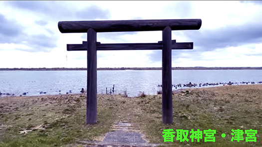
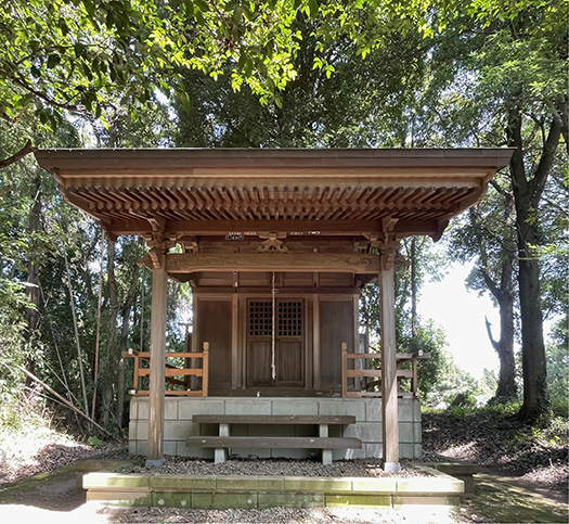
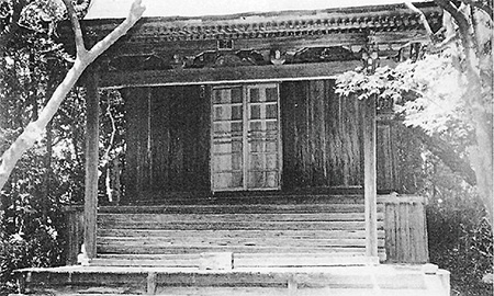
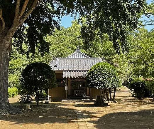
津宮というのは香取神宮「一の鳥居」と称されている。その場所は現在の「利根川」に面して建てられている。水辺から上陸して神さまが渡御されるという故実に即している。
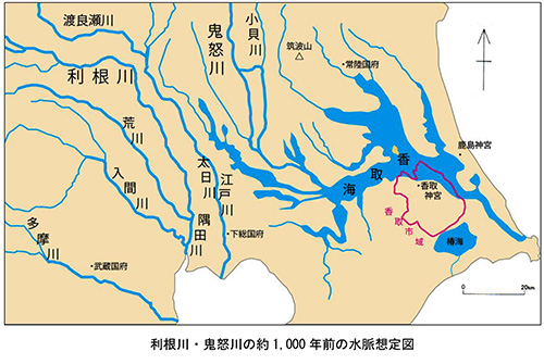
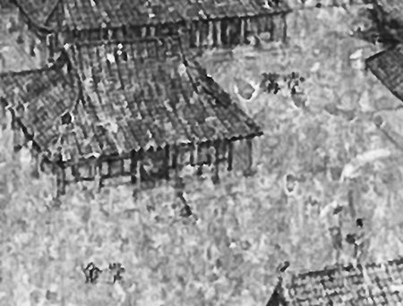
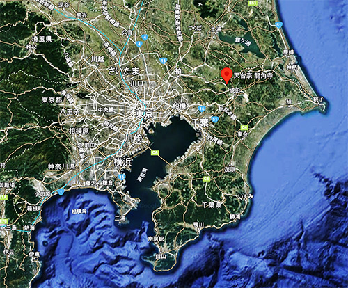
2番目の地図は先般来、このシリーズで紹介してきた古地図で、約1000年前の古地形を表現したもの。香取市がまとめている「第1章 香取市の歴史的風致形成の背景」PDF書類に掲載されている。
地元紙「千葉日報」記事では以下の記述もある。〜内陸部である現在の利根川流域には「香取海」という大きな内海が広がっていた。その範囲は現在の霞ケ浦・印旛沼・手賀沼の辺りが一つにつながった広さ。香取海は縄文時代から水上交通が盛んだった。飛鳥奈良期には香取海の千葉県側に印波国・下海上国(しもつうなかみのくに)茨城県側に筑波国・仲国・茨城国があり、沿岸には多くの古墳が造られた。香取海は朝廷が東国を支配する上で重要な役割があった。日本書紀や常陸国風土記にはヤマトタケル東征の際に香取海を渡ったと思われる記述がある。香取神宮(香取市)と鹿島神宮(鹿嶋市)の二社は香取海入口の対岸にあり、蝦夷の平定神として崇拝され、前社は下総国、後社は常陸国の一宮に位置付けられた。〜
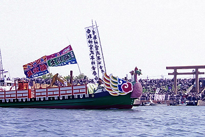
3番目の写真は鹿島神宮と同様に香取神宮でも、このような水上を神さまが渡御されるイベント「式年神幸祭」が12年に一度の午年4月15・16日の両日に掛け行われる。古代地形を踏まえれば、このような渡御式典が、古い「東海道」というメインルートが上総ー下総ー常陸であり、この香取の海が関東の最重要地域だったことを裏付けているのだと思う。だから、対岸同士に香取と鹿島という2社が蟠踞したのだろう。ヤマト王権として伊勢と、この2社を最高神格として祀ってきたことの蓋然性が表れている。
それと、日本の神社信仰ではこのように八百万の神々は非常にアクティブだと目を見張らせられる。この2社がともに武神であることと相関しているのだろうか。やはり対蝦夷への出撃拠点地域として歴史年代を通しての関東地域の役割を象徴もしているだろう。

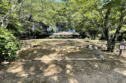
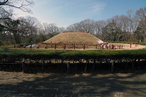
津宮から香取神宮神域までのルート途次に「神道山古墳群」を遙拝しながらの道が宮道として妥当性を感じる。この道をたどると3.2kmとほぼ常識的。神道山古墳群は前方後円墳1基(全長46m高さ4m)円墳11基からなる古墳時代後期の古墳群で1928(昭和3)年、考古学研究者の吉田文俊により発見された。香取神宮所管地域だという。
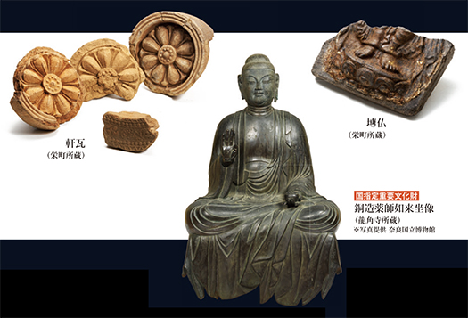
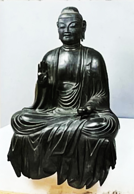
一方で香取神宮の東南約7kmに前方後円墳が集中する「城山古墳群」がある。その1号墳(6世紀後半?)からは中国製の三角縁神獣鏡(下総で唯一の出土例。)や環頭太刀4振など大量の副葬品が出土した。このため古墳の主は下海上国造ではとみられている。
どうも龍角寺古墳群とそれ以前の古墳群との対比のようにも思える。ヤマト王権と地域権力の間での葛藤、結果として「新興武力勢力」が支配権を握ったとも推測できる。ヤマト王権の東国支配の実相、興味深い。

English version⬇

Landing at Tsumiya from the Sea of Katori, Katori Jingu Shrine (1): Exploring the Three Shrines of Eastern Japan – 15
The sea of Katori appeared as an important area in Yamatotakeru’s eastern expedition. The most important “sea route” to Kashima on the opposite shore. From Ichino-torii and Tsumiya to Jingu Shrine. The first torii, Tsumiya, to the shrine

Tsumiya is called the “first torii” of Katori Jingu Shrine. It was built facing the present-day Tone River. This is in line with the legend that the gods would come ashore from the water’s edge.
The second map is an old map that I have been introducing in this series, showing the ancient topography of about 1,000 years ago. It is shown in the PDF document “Chapter 1: Background of the Historical Landscape of Katori City” compiled by Katori City.
The local newspaper “Chiba Nippo” article also includes the following description 〜The present Tone River basin, which is the inland area of the city, had a large inland sea called “Katori-kai”. The area is as large as the present Kasumigaura, Inba-numa, and Teganuma swamps. Water traffic on the Katorikai has been active since the Jomon period. In the Asuka-Nara period, there were the provinces of Inba and Shimotsunakami on the Chiba side of the Katori Sea, and Tsukuba, Naka, and Ibaraki on the Ibaraki side, and many ancient tombs were built on the coasts of these provinces. The Katori Sea played an important role in the Imperial Court’s control of the eastern provinces. The Chronicles of Japan and the Fudoki of Hitachinokuni describe the crossing of the Katori Sea during Yamatotakeru’s eastern expedition. The two shrines, Katori Jingu (Katori City) and Kashima Jingu (Kashima City), are located on opposite sides of the entrance to the Katori Sea, and were worshipped as deities for the pacification of the Emishi, with the former shrine positioned in Shimousa Province and the latter shrine in Hitachiniku Province. ~.
The third photo shows Katori Jingu Shrine as well as Kashima Jingu Shrine, where the “Shikinen Shinko Matsuri,” an event in which the deities are ferried across the water, is held once every 12 years on April 15 and 16 in the year of the Noon. Based on the ancient topography, such a procession ceremony confirms that the main route of the old Tokaido Highway was Kamisusa-Shimosusa-Jochiriku, and that the sea in Katori was the most important area in the Kanto region. This is probably why Katori and Kashima were coiled on opposite banks of the sea. This shows the probability that the Yamato royal authority enshrined Ise and these two shrines as the supreme deities.
Also, it is eye-opening to see that in Japanese shrine worship, these eight million gods are very active. Is this correlated with the fact that these two shrines are both warrior deities? The Kanto region’s role throughout history as a base area for launching offensives against the Emishi may also be symbolic of this.

The route from Tsumiya to the Katori Jingu Shrine, with a visit to the “Jindozan tumulus group” at the end of the route, seems reasonable as a palace path. The distance along this path is 3.2 km, which is almost reasonable. The Jindozan tumulus group is a group of tumuli from the late Kofun period, consisting of one 46-meter-long (4-meter-high) round tumulus and 11 circular tumuli. The area is said to be under the jurisdiction of Katori Jingu Shrine.
On the other hand, about 7 km southeast of Katori Jingu is the “Shiroyama Kofun Tumulus Group,” a cluster of posterior frontal round mounds. The first burial mound (late 6th century?) was found to contain a Chinese-made triangular-rimmed The first burial mound (late 6th century?) contains a Chinese triangular-rimmed animal and animal mirror (the only one excavated in Shimousa), four sword blades with ring heads, and other items. The burial mound No. 1 (late 6th century?) has a large number of burial accessories, including a Chinese triangular-rimmed mirror (the only one found in Shimousa) and four ring-headed swords. For this reason, the tomb is thought to have been owned by the Shimo-Kaijo-Kokuzo clan.
This seems to be a contrast between the Ryukakuji tumulus group and earlier tumulus groups. It can be inferred that the conflict between the Yamato Royalty and regional powers resulted in a “newly emerged military power” taking control of the region. The reality of the Yamato kingdom’s control over the eastern part of Japan is interesting.

【季節の「水入り」 のどかな水郷景観】


さてしばらくブログでは東国三社シリーズ、スピンアウトで龍角寺と古建築探訪。
本日はちょっとテーマ休止で「水入り」であります。写真は龍角寺を離れた途端に目に飛び込んできた名前もよくわからなかった景観。よく見てみたら「亀の子池」という名札を発見できました。
関東の利根川が東遷されていってその太平洋への注ぎ口の周辺、歴史年代では「香取の海」というような、瀬戸内海とも対比されるような内海地域が広がっていたとされるのですね。
そういう古代の歴史年代の風景の残滓が、こういった水郷の風景には残されている。
地球史の時代区分として最近は「人新世」、ようするに地球環境全体の変容に人類の活動が大きな要因としてカウントされるようになってきている。そのなかでも日本というの列島社会は、それがたぶん景観として目に見えて認識可能なのではないかと思います。
気候的には米作適地であり、そういうなかで多様な暴れ川などが洪水を繰り返す環境。一方で写真のような起伏景観形状が水郷的地帯にはたくさん広がっていた。
縄文海進のころにはこういう地形の場所に海が広がり、それこそ「海の幸・山の幸」によって縄文人の牧歌的な暮らし方を支えていたのでしょう。
そのあと海進が徐々に後退して陸地化が進み、活発に人間たちによる「自然改造」が展開されていって、広大な農耕適地が姿を現していったのでしょう。
江戸初期という特定された時期に利根川東遷という大自然改造が果たされて、まさに「人新世」的に国土改造がされて人間に暮らしやすいように自然改変されたのだ。まさに人新世の縮図かも知れない。
人為的自然改造の結果、江戸・東京という人類規模でも相当巨大な都市地域が誕生していったことも、きわめて特徴的なこととして抑えておくべきなのでしょう。
いったん改造されていけば過去は忘却されていくけれど、歴史を丹念にたどれば、そういう実相も浮かび上がってくる。そういう大きな人間活動の底流を抑えていくと、歴史事実の背景理解にも自然に波及していく切り口になるのでしょう。歴史はいろいろなことを教えてくれますね。
海辺の人間環境として房総半島南端の勝浦は、比較的に涼しい夏を楽しめるという。縄文の人びとの方が、酷暑に打ちのめされる現代人よりも快適な生き方だったのかもしれないと、この亀の子池の風景を見ていてこころに染みておりました。
ことしの猛暑、さてどこまで続くのか、北海道では少しはクールダウンしていると思いますが、本州以南各地のみなさん、ご自愛ください。

English version⬇

Seasonal “Mizuiri” – idyllic water town scenery
Remnants of the Jomon sea advance. The landscape of the water village reminds us of the “Sea of Katori”, which is similar to the Seto Inland Sea. The Japanese archipelago of Kanto may be a symbolic zone of the “Anthropocene. Japan and Kanto may be a symbolic zone of the “new human age.

For a while now, I have been blogging about the three shrines in the eastern part of Japan and spinning out to visit Ryukakuji Temple and other ancient architectural sites.
Today, we will pause for a moment on the theme of “Mizuiri” (entering the water). The photo is of a landscape that caught my eye as soon as I left Ryukaku-ji Temple, and whose name I could not quite make out. I took a closer look and found a nameplate that read “Kame-no-ko ike” (turtle pond).
The Tone River in Kanto was shifted to the east, and around its outlet to the Pacific Ocean, there was an inland sea area called “Katori no Umi” in historical times, which is said to be in contrast with the Inland Sea of Seto Inland Sea.
The landscape of these water villages retains remnants of the landscape of the ancient historical period.
Recently, human activities have come to be counted as a major factor in the “Anthropocene,” or the transformation of the global environment as a whole. Among these, Japan, as an archipelagic society, can probably be visibly recognized as a landscape.
Climatically, it is a suitable place for rice cultivation, and in such an environment, various rivers repeatedly flood the land. On the other hand, there were many undulating landscapes like the one in the photo in the suigo-like area.
At the time of the Jomon sea advance, the sea spread across these landforms, and the “delicacies of the sea and mountains” must have supported the pastoral way of life of the Jomon people.
Later, as the advance of the sea gradually receded and the land became more and more terrestrial, humans began to actively “transform nature” and vast areas suitable for farming emerged.
In the early Edo period (early 20th century), the Tone River was moved eastward, a major natural transformation was accomplished, and the land was modified in the manner of the “Anthropocene” to make it easier for people to live in the country. This may be the epitome of the Anthropocene.
The fact that Edo/Tokyo, an urban area of considerable size even on a human scale, was born as a result of the artificial natural transformation should also be kept in mind as a very characteristic fact.
Once a city is remodeled, the past is forgotten, but if history is carefully traced, such a reality will emerge. If we can suppress the underlying currents of human activity, it will naturally lead to a better understanding of the background of historical facts. History teaches us many things.
As a seaside human environment, Katsuura at the southern tip of the Boso Peninsula is said to enjoy comparatively cool summers. Looking at the scenery of Kame-no-ko Pond, I was deeply impressed by the fact that the Jomon people may have had a more comfortable way of life than modern people who are beaten down by the extreme heat.
I wonder how long the heat wave will last this year. I think it has cooled down a bit in Hokkaido, but I hope everyone south of Honshu will take care of themselves.

【二荒社と校倉、建築の輪廻転生・龍角寺⑦ 東国三社探訪-14】


東国三社探訪での「スピンアウト」だけれど、今回、成田空港の近傍の龍角寺を深掘りしてみた。当初の興味はその創建時の状況から、中央の古代氏族・蘇我氏との関係性に導かれたのだけれど、現地の様子を写真に収め、いくつかの物証、本尊や研究者のみなさんの探究に触れて、リアリティが自分のなかで形成されていった次第であります。古建築探索の醍醐味なのだと思います。
さてこの古刹・龍角寺境内敷地には「摂社」的な建築が2つ建っている。
ひとつは写真の「二荒〜ふたら〜神社」。この旧二荒神社本殿は、平成2年(1990)に現在の社殿に造替されたが、旧社殿は寛文8年(1668)の建立と解体部材の墨書から判明しているとのこと。下の写真は建て替えられる前の1668年当時からの旧社殿を撮影したもの。参照引用資料は、早稲田大学での龍角寺関連展示での発表資料:早稲田大学理工学術院・小岩正樹先生の「龍角寺の近世建築」より。
二荒山神社は宇都宮にあって日光信仰のルーツとも言われる。家康が「東照大権現」となって江戸城を守護する位置・日光に神となって眠るワケだけれど、そういった歴史変動がこの龍角寺境内にも及んで、摂社として建てられたのではないかと想像できる。資料によると、建築年代を示す墨書から考えれば建築年代は1668年である可能性が高いとされている。同時にこの建築に関わった工匠たちの個人名・属性もわかるとされた。
〜建立年と工匠名が記された部材の墨書きから大工・増渕伊兵衛守勝のほか「小工」「木引」の名が確認でき、いずれも常陸国下館市野辺村出身という。増渕伊兵衛はすぐ近くの安食村に居を構えており移住大工と言えよう。ほかに墨書に登場する人物には、龍角寺村領主であった佐倉藩主松平乗久や「龍角寺弟子玄榮」「大門善十郎よりきしん(寄進)」などとある〜<以上前掲資料より要旨抜粋>
こういう建築記録からは300年以上の時空を超えて伝わってくる感慨がある。

さらに、こちらの校倉建築は、明治初年の資料庫建築で、成田空港建設にともなってこの境内に移築保存されたものとされている。三里塚にあった宮内庁下総御料牧場から空港建設に伴って移築された。御料牧場自体は国有資産としてその敷地は成田空港に変貌していくことになる。
御料牧場は栃木県高根沢町に移転されたが、なぜその一部の校倉がこの地に移転されたのかの経緯は今のところ、不明。わたしたちの青春期の「成田空港反対闘争」という時代の「うずき」が、突然眼前に姿を現わす思い。やがて自分たちの生も歴史の中に眠っていく。輪廻転生・諸行無常と感慨深い。
建築と歴史状況を重ね合わせて先人の思いを掘り起こしていくという作業には、尽きぬ深みがある。一種のライフワークとして、今後とも取り組んでいきたいと思います。

English version⬇

Futaara Shrine, Koukura, and Ryukakuji Temple, the reincarnation of architecture (7) Exploring the Three Shrines of Eastern Japan – 14
From the calligraphy of Edo period architecture to the disappearance of artisans, and the lingering light of the Showa period and the lingering shadow of the Narita struggle. The cry of the architectural group that repose the souls of the times. The cry of the buildings that repose the souls of the times.

As a “spin-out” from my exploration of the three shrines in the eastern part of Japan, I decided to delve deeper into the Ryukakuji Temple near Narita Airport. My initial interest in the temple was guided by its relationship with the Soga clan, an ancient clan in the center of Japan, based on the conditions at the time of its founding, but after taking photographs of the site, and being exposed to several pieces of physical evidence, the principal image, and the research of researchers, a sense of reality was formed in my mind. I think this is the best part of exploring ancient architecture.
There are two “regent” buildings on the grounds of Ryukakuji Temple, an ancient temple.
One is the Futara Shrine in the photo. The main building of the former Futara Shrine was replaced with the current one in 1990, but it is known from the ink writing on the dismantled parts that the former shrine was built in 1668. The photo below shows the old shrine building from 1668, before it was rebuilt. Reference citation material is from a presentation material at an exhibition related to Ryukakuji Temple at Waseda University: “Early Modern Architecture of Ryukakuji Temple” by Dr. Masaki Koiwa, School of Science and Engineering, Waseda University.
Futaarayama Shrine is located in Utsunomiya and is said to be the root of Nikko worship. Ieyasu Ieyasu became “Tosateru Daigongen” and rested as a god in Nikko, the location that protects Edo Castle, and we can imagine that such historical changes must have extended to the precincts of Ryukakkakuji Temple, where the shrine was built as a regent shrine. According to the documents, the date of construction is highly likely to be 1668, based on the ink signatures that indicate the date of construction. At the same time, the names and attributes of the craftsmen involved in the construction are also known.
〜The year of construction and the ink inscriptions on the building materials show the name of the carpenter Ihee Masubuchi Morikatsu, as well as the names of “Kouko” and “Kibiki,” all of whom were from Nobe-mura, Shimodate City, Hitachinaka Province. Ihee Masubuchi is said to be an immigrant carpenter who settled in the nearby village of Ajiki. Other people who appear in the inked documents include Norihisa Matsudaira, lord of the Sakura domain, who was the lord of Ryukakuji Village, “Ryukakuji disciple Gensei,” and “Daimon Zenjuro, who donated the building to the temple.
These architectural records convey a sense of excitement that transcends the time and space of more than 300 years.

Furthermore, it is believed that this schoolhouse was built in the early Meiji period (early 1868) and was moved and preserved in the precincts of this building in conjunction with the construction of Narita Airport. It was moved from the Imperial Imperial Household Agency’s Shimofusa Imperial Farm in Sanrizuka to this location in conjunction with the construction of the airport. The Imperial ranch itself became a national property, and the site was transformed into Narita Airport.
The Imperial ranch was moved to Takanezawa-cho, Tochigi Prefecture, but the circumstances as to why a portion of the schoolhouse was moved to this location are currently unknown. The “tingle” of the “struggle against Narita Airport” of our youth suddenly appeared before our eyes. Eventually, our own lives will also fall asleep in history. I was deeply moved by the reincarnation of life and the impermanence of all things.
There is never a dull moment in the process of unearthing the thoughts of our predecessors through the superimposition of architecture and historical circumstances. I would like to continue working on this project as a kind of lifework.

【東北征夷拠点の豪族育成策・龍角寺⑥ 東国三社探訪-13】


さて龍角寺についての探索、いろいろな資料を参照しながら進めてみて、やはり気になるのはほかの関東地域の豪族の遺跡と比較して中央王権としても仏教導入始原期にもかかわらず、なぜこの地に本格的仏教寺院が開設されたのか、ということ。
また、この印波国造の支配地域のなかでも龍角寺周辺の古墳群と、それに先行する古墳群とは明確にその主体者の性格に差異が見られるという専門的所見があること。
こうした疑問は大きなナゾとして、ドンドン深まってきていた。
そういうなかでこの龍角寺のすぐ近くの「房総のむら」の「主任上席研究員」の白井久美子先生の発表文の一節に強く惹かれています。氏はとくに軍事機能を表徴する「毛彫り馬具」に注目されている。
〜6世紀以降の馬具製作には、鞍作りと仏師がともに関わったと考えられている。鞍作止利に代表される「止利派」は、推古朝における中心的な仏像製作者集団として飛鳥寺・法隆寺本尊を造像した点が知られているが、金銅薄板造りの馬装には彼らの関与が推定されている。特に、仏教色が強まった7世紀の金銅製毛彫馬具は、仏教美術の担い手によって製作された可能性の高い製品であり、新たな時代の息吹を映した馬具といえる。(中略)毛彫馬具の分布は、東日本に偏っているのが特徴(図1)で、特に、古代の東山道と東海道に集中し、群馬県(上毛野)と、静岡県(駿河)から茨城県(常陸)の分布が他を圧倒している。これらは、東北へ向かう内陸道、海道の要衝で、新式の道上型毛彫馬具は、東北
進出を図る王権の政策に応じて、活躍した東国軍団への勲章だったのかも知れない。〜
房総のむらは関東でも屈指の「民俗村」としてすばらしく、わたしも探索させていただき、ことし1月には全13回のブログシリーズでも紹介させていただいた。(連載1回目にリンクしたので辿ってみてください)

そういうことなので個人的体験としても親近感があり、そちらの主任上席研究員としての探究結果には強く刮目させられる。こうした物証に踏まえての論説には非常に説得力があります。王権は京都に遷都した桓武帝以降、東北地域への進出、征夷を活発化させるけれど、関東はその武力涵養地域として意図的に勢力を育成していったという説。それも600年代中期ころから意図していたということ。そういった意図からこの地域の勢力を武力の涵養地域権力として育てていった。
後の時代の武家の棟梁・源義家は、勿来の関という福島県太平洋側から東北に進出していくのだけれど、その根拠地・出撃準備地域として下総・印波の地域で、この龍角寺を営んだ勢力が役割を果たしたというのは非常に蓋然性が高いと思います。
日本史と建築の探究、点と線が繋がってくるような楽しさであります。

English version⬇

Ryukaku-ji Temple, a strategy for fostering powerful warriors as a base for the “conquest of the barbarians” in the Tohoku region (6): Exploration of Three Shrines in the East – 13
The royal power eventually began full-fledged conquest of the northeastern part of Japan, but it also fostered the power of Inba and other areas as a base for training military forces and nurturing Kanto samurai. The Inba forces and other organizations were fostered as a base for training the warriors of the Kanto region.

In my search for Ryuzaku-ji Temple, I consulted a variety of sources and found that, in comparison with the remains of other great families in other areas, the central royal authority was in the early stages of introducing Buddhism, so why was a full-scale Buddhist temple established in this area?
In addition, there is a specialized finding that there is a clear difference between the tombs around Ryukakuji Temple and those that preceded it in the area ruled by the Inba-no-Kokuzo, in terms of the character of the subjects of the tombs.
These questions were becoming more and more puzzling.
In this context, I was strongly attracted by a passage in the presentation by Ms. Kumiko Shirai, the “chief senior researcher” of “Boso no Mura” near Ryukakuji Temple. She is particularly interested in “hair-carved harnesses” that represent military functions.
〜It is thought that saddle makers and Buddhist priests were both involved in the production of harnesses from the 6th century onward. The “Toryi School,” represented by Kurazaki-Toryi, is known as the main group of Buddhist statue makers in the Suiko period who created the main statues of Asukadera and Horyuji temples, and their involvement in the production of gilt bronze thin plate horse mounts is also presumed. In particular, the gilt-bronze horse tack of the 7th century, when Buddhist colors became stronger, is highly likely to have been produced by the leaders of Buddhist art, and it can be said that it reflects the breath of a new age. (The distribution of carved bridles is characterized by a bias toward eastern Japan (Fig. 1), particularly concentrated along the ancient Higashiyama and Tokaido highways, with Gunma (Kamimono) and Shizuoka (Suruga) to Ibaraki (Hitachiniku) prefectures dominating the rest of the country. These were the key points on the inland and maritime highways leading to the Tohoku region, and the new style of roadside carved horse tack was used in the Tohoku region.
The new style of Doujo-style carved horse mounts may have been a medal of honor for the Eastern army corps that responded to the policy of the royal government to advance into the Tohoku region. ~.
The villages of Boso are some of the finest “folk villages” in the Kanto region, and I have explored them myself, introducing them in a 13-part blog series in January of this year. (Please follow the link in the first article of the series.)
As such, I feel a sense of familiarity with his personal experience, and I am strongly impressed by the results of his research as the chief senior researcher of the project. Your editorial based on such physical evidence is very persuasive. The theory is that the royal power intentionally fostered its power in the Kanto region as a place to cultivate its military strength, although it became more active in advancing into the Tohoku region and conquering the barbarians after the Emperor Kanmu moved the capital to Kyoto. This was the intention from the mid-600s. With this intention, the power in this region was nurtured as a regional power to cultivate military strength.
Minamoto no Yoshiie, the leader of the warrior class in the later period, advanced into the Tohoku region from the Pacific Ocean side of Fukushima Prefecture called Nakosunoseki, and it is highly probable that the forces that operated the Ryukakuji Temple in the Shimousa/Inba area played a role as a base and preparation area for his advance.
It is a pleasure to connect the dots and lines between Japanese history and architectural exploration.

【基壇が残る「金堂」跡・龍角寺⑤ 東国三社探訪-12】


龍角寺の発掘研究については早稲田大学が積極的に関与して、その成果を資料として公開してきている。2022年10月開催の早稲田文化芸術週間2022において「下総龍角寺展関連シンポジウム」が開かれ、その発表がまとめられて公開されている。
この龍角寺の建立、そしてそれに先立つ古墳群氏族が繁栄していた地域名として古代の「印波」という地名が資料に見える。(千葉県立房総のむらの研究者・白井久美子氏論文より)
氏の論考では龍角寺古墳群の歴史時期は「飛鳥に宮殿が置かれた「飛鳥時代」前期、国を挙げて中国隋・唐王朝の律令制度にならった新たな体制に転換する時代にあたる。また、異国の宗教であった
仏教を本格的に取り入れた時期でもあった。」とされている。
法隆寺の創建が607年とされる。一方この龍角寺は寺伝では創建年は709年とされるが、650年から660年頃に創建されたとの説を唱える研究者もいる。本尊の頭部制作年もその時期とされる。
この「印波」という地名からその氏族名を仮定すれば、印波氏というのは、関東の地方豪族として群馬県上野(こうづけ)の上毛野(かみつけの)氏とも比肩できるような氏族だったと思える。上毛野氏は歴史年代での浅間山火山噴火で大打撃を受けて地域崩壊したと想像できるけれど、この仮称・印波氏もあまり資料に見られない。印波国造時代からこの地域有力豪族と思えるが資料が少ない。
この龍角寺の創建には地域豪族としてスポンサーとなったことが推定できるが、寺伝にも龍の頭蓋骨のようなお伽噺はあっても、氏族名を証するものはないようだ。
想像すれば、古代の国名特定(令制国)のときにこの一帯地域は国名として「下総」という地名になっていったけれど、その国名が一般化するなかで氏族名も衰退していったのだろうか。令制国の成立時期は早ければ大化元年(645年)遅くとも大宝元年(701年)とされるので、どうもこの龍角寺の創建年代とも符合してくる。中央と鄙の関係性も関わってくるか。


上の写真のように江戸期に建築された金堂の古写真(昭和7年当時)が早稲田大学でのシンポ記録では公開されていた。同シンポでの早稲田大学理工学術院・小岩正樹氏の分析記事。現在の龍角寺境内に置かれた復元図に表された金堂と相似した建築。この古写真の金堂は元禄5年(1692)に罹災したことを受け元禄11年(1698)に建立されたと。昭和25年(1950)に倒壊の危険のため解体された。
1692年以前の龍角寺金堂は、寺伝の709年創建時からのものだったのか不明だけれど、今に残る基壇礎石など、きのう見た塔の礎石のように創建時の設計趣旨に忠実に従うのが日本の匠の伝統と考えられるので、古写真とよく似た建築が歴世、この地にあり続けたと想像できる。
いろいろ想像力が導いてくれる木造の歴史的建築の探訪であります。

English version⬇

The site of “Kondo,” where the platform still remains, Ryukakuji Temple (5): Exploring the Three Shrines of the Eastern Provinces – 12
Research results were presented at the Waseda Symposium. Traces of local powerful families from the Kunizukuri period. The name of the country was changed from “Inba” to “Shimousa” during the establishment of the state under the Order of the Emperor. The name was changed from “Inba” to “Shimousa” in the country under the Order of State.

Waseda University has been actively involved in the excavation and research of Ryukakuji Temple, and the results have been made public in the form of documents, including a symposium related to the Shimousa Ryukakuji Temple Exhibition held during the Waseda Culture and Arts Week 2022 in October 2022.
The ancient place name “Inba” can be seen in the documents as the name of the area where the Ryukaku-ji Temple was built and the preceding tumulus clan flourished. (From an article by Kumiko Shirai, a researcher at Chiba Prefectural Boso no Mura.)
In her discussion, Ms. Shirai states that the historical period of the Ryuzumadera Kofun Tumulus Group was the early Asuka Period, when palaces were established in Asuka and the entire country was converted to a new system based on the Ritsuryo system of the Sui and Tang Dynasties in China. It was also the period when Buddhism, a foreign religion, was introduced in earnest.
It was also the time when Buddhism, which was a foreign religion, was introduced into the country in earnest. The founding of Horyu-ji Temple was in 606.
Horyu-ji Temple is said to have been founded in 607. According to temple tradition, Ryukaku-ji Temple was founded in 709, but some researchers believe that it was built between 650 and 660. Some researchers believe that the temple was founded between 650 and 660, the year when the head of the main image was created.
If we assume the name of the clan from the place name “Inba,” it is likely that the Inba clan was a local clan in the Kanto region, comparable to the Kamitsuno clan of Kozuke in Gunma Prefecture. While the Kamimeno clan was hit hard by the volcanic eruption of Mt. Asama in the historical period and the region collapsed, the Inba clan, as it is tentatively called, is also not well documented. The Inba clan seems to have been a powerful family in this area since the Inba Kunizou period, but there are few data on them.
It can be presumed that they sponsored the construction of Ryukakuji Temple as a local powerful family, but there is no evidence of their clan name in the temple legend, even though there is a fairy tale of a dragon skull.
It is imaginable that the name of this area was changed to “Shimousa” when the ancient name of the country was specified (Reisei Kuni), but as the name of the country became common, the clan names also declined. The date of establishment of the country as a state under the ritsuryo system is said to be the first year of Taika (645) at the earliest, and the first year of Taiho (701) at the latest, so it seems to coincide with the founding date of Ryukakuji Temple. The relationship between the central and remote areas may also have something to do with it.

As shown in the photo above, an old photo of Kondo built in the Edo period (as of 1932) was available in the symposium record at Waseda University. An analytical article by Masaki Koiwa, School of Science and Engineering, Waseda University, at the same symposium. The architecture is similar to the Kondo shown in the restored map placed in the precincts of the present Ryukakuji Temple. The Kondo shown in this old photo was built in 1698 after the temple was damaged in 1692. It was dismantled in 1950 due to the danger of collapse.
It is unclear whether the Ryukakuji Kondo was built before 1692 or in 709, according to the temple’s legend. However, it is considered to be a tradition of Japanese craftsmen to faithfully follow the design intent of the original construction, as seen in the foundation stones of the pagoda we saw yesterday, including the foundation stones of the platform that remain today.
This is an exploration of historical wooden architecture guided by various imaginations.

【塔心柱の礎石「不増不減石」・龍角寺④ 東国三社探訪-11】


龍角寺本堂(現本堂跡)の東約13間(約23.4m)にこの不思議の石、不増不減の石はある。これは龍角寺縁起が伝える三重とも七重とも言われる「塔」の心礎石とされている。なお「不増不減」は般若心経の一節で仏教思想の根幹にかかわるキーワード。ネーミングからも仏教教化の思惑が偲ばれる。
この心礎は長径249cm、短径203cmの花崗岩の表面を削って平らにして、中央に直径81.8cm、内径66.6cm、深さ12.1cmの円孔を穿っている。その両端には水気抜きの小溝を刻んでいる。この心礎石の大きさから推定して、塔の高さは33mほどと推定されている。法隆寺・五重塔では基壇からの高さ31.5mとされているので、ほぼ同程度の塔だったことになる。
また、この穿った柱穴は雨が降っても日照りになっても中に蓄えられた水は増えもせず、減少することもないとされて、龍角寺の七不思議のひとつに数えられているとのこと。この七不思議という説話も面白いのだけれど、あまりにも日本昔話的横道なので自制(笑)。興味ある方はリンク先・千葉県栄町HPでお楽しみください。
その七不思議はどうも水とか、沼とかのこの地域特有の説話だと感じさせる。いやそもそも、龍角寺自体、和銅2年(709年)に竜女化来し一夜のうちに諸堂(金堂、塔)を建立したと伝えられて、さらに寺宝として命名に関わる「竜伝説」の小龍の頭部のミイラが保有されていることでも有名。
〜天平3年(731年)の夏はことのほか暑く水不足となり、時の聖武天皇の命により、龍角寺の釈命上人が雨乞いの祈祷を行うと、印旛沼の主の小竜が大竜に殺されることを承知でその願いを聞き入れ、七日七晩雨を降らせてくれた。雨が上がった後、沼のほとり3ヶ所で分断された竜の死体が見つかり、上人は竜との約束どおり頭を龍閣寺に葬り寺の名を龍角寺と改めました。〜
オイオイ、でありますがそういった伝説の霞に深く包まれている。
この不増不減の石は国指定史跡の重要な構成要素であり、本尊の銅造薬師如来座像は国指定重要文化財としても登録されている。戦前期には国宝にも指定されていたのだ。
北海道人としては、本州地域での地域史の深遠さを深く思い知らされる気分。史実としては蘇我氏由来の国家的なプロジェクトとしてこの地に龍角寺は創建されたことは間違いないけれど、鄙の人びとに宗教性の「ありがたさ」を伝えていくときに、龍だとか、奇跡・不思議譚などのオブラートでくるんで伝えた方がわかりやすかったのではないかとも推測できる。
この龍角寺の創建譚のなかに、はじめて仏教という思想に触れた人びとへのそのような「教化」の思惑が隠されていると思えてくる。
おっと、こちらもついつい想像力の魅力的なワナに落っこちそうであります(笑)。

English version⬇

The foundation stone of the central pillar of the pagoda, “Non-increasing and Non-decreasing Stone”, Ryukaku-ji Temple 4: Exploration of Three Shrines in Eastern Japan – 11
The foundation stone of the pagoda’s central pillar, the “nonincreasing and non-reducing stone,” is the foundation stone of the pagoda’s central pillar, the “nonincreasing and non-reducing stone. …

This mysterious stone is located approximately 13 ken (23.4 m) east of the main hall of Ryukakuji Temple (the current site of the main hall). It is believed to be the cornerstone of a three- or seven-story “pagoda,” according to the legend of Ryukakuji Temple. The phrase “nonincrease/non-decrease” is a key word in the Heart Sutra, which is the foundation of Buddhist thought. The naming of the pagoda also suggests a desire for Buddhist indoctrination.
The cornerstone is made of granite with a long diameter of 249 cm and a short diameter of 203 cm, with a flattened surface and a circular hole in the center with a diameter of 81.8 cm, an inside diameter of 66.6 cm, and a depth of 12.1 cm. Small grooves for drainage were carved at both ends. Based on the size of this central foundation stone, the tower is estimated to be about 33 meters high. The five-story pagoda at Horyu-ji Temple is estimated to have been 31.5 m high from the base, which means that the pagoda was about the same height.
It is also said that the water stored in this hole neither increases nor decreases even in rain or shine, and is considered one of the Seven Wonders of Ryukakuji Temple. This is one of the Seven Wonders of Ryukakuji Temple. The story of the Seven Wonders is interesting, but it is too much like a Japanese folktale, so I restrain myself (laugh). If you are interested, please visit the website of Sakae Town, Chiba Prefecture.
The Seven Wonders of Sakae are apparently unique to this area, with its water, swamps, and such. To begin with, Ryukakuji Temple itself is said to have been visited by a dragoness in 709 and built various halls (Kondo and Pagoda) in a single night, and is also famous for holding a mummy head of a small dragon, which is related to the “dragon legend” of its naming, as a temple treasure.
〜In the summer of 731 (Tempyo 3), it was extremely hot and there was a shortage of water. After the rain had stopped, the corpse of the dragon was found split up in three places along the banks of the swamp. As promised to the dragon, the shonin buried the head in Ryukaku-ji Temple and renamed the temple Ryukaku-ji Temple. The head of the dragon was buried at Ryukaku-ji Temple and the temple was renamed Ryukaku-ji Temple. ~.
It is deeply shrouded in a haze of legends.
This stone of non-increase and non-reduction is an important component of the nationally designated historic site, and the main statue of Yakushi Nyorai, a bronze statue of Yakushi Nyorai, is also registered as a national important cultural property. It was also designated as a national treasure in the prewar period.
As a Hokkaido native, I am deeply reminded of the profundity of local history in the Honshu region. Although the historical fact is that Ryukakuji Temple was built here as a national project of the Soga clan, it may have been easier to convey the “gratitude” of religiosity to the local people by wrapping it in the language of dragons, miracles, and mysterious stories.
In this tale of the founding of Ryukaku-ji Temple, it seems that this kind of “indoctrination” of people who first came into contact with the idea of Buddhism is hidden.
I am about to fall into the fascinating trap of imagination (laugh).

【古墳から仏教寺院建築へ・龍角寺③ 東国三社探訪-10】


この龍角寺のある周辺は関東でも有数の古墳集積地域。古墳時代後期(6世紀)から終末期(7世紀)の古墳群。現在確認されている古墳の総数は115基。関東では上野(こうづけ)を拠点とした上毛野氏勢力が有力とされるけれど、この龍角寺周辺もその集積ぶりでは圧倒的な大規模古墳群。印旛沼に面する台地縁辺部に6世紀の円墳や前方後円墳が並んでいる。
関東有数の古民家園・千葉県立「房総のむら」敷地内にあって多くの古墳が良好に保存されている。指定範囲内には93基の古墳が含まれるとのこと。
この古墳群は、近傍に所在する白鳳期創建の龍角寺との密接な関連が想定される。この古墳群と周辺遺跡の背景には、印旛沼北岸から香取海南岸に本拠を置いた一豪族が、大和王権の東国支配が確立されていく過程で中央王権の代行者としての地位を獲得し、律令国家成立後も国家機構の一翼を担う在地勢力となったことが考えられるのですね。
写真は2022年10月の早稲田大学會津八一記念博物館での「下総龍角寺再考」シンポ資料より。古墳は龍角寺古墳群101号の外観。
全国で古墳文化はある段階から急減していくけれど、それは多く「寺院建築」に置き換わっていった王権勢力の権威文化の移り変わりを表しているのだと思える。それは同時に八百万の神が、神宿る自然を依り代としてきたのに対して、対比的だと思える。
列島の自然環境に帰依する自然崇拝系の「宗教」といえる八百万の「威信建築」としては自然改造の古墳づくりとその形状を権力象徴としたのだろうが、その次の新時代として仏教寺院とその建築伽藍様式が権威の象徴に変化していったと言える。
そういう権威付けのシンボルとしては、本尊の仏像とその表情ぶりはそれまでの古墳の形状以上にわかりやすく権威の裏付けを「見える化」させたものと推定できる。そしてそれまでの自然崇拝という宗教性から、仏教思想という人間化された宗教が導入された。

具体的な表情を持った「神性」というものに縄文由来の人びとがどのように反応して、それを受容していったのか、想像力が刺激される。それまでは地域王権の具体的な表徴としては古墳を見せていたものが、ある時期から突然、仏教伽藍にそれが変わり、さらに具体的な人間の表情を持った「みほとけ」が出現してきたワケだ。
現実の日本史で展開していったのは、八百万と仏教は共生的に併存していったということ。大陸的な傾向では二者択一的に偏っていくものが、日本では併存していった。この関東東部では、鹿島神宮や香取神宮と古墳群、そして龍角寺という宗教性がそれぞれで併存していった。後の世の成田山新勝寺もしかり。
王権権力と宗教性との絡み合いが、複雑な過程を辿ったということなのでしょうね。

English version⬇

From Kofun Tumulus to Buddhist Temple Architecture, Ryukakuji Temple (3): Exploring the Three Shrines of Eastern Japan – 10
The form of manifestation of power changed from ancient burial mounds to Buddhist temples. The area around Ryukakuji Temple is a pinnacle of this ancient period. The temple is located in the vicinity of Ryukaku-ji Temple.

The area around the Ryukakuji Temple is one of the most concentrated areas of kofun tumuli in the Kanto region. The tombs date from the late Kofun period (6th century) to the end of the Kofun period (7th century). The total number of confirmed kofun tumuli is currently 115. In the Kanto region, the Kamimono clan, based in Kozuke, is the dominant force, but the area around Ryukakuji Temple is also by far the largest tumulus cluster in the Kanto region. On the edge of the plateau facing Obanuma, there is a row of 6th-century round mounds and posterior-rectangular mounds.
Many of the tombs are well preserved within the grounds of the Chiba Prefectural “Boso no Mura,” one of the largest old private gardens in the Kanto region. The designated area includes 93 burial mounds.
It is assumed that this tumulus group is closely related to the nearby Ryukakuji Temple, which was founded in the Hakuho Period. So the background of this kofun tumulus group and the surrounding ruins suggests that a powerful tribe based on the northern coast of the Inba Marsh to the southern coast of the Katori Sea acquired a position as an agent of the central royal power in the process of establishing the Yamato royal power’s rule in the East, and became a local power that played a part in the state structure after the Ritsuryo state was established.
The photo is from the “Reconsidering Shimousa Ryukakuji Temple” symposium held at the Aizu Yaichi Memorial Museum of Waseda University in October 2022. The tumulus is the exterior of the Ryukakuji Tumulus Group 101.
The tumulus culture declined sharply after a certain stage in the history of Japan, but I believe that this represents a shift in the culture of authority of the royal power, which was replaced by “temple architecture” in many cases. At the same time, this is in contrast to the 8 million deities who have taken refuge in the nature in which they dwell.
The “prestige architecture” of the eight million nature-worshipping “religions” that took refuge in the natural environment of the archipelago may have been the mound structures modified by nature and their shapes as symbols of authority, but in the next new era, Buddhist temples and their architectural temple styles became symbols of authority.
As such symbols of authority, the main Buddha image and its facial expression are more easily understood than the shape of the kofun tumulus, and it can be assumed that they “visualized” the support of authority. The religious nature of nature worship that had existed up to that point was replaced by the humanized religion of Buddhist thought.

It is stimulating to the imagination to see how people of Jomon origin reacted to and accepted the “divinity” that had a concrete expression. The Jomon had previously displayed kofun as a concrete expression of local kingship, but at some point in history, this was suddenly replaced by Buddhist monasteries, and “mihotoke” appeared with a more concrete human expression.
What has developed in actual Japanese history is the symbiotic coexistence of the eight millions and Buddhism. What would have been a continental trend toward a bias toward one or the other, in Japan they coexisted. In the eastern part of the Kanto region, the Kashima Shrine, the Katori Shrine, the ancient burial mounds, and the Ryukakuji Temple were all religious entities that coexisted with each other. The same is true of the later Naritasan Shinsho-ji Temple.
It must be said that the intertwining of royal power and religiosity was a complicated process.

【奈良大仏より古い本尊頭部・龍角寺② 東国三社探訪-9】


龍角寺は廃寺になった寺院なので、記録などはなかなか辿ることが難しい。画像の情報特定も困難を究めました。しかし、そういうなかで本尊・薬師如来はその制作年代が白鳳期にまで遡ることが美術史的に解明されているという。白鳳期とは、645年の大化の改新から710年の平城京遷都までの飛鳥時代の文化。法隆寺の建築・仏像などによって代表される飛鳥文化と、東大寺仏像、唐招提寺建築などの天平文化との中間期。
奈良東大寺の大仏よりも古い時代であり、鞍作止利が活躍した時代のすぐあとの時代に彫像されたものだといわれているのですね。
残念ながらこの龍角寺は歴史年代、幾多の火災に遭遇し現存する本尊座像は頭部と胴体部で制作年代に違いがあり、江戸期に胴体部は復元されたものとされている。上の写真画像は龍角寺 薬師如来像 頭部石膏型抜 早稲田大学會津八一記念博物館展示より。その下は現在龍角寺廃寺に建てられている「拝殿」正面画像。裏手には「収蔵庫」があって本尊薬師如来はあるいはそちらに収蔵されていると思われます。鹿島神宮参詣途中での立ち寄りだったので、参観は望むべきもありませんでした。
<龍角寺本尊「薬師如来」座像の情報については観仏日々帖さん記事から学ばせていただきました。同ページには写真画像も昭和7年当時の雑誌「宝雲」(第3冊)からのものなどが掲載されており、ぜひ参照ください。>
同ページには東京帝国大学名誉教授、古社寺保存会委員だった関野貞氏(1868~1935)によるこの仏像の鑑定結果を伝える当時の「龍角寺銅造薬師如来像及古瓦片」(歴史教育7巻4号1932年刊)記事もある。
「其様式手法は、明かに寧楽時代の初期の特色をあらわし、薬師寺東院の聖観音に次ぎて法隆寺の夢違観音や新薬師寺の香薬師如来及び深大寺の釈迦如来と殆んど同時代に成つたもので.稀れに見る所の傑作である。」という記載。
飛鳥寺の大仏さんにはゾッコンにさせられているわたし。飛鳥寺は蘇我氏の影響の強い寺院ですが、そのほぼ同時代に平行的に関東にこうした仏教導入期の信仰心を素朴に伝えてくれる物証が存在している。
その薬師如来の表情には最初期導入仏教のこころが素朴に宿っている。とくに眉目の切れ長ぶりには、人間の「やさしさ」感が象徴されているように思われる。仏教にはじめて接したひとびとがどのように「受容していったのか」顔の表情というものが果たした役割は巨大だったに違いない。
東大寺以降、やがて奈良期には全国に「国分寺」が造営されていくけれど、この龍角寺は、それより時代を遡って、蘇我氏は関東にまで強い影響力を持っていたということですね。
先進地域・畿内に対して縄文以来の暮らしを紡いできたひとびとが多数派だっただろう関東地域で、こうした仏像さんが辿ったであろう、多くの人びととの出会い。
こうした画像から、いろいろなことが「伝わって」くるように思われます。

English version⬇

The head of the main image of Yakushi Nyorai, which is older than the Great Buddha of Nara, at Ryukakuji Temple (2)
The image of the Yakushi Nyorai (the Medicine Buddha) is a very old image. How was it received in Kanto, where the Jomon spirit still lingers? …

Since Ryukakuji Temple is a defunct temple, records and other information are difficult to trace. It was also difficult to identify the information on the images. However, in such a situation, it has been clarified in art history that the main statue, Yakushi Nyorai, dates back to the Hakuho period. The Hakuho period refers to the Asuka period of culture from the Taika Reform of 645 to the transfer of the capital to Heijo-kyo in 710. It was an intermediate period between the Asuka culture represented by the architecture and Buddhist statues of Horyu-ji Temple and the Tempyo culture represented by the Buddhist statues of Todai-ji Temple and the architecture of Toshodai-ji Temple.
It is said to be older than the Daibutsu statue at Todaiji Temple in Nara, and was carved in the period immediately after the period in which Kurusaku Noritoshi was active.
Unfortunately, Ryukakusokuji Temple suffered from numerous fires during its history, and the existing seated statue of the principal image has a different production date for the head and the body, and it is believed that the body was restored during the Edo period. The photo above is a plaster cast of the head of the statue of Yakushi Nyorai from the exhibition at the Aizu Yaichi Memorial Museum of Waseda University. Below is an image of the front of the hall of worship, which is now built in the abandoned Ryukakkakuji Temple. There is a “storage room” in the back of the temple, and the main statue of Yakushi Nyorai is probably stored there. Since we stopped by on our way to Kashima Jingu Shrine, we could not visit the temple.
<I learned about the seated statue of Yakushi Nyorai, the principal image of Ryukakuji Temple, from an article written by Kanbutsu Nichijitsumecho. Please refer to the same page, which also includes a photo image from the magazine “Houn” (Vol. 3) from the 7th year of Showa (1932). > “Tokyo Imperial University
On the same page, there is an article by Sada Sekino (1868-1935), a professor emeritus at Tokyo Imperial University and a member of the Society for the Preservation of Ancient Temples and Shrines, on the results of his appraisal of this Buddhist statue, “Ryuzokuji Bronzo-Yakushi Nyorai Zo and Old Tile Fragments” (History Education Vol. 7, No. 4, published in 1932).
The style and technique clearly show the characteristics of the early Neiraku period, and it was made almost at the same time as the Sei-Kannon in the Toin of Yakushiji Temple, the Yumekai-Kannon in Horyuji Temple, the Koyakushi Nyorai in Shin-Yakushiji Temple, and the Shaka Nyorai in Jindaiji Temple. It is a rare masterpiece. The Daibutsu in Asukadera is a rare masterpiece.
I have a crush on the Great Buddha of Asukadera Temple. Asukadera Temple is a temple strongly influenced by the Soga clan, but there is evidence in the Kanto region at about the same time that conveys the simple religious beliefs of the period when Buddhism was introduced to the region.
The expression on the face of the Yakushi Nyorai (the Medicine Buddha) is simple and expressive of the spirit of the early introduction of Buddhism. In particular, the long, slanted eyebrows seem to symbolize a sense of human “gentleness. Facial expressions must have played a huge role in how people who first came into contact with Buddhism “accepted” it.
After Todaiji Temple, Kokubunji temples were built throughout the country during the Nara period (710-794), but this Ryukakuji temple shows that the Soga clan had a strong influence as far back as the Kanto region.
In the Kanto region, where the majority of people would have been those who had been living since the Jomon period, as opposed to the more advanced Kinai region, these Buddhist statues would have encountered many people.
These images seem to “convey” a variety of things.

【古代蘇我氏の痕跡・龍角寺① 東国三社探訪-8】


古代の関東平野の状況を実体験する旅、いわゆる「東国三社」という鹿島・香取・息栖の3つの神社探訪ではありますが、実はもうひとつ深く興味を刺激されていた「龍角寺」。現在は廃寺跡が残っている。
画像は、古代での寺のありようを伝える現地説明板でみた復元絵画・配置図とそれに対照した正面外観写真。写真の手前側には礎石だけになった仁王門跡もある。
こちらは成田空港にほど近い「栄町」にあって、古代関東の地形を感じさせる印旛沼のような水郷的雰囲気も残っている。こうした立地環境にあり、交通も困難な地域と認識される地域でありながら、この龍角寺はその創建をおおむね600年代中期頃まで遡ることが知られている。
「当地には古代から仏教寺院が存在したことは間違いない。発掘調査によって、南大門から入り、中門を抜け、左手に金堂、右手に塔、そしてその奥に講堂が配されるという、いわゆる「法起寺式伽藍配置」の遺構が検出され、創建瓦は周縁に三重園文のある単弁八葉蓮華文の山田寺式の系譜を持つ軒丸瓦である。関東でもいくつかの寺院跡で山田寺式の軒丸瓦が出土しているが、その中でも最も古い様式。」
「寺の南には最後の前方後円墳といわれる浅間山古墳や、畿内の大王陵を凌駕する終末期最大の方墳龍角寺岩屋古墳などがあり、馬来田の上総大寺廃寺(千葉県木更津市)、武社の真行寺廃寺(同山武市)、上毛野の山王廃寺(群馬県前橋市)などとともに、国造制から律令制への移行段階に建立された印波国造の領域の初期寺院とされ、畿内以外では最古にあたる寺院。龍角寺岩屋古墳は典型的畿内型終末期古墳であり、畿内中枢との密接的な関係なしに理解できないという。」
「方墳は用明天皇陵の春日向山古墳や、推古天皇陵である山田高塚古墳をはじめ、蘇我馬子の墓の可能性の高い石舞台古墳といったように、蘇我氏関係の墳墓に採用されている。さらに規模においてそれらを凌駕しており、当時の最大権力・蘇我氏が造営に深く係っていたと推測される。龍角寺の創建「瓦」も一族の蘇我倉山田石川麻呂によって創建された山田寺式の瓦を採用していることから、龍角寺造立者は龍角寺岩屋古墳の被葬者の系譜下にあり、蘇我氏系の氏族であったとする見解もある。」〜以上、Wikipediaより。
引用が長くなってしまったけれど、この廃寺跡を彷徨っていると各所で気の遠くなる説明記述板がボーッとした脳味噌に怒濤のように降り注いでくる(笑)。
とても一度の訪問では咀嚼しきれないほどの興味津々な歴史のナゾが襲ってくるのであります。
わたしは密かに伊能忠敬さんを尊崇しているのですが、かれは健康人生を心がけて、人生の晩年期にこそ日本人のための活動を行った。はるかな落第生的な凡百として、せめてこういった昔人の痕跡と向き合っていきたいと考えています。
この廃寺跡から、そういった空気感が立ち上ってきて無性に揺さぶられた次第です。

English version⬇

Traces of the Ancient Soga Clan, Ryukakuji Temple (1): Exploration of Three Shrines in the East – 8
This is a region in Kanto that can be traced back to the time of the Kunizukuri. The most advanced temple architecture in the Kinai region at that time was transplanted to the Kanto region. The influence of the Soga clan is strong in its construction. The Soga clan’s influence is strong in the construction of this temple.

Although this is a trip to actually experience the conditions of the Kanto Plain in ancient times, the so-called “Three Shrines of the East,” an exploration of the three shrines of Kashima, Katori, and Sosu, there was actually one more deeply stimulating interest: the Ryukakuji Temple. Today, the ruins of the abandoned temple remain.
The image shows a front exterior view contrasted with a restored painting and layout seen on a local explanatory board that tells how the temple was in ancient times. In the foreground of the photo are the ruins of the Niomon Gate, which is now only a foundation stone.
This temple is located in Sakae-machi, near Narita Airport, in an area that still retains the atmosphere of a water village like Obanuma, which reminds us of the topography of the ancient Kanto region. Despite its location in such an environment, and despite the fact that the area is considered difficult to access, Ryukakuji Temple is known to have been founded in the mid-600s.
There is no doubt that a Buddhist temple has existed in the area since ancient times. Excavations have revealed the remains of a so-called “Hokki-ji style” temple layout, with the main hall on the left, the pagoda on the right, and the lecture hall in the back, entered through the main south gate, and with eaves round tiles in the Yamada-dera style with a single-petaled eight-leaf lotus flower design with a threefold garden pattern on the periphery. This is the oldest of the Yamadadera style eaves round tiles that have been excavated from several temple sites in the Kanto region.
To the south of the temple are the Asamayama Kofun Tumulus, said to be the last forward-rear round burial mound, and the Ryukakuji Iwaya Kofun Tumulus, the largest square burial mound of the Terminal Period, surpassing the great imperial tombs in the Kinai region. It is the oldest temple outside the Kinai region. The Ryukakuji Iwaya burial mound is a typical Kinai-type Terminal Period burial mound, and cannot be understood without its close relationship to the Kinai center.
The square burial mounds are used for tombs related to the Soga clan, such as the Kasuga Mukoyama burial mound for Emperor Yomei, the Yamada Takatsuka burial mound for Emperor Suiko, and the Ishibutai burial mound, which is likely to be the tomb of Soga Umako. The tombs are even larger in scale than those of the other tombs, suggesting that the Soga clan, the most powerful clan at that time, was deeply involved in their construction. The “roof tiles” used in the construction of Ryuzumakuji Temple are also in the Yamadadera style, which was created by the family of Soga Kurayamada Ishikawamaro, which leads some to believe that the builders of Ryuzumakuji Temple were of the Soga lineage and descended from the family of the buried in the Ryuzumakuji Iwaya tumulus. 〜The above is from Wikipedia.
The above is from Wikipedia. I have been quoted for a long time, but as I wandered around the ruins of this abandoned temple, I was bombarded with dizzying explanations and description boards at various places like a raging wave in my foggy brain (laugh).
(Laughs). I was bombarded with so many interesting historical riddles that I could not digest them all in a single visit.
I secretly revere Mr. Tadataka Ino, who tried to lead a healthy life and did activities for the Japanese people only in the later years of his life. As an ordinary person who is far from being a dropout, I would like to at least face the traces of these ancient people.
I was moved by the atmosphere that rose up from the ruins of this abandoned temple.

【芸術的な石灯籠と寄進者たち 東国三社探訪-7】


連載ブログのきっかけだったSuica紛失、地元警察からの発見のお知らせと再発行手続きの全プロセスは無事に完了して、残額6,500円ほどのカードはいまわたしの財布に仕舞い込まれています。
鹿島神宮への尊崇のこころは歴世の人びとが共有してきたモノでしょうが、わたし自身も前述の経緯から、多くの人びとの善意の積層に深く感謝しております。
そんなことで最後にちょっと驚かされていた鹿島神宮本殿脇の「石灯籠」について。
写真のような本体のお姿なのですが、素性のわかるような記録とかはWEB上でも、どうしても見つかりません。しかし、石を加工してここまでの装飾性を実現させるのは驚異的。まぁわたしもいつも目をこらして石灯籠を注視してきた経験はないのですが、ふとこの石灯籠を見て、思わず、シャッターを切っていた次第なのです。
頂部の傘の部分には端部に飾りが付けられて反り返っている。その下の灯明部にはステンドグラス並みのこまかな格子枠が端正に刻印されている。その下の胴体部には多様な紋様、たぶん十二支を意識したのではと想像できる彫刻模様が美しく刻印されている。
外部からは、灯明部に火を点けるにはどうするのか不明でしたが、その造形の巧みさには、そしてその本体が石であることを重ね合わせると、江戸期と思われる工芸技術のレベルの高さを強く印象づけられる。


台座の下には、たぶん寄進者とおぼしき名前がズラッと記載されている。
「世話人」とあるので、たぶん鹿島神宮への篤い信仰心を持った人びとが浄財を集めて石工の名人に制作を依頼して、鹿島神宮にお願いして奉納されたものでしょう。はるかな昔人のみなさんの篤志の高さに、令和の現代、その神徳で救済されたひとりとして、まことに頭の垂れる思い。
世話人には「橘(?)町二丁目」と住所の記載がある。橘町とすれば江戸時代の日本橋周辺にこの町名がある。そして藤井屋とか、萬屋、松坂屋、丹波屋、百足屋などの屋号が見えているので、これらの商人たちが連名で行った寄進行為ではないかと想像できる。
続いてもうちょっと寄進額が少額だったと推定できる名簿記載からも、遠州屋とか、相模屋、さらには「銭屋」などの商号屋号が記されている。ここにも「神田相生町」というような地名も記されていることから、やはり江戸の商家たちが寄進したものと推定されるのですね。
江戸から鹿島までは現在でも92.6kmで徒歩であれば19時間以上の距離。江戸時代のふつうの感覚で考えると、3-4日の移動距離。往復と考えると1週間程度の距離感ですが、神田の商店主たちの信仰心、鹿島信仰はそれほどに強かったという証拠なのでしょうか。
工作の精妙さに加えて、江戸期の庶民に鹿島さんがどれほどの存在であったか、物証としてあきらかだと思えた次第です。

English version⬇

Artistic Stone Lanterns and Donors: Exploration of Three Shrines in Eastern Japan-7
The exquisiteness of the stoneworking techniques of the Edo period and the high esteem in which Edo merchants held the Kashima Jingu Shrine are truly evident. …

The Suica card that triggered this series of blogs was lost, and after the local police notified me of its discovery and the entire process of reissuing the card was successfully completed, the remaining 6,500 yen is now tucked away in my wallet.
I am deeply grateful to the many people who have laminated their goodwill to the Kashima Jingu Shrine, and I am sure that the spirit of reverence for the shrine has been shared by people throughout the ages.
Lastly, I would like to talk about the “stone lantern” by the main shrine of Kashima Jingu Shrine, which surprised me a little.
The main body of the lantern is as shown in the photo, but I cannot find any record of its identity on the web. However, it is amazing that the stone is processed to achieve such a high level of decorativeness. Well, I have not always had the experience of looking closely at stone lanterns, but when I suddenly saw this stone lantern, I couldn’t help but click the shutter.
The umbrella at the top is warped with decorations at the ends. Below that, the lantern has a finely engraved latticework frame as intricate as stained glass. Below that, the body is beautifully engraved with a variety of patterns and carvings that may have been inspired by the twelve signs of the Chinese zodiac.
From the outside, it was unclear how to light the lantern section, but the skillfulness of the modeling, combined with the fact that the body is made of stone, strongly impresses us with the high level of craftsmanship that seems to have been used during the Edo period.

Underneath the pedestal is a list of names of donors.
Since the name of the donor is “Caretaker,” it was probably made by people with a deep religious faith in Kashima Shrine, who collected money and asked a master stonemason to create it, and then asked Kashima Shrine to dedicate it. As one of those who have been saved by the divine virtues of these people in this day and age of 2025, I am truly humbled by the high level of devotion of these people from long ago.
The sponsor was listed as “Tachibana (?) Machi 2-chome. The address of the caretaker is written as “Tachibana (?) town 2-chome. Tachibana-cho is the name of a town in the Nihonbashi area during the Edo period. And since we can see store names such as Fujii-ya, Banya, Matsuzakaya, Tambaya, and Hyakusokuya, we can imagine that the donation was made by these merchants in joint names.
The next item on the list, in which the amount of donation is estimated to have been a little smaller, also shows shop names such as “Enshuya,” “Sagamiya,” and even “Senya. The fact that the name of the place “Kanda Aioi-cho” is also written here suggests that the donation was made by merchant families in Edo.
Even today, the distance from Edo to Kashima is 92.6 km, which would take more than 19 hours on foot. In the normal sense of the Edo period, it would take 3 to 4 days to travel this distance. If we consider it as a round trip, the distance would be about one week.
In addition to the exquisiteness of the craftsmanship, it is clear evidence of how much Kashima-san was known to the common people of the Edo period.