本文へジャンプ

【関東再開発の神「東照大権現」か? 浦和の開発農家-3】


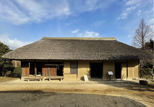
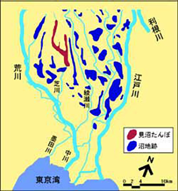
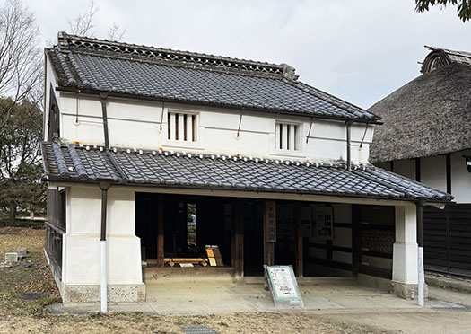
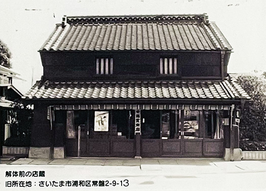
旧蓮見家住宅はさいたま市緑区井沼方、大宮台地の南端部、見沼の低地から入り込む谷に突き出た舌状台地上に所在していた。1730年当時開拓された「見沼たんぼ」のなかに「蓮見新田」もある。この地域は幕府直轄領であり「村高」は66石という記録がある。この一家が生産する米は成人66人が1年間に消費する量に相当するという記載とのこと。
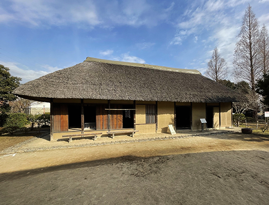
建物の建築年代を直接示すものはなく明らかではないが、構造手法から見て、江戸時代中期18世紀の前半、ちょうど1730年という年代時期に相当すると推定。そうすると約300年前となるか。桁行16.75メートル、梁間5.4メートルの寄棟造り、茅葺屋根の建物。たぶん新田開発を進めながらその農作業にも従事していた、その生産拠点としてやや高台の立地に建てられ、土地を管理していたのでしょう。関東のような平野部でも自然地形での高低差はあり、低地は水利を得やすく水田造営に適していたでしょうが、そのことは水害被害に遭いやすいということでもあり、居住家屋としては農地に適さない高台を選択したものでしょう。そういう土地利用は関東でよく見かける。
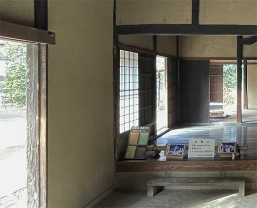
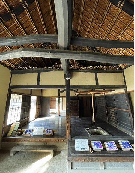
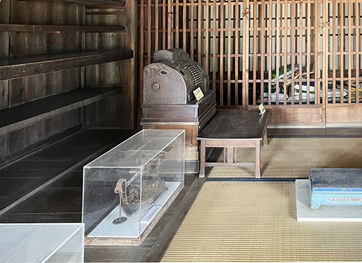
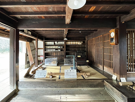
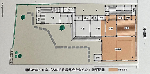
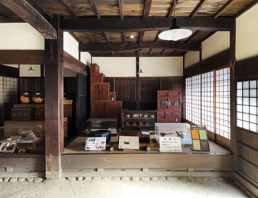
内部は向かって右に間口の半分以上の土間を取り、土間に沿って梁間いっぱいに板の間のヘヤ、その上手にオクと、その裏側にナンドを配している。いわゆる三室広間型の間取り。ヘヤには囲炉裏を設け、囲炉裏に接し土間側に板敷きの床を張り出していて、このヘヤ後方には戸棚を造りつけている。
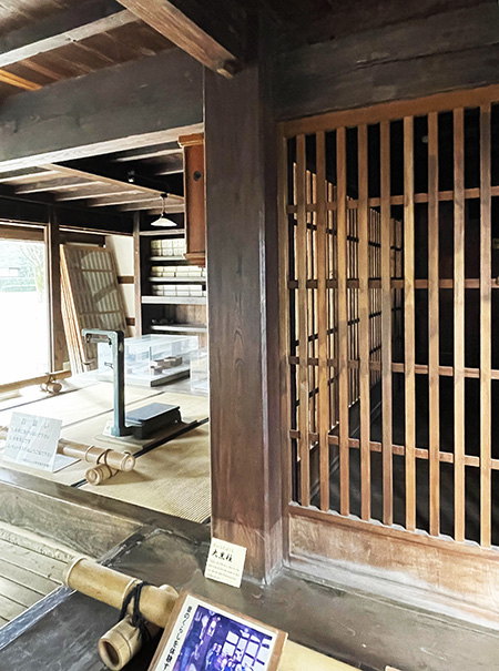
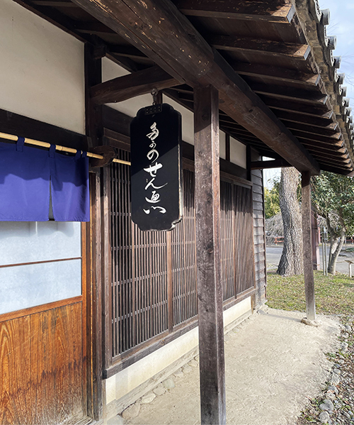
この建物の特徴として、南面するヘヤにはシシマド(格子窓)があること、柱は1間ごとに直接礎石の上に立つこと、大黒柱は細く杉材が使われている等があげられる。
シシマド・格子窓は「シシよけ窓」などと呼ばれており、イノシシやオオカミなどの獣の侵入を防ぐためのものだと言われて関東・中部地方に多く見られるという。逆に言うと家屋に対してそういった動物たちが進入を試みることがあったということ。
上の写真では外観の中央に格子窓がある。内観側の様子をあわせて見ていただきたい。内部側からはあんまり格子の存在は感じない。たんなる「明かり窓」のように思える。
やや高台の住居という条件では当然周囲は森に囲まれた環境になり、そういった獸たちが旺盛にテリトリーを作っていたのでしょう。現代北海道ではふたたびヒグマの害が増加してきているけれど、江戸期の関東開拓進行期でも、そういう用心が建築的にまで計られていた。いかにも「開発農家」的な雰囲気が色濃く感じられる。
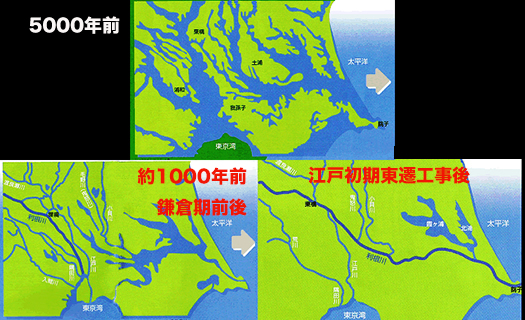
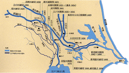
こういった関東での再開発が、明治以降北海道の「開拓農家」への民族的導火線になっていったというようにも類推が働いてくる。利根川東遷などの大規模自然改造・再開発が江戸期を通じて行われた、そういう意味では関東は「新開地」そのものだったのか。家康に捧げられた「東照大権現」という名前の意味があらためて興味深く想起される。

English version⬇

The God of Kanto’s Redevelopment, Tosateru Daigongen? Development farmers in Urawa-3
The “Shishimado,” a lattice window and a defensive device against wild boars and wolves, tells the story of the “newly developed land. Is the precedent of Hokkaido development the Kanto redevelopment? …

The former Hasumi family residence was located in Inumakata, Midori-ku, Saitama City, on the southern edge of the Omiya Plateau, on a tongue-shaped plateau that juts out into the valley that enters from the Minuma lowlands. This area was under the direct control of the shogunate, and the “village height” was recorded as 66 koku. It is said that the amount of rice produced by a family is equivalent to the amount consumed by 66 adults in a year.
Although there is no direct evidence of the building’s construction date, it is estimated to be in the first half of the 18th century during the middle of the Edo period (1730), which would make it approximately 300 years old. That would make it approximately 300 years old. It is a hipped-roof building with a thatched roof, 16.75 meters long and 5.4 meters beam-to-beam. It was probably built on a slightly elevated site as a production center for the development of new rice paddies and farming activities, and was probably used to manage the land. Even in the plains of the Kanto region, there are differences in elevation in the natural topography, and while lowlands are probably more suitable for paddy field development due to the ease of obtaining water, this also means that they are more susceptible to flood damage, so they probably chose higher ground for their residences, which is not suitable for farming. Such land use is often seen in the Kanto region.
The interior has an earthen floor more than half the width of the frontage on the right, a heya (a wooden floor) between the beams along the earthen floor, an oku (a wooden floor) above the heya, and a nando (a wooden floor) behind the heya. The floor plan is what is called a “three-room, wide-room” type. The hearth is set in the hearth, and the earthen floor is covered with wooden planks.
The only tatami-matted oku has an alcove, a butsudan (Buddhist altar), and a cupboard for decoration in the tatami room.
Other features of this building include shishimado (lattice window) on the south-facing heya, pillars standing directly on the foundation stone every 1 ken, and the daikoku-bashira (main pillar) made of thin cedar wood.
Shishimado or lattice windows are called “shishimado-yado” (meaning “window to keep out wild boars and wolves”), and are said to be common in the Kanto and Chubu regions of Japan. Conversely, such animals sometimes attempted to enter the house.
In the photo above, there is a lattice window in the center of the exterior. Please take a look at the interior as well. From the interior, the latticework is not so obvious. It seems to be just a “light window.
The house is located on a slightly elevated plateau and is naturally surrounded by forest, so these animals must have been actively establishing their territory. Even in the Edo period (1603-1868), when the Kanto region was being pioneered, such precautions were taken even architecturally. The atmosphere of a “development farmer” is strongly felt.
It is analogous to the way that the redevelopment of the Kanto region became a national focal point for Hokkaido’s “pioneer farmers” after the Meiji period. In this sense, the Kanto region may have been a “newly developed land” itself. The meaning of the name “Tosateru Daigongen,” which was dedicated to Ieyasu, is once again interestingly recalled.

【江戸の首都建設と並行した新田開発 浦和の開発農家-2】


きのう家康による「利根川東遷」という関東開発の大土木公共事業について触れた。家康が信長と同盟関係を結ぶ時のエピソードとして信長が常識的に京大阪という中心地域、畿内方面に勢力を拡張する方針を示したのに対して、家康は武家勢力の伝統的志向として東国方面に向かっての勢力拡張を目指したと言われている。
当時の織田徳川関係での平和共存、同盟としては当然の方針だったと思うけれど、ある意味ホンネでもあった可能性がある。信長後継の秀吉政権として家康に関東移転を命じたときに従順に従ったのには、そういう要素が色濃くあったのではないかと推測できる。
「あんた関東好きなんでしょ?」「上様、その通りでござる」
領国経営という意味では、基本的な生産力を上げることが自分の勢力拡大の最大の機会。家康はそういう方面のテクノラートを積極的に引き立てている。この利根川東遷計画に伴う土地開発計画でこの大土木工事には代官頭・伊奈備前守忠次を始めとする伊奈一族が伝世、中心的な存在として任用され続けた。事業の継続性には江戸政権の命運も掛かっていたと思える。やがて利根川の東遷から、荒川の西遷という土木事業をも誘発して関東中部地域の地盤安定・新田開発などの事業が伸展していった。
歴史事実としてはどうしても政戦のことが主に注目されるけれど、派手な政治軍事の底流ではこうした地道な自然改造努力が支えていた側面が大きい。家康という人物からはこういった目配りに繊細な感覚が見える。


一般社団法人 東京建設業協会のHPに「江戸幕府 60年かけ瀬替え、開削の大規模治水事業」という記事があって詳細な記述が見られます。この公共事業が江戸の新都市開発にとっていかにキモであり、その事業の成功が現代に至る首都機能の中核になっていることがわかる。
そしてその大計画は長い時間を掛けて継続され、1700年代初期に至ってこの家の周辺、浦和近辺での新田開発「蓮見新田」を造営してそれを見下ろす舌状台地上に、この事業主体者として旧蓮見家は建設された。茅葺き寄棟造りで、さいたま市内で一番古い民家と考えられている。
去年より今年、そして来年はもっと広げたいと新田開発の様子を毎日確認しながら、農作業・土木作業に取り組んでいたに違いない。新田開発に必至で取り組んでいた1700年代前期の開発農家の暮らしようが伝わってくる
はるかな後世の現代人は関東地域というと基盤整備の進んだ以降の姿しか知らないけれど、北海道で言えばつい150年ほど前の最初期の開拓農家とも似通った空気感が漂っていることになる。そう考えると高々100年程度の時間相違しかない。日本史の身近さ。その当時から歳月の積層による空間の変化はあるだろうけれど、建物の端々にその当時の人びとの息づかいは残されている。
歴史の時間の掘り起こしと住宅の取材とが絡み合って、独特のよろこびを感じることができる。最近見た間宮林蔵さんの生家にも似た雰囲気とも言えるだろうか。

English version⬇

Development of New Rice Fields Parallel to the Construction of the Edo Capital: Development Farmers in Urawa-2
Major civil engineering work in Kanto is the fundamental stable foundation for the establishment of the Edo shogunate. A major civil engineering project to create an economic foundation to replace war civil engineering. The foundation of Ieyasu’s success. ・・・・.

Yesterday, I mentioned Ieyasu’s “Tone River eastward shift”, a major public engineering project for the development of the Kanto region. It is said that when Ieyasu formed an alliance with Nobunaga, Nobunaga’s policy was to expand his power in the central region of Kyoto-Osaka and the Kinai region, whereas Ieyasu’s policy was to expand his power toward the eastern part of the country, which was the traditional orientation of samurai power.
This was a natural policy for the peaceful coexistence and alliance between Oda and Tokugawa at that time, but it is possible that Ieyasu was also sincere in a sense. When Hideyoshi, the successor to Nobunaga, ordered Ieyasu to relocate to the Kanto region, I suspect that there was a strong element of this in Ieyasu’s obedience to the order.
You love Kanto, don’t you? “You are right, my liege, that I do.
In terms of managing a fiefdom, the greatest opportunity to expand one’s power is to increase the basic productive capacity. Ieyasu is actively promoting technorats in that direction. The Ina family, including Ina Bizen no Tadatsugu, the head deputy magistrate, continued to be appointed as a central figure in this major land development project for the Tone River eastward shift project. It seems that the fate of the Edo administration also depended on the continuity of the project. Eventually, the eastward shift of the Tone River triggered the westward shift of the Arakawa River, which led to civil engineering projects to stabilize the ground in the central Kanto region and to the development of new rice paddies.
Although the political battles are the main focus of historical attention, the underlying political and military activities were largely supported by these steady efforts to improve the nature of the region. Ieyasu shows a delicate sense of attentiveness to such matters.

The Tokyo Construction Contractors Association website has an article “Edo Shogunate Spent 60 Years Replacing Segai and Opening the Sea for Major Flood Control Projects” with a detailed description. The article, “The Edo Shogunate Spent 60 Years Changing Segae and Opening the Sea,” provides a detailed description. It shows how this public works project was the key to the development of the new city of Edo, and how the success of the project has become the core of the capital’s functions to the present day.
The great plan was continued over a long period of time, and by the early 1700s, the old Hasumi House was built on a tongue-and-groove plateau overlooking the new rice paddy development “Hasumi Shinden” in the vicinity of this house, Urawa, as the main entity of this project. The house is a thatched hipped roof structure and is considered the oldest private house in Saitama City.
They must have been engaged in farming and civil engineering work, checking daily on the development of new rice paddies, hoping to expand the area this year and next year more than last. This photo conveys the way of life of farmers in the early 1700s, when they were working hard to develop new rice paddies.
Although people of today’s generation only know of the Kanto region as it has appeared since the development of the infrastructure, the atmosphere in Hokkaido is similar to that of the earliest pioneer farmers of Hokkaido, only 150 years ago. In that sense, the difference in time is only about 100 years at most. The familiarity of Japanese history. Although the space may have changed over the years, the buildings still retain the breath of the people of that time.
The intertwining of the excavation of historical time and the coverage of the houses gives me a unique sense of pleasure. The atmosphere is similar to that of Ino Tadataka’s birthplace, which I saw recently.

【縄文海進と家康の「関東大改造」 浦和の開発農家-1】


商家2軒をひもといてみた浦和の「民家園」保存建物の続篇。今回は地域の開発農家住宅篇です。関東を家康が治めるに際してかれは大規模な自然改造計画を打ち出している。上の外観写真の下は今回の住宅に関連する「見沼たんぼ」を赤く図示した広域図、そして巨大自然改造計画「利根川東遷」の図。
関東平野というのは日本最大の平野部でありながら、縄文海進の名残が強く残っていて整合的な河川構成ではなく、最大の暴れ川・利根川が江戸湾(東京湾)に注いでいて中心地域・江戸ですら安定した地面の確保が難しい広大な地域。巨大な湿潤平野地域が生む「坂東太郎」という巨大雲の造形が作られる。
そういう地域だけれど、武家権力にとっては鎌倉期以来の「本願」の地。ヤマト王権が比較的に安定した地盤面と気候風土の「畿内」地域を基盤として成立したのにはそういう背景事情があったと思うし、東国・関東をどう安定支配するかが日本の権力の歴史的「課題」でもあったのだろう。
そういう地域の支配権を秀吉は家康に与えた。基本的には関東に「封じ込めた」のだろう。安定した領土・東海5カ国を取り上げて関八州と交換させた。「これでオレの権力はひと安心だ」と思ったに違いない。そういう不利な領土移転に対して地道な領土経営を家康は坦々と進める。
家康の天下取りは、かれの「治政・治山治水能力」に依るところが大きいのではないかと思っています。なんといってもその最たるものは関東での利根川の東遷計画の遂行でしょう。
いまは「どうする家康」の度肝を抜くファンタジーぶりが話題になっていますが、かれの能力は三河・遠江・駿河の3カ国支配から信長の死を経てあっという間に甲斐・信州を併合した統治能力と、その後の秀吉による関東移封を見事に逆手にとって、関東に平和と政治体制の安定をもたらした手腕に依るところが大きい。武田氏や北条氏の遺臣たちがあっという間に家康に従ったことが、すなわち人心と地域の安定をもたらし、それがかれの天下制覇に繋がったのだと思うのです。
ぜひそのような非ドラマチックなテーマをたっぷりと見せ場にすることを期待したい(笑)。でもまぁ、そういうのはムリでしょうね。たぶん信長や秀吉のような重商主義変革路線に対して、農本主義的な支配体制路線が対置されるのでしょう、常識的に。
で、戦国期に盛り上がった「築城土木技術」が、家康によってこの利根川東遷計画という驚嘆すべき平和的な河川土木工事・建築工事に昇華させられたことが、かれ家康の隠れた「革命性」だったように思われるのです。さてどうでしょうか?
こういう自然大改造計画というのは日本史上でも稀有。鎌倉武士以来、辛苦を重ねてきた関東支配が実質的に完成した巨大事業。いなほの国・日本の政治権力の正統性は、やはり自然をしっかりコントロールする能力に淵源を持つのだと思う。日本全体にとって次の民族的領土経営課題は北海道に受け継がれる。
紹介する「旧・蓮見家住宅」は、この家康の大土木事業に関連した自然改造の結果、新規造成された田園の新興地主農家住宅という性格が強い。前段の地域開発側面の把握に沿って明日以降に続けます。

English version⬇

Jomon sea advance and Ieyasu’s “Great Kanto Reform” Development Farmers in Urawa-1
Public works projects to remodel nature from the viewpoint of “management” rather than “domination”. The basis of this project, the Tone River eastward shift project, is a gigantic flood control project. The “Tosateru Daigongen,” the sovereign of God. The “Tosetsu Daigongen” character, the divine sovereign.

A continuation of the “Minka-en” preserved buildings in Urawa, where we looked into two merchant houses. This time, we will look at the development of farmhouses in the area. When Ieyasu Ieyasu ruled the Kanto region, he launched a large-scale natural remodeling project. Below the exterior photo above is a red map of the “Minuma-tambo” area related to the houses in this issue, and a map of the “Tone River Eastward Transition,” a massive natural remodeling project.
The Kanto Plain is the largest plain in Japan, but it is a vast area where the remnants of the Jomon sea advance remain strong and the river configuration is not consistent, and the largest river, the Tone River, flows into the Edo Bay (Tokyo Bay), making it difficult to secure stable ground even in the central area, Edo. The huge humid plain area creates a huge cloud formation called “Bando Taro.
Although it is such an area, it has been the land of “Hongan” for the samurai power since the Kamakura period (1185-1333). I believe that this was the background for the establishment of the Yamato kingdom based on the relatively stable ground and climate of the Kinai region, and that the stable control of the eastern provinces and the Kanto region was also a historical “issue” for the Japanese power.
Hideyoshi gave Ieyasu the right to control such areas. Basically, he “contained” them in the Kanto region. He took away the five stable territories of the East Sea and exchanged them for the eight provinces of Sekihachishu. He must have thought, “Now my power is secure. Ieyasu’s steady territorial management in the face of such unfavorable territorial transfers proceeded smoothly.
I believe that Ieyasu’s success in the country was largely due to his “ability to govern and control mountains and floods. The most important of these was his plan to shift the Tone River eastward in the Kanto region.
Although “What to do about Ieyasu” is currently the talk of the town for its mind-boggling fantasy, Ieyasu’s ability to govern is largely due to his ability to rule the three provinces of Mikawa, Omi, and Suruga, and then, after Nobunaga’s death, to annex Kai and Shinshu in a flash, and to his skill in taking advantage of Hideyoshi’s subsequent move to Kanto, bringing peace and political stability to the region. The success of the shogunate was largely due to its ability to bring peace and political stability to the Kanto region. The fact that the vassals of the Takeda and Hojo clans quickly followed Ieyasu’s lead, in other words, brought stability to the region and to the hearts of the people, and I believe that this is what led to Ieyasu’s conquest of the region.
I would love to see you showcase such a non-dramatic theme in your film (laugh). But, well, such a thing would be impossible. Perhaps the heavy mercantilist reformist line of Nobunaga and Hideyoshi would be opposed to the nouveau riche ruling system line, as common sense would dictate.
The fact that Ieyasu sublimated the “castle-building civil engineering technology” that flourished during the Warring States period into the marvelous and peaceful river engineering and construction work known as the Tone River Eastward Expansion Project seems to have been Ieyasu’s hidden “revolutionary” nature. What do you think?
This kind of major natural remodeling project is rare in the history of Japan. It was a gigantic project that practically completed the rule of the Kanto region, which had been painstakingly ruled since the time of the Kamakura samurai. I believe that the legitimacy of the political power of Japan, the Land of Inaho, has its origin in the ability to firmly control nature. For Japan as a whole, the next national territorial management issue led to the management of Hokkaido.
The “Former Hasumi Family Residence” introduced here is a newly created rural farmhouse of the Hasumi family, which was the result of the natural remodeling related to Ieyasu’s major land development project. We will continue tomorrow and beyond in line with the understanding of the regional development aspect of the previous section.

【農本主義から資本主義へ社会転換 中山道・浦和宿の町家-9】


江戸期というのは本来海洋国家であった日本が貿易による海外発展を制限して、国内治安優先で作り上げた社会だった。そのなかで経済は土地執着性の強い武家の価値感が主体的で、基本的にコメ生産中心の考え方で各藩毎の経済規模を、万石単位というコメ生産基準で定めていた社会。
しかし、コメ生産は江戸幕府体制が確立して100年後ほどの1700年前後には総人口3,000万人に対してほぼ調和する3,000万石生産が達成されて、その後は幕末までそのコメ生産規模が安定して推移したとされる。人口1人あたり年間消費は1石というのが単位の計算基準。
で、基本になるコメ生産は増えずに一定に定まってくると、それ以外の商品作物に農地を利用するようになるのが自然の成り行き。そういったなかで、開明的な藩などが大阪の全国流通市場を睨んで積極的に全国規模での「名産」づくりに取り組んでいった。江戸中期以降、コメ生産以上にこうした商品作物の多様化が進展した。日本各地の文化的多様性はこのことが裏付け。
社会固定的な米一本足経済から、社会全体の経済発展の結果、多様な商品作物が経済の中心領域に推移していったということだろう。多様な商品作物毎に最適化された肥料を選別的に商う商家というビジネスが成立するほどになっていったのだろう。幕末期に開国に舵を切っていく政治変動はこうした経済発展の必然だったともいえるのだろう。
わたしの生家、父は戦後期には北海道の商品作物産品を買い付けて大阪の市場に対して送るビジネスを行っていた。小作解放によって得られた自作農の地位だけでなく、いわば商品作物流通、それも全国規模での市場構造に着目して、投機的なビジネスを行っていたというのです。
一時期は親の代から根付いた北海道栗沢を中心とした地域で「ユリ根」を集中生産して大阪まで送りつけて利を得ようとした。けれど、商品市場では「暴落」という事態もまま発生する。貨車を仕立てて大阪まで全財産を賭けてユリ根を大量に送ってから至急電報で「大阪の市場価格暴落!」の知らせが入って、急遽、貨車を新潟で停止させて、それをまだ暴落していなかった関東に送ることで危機を免れたという。
あまりにも投機的な危険性に深く気付いて、その後、札幌での食品製造業に進出していくきっかけだったと父のコトバで聞いたことがある。
街道筋の商家という共通性のある浦和の古建築をみることで、江戸から今日に至る農本主義から資本主義経済への転換期の民衆の生活史を具体的にみることができたように思う。そのままわが家の家系の推移もシンクロさせてみていた。非常に生々しい記憶なども再生されてきてしまった。
北海道内の住宅史推移なども見てきていたけれど、むしろこういった商家の生業感のほうが自分的にはよりリアリティがあり、取材の観点でもより奥行きを感じさせられる。

English version⬇

Social Transformation from Farmerism to Capitalism: Machiya in Urawa-juku, Nakasendo – 9
A major social transformation to a commodity distribution economy in a concentrated city. This group of merchant houses visualizes the transformation from the Edo period to the present day. …

During the Edo period, Japan, originally a maritime nation, restricted overseas development through trade and created a society that prioritized domestic security. In this society, the economy was based on the values of the samurai clans, which were strongly attached to the land, and the economic scale of each clan was basically based on rice production, which was defined by the rice production standard of 10,000 goku.
However, around 1700, about 100 years after the establishment of the Edo shogunate, rice production reached 30 million koku, which was in harmony with the total population of 30 million, and remained stable until the end of the Edo period. The standard for calculating the unit is that each person in the population consumes one stone of rice per year.
When rice production, which is the basis of the unit, was fixed at a certain level without increasing, it was natural to think of using farmland for other commodity crops. In such a situation, open-minded clans and others actively worked to produce “specialty products” on a national scale, with an eye on the nationwide distribution market in Osaka. From the mid-Edo period onward, the diversification of such commodity crops progressed beyond rice production.
This may be the result of the economic development of society as a whole, which has shifted from a fixed, single-footed rice economy to one in which a variety of commodity crops are at the center of the economy. The business of merchants who selectively traded fertilizers optimized for each of the various commodity crops may have been established. The political changes that led to the opening of Japan to the outside world at the end of the Edo period can be seen as an inevitable consequence of this economic development.
In the postwar period, my father’s family was engaged in the business of buying commodity crops from Hokkaido and sending them to the Osaka market. He was engaged in a speculative business, focusing not only on the status of tenant farmers, which had been gained through the liberation of smallholdings, but also on the distribution of commodity crops, so to speak, and the structure of the market on a national scale.
For a time, he tried to gain profit by producing “lily root” intensively in the area centering on Kurisawa, Hokkaido, where it had taken root since his parents’ generation, and sending it to Osaka. However, the commodity market was prone to “crash prices. After sending a large quantity of lily bulb to Osaka with all his money, he received a telegram immediately saying, “The market price of lily bulb in Osaka has plummeted! The company was able to avoid the crisis by stopping the wagons in Niigata and sending them to the Kanto region, where the market had not yet plummeted.
I have heard my father say that this was the beginning of his later foray into the food manufacturing business in Sapporo, as he was deeply aware of the dangers of being too speculative.
By looking at the old architecture of Urawa, which has the commonality of being a merchant house on a street, I think I was able to see in concrete terms the history of the people’s lives during the transition from an agrarian to a capitalist economy from the Edo period to today. I was also able to synchronize the transition of my family’s history. I was able to replay some very vivid memories.
Although I have seen the history of housing in Hokkaido, I feel that this kind of business of a merchant family is more realistic and gives me a greater sense of depth from the perspective of the research.

【商品作物経済の基幹「肥料」 中山道・浦和宿の町家-8】


江戸期には京都で旺盛に盛り上がった呉服産業があり、綿の生産には大量の魚肥が必要とされて、その需要が蝦夷地のニシン漁の漁獲・運送を盛んにさせたことが知られる。高田屋嘉兵衛という事業者の成功には、京阪神地域での産業革命、ビジネス革命があったことが偲ばれる。社会が沸騰するような農産物の多様化・産業化が進んだのでしょう。
呉服産業というのはまったくのファッション産業だけれど、江戸期の社会発展はそういう産業基盤条件を形成していったということ。幕府が繰り返し「贅沢禁止令」みたいなものを発出した背景にはそういった社会発展に伴う強い需要があったと言われる。
また幕末期以降には横浜の開港、海外貿易の開始という経済的インパクトが起こって、とくに関東一円では「養蚕」業が旺盛に発展した。その蚕のためのクワの生産が空前の需要を生んでいった。
そうした商品作物の生産競争の中で、単位面積あたりの収量を左右する「肥料」に農家経済は依存を深めていった事情が垣間見える。肥料屋さんという商売が大きく成立した背景には、江戸期以降からの多様な商品作物の生産の盛り上がりが大きい。日本資本主義の勃興期そのものだろうか。とくに消費都市大都会・江戸の需要に応える意味合いがこの浦和宿ではきわめて大きかったのでしょう。浦和周辺地域からの江戸・東京への商品作物出荷も盛んだったことだろう。
上の写真は浦和の町家のなかでも広い間口を開いているこの店舗のようす。江戸期・明治大正戦前期には大八車などで「肥料」搬出入が繰り返された。運搬動力としては基本的には馬が使われたのでしょう。3枚目の写真は昭和30年代の店舗の写真だそうですが、よくみると店の前に「オート三輪」とおぼしきトラック車両が横付けされて肥料が積み出されている。
買い付けに訪れる農家や「仲買人」たちがこの肥料店で購入して、店舗奥側のバックヤードから運び出された商品がこの店先から出荷されていった状況なのだろう。
明治以降、開拓が進展した北海道札幌でも、よく似た光景が展開していて、幹線道路「石山道路」に面していたわたしの生家前には運搬に使役された馬たちの「馬糞風」が吹いていた。そして運搬動力はこの写真のようにオート三輪が活躍した。たぶん似た光景がこの浦和宿でも見られていたに違いない。自分自身が体験した幼年期の記憶がシンクロしてくる。


店舗内の風景としては「量り売り」のための計量器がドンと鎮座している。大量取引の場合はこうした計量器が使用され、より小口取引の場合には、マスでの販売が行われたというような説明が行われていた。まことに画期ある商取引の状況が活写されている。
昨日よりも今日、そしてあしたはもっと良くなるということを多くの人びとが信じていた。

English version⬇

Fertilizer, the backbone of the commodity crop economy.
The air is filled with the vitality of the contact point of the commodity crop economy, the active buying, selling, and transporting of fertilizers. The breath of a manufacturing society. The breath of a manufacturing society.

It is known that the kimono industry flourished in Kyoto during the Edo period, and that the production of cotton required large amounts of fish manure, the demand for which stimulated the fishing and transportation of herring in the Ezo region. The success of an entrepreneur named Takataya Kahei is remembered for the industrial and business revolution in the Kyoto-Osaka-Kobe region. It must have been the diversification and industrialization of agricultural products that brought society to a boiling point.
The kimono industry is a totally fashionable industry, but the social development during the Edo period formed such industrial base conditions. It is said that there was a strong demand for such products due to social development, which was the reason why the shogunate repeatedly issued a kind of “luxury prohibition.
In addition, after the end of the Edo period, the opening of the port of Yokohama and the start of overseas trade had an economic impact, and the “sericulture” industry developed vigorously, especially in the Kanto area. The production of mulberry for silkworms created unprecedented demand.
In the midst of such competition in the production of commodity crops, the farm economy became increasingly dependent on “fertilizers,” which were crucial to the yield per unit area. The background to the establishment of the fertilizer business is largely due to the rise in the production of various commodity crops since the Edo period. Was this the very period of the rise of Japanese capitalism? In particular, the Urawa-juku must have been extremely significant in meeting the demands of the consumer metropolis of Edo. The shipment of commodities from the Urawa area to Edo and Tokyo must have been very active.
The photo above shows a store with a wide frontage among the town houses in Urawa. During the Edo period and the Meiji-Taisho prewar period, “fertilizer” was repeatedly carried in and out of Urawa by large carts and other vehicles. The third photo is said to be a photo of the store from the 1950s, and if you look closely, you can see a truck vehicle that looks like an “auto three-wheeler” parked in front of the store, and fertilizers are being loaded out.
It is likely that farmers and “middlemen” visiting the store to buy fertilizers purchased the products at this store, and the products were shipped out from the back yard at the rear of the store.
In Sapporo, Hokkaido, where pioneer settlers developed after the Meiji period, a similar scene was often seen, with the “horse dung wind” of horses used for transportation blowing in front of my birthplace, which faced the Ishiyama Road, a main road. As you can see in the photo, three-wheeled motorcycles were used for transportation. A similar scene must have been seen at the Urawa Inn. My own childhood memories of the Urawa Inn are synchronized with this scene.

As a view inside the store, a weighing scale for “weighing and selling” is sitting on the floor. The explanation was that such a scale was used for large volume transactions, while mass sales were used for smaller transactions. This is truly a vivid picture of business transactions in an epoch-making period.
Many people believed that today and tomorrow would be better than yesterday.

【伝統的「塗屋造」で大火に耐える 中山道・浦和宿の町家-7】


写真は浦和の町家、旧・綿貫家の壁面の構造と外観。外観からは通りに面した開口部でもていねいに木部が土壁で「塗り籠められて」いる。建物外部の柱や窓枠などを大壁造として白壁で塗り籠む建築様式。内部からは柱が見えるが、外部からは柱や窓の木部が見えない。
明治22年の浦和の大火にもこの家は無事に残った。現在は移築保存されていて、忠実に解体前の造作が復元されているけれど、移築前の外観写真では白壁ではなく、全体として「黒塗り」のような印象。

これはこの明治の大火のときに、周辺からの火焔に燻された結果のようだ。「塗屋造」は近世以降の町家によく用いられ、耐火建築としての効用からつくられた。一般に町家では側面は1、2階とも塗り籠められるが、正面と背面の一階部分は軒裏の垂木(たるき)や桁(けた)などが塗り籠められるのみで、柱や格子はそのまま木材部分を現し、腰回りの蹴(け)込み部分も木を残している。
ただ塗屋造といっても、すべてを塗り籠めるわけではなく、なかには背面の軒裏を省略するもの、また二階の壁体部分を塗り籠めるだけで、正面・背面とも軒裏は塗り籠めないものなど、簡略化したものもある。この綿貫家では解体前も移築後も正面の柱まで塗装仕上げされている。かなり念入りな防火への備え。
こういう塗屋造りの問題点はなんと言っても工事価格が高いこと。江戸期の大工仕事でどれほどだったかは、資料に乏しいけれど、塗り壁はすべて手作りなので手間がかかりどうしても工期が長くなる。そのため、人件費がかかり材料によっては価格が高くなってしまうデメリットがある。

そこでふと気付いたのが、この綿貫家では肥料などの商い、それも大口需要に対してのビジネスが主体であったと言うこと。店舗内には厳重な耐火金庫が見られ、その風貌・印象共に「証文」などの超一級ビジネス文書が厳重管理されていた様子をうかがわせている。こころなしか、この金庫、たしかに大火をも生き延びたような風格を淡々と物語っているように感じさせられる。
「○○屋さん、お宅との商取引の証文、無事でしたよ(笑)」
「おお、それはよかったですね(ゲ、マジかよ,しぶといヤツだなぁ)」
土蔵造りなどの建物が大火を生き延びた様子の大和絵などは風俗画として残されているけれど、日本の商業の発展にとって繰り返された都市火災を生き延びることは、必要要件だったことだろう。とくに火災に繰り返し襲われ続けた町人主体の街、江戸の近隣都市商家として生き延びる必須要件だったと思う。
解体前のこの商家のたたずまいから、日本の資本主義の生々流転を感じる次第。最近はデジタル化が進んで取引でも、こういう目に見える建築文化要素が消えてゆくだろうか。さて。

English version⬇

Traditional “Nuriya-zukuri” style townhouse in Urawa-juku, Nakasendo district, withstood a large fire.
The rise and fall of commerce due to repeated “big fires” in Japan, a cultural sphere of wooden architecture. The wisdom of architectural fire prevention to fight against crisis. Protect the business certificate! ・・・・・.

The photo shows the wall structure and exterior of the former Watanuki house, a townhouse in Urawa. From the exterior, even the openings facing the street are carefully “painted” with clay walls. The exterior columns and window frames are painted with white walls in a large wall construction style. The pillars can be seen from the inside, but the wood of the pillars and windows cannot be seen from the outside.
The house survived the Great Urawa Fire of 1889. The house has been relocated and preserved, and the original structure has been faithfully restored to its original state.

This seems to be the result of being smoked by flames from the surrounding area during the Great Fire of the Meiji Era. The “nuriya-zukuri” style was often used in machiya (townhouses) from the early modern period onward, and was created for its utility as a fireproof building. In general, the sides of machiya houses are painted on both the first and second floors, but only the rafters and girders behind the eaves are painted on the front and rear ground floors, leaving the pillars and latticework as they are and the wooden parts around the hips.
Some of them omit the eaves lining on the back, while others only paint the walls of the second floor, but not the eaves lining on both the front and the back. In the Watanuki house, the front pillars were painted both before and after demolition and reconstruction. This is a very careful preparation for fire prevention.
The problem with this type of nuriya-zukuri is the high cost of construction. Although there is little information available on how much carpentry work was done during the Edo period, the labor required to paint walls is all handmade, which inevitably lengthens the construction period. Therefore, there is a disadvantage that the cost of labor and some materials are more expensive than others.

Then, I suddenly realized that the Watanuki family was mainly engaged in the fertilizer business, which was a business for large orders. Inside the store, there is a fireproof safe, and its appearance and impression suggest that top-class business documents such as “certificates” were kept under strict control. Perhaps it is because of its appearance, but the safe seems to have survived the great fire.
The safe was in the safe.
“Oh, I’m glad to hear that.
Yamato-e paintings depicting how buildings in the dozo-zukuri style survived large fires have been preserved as genre paintings, but surviving repeated urban fires must have been a necessary condition for the development of commerce in Japan. In particular, I believe it was a prerequisite for the survival of merchant houses in the neighborhoods of Edo, a city where townspeople were the main residents, to survive fires that repeatedly ravaged the city.
The appearance of this merchant house before its demolition reminds me of the life and death of Japanese capitalism. I wonder if these visible elements of architectural culture will disappear in the course of trade with the advance of digitalization these days. Now, let’s see what happens next.

【宿場町と市場経済 中山道・浦和宿の町家-6】


この浦和宿の荒物(雑貨)肥料店舗・旧綿貫家は、江戸時代後期には確実に浦和で商家を営んでいた。1844年当時に描かれた「宿並絵図」に記録が残されている。周辺環境は農業が主体の地域だから、比較的に需要の多い店舗だったのだろうと推測できる。
荒物とはザルやホウキ、チリトリなどの雑貨が主体。一方の肥料店はメインの肥料をはじめ砂糖・小麦などの仲卸と大口客相手の取引を営んでいたのだという。肥料にもそれぞれの作物毎に最適化された品種が存在して売買されていたことがわかる。
さらに浦和宿には、大名の参勤交代の旅宿があったとされている。東北地方・関東北部の大名家が行列を組んで大名自身は「本陣」と言われるメイン旅宿に泊まり、その他の随行員たちは「脇本陣」と呼ばれる旅宿に泊まった。この浦和宿の本陣は「星野権兵衛家」という家系が代々取り仕切っていたという。本陣敷地は約4000㎡(約1200坪)、主屋は700㎡(212坪)という広大な面積を誇っていたとされる。この建物は現在現存せず、その敷地跡には明治天皇がさいたま市の氷川神社行幸の折に立ち寄った記念碑が建てられている。江戸期の宿場町経済の実態を伝えているようです。
わが家の家系伝承では先祖たちは広島県福山市の山陽道・今津宿で、国造以来の家柄の名家「河本家」が営んでいた「今津本陣」とのビジネスで「英賀屋」という屋号で商家を営んでいた。江戸期の経済実態とは、こうした宿場町経済が地方においては中核的なビジネスだったのだとわかる。
肥前平戸の9代藩主・松浦静山が描いた「甲子夜話」に、宿泊した「今津本陣」での旅宿側の勤労奉仕ぶりが描かれているなかにわたしの先祖の動静も記されています。参勤交代という社会システムが地域経済にとってどういうものだったのかがよくわかる。江戸期の商業にとっていかに巨大機会であったことか。
そうした中核的なビジネスがあってさらに周辺的な商品・サービスが宿場町には集中していたのだろう。たまたま同様の宿場町の様子が保存移築されている浦和宿の様子から、わが家のことまでまざまざと先人の息づかいが皮膚感覚で伝わってくるような思いがする。


ということから若干スピンアウトして、昭和30年代(1958年)当時、札幌市中央区北3条西11丁目で食品製造業を生業としていた当時のわが家の古い写真です。先日、浦和宿の煎餅屋さんの生業の様子を見たけれど、よく似たような写真で、若かった父親が中央で生産現場を見ている様子。食品製造の最終工程なのですが、その視線には先日の煎餅屋さんのご主人とおぼしき方と似た必死さが表れている。
江戸期から昭和30年代というスパンで見ても、日本人の経済の営みは連綿と受け継がれてきている感覚・同一感がある。180年前後の時間空間が通底してくるのですね。歴史時間の重量感。

English version⬇

The Postal Town and Market Economy: Townhouses in Urawa-juku on the Nakasendo Highway – 6
The actual situation of the economy of the inn town in the Edo period can be seen like a perspective drawing. The time of 180 years before and after the Edo period and the breath of the predecessors come together in one span of time. The house is a townhouse.

The former Watanuki family, which operated a fertilizer store in Urawa-juku, was certainly a merchant in Urawa in the late Edo period (1603-1868), as recorded in “Shukuninami Ezu” drawn in 1844. Since the surrounding environment is primarily agricultural, it can be assumed that the stores were in relatively high demand.
Rough goods are mainly miscellaneous goods such as colanders, brooms, and dust trimmers. The fertilizer store, on the other hand, was a wholesaler of fertilizers, sugar, wheat, and other commodities, and also dealt with large customers. It is evident that fertilizers were sold and traded in varieties optimized for each crop.
Furthermore, it is said that Urawa-juku was also a traveling inn for daimyo daimyo’s daimyo’s visits to the area. Daimyo families from the Tohoku region and the northern part of Kanto formed a procession, and the daimyo themselves stayed at the main traveling inn called “Honjin,” while the other attendants stayed at the “Wakihonjin,” or side inn. The main camp at Urawa-juku was managed by a family called “Hoshino Gonpei Family” for generations. The main camp site was approximately 4,000 square meters (about 1,200 tsubo), and the main building boasted a vast area of 700 square meters (212 tsubo). The building no longer exists, and a monument stands on the site where the Emperor Meiji stopped by during his visit to Hikawa Shrine in Saitama City. It seems to convey the reality of the inn town economy during the Edo period.
According to our family tradition, our ancestors ran a merchant house under the trade name of “Eigaya” in Imazujuku on the Sanyo Road in Fukuyama City, Hiroshima Prefecture, in business with the Imazu Honjin, which was run by the Kawamoto family, a prominent family since the Kokuzo period. The economic reality of the Edo period shows that this kind of lodging town economy was a core business in the local region.
In the “Koshi Yawa (Tales of Koshi)” written by Shizan Matsuura, the ninth lord of Hirado, Hizen Hirado, the movements of my ancestors are described in the description of the labor service of the innkeepers at the “Imazu Honjin” where the innkeepers stayed. It is easy to see how the social system of “Kan-kodogodai” (pilgrimage to and from work) was important to the local economy. It is clear what a huge opportunity it was for commerce in the Edo period.
With such core businesses in place, there must have been a concentration of peripheral goods and services in the inn towns. The Urawa-juku, which happens to be a preserved and reconstructed example of a similar inn town, gives me the feeling that I can feel the breath of my predecessors in my own home.

So, spinning out slightly from this, here is an old photo of our house at the time of the 1950s (1958), when we were making a living as a food manufacturing business in Kita 3-jo Nishi 11-chome, Chuo-ku, Sapporo. The other day, I saw a picture of a cracker shop in Urawa-juku, which was a very similar picture, but the father, who was young, is in the center watching the production site. It is the final process of food production, and his gaze shows a desperation similar to that of the owner of the senbei shop the other day.
The time-space of around 180 years is at the bottom of the story. The weight of historical time.

【用を満たす店舗群「荒物肥料屋」 中山道・浦和宿の町家-5】


日本の街道というのは、経済発展の基盤としての流通の大動脈。律令制国家システムが本格的に導入された奈良の首都建設で大陸国家・唐の都市計画を導入したときに本格的に「官道」が整備されたと伝わる。律令制時代に、中央と地方国府とを結ぶための幹線道路として整備された大型直線道路(五畿七道)などを指す。五畿七道とは、古代日本の律令制における広域地方行政区画。明治になって北海道が加わって五畿八道と呼ばれる。現在の日本各地の地方名の多く(東海、東山、北陸、山陽、山陰、北海道など)は、五畿七道(八道)に由来している。
余談ながらこうした官道整備と並行して輸送手段としての馬が輸入されていった歴史が重なる。列島には馬は自然的には存在せず、こうした官道・街道整備と一体のモノとして馬の輸入・生産も広がっていった。流通を起点とした古代社会での「技術革新」の実態を見る思いがしてくる。
ただ日本は海洋国家であり、物流では伝統的に水運が主力だったことで社会発展に於いて世界の中でも独自の進化をもたらしたように思える。海運・水運が大量輸送の主力であり大都市はそれらの港湾が基盤となり、一方陸路の要衝地というのはより農業を基盤とした流通路として発展したのだろう。この中山道・浦和宿は他の地域とは異なって全部が陸路という独自性がある。浦和宿は戦国時代に発生した「市」が発祥だと考えられている。それが江戸期に整備された中山道の宿場町として発展した。1844年当時で上町96軒、中町47軒、下町69軒の合計212店の商店の記録がある。旅籠・穀屋・水油屋・飲食店・建具屋・道具屋など多様な店舗群。
この浦和宿の2軒目の住居一体型の生業町家建築は「荒物・肥料」屋さん綿貫家であります。


中山道の旅客や周辺地域の人びとのさまざまな生活必需品などが商われたことだろう。旅籠・飲食店などを中心にして「歓楽」的要素も大きな吸引力を持って暮らしに彩りをもたらせたに違いない。そしてそうした交流の中から情報も伝達されていった。それもまた地域の人びとにとって生きる支えになったことだろう。周辺の農村的環境とは隔絶した「キラキラ」した地域存在としてあり続けたことだろう。
いわゆる住宅という「住むだけ」機能よりもより人間性の本質を刺激するのがこうした街区環境といえるだろう。どうもこのあたりの人間性の本然の部分が気になってきて仕方ない(笑)。
中山道を中心に裏通りまでの短冊形の地割りであり、建物の間隔1mほどの道があってそれに沿って店舗・蔵・物置・住居棟などが配置されている。綿貫家も間口4間を西に向けた配置図になっている。
前振りが長くなったので、店舗と建築については明日以降に続きます。

English version⬇

A group of stores that fulfill the needs of “Aramono Fertilizer Store” Machiya in Urawa-juku, Nakasendo – 5
The transportation network originating from “government roads” that brought “industry” to the archipelago. The exchange of people, goods, and money stimulates social evolution and the true nature of humanity. The “Nakayamamichi Urawa-juku” townhouses

Kaido in Japan is a major artery of distribution as a foundation for economic development. It is said that “official roads” were developed in earnest when the Ritsuryo system of state system was introduced in earnest when the city planning of the continental state Tang Dynasty was introduced with the construction of the capital city of Nara. The term refers to the large straight roads (Gokyo seven roads) and other roads that were developed during the Ritsuryo period as trunk roads to connect the central government with the local national governments. The Gokyo-Seventh Province was a broad regional administrative division under the Ritsuryo system of ancient Japan. In the Meiji era (1868-1912), Hokkaido was added to the list and the region was called the Ginki Hachimichi (Five Kinai and Eight Provinces). Many of the current names of regions in Japan (Tokai, Higashiyama, Hokuriku, Sanyo, San’in, Hokkaido, etc.) are derived from the Ginki seven provinces (eight provinces).
As an aside, the history of the importation of horses as a means of transportation coincides with the development of these official roads. Horses did not exist naturally in the archipelago, and their importation and production spread as an integral part of the development of these official roads and highways. This is a realistic picture of “technological innovation” in ancient society, with distribution as its starting point.
However, Japan is a maritime nation, and water transportation has traditionally been the main form of distribution, which seems to have brought about a unique evolution in social development. Sea and water transportation were the mainstay of mass transportation, and large cities were based on these ports and harbors, while key locations on land routes developed as distribution routes based more on agriculture. Unlike other areas, Urawa-juku on the Nakasendo Road is unique in that it is entirely an overland route. Urawa-juku is thought to have originated as a “market” that arose during the Warring States Period. In 1844, there were a total of 212 stores (96 in the upper town, 47 in the middle town, and 69 in the lower town). This diverse group of stores included inns, grain stores, water oil stores, restaurants, fixture stores, and tool stores.
The second house in this Urawa-juku, a living machiya building with an integrated dwelling, is the Watanuki house, a “rough goods and fertilizer” shop.

Various daily necessities for passengers on the Nakasendo route and people living in the surrounding areas must have been traded. The “entertainment” element centering on inns, restaurants, and other such establishments must have attracted people to the area and added color to their lives. Information was also transmitted through such interactions. This must have been another source of support for the local people. The area must have continued to exist as a “sparkling” community that was separated from the surrounding rural environment.
It can be said that this kind of town environment stimulates the essence of humanity more than the “living only” function of housing. I can’t help but be curious about the true nature of humanity in this area (laughs).
The land is divided in the shape of a strip of land centering on Nakasendo Road to the back street. There is a road with a distance of about 1 meter between buildings, and stores, warehouses, storehouses, and residential buildings are arranged along it. The Watanuki family also has a layout with a frontage of 4 ken, facing west.
Since the introduction has become lengthy, we will continue with the store and the architecture tomorrow or later.

【町家の地割りと現代型住宅地 中山道・浦和の煎餅店-4】


浦和民家園」を探訪するシリーズ第4回目。このシリーズの第一回目はこちら→【関東の古民家探訪「中山道の高野煎餅店」-1】

街道筋に面した立地というのは多様な人びとの交易・交流を基本に置いた「地割り」。間口が狭く、奥行きが長い敷地形状が合理的な土地利用法となっている。「町家型土地計画」とでも呼べるのでしょう。
日本では京都の町家がひとつの典型とされるけれど、別に京都だけに特別なものではなく、全国どこの地域でも普遍的にこの考え方で街区が形成された。民族の最新大都市である札幌でも「狸小路」が自然に生成した。
間口を狭くすることでたくさんの商家が単位距離あたりで密集性が高まって原初的な「にぎわい」演出として成立していったのだと思います。さまざまな商品・サービスが一覧的に展示されることで、ひとびとの購買意欲を高めていった効果があるのでしょう。たぶん人類普遍的な街区形成。多様な人間生活の要求に即して、しかもそれらが人間の交流を通して人情味ある発展をもたらしてきた。オープンな姿勢で入口を広く開口して、土間・小上がり的なお迎えインテリア空間+生業のための開放的空間。
で、わたし自身もこういった街区が醸し出す人間交流の雰囲気のなかでこころが揺籃されていたと気付かせられる。この浦和の町家街区での深掘りで人びとの営みが非常に近しく感じられてならない。
一方で、戦後の高度成長・人口増加ではいわゆる「住宅専用地域」という、生業とは直接関連しない街区・住宅が大量生産されていった。現代での家づくりでは、基本的にこうした土地計画が主流になり、その街区の特徴・雰囲気とはほぼ無縁な平均的な街が形成されてきている。住宅も、街区とのかかわり、人びとのにぎわいとの調和という志向は基本的に持たない「個人主義的」な家づくりになってきていると言える。知人にはこういう現代住宅のデザインルーツとして生業を持たない江戸期の中級武家住宅を挙げるひともいる。
こうした現代型の都市計画と普遍的な伝統的町家建築・住宅との関係性・断絶性についてあまり考慮しなくなっていることに気付かされる次第。かつての町家街区では向こう三軒、両隣的な近隣との人間関係が強く存在していたけれど、現代住宅街ではそういった部分は希薄化してきている趨勢。
家づくりを考えて行くに当たって、こうした人間関係の環境要因について再度立ち止まって考えて見ることも重要なのではないだろうか。人間社会ではある方向に極端化が進んでいくと、反対側の要素が「揺り戻し」のような反応を見せて、やがて調和ということを志向するようになる。だとすると、見ているような「町家街区」が持っていたよき側面について考え直し、現代住宅に取り戻していくことが求められる可能性がある。
高断熱高気密化という肌感覚の進化要因のはるか先に生まれてくる住の需要要素として、そうした萌芽を注意深く見ていく必要性がある。言ってみれば「いごこち」の生体科学的満足度追求と、そのさらに先には別の環境的満足度要因が見出されていくということか。思索を温めていきたい。

English version⬇

Machiya lot layout and modern residential area: Nakasendo and Urawa rice cracker shop-4
Open architectural space to the street. Spatial design that gives full consideration to human interaction. What is the future of the modern closed town and housing? ・・・・.

The location facing a street is a “lot layout” based on trade and exchange among various people. The narrow frontage and long depth of the site make it a rational land use method. It could be called “machiya-style land planning.
In Japan, machiya houses in Kyoto are considered to be a typical example, but they are not unique to Kyoto, and town blocks were universally formed based on this concept in all regions of Japan. Even in Sapporo, the newest metropolis of Japan, “Raccoon Alley” was created naturally.
I believe that by narrowing the frontage, many merchant houses became more densely packed per unit distance, and it was established as a primitive “bustling” production. The display of a variety of products and services in a single location may have had the effect of increasing people’s willingness to purchase. Perhaps this is the universal formation of city blocks for human beings. The development of the district is in line with the diverse needs of human life, and has brought about humane development through human interaction. The open attitude, wide opening of the entrance, welcoming interior space like an earthen floor or a small room, and an open space for living and working.
I myself have been cradled in the atmosphere of human interaction created by these townhouses. The machiya district in Urawa has made me feel very close to the lives of the people.
On the other hand, during the postwar period of rapid economic growth and population increase, so-called “residential areas” were mass-produced, which were districts and houses that were not directly related to people’s livelihoods. In modern house building, such land planning has basically become the mainstream, and average towns have been formed that have almost nothing to do with the characteristics and atmosphere of the township. Houses are now being built in an “individualistic” manner, with basically no orientation toward harmony with the neighborhood or the bustle of the people. Some of my acquaintances point to the Edo period (1603-1868) middle-class samurai residences with no business as the design roots of these modern houses.
I am reminded that we no longer give much thought to the relationship and disconnect between modern urban planning and traditional machiya architecture and housing. In the past, machiya townhouses had a strong relationship with their neighbors, as if they were the other three houses or two neighbors, but in modern residential areas, such relationships are becoming less and less common.
When considering how to build a house, it is important to stop and think about these environmental factors of human relationships. In human society, when extremes are advanced in one direction, the opposite elements react in a “swinging back” manner, and eventually, the society will start to seek for harmony. If this is the case, it may be necessary to reconsider the good aspects of the “machiya district,” as we are seeing it, and bring them back into modern housing.
We need to carefully watch for the emergence of such a demand element for housing, which will emerge far beyond the evolutionary factor of high thermal insulation and high airtightness. In other words, we are pursuing bioscientific satisfaction in terms of “comfort,” and furthermore, we will discover another environmental satisfaction factor. I would like to continue my contemplation.

【都市での生存手段建築 中山道・浦和の煎餅店-3】


街道筋の立地を活かした「煎餅店」の看板と「店先」の様子がわかる写真。そして広い土間では毎日、煎餅製造の作業が繰り返された。使い込まれたカマドからは、まさに生業を支えた火力の力強さを感じさせられる。
3枚目の写真は昭和30年代のこの家での「生業」の様子とされている。個人的にわたしの父と面影が近似している。・・・江戸期までの社会は農業を基本立国戦略とした社会。武家支配の体制で米の石高によって経済の基本が計量された社会だけれど、田沼時代など、市場経済重視の「改革」も試みられていた。
明治の変革で関西経済を牛耳っていた三井や住友などの旧財閥系が出資することで明治政府軍が江戸幕府の体制をひっくり返すのだけれど、市場経済的社会発展の方向で大きく社会は変換していった。そういう社会改造は昭和まで継続してきたともいえる。
この浦和の煎餅店にはそういう社会変革の空気感が伝わってくる。
以前には栃木県宇都宮の駅前に今でも残っている商家を探訪したこともあるけれど、江戸期の市場経済、都市経済の実質が関東各地では一部で濃厚に残されてきている。たぶん江戸の街というのはこういった商家・家内制手工業の家が軒を接して街区を形成していたのに違いない。江戸から東京に一変していく中で都市景観のそうした残滓はほぼ一掃されていったのだろう。というか、最先端としてどんどんスクラップアンドビルドが進展して江戸社会の状況は感じられなくなっていったのだろう。


煎餅の原材料をこねて上の「型」で型抜きして、カマドに懸けた油で揚げて、醬油ダレなどにくぐらせてから網焼きした工程が写真展示されていた。写真を見る限り「家内制」というよりも近隣の女性労働力に支えられてこの家の生産は維持されていたように思う。この街道に面した建物部分は、生産の場、ビジネスの場として特化された空間だったのだろう。
ちょうどわたしの生家でも昭和30年代、こうした家内制手工業そのままの生業が営まれていた。わが家では男兄弟が5人いたので、それが労働主体となって生産が回転していた。徐々にパートなどの労働力が投入されていって事業規模が拡大した。生産労働の現場感、その雰囲気が通底していて、えぐられるような感覚を持ってしまう。子どもたちは早朝から必死の生産労働に従事した後、食事して学校に通っていた。わたしたち年代でようやく、周囲に「サラリーマン」世帯が居住するようになったけれど、子どもたちの家の大方はこうした生業感を維持していた。
令和の今の時代では、街からこうした息吹は消えて行きつつあるけれど、日本の都市の成立期とはこのような空気感がベースなのだと思える。意識的な文化継承が必要ではないだろうか。

English version⬇

The Architecture of Means of Survival in the City: Nakasendo, Urawa’s Sembei Shop – 3
Just 40-50 years ago, the air of subsistence was everywhere in Japanese cities. Is the modern “house just for living” really progress? …

This photo shows the signboard and “storefront” of a “sembei store” taking advantage of its location on a street. In the large earthen floor, the rice cracker manufacturing process was repeated every day. The well-worn kamado (a kind of wooden stove) shows the power of the fire that sustained the business.
The third photo is said to show the “livelihood” of this house in the 1950s. Personally, it is a close resemblance to my father. …Until the Edo period, society was based on agriculture as a basic national strategy. The economy was based on the amount of rice produced under the samurai rule, but during the Tanuma period, there were attempts at “reforms” that emphasized a market economy.
The Meiji government forces overturned the Edo shogunate system by investing in the former zaibatsu groups such as Mitsui and Sumitomo, which had controlled the Kansai economy during the Meiji Restructuring. Such social transformation can be said to have continued until the Showa period.
This rice cracker store in Urawa conveys the atmosphere of such social reform.
I once visited a merchant’s house that still remains in front of a station in Utsunomiya, Tochigi Prefecture, and the substance of the market and urban economy of the Edo period is still strong in some parts of the Kanto region. The streets of Edo (present-day Tokyo) were probably made up of such merchant and cottage industry houses. As the city changed from Edo to Tokyo, these remnants of the urban landscape were almost completely wiped out. In other words, the state-of-the-art scrap-and-build process has progressed rapidly, and the conditions of Edo society can no longer be felt.

The photo exhibit showed the process of kneading the raw ingredients for the rice crackers, cutting them into molds, frying them in oil over a kamado, dipping them in shoyu sauce, and then grilling them. The photos suggest that the family’s production was maintained by the female labor force of the neighborhood, rather than a “cottage industry. The part of the building facing the street must have been a specialized space for production and business.
In the 1950s, my family was engaged in this type of cottage industry. There were five male siblings in my family, so production revolved around them as the main labor force. Gradually, part-time and other workers were brought in, and the scale of the business expanded. The on-site feeling of production labor and its atmosphere is so pervasive that it has a gut-wrenching effect. Children were engaged in frantic production labor from early in the morning, and then had to eat and go to school. Although “salaried” households finally began to populate the neighborhoods around my generation, most of my children’s families maintained this kind of work ethic.
In the current era of 2025, this kind of atmosphere is disappearing from the city, but I believe that the founding period of Japanese cities was based on this kind of atmosphere. We need to consciously carry on this culture.