本文へジャンプ

【高架道路から橋脚参道&鳥居 ニセコ「曽我神社」】


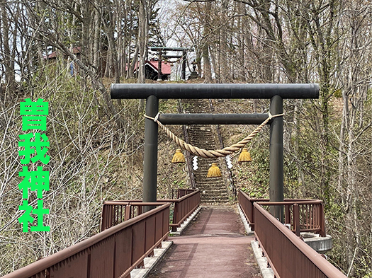
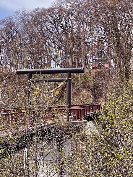
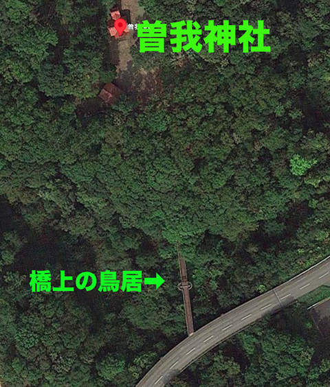
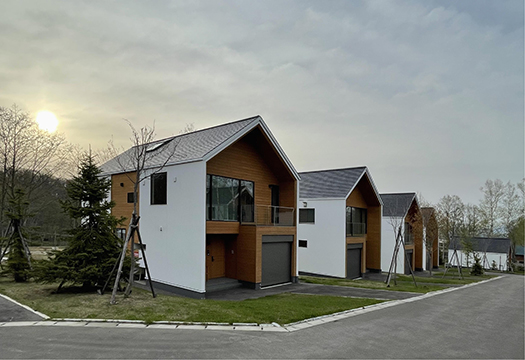
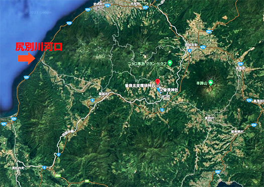
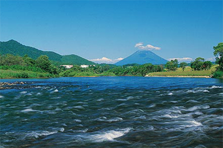
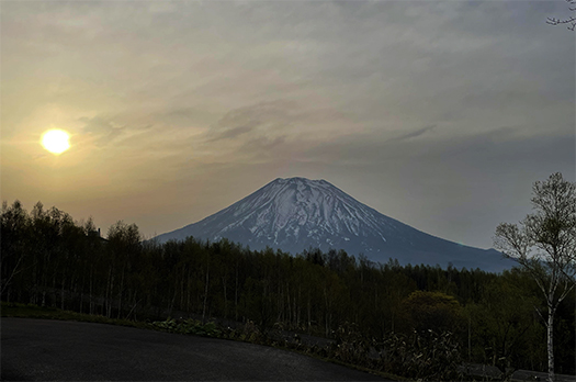
世界的な高級スキーリゾート地域として発展するニセコ地区。基本的には羊蹄山麓の農業地域ということで移動交通はクルマ利用。で、あちこちと移動していて尻別川にそそぐ支流がもたらす渓谷地形に高架道が設けられていて、そこを通りかかったら、脇に「参道」と鳥居が見えた。
「え、こんなところに?高架道から神社詣りなの?」というナゾの風景。で、地図をチェックしたら「そがじんじゃ」という神社があるとカミさんの報告。「え、蘇我神社?」って理解してしまった。蘇我神社は千葉県にある神社で、後方羊蹄とか、阿倍比羅夫とかの動乱の時代に日本史を彩る蘇我氏の末裔痕跡。
その蘇我神社があるのならば、符合すると考えられるということ急遽Uターンして参道を拝観し、本殿も参拝させてもらうことにしました。「もし蘇我神社ならば、後方羊蹄という日本書紀記述との歴史時代背景がシンクロしはじめるのではないか,ワクワク」

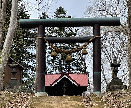
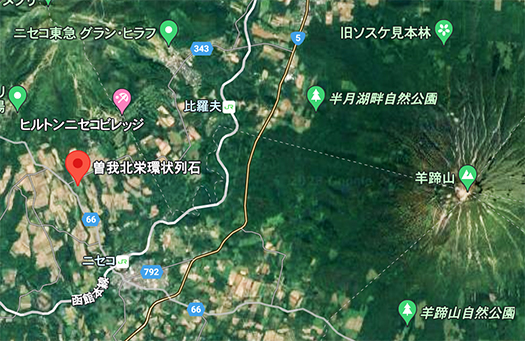
なんですが、よく神社名を確認したらヨミは「そがじんじゃ」だけれど、蘇我ではなく曽我という地名の神社と言うことがわかった。この一帯ではパワースポットとして知られている。調べてみたけれど、由緒はあんまり確定できない。明治以降に入植して成功した「曽我」という人物が建立したようです。1901年(明治34年) 曽我子爵がこの地の開拓を始める。1904年(明治37年) 創建。ということで周辺一帯に「曽我」という地名。
祭神 天照皇大神 八幡大神
1901年(明治34年)曾我子爵が開拓した曽我地域
1958年(昭和33年)神社創建。
で、どうしてパワースポットになっているのかは不明。たぶん橋の上を渡っていく非日常感が話題になっているのでしょうか。つい最近の創建と言うことなので、場所柄からのイメージと思われます。
しかし、日本というのは全国に八百万のように神社仏閣が存在し人びとがそうしたものに畏敬する文化を持っている。そういう社会性がひとびとの心性にいつしか染み込んで行っている部分がある。欧米のように一神教社会ではないけれど、それでもおだやかな社会的調和性が特徴になる社会。また歴史のヒントが無数にタイムカプセル化しているとも言える。この神社のように、高々つい最近、昭和時代の創建なのに大事にする社会。ホッコリとしたこういう文化は大切だと思う。

English version⬇

[Elevated road to bridge approach & torii, Niseko “Soga Shrine”].
I was excited to visit this shrine, mistaking it for the Soga Shrine, but unfortunately, it was not. I was excited to visit the shrine, mistaking it for Soga Shrine, but was disappointed (laugh). I was so excited to visit the shrine, but I was disappointed.

The Niseko area has developed into a world-class luxury ski resort area. Basically, it is an agricultural area at the foot of Mt. Yotei, so transportation is by car. As I passed by an elevated road in a valley formed by a tributary of the Shiribetsu River, I saw an “approach road” and a torii gate on the side.
What? Are you going to pay a visit to a shrine from an elevated road? It was a riddle scenery. I checked the map and found a shrine called “Soga Shrine,” my wife reported. I understood. I understood. Soga Shrine is located in Chiba Prefecture and is a trace of the descendants of the Soga clan that colored Japanese history during the period of upheavals such as the backward Yotei and the Abenohirau.
I made a hasty U-turn to visit the approach to the shrine and the main shrine. If it is the Soga Shrine, the historical background of the backward Yotei in the Nihonshoki Chronicles will begin to synchronize, which is very exciting.

However, when I carefully checked the name of the shrine, I found that it is not Soga but a shrine in the name of a place called Soga, although the yomi is “Soga-jinja”. It is known as a power spot in this area. I looked up the name of the shrine, but its history is not very definite. It seems that the shrine was built by a successful settler named “Soga” after the Meiji era (1868-1912), Viscount Soga started to settle the area in 1901 (Meiji 34), and the shrine was built in 1904 (Meiji 37). The whole surrounding area is therefore named “Soga”.
Gods of worship Amaterasu-O-no-Mikoto Hachiman-O-no-Mikoto
1901 (Meiji 34) Soga area developed by Viscount Soga.
The shrine was founded in 1958.
So, why it is a power spot is unknown. Perhaps the unusual feeling of crossing over a bridge is the topic of conversation? Since the shrine was founded only recently, it is thought to be an image from the location.
However, in Japan, there are as many as 8 million Shinto shrines and Buddhist temples throughout the country, and people have a culture of reverence for such things. This social nature has somehow become ingrained in people’s mentality. Although it is not a monotheistic society like in the West, it is still characterized by a gentle social harmony. It can also be said that there are countless time capsules of hints of history. Like this shrine, it was built only recently, in the Showa period, and yet it is still cherished by the society. I think it is important to have a culture like this, where people can feel relaxed.

【日本海航路の難所・女人禁制「神威岬」と北海道開発】


 縄文の約3,000年前とされる羊蹄山麓の環状列石遺構の見学から触発されての古代日本と北海道島の歴史探訪。基本交通路は船舶による交通手段の時代。阿倍比羅夫は、諸説はあるけれど北海道島に「後方羊蹄」という地名痕跡を確実に残している。
 北海道人としては、しかしその後、江戸期まで日本史との関わりの痕跡が途絶えることが不可思議。いくつかの伝承や文献記録などから、推理するくらいしか手掛かりに乏しい。
 伝承としては「義経伝説」があって、写真の積丹・神威岬を限界としてこの地以北が「女人禁制」とされたことが記録されている。義経が頼朝からの追捕の手を逃れて蝦夷地に逃避行したという「伝説」。最後は大陸に逃れて、その後ジンギスカンになったという荒唐無稽の伝承。その一節に、この神威岬にまつわるアイヌの族長の娘との悲恋物語。義経と恋仲になった娘は、追っ手から逃れるためにこの神威岬から出発した義経を追って、荒波にさらわれて命を落としたとされる物語。
 ながく北海道島が日本史の表面から姿を消している時期。平家物語の語り部として全国の村々の祭りなどの機会に琵琶の伴奏つきの物語を語った法師たちから、その内容を受け取ったその時代の大衆が、判官びいきという心象を持ったことは蓋然性が高い。そういう心理が多様な義経伝承を生んだものだろうか。
 ニセコ地域からの帰り道、積丹半島をぐるっと回って帰ることにした。

 神威岬は1−2回は来ているけれど、今回はまことに「風極」とでも言える強風。日高の襟裳岬でも体験したけれど、大人でも立っていられないくらいで、子どもたちはふざけていると実際に風に飛ばされて転んだりしていた。岩礁地帯で岬自体、半島自体が巨大な造岩活動の凄まじさを表現する地形と、この風の強烈さで江戸期くらいまで開発が遅れたのかという体感を持った(笑)。
 実際に「女人禁制」としたのは、江戸期の松前藩による海産資源・経済利権の秘密保持が目的だったのだろうけれど、このことが北海道開拓進展に桎梏となったことも事実。神威岬から先の石狩湾以北に行くには舟しかなかったので岬を通行禁止にされると女性は石狩以北には行けなかったのだ。女人禁制とは、それ以北に「定住するな」「出稼ぎしか認めない」という宣言であり、地域開発するという意思はどこにも見えず、ただただ、自藩の交易利得にしか価値感を持っていない地域政権。事実上の松前藩による「開拓禁止」政策だった。
 今日の北海道と江戸期の松前藩にはどのようにも「継承性」がない。たぶん全国の大名領地と明治以降の関係性の中で、北海道ほど断絶が際だっている地域もないだろう。「直轄支配」時期のこともあり、むしろ江戸幕府の方が開明的に北方防衛意識を高く持って北海道島の未来と向き合っていた。松前藩が南方の薩摩のような藩であったら、その後の日本史は大きく変化した可能性がある。

English version⬇

Cape Kamui, a difficult point on the Japan Sea route and forbidden to women, and the development of Hokkaido
The Matsumae Clan of the Edo period delayed the development of the Shakotan Peninsula north of Cape Kamui by taking advantage of a legend about Yoshitsune. A clan that clung to its marine products trading interests and had no regional development policy. The Matsumae Clan

A historical exploration of ancient Japan and the island of Hokkaido, inspired by a visit to the ringed stone remains at the foot of Mt. Yotei, which are believed to date back about 3,000 years to the Jomon period. The basic transportation route was by ship in those days. Abenohirau definitely left traces of the place name “backward Yotei” on the island of Hokkaido, although there are various theories.
As a Hokkaido native, however, I find it strange that traces of the area’s connection to Japanese history ceased after that, until the Edo period. There are only a few clues that can be deduced from folklore and written records.
There is a “Yoshitsune legend” that records that the area north of Cape Kamui, pictured in the photo, was forbidden to women. The “legend” tells of Yoshitsune’s escape to Ezo, escaping from Yoritomo’s pursuit. The wild folklore says that he finally escaped to the continent and subsequently became Genghis Khan. In this passage, there is a tragic love story about the daughter of an Ainu chief who was in love with Yoshitsune. It is said that the daughter, who fell in love with Yoshitsune, was snatched away by a stormy sea and lost her life in pursuit of him as he departed from Cape Kamui to escape his pursuers.
It is highly probable that, at a time when the island of Hokkaido had long disappeared from the surface of Japanese history, the public of that era, who received the content of the tale, had a mental image of a favoritism toward the priests who told the story with biwa accompaniment at festivals and other occasions in villages across the country as storytellers of the Heike tale. Such a mentality may have given birth to the diverse folklore of Yoshitsune.
On the way back from the Niseko area, I decided to go around the Shakotan Peninsula.

I have been to Cape Kamui once or twice, but this time the wind was so strong that it could be described as a “wind pole. Even adults could not stand up, as we experienced at Cape Erimo in Hidaka, and children were actually blown away by the wind and fell down when they were joking around. The cape itself is a rocky reef area, and the cape itself and the peninsula itself have a topography that expresses the tremendous rock-making activity, and I had the feeling that the development of the area was delayed until around the Edo period because of the intensity of this wind (laugh).
The reason for the “no women allowed” policy may have been to maintain the secrecy of the Matsumae clan’s marine resources and economic interests during the Edo period, but it is also a fact that this policy was a deterrent to the development of Hokkaido.
The prohibition of women was a declaration that “no settlement” or “only migrant workers” would be allowed north of the boundaries of Hokkaido, and the regional administration had no intention of regional development, but only a sense of value for its own trading interests.
There is no “inheritability” in any way between today’s Hokkaido and the Matsumae clan of the Edo period. Perhaps no other region in Japan has such a remarkable disconnect between the feudal lords’ domains and their relationship with each other since the Meiji era as Hokkaido. Because of the period of “direct rule,” the Edo shogunate faced the future of the island of Hokkaido with a high awareness of northern defense in a rather open-minded manner. If the Matsumae clan had been like Satsuma in the south, the subsequent history of Japan could have been very different.

【1364年前と現代 大和王権・世界との遭遇 in羊蹄山麓】


連休中に訪れていたニセコ地域で縄文期遺跡など思わぬ歴史事実との遭遇。歴史好きの本性は、最近すっかり本州地区行脚に費やされていましたが、今回で北海道地元にスポットが当たってしまった。北海道人としては、後世のひとたちにこういった歴史情報を解明しておく責任の一端はあるかもしれない。もちろん専門研究者の情報に基づいて、広く興味を拡散して世論を醸成するという意味合い。
この羊蹄山周辺地域はいまや世界的な雪質レベルでのリゾート開発が盛ん。世界的なスキーリゾートとして欧米からの来訪者で大いに賑わっている。図のように「NISEKO UNITED」ということでシルキースノーゾーンが広がっている。日本人ではスキー人口はそれほど伸びているとは聞かないけれど、シーズンになると英語などの方が当地では優勢になるそうです。わたし自身はスキー学校授業程度ほぼ興味がない。そういうことなので来るのはもっぱら夏場ということになるけれど・・・。
どうもこの地にはそういう「外からの注目」が集まりやすいのかも知れない。今回歴史好きとしてふとした気付きから日本・ヤマト王権が北方国防対策として、この地域に軍団遠征を200艘もの大船団で行った事実は大変なインパクト。659年当時はオホーツク人という北方からの「外圧」への対応だったのだろうが、ある意味では土地が持つ「気」のようなものが外部から人を呼び寄せるのかも知れない(笑)。
写真のように北海道の建築関係者にとって当地のリゾート開発建築の最初期は素性の定かでないオーストラリアの不動産業者による進出で、信用状況でもやや不安を持たざるを得ない取引だったという。サンモリッツなどの欧米のハイエンドリゾート需要、そうした活発な投資活動は北海道全体にとって有意義。現在では多くの貸別荘群がゲレンデ周辺の好適地で新築されてきている。ヒルトンなどの欧米資本の進出もある。

さて歴史好きの阿倍比羅夫遠征での「後方羊蹄」についての調査活動。その当時の朝鮮・白村江海戦での日本側遠征船団と人員規模について、好きな歴史作家・安部龍太郎氏の論考では1艘あたり30人の兵員輸送だったとされるので、200艘船団では5,000-6,000人規模の大遠征軍団。
逆に言えばこうした大船団が編成されたので北から西に方向転換して白村江海戦に突入してしまった、とも言えるのだろうか。この軍勢が河口に上陸し、兵糧などの運搬に適した尻別川が通っている「比羅夫」という地名が残る羊蹄山麓まで、GoogleMapでの陸上歩行時間距離では8時間ほどとなっている。
この距離感であれば1−2日の行程で武装しての進軍も可能だったことだろう。
羊蹄山麓地域まで阿倍比羅夫を護送するのには50-60人程度の軍勢で十分か。環境要因を見てみればたしかに軍事移動は十分可能だっただろう。政庁の設置も可能だと思えるが、さて。

Enlish version⬇

1364 Years Ago and Today: Encounters with Yamato Royalty and the World in Yotei Foothills
Is this the local environment that attracts the most “outside attention” in Hokkaido now and in the past? World-class ski resorts and the Abenohirou expedition. …

While visiting the Niseko area during the holidays, I came across some unexpected historical facts, including Jomon-period ruins. My love of history has recently been completely consumed by my travels in the Honshu area, but this time I found myself in the Hokkaido area. As a Hokkaido native, I may have a part of responsibility to clarify this kind of historical information for future generations. Of course, this is based on information from professional researchers, but it is also meant to spread interest and foster public opinion.
The area surrounding Mt. Yotei is now being actively developed as a resort with world-class snow quality levels. As a world-class ski resort, it is very crowded with visitors from Europe and the United States. As shown in the figure, a silky snow zone called “NISEKO UNITED” is spreading. Although I don’t hear that the ski population is growing that much among Japanese, I hear that English and other languages are predominant in this area during the season. I myself am not interested in ski school classes. So I come here only in the summer.
I guess it is easy to attract such “attention from outside” to this place. As a history buff, I suddenly realized that the fact that the Yamato Kingdom of Japan conducted a military expedition with a fleet of 200 ships to this area as a measure to defend the northern part of the country had a great impact on me. In a sense, the “spirit” of the land may have attracted people from the outside (laughs).
As you can see in the photo, for architects in Hokkaido, the initial resort development construction in the area was done by an Australian real estate developer of unknown background, and they had to be a little apprehensive about the credit situation. The demand for high-end resorts in Europe and the U.S., such as St. Moritz, and such active investment activities are meaningful for Hokkaido as a whole. Many new rental villa complexes are now being built in prime locations near the slopes. There is also the entry of European and U.S. capital such as Hilton.

Now, research activities about “Rear Yotei” in the Abenohirao expedition of history buffs. According to my favorite history writer, Ryutaro Abe, the Japanese expeditionary fleet and its personnel size at that time at the Battle of Paekchon River in Joseon was said to have transported 30 soldiers per ship, so a fleet of 200 ships was a large expeditionary force of 5,000 to 6,000 soldiers.
Conversely, it could be said that such a large fleet was organized, so it changed direction from north to west and plunged into the Battle of Hakuchon River. According to Google Map, it takes about 8 hours to reach the foot of Mt. Yotei, where the Shiribetsu River, which is suitable for transporting food and supplies, runs through.
This distance would have made it possible to march armed to the teeth in one or two days.
A force of about 50-60 men would have been sufficient to escort Abephirao to the foot of Mt. Looking at the environmental factors, it would certainly have been possible to move the military. It would also be possible to set up a government office.

【阿倍比羅夫と対話した縄文の末裔の人びと】


日本書紀の記述、斉明天皇の条での阿倍比羅夫の北征。古代世界で突然のように北辺の世界の記述が出てくることから、多くの研究が日本各地で行われてきている。北海道に暮らすものとして、何度もこのナゾに問いかけてきている。今回も現地周辺を行脚しながら想像力を巡らせてきていた。わたしとしては流域面積で北海道での6番目の「大河」である尻別川流路から、羊蹄山をつねに目標としながら上っていく山麓地域のどこかが比定されるのではないかと考えている。事実として「比羅夫」という地名も残されている。地名にはタイムマシンのように伝承などの故実が表現されていると考えるのが自然だと思うのです。
この日本書紀記述を巡っては倶知安町や余市町などで、後方羊蹄(しりべし)の政庁「郡領」はわが町存在したに違いないと論争が繰り返されてきた。いまのところ郷土の歴史の一断面として今後の調査に期待するところ。
一方で阿倍比羅夫が接触した人びとについて、いろいろな解析が進んできている。7世紀頃の北海道ではアイヌ文化はまだ成立せず、それ以前の「擦文」の人びとが文化圏を築いていた。以下の図表は、JT生命史研究館「縄文人の核ゲノムから歴史を読み解く〜国立科学博物館・神澤秀明」からの参照。https://www.brh.co.jp/publication/journal/087/research/1


この解析から想起できることは本土の人びとはより現在のDNAに近く、北海道島の人びとはより縄文人に近しい存在だったと。この分析からは、この時期に阿倍比羅夫と遭遇し「郡領」設置を進言したという人びとは、より縄文人の血が強い人びとだったことが想像できる。
北海道で活躍する考古学の瀬川拓郎氏の説によれば、この時期、アムール川河口周辺発祥の北方アジア系の「オホーツク文化人」の人びとが大型海獣の狩猟を中心としたライフスタイルで北海道のオホーツク沿岸地域に進出しており、かれらは交易を通じて日本社会との接点拡大を目指して日本海側にも進出していた。
そのことからこの後方羊蹄地域の縄文由来の擦文の人びとと緊張状態に陥り、そした背景から交易相手であるヤマト王権社会に「援軍」を請うた結果が阿倍比羅夫の遠征だったのではないかとされている。
奥尻島と想定される戦場で、実際に戦闘が行われ、阿倍比羅夫に従軍した副官クラスが奥尻島で戦死したとされている。
こういった北海道島の日本史との接触記録が、しかしその後、鎌倉期くらいまで眠ったようになる。遠征した阿倍比羅夫の血統は奥州安倍氏に連なるという説もある。その経済基盤としての対北方世界「交易」の実態は奥州藤原氏の奇跡的な栄華としても明らか。
日本の北方史は多くの魅力的なミッシングリンクに満ちている。

English version⬇

[People of the Jomon descendants who conversed with Abepirāu.
From Abephirao’s expedition onward, until the Kamakura period, there was a missing link in the world of the rise and fall of the Oshu Fujiwara clan, which is poorly documented. However, there were historical facts in Hokkaido. …

The description of the Nihonshoki, the northern conquest of Abenohirau in the article of Emperor Saimei. Because of the sudden appearance of descriptions of the northern world in the ancient world, a great deal of research has been conducted in various parts of Japan. As a resident of Hokkaido, I have repeatedly asked this riddle. This time, too, I have been exploring my imagination as I traveled around the area. I believe that the Shiribetsu River, the sixth largest river in Hokkaido in terms of watershed area, is located somewhere in the foothills of the mountain range, always with Mt. In fact, the place name “Hirao” has been preserved. I think it is natural to think that place names are like a time machine, expressing folklore and other historical facts.
There have been repeated disputes in Kutchan Town, Yoichi Town, and other towns over this Nihon Shoki description, arguing that there must have been a “county seat” of government in Shiribeshi in the backward direction in our town. At present, this is just one aspect of our local history, and we look forward to further research in the future.
On the other hand, various analyses of the people with whom Abenohirau came into contact are underway: the Ainu culture had not yet been established in Hokkaido around the 7th century, and the “Scrubun” people had established a cultural sphere before that time. The following figures and tables are from “Reading History from the Nuclear Genome of the Jomon People: Hideaki Kanzawa, National Museum of Nature and Science,” JT Biohistory Research Hall.

This analysis suggests that the people of the mainland were closer to the present DNA, while the people of Hokkaido Island were closer to the Jomon people. From this analysis, we can imagine that the people who encountered Abenohirau and advised him to establish a “county fiefdom” during this period were people with stronger Jomon blood.
According to the theory of Segawa Takuro, an archaeologist active in Hokkaido, during this period, “Okhotsk Culture people” of northern Asian descent who originated around the mouth of the Amur River expanded into the Okhotsk coastal region of Hokkaido with a lifestyle centered on hunting large marine animals, and they also expanded into the Sea of Japan side, aiming to expand their contacts with Japanese society through trade. They also expanded to the Sea of Japan side in order to expand their contacts with Japanese society through trade.
This may have led to tensions with the Jomon-derived Abrahamic people of the Yotei region, and the Abenohirau expedition may have been the result of their request for “reinforcements” from their trading partners in the Yamato Royal Society.
It is said that a battle actually took place on the supposed Okushiri Island battlefield, and that the second-in-command who served with Abepirāyu was killed on Okushiri Island.
These records of contact with Japanese history on the island of Hokkaido, however, then seem to have fallen asleep until about the Kamakura period. Some believe that the lineage of the Abenohirou expedition is linked to the Oshu Abe clan. The reality of “trade” with the northern world as its economic base is also evident in the miraculous prosperity of the Oshu Fujiwara clan.
Japan’s northern history is filled with many fascinating missing links.

【阿倍比羅夫の北方遠征と「後方羊蹄」尻別川】


わたしは旅先とか、出張などで訪れる地域の「地史」への興味が非常に盛り上がるタイプなのか。歴史書は好きですがもちろん網羅的に読破しているわけではない。実際に訪問するとその周辺記憶領域が強く反応して「おい、おまえ、この辺のこと放置しているべや」とうごめき、ささやき返してくる。
今回ニセコ地域を遊動してみて、あらためて日本史との関係性に強く思いが至ってしまった。やはりこの地域と日本史の関係では阿倍比羅夫の北方遠征が強烈な古代史のインパクト。地名にまで比羅夫がある。
阿倍比羅夫は高志(越)国・越後の国司の地位にあって大化の改新時期の有力人物。この北方制圧の政治軍事行動からその後、翌年には古代日本の大敗戦である白村江へも出征している。当時の日本国家の「海軍力」は環日本海が主戦場。そこに特化して活動したことから、事実上の国家軍事部門統括だと推認可能。舟の大きさも不明だけれど180-200艘の軍団規模「大河のほとり」に進出したとされる。地元の族長たちはその勢威に圧倒されて恭順を申し出てきたのだという。この「大河」がさてどこであるのか、ということからして北海道地域史では確定的な論を持っていない。
阿倍比羅夫が置いたとされる「郡領」の位置を巡って多数の研究者たちが多年にわたって発掘などの調査活動を行ってきているとされている。国書に記載があるとは言え、そもそも事実としてそういった「建築的施設」があったのかどうかも不明なのだから、労多い作業だとは思う。
一介の歴史好きとしては研究者のみなさんの活動に期待しつつ、後方羊蹄という残された地域名と、大河という表記、そして大軍船団という歴史事実から推定して、写真のような光景が古代人にも同様に映じていたと考えられると思っている。
いまの河川名で言えば「尻別川」が擬定されるにふさわしい。阿倍比羅夫の遠征は、その後の白村江出征も国家的な海軍力の示威であり、実際の戦争行為でもあったことから、この北方遠征もそういったコンテキストと同様でしょう。この地域で族長層からは日本古代王権に対しての服従対応があったということ。
阿倍比羅夫は帰朝後、ヒグマの毛皮多数と,生きたヒグマ2頭を朝廷にもたらしたといわれる。この後方羊蹄地域の族長たちと「戦わずして外交的に勝利した」ということが真実なのだろう。郡領を設置したらと申し出たのは現地族長層からだったとされている。
さてそこで実際に阿倍比羅夫は羊蹄山の周辺地域まで「郡領」を設置しに向かったかどうか。現地族長たちにしてみると、たしかに大河の畔でその軍威にひれ伏したけれど、実際に自分たちのテリトリーまで軍の首領を導き入れるかどうかは疑問も残る。阿倍比羅夫としてもそこまで身の安全確保に自信を持てただろうか。興味津々の地域史探偵団であります(笑)。

English version⬇

Abenohirao’s Northern Expedition and the “Backward Yotei” Shiribetsu River
Yotei from the Shiribetsu River mouth area, and was offered submission by the local tribal leaders. Diplomatically, the expedition was a success. Whether or not they actually established “county fiefdom” building facilities? ・・・

Am I the type of person whose interest in the “local history” of an area I visit when traveling or on a business trip is very excited? I like history books, but of course I have not read them exhaustively. When I actually visit an area, my peripheral memory reacts strongly and whispers back to me, “Hey, you, you left this area out.
This time, as I traveled around the Niseko area, I was reminded of the strong relationship between the area and Japanese history. As one would expect, the relationship between this area and Japanese history is strongly influenced by the northern expedition of Abepirābu, which had a strong impact on the ancient history of Japan. Even the name of the place has Hirao in it.
Abenohirau was a powerful figure during the Taika Reform Period in his position as provincial governor of Koshi-no-Kuni and Echigo. From this politico-military action to control the northern part of the country, he later went to the Hakumura River, the great defeat of ancient Japan, in the following year. The main battlefield for the “naval power” of the Japanese nation at that time was the Japan Sea Rim. Since he specialized his activities there, it can be inferred that he was in charge of the de facto national military department. Although the size of their ships is unknown, it is said that they advanced to the “banks of the great river” with an army of 180 to 200 ships. The local chiefs were overwhelmed by the force of the army and offered their respect. The history of Hokkaido does not have a definite theory as to where this “great river” was located.
Many researchers have been excavating and investigating the location of the “county fiefdom” where Abenohirau is said to have placed it for many years. Although it is mentioned in the National Records of Japan, it is still unclear whether or not such an “architectural facility” existed in the first place, so it is a laborious task.
As a history buff, I look forward to the activities of researchers, but based on the name of the area, which remains as Yotei in the back, the description of the river, and the historical fact of a large military fleet, I believe that the ancient people would have seen the same scene as in the photo.
In today’s river names, the Shiribetsu River is an appropriate name for the area. The Abenohirao expedition would be similar to such a context, as the subsequent expedition to the Hakumura River was also a demonstration of national naval power and an actual act of war. It means that there was a submissive response to the ancient Japanese kingship from the chiefs in this region.
Abenohirau is said to have brought a large number of brown bear pelts and two live brown bears to the imperial court after his return. It is probably true that he “won a diplomatic victory without a fight” with the chiefs of this backward yotei region. It is said that it was the local chiefs who offered to establish a county fiefdom.
Now, whether or not Abepirābu actually went to the area around Yotei to establish a “county fiefdom” is not clear. The local chieftains were indeed prostrated by his military might on the banks of the great river, but it is doubtful that they would actually lead a military leader into their own territory. Would Abenohirau have been so confident of his own safety? The Local History Detective Corps is very curious (laughs).

【神々が坐す 素朴な自然崇拝の「後方羊蹄」地域】


きのうのニセコでの環状列石探訪での古代縄文人の痕跡に気付かされ、知らず知らずわたし自身も陥っていた北海道地域観、大自然がそのまま残っている未踏の開拓地的な史観がゆらぎを見せ始めています。人跡・文化性への極度の軽視から目を見開かされたような思いがある。
たしかに人跡の歴史には連続性は乏しいけれど、それなりに点景としては存在していることに改めて思いが至っていました。
日本史との接点ではこの羊蹄山周辺地域・ニセコは「後方羊蹄〜シリベシ」という地名地域として、阿倍比羅夫の遠征期に名を記している。この漢字の文字記述とよみがなとの乖離感はたぶん日本語の中でも特異な例でしょう。
さらに現代地名表現としての後志と書いてシリベシと読むのも、この表記・音読との関係性が出発点なのでしょう。他地域のみなさんは漢字表現とよみに強い違和感を覚えるだろうと思います。
阿倍比羅夫の北方遠征については以下の「『福井県史』通史編1原始・古代」記述がある。「比羅夫は水軍180~200艘を率いて北征したがそのための造船はもとより、兵員や食糧の調達は莫大だった。その負担に堪えたのはおそらく能登・加賀を含む広義の越前が主だったであろう。比羅夫の遠征軍は、斉明天皇四年(659年前後)に齶田・渟代(秋田・能代)を平定。渡嶋の「蝦夷」をも綏撫して帰還。この年にまた比羅夫は粛慎を討って帰還した。同五年には飽田・渟代二郡の「蝦夷」のほか、津軽郡・膽振「蝦夷」を饗応し進んで肉入篭に至り、後方羊蹄に郡領を置いて帰った。同六年にも、渡嶋の「蝦夷」を味方として幣賂辨島の粛慎と戦った。」
ここに記述された「後方羊蹄」という地域は常識的に考えれば写真のような現代の羊蹄山周辺地域。ここに「郡領を置いた」という記述からは、一定の人口社会地域であることが推定される。きのう見たような約3,000年前当時の縄文期の遺跡から、この1,364年前当時まで、少なくとも1,700年程度は一定の集落社会が形成され続けていたと考えることが自然なのではないか。こういう推論に基づいて丹念に考え続けることが必要なのかも知れません。
現代の北海道地理観でも、積丹半島の先端部・神威岬は猛烈な強風で知られ、そこを超えた石狩平野地域は江戸期くらいまで女人禁制とまでされていた通行困難地域。いまでも札幌から移動するには山岳地域を抜ける必要がある。いわゆる蝦夷ヶ島の交通可能エリアとしては、ニセコ地域は日本社会との接触可能圏だったと考えられる。そういう背景があって「郡領を置いた」のだろう。現代ではこの地域は海外との接触が非常に高まってもいる地域。歴史探偵団的にたいへん面白みがある。

English version⬇

A simple nature-worshipping “backward yotei” area where the gods sit.
The area where Abenohirau “established a county fief” during his northern expedition 1,364 years ago. 3,000 years ago, during the Jomon period, we can predict the continuous existence of a populated society. The area was “the county seat” during Abenohirau’s northern expedition 1,364 years ago.

Yesterday’s visit to Niseko and the traces of the ancient Jomon people were a reminder to me that my own view of Hokkaido as an unexplored frontier with its natural wonders intact is beginning to waver. I feel as if my eyes have been opened from the extreme disregard for human remains and culture.
It is true that there is little continuity in the history of human sites, but I have come to realize once again that they exist in their own way as a point of view.
In terms of contact with Japanese history, the area around Mt. Yotei, Niseko, was named “Yotei Shiribeshi” during Abenohirou’s expedition. This divergence between the Kanji character description and the yomigana is probably a unique example in the Japanese language.
Furthermore, the modern use of “Goshi” as a place name expression, reading “Shiribeshi,” is also probably based on this relationship between the written and phonetic readings. I believe that people from other regions may feel a strong sense of discomfort with the Chinese characters and pronunciation.
The following is a description of Abeno Hirao’s expedition to the north in the “History of Fukui Prefecture,” General History, Part 1, Primitive and Ancient Times. The burden of building ships and procuring men and food for the expedition was enormous. It is likely that the burden was borne mainly by Echizen in the broad sense of the word, including Noto and Kaga. Hirao’s expeditionary force pacified Jinden and Nugushiro (Akita and Noshiro) in the 4th year of the Emperor Saimei (around 659). He also returned after having pacified the “Emishi” of Watarajima. In the same year, Hirao also returned after defeating Sukune. In the same year, he served “Ezo” in Ajita, Nuyo, Tsugaru-gun, and Ezo in Echigo-Tsumari, and returned to Yotei with his county territory in the rear. In the same year, he fought against Sukune of Beshima with the “Emishi” of Watarajima as his allies.
The area described here as “back Yotei” is, to the casual observer, the area around modern Mt. The description of a “county fiefdom” here suggests that it was an area with a certain population. It is natural to assume that a certain settlement society had continued to be formed for at least 1,700 years from the Jomon period ruins we saw yesterday, about 3,000 years ago, to this time, 1,364 years ago. It may be necessary to continue to think painstakingly based on this kind of reasoning.
Even in the modern geographical view of Hokkaido, Cape Kamui, at the tip of the Shakotan Peninsula, is known for its ferociously strong winds, and the Ishikari Plain area beyond Cape Kamui was a difficult area where women were even forbidden to travel until around the Edo period. Even today, travelers from Sapporo must pass through mountainous areas. The Niseko area is thought to have been the only area in the so-called “Ezo-gashima” area that was accessible to Japanese society. It is against this background that the “county territory” was established. In the present day, this area is also a region where contact with the rest of the world has increased greatly. It is very interesting from the perspective of the Historical Detective Corps.

【古代天文科学・羊蹄山頂同緯度の縄文「曽我北栄環状列石」】


連休初日なので遠出しております。最近出掛けることが多いニセコ方面。カミさんが食事改善に伴って新鮮野菜探究にまっしぐらで、アスパラガスの旬の食感に強いこだわりを求め始めていまして、ニセコビュープラザ道の駅に出店される地元農家の朝市をたのしみに出掛けている次第。という動機について詳しく知ったのは実はきのうでして(笑)、わたしとしては「そんなんなら、地元の人にいつころから出荷するか,聞けばいいっしょ」ということなのですが、なにせコミュニケーション不足(笑)。
で、きのう確認したところこちらでの出荷の旬は今月中旬〜下旬とのことでまだシーズン前ということであります。でもまぁ、それは動機のひとつに過ぎない。遠出ドライブはキライではない。
ということで、その近隣であちこち巡っていたら、こちらの「曽我北栄環状列石」に遭遇。考古好きのわたしとしても強く惹かれた次第。情報では「羊蹄山山頂火口縁の北側と同緯度(北緯42度49分35秒)」なのだということなのです。先日の日本古代王権ゆかりの淡路伊弉諾神宮でも触れたのですが、その所在地の真東に大和藤原京や、伊勢神宮内宮が位置するという古代での「天文科学」の存在痕跡。
そのような天文科学に基づいた遺構が、北海道の羊蹄山周辺の高地平野部に存在するという事実を初めて知ったのであります。写真上はその遺構から真東方向に羊蹄山を見たところ。その下のGoogleMapは、正確な東西南北通りのマッピングなので、たしかに羊蹄山頂とこの遺構が、地球物理の解析結果の現代科学知識とレベルを共にして、同緯度に存在することが目視確認される。
昭和26年、東京大学教授・駒井和愛氏による発掘調査。第1号から第4号の4基の環状列石が残されており、発掘調査で人骨と思われる骨片、石錐、翡翠製の臼玉、深鉢型縄文後期式土器が発見され、研究者は祭祀的なものというより、環状列石墓であると主張されている。3000年ほど前、縄文人が居住地と墓を分離したときの墓であると。
ニセコ町では縄文時代の遺跡は発見されているが、中世(鎌倉、室町)から江戸後期に至るまでの記録(アイヌ時代)の遺跡が発見されておらず謎となっている。幕末の探検家・松浦武四郎は羊蹄山を『日本書紀』に記された後方羊蹄(しりべし)と推測している。
考古数寄としては、まことに好きな展開(笑)。たまたまカミさんの情報調査がきっかけで訪問出来たのですが、非常に刺激を受けています。灯台もと暗し、古代浪漫、淡路島と同レベルの事実が地元北海道でも、であります。ワクワク。

English version⬇

Ancient Astronomical Science, Jomon “Soga-Hokuei Ring Stones” at the same latitude as the summit of Mt.
Is this an ancient scientific example similar to the case of Awaji Izanagi Shrine and the Inner Shrine of Ise Jingu at the same latitude? An encounter with a fact that makes my archeological blood boil. …

It is the first day of a consecutive holiday, so we are going away. Recently, we have been going out to Niseko. My wife has been on a quest for fresh vegetables as she has been improving her diet, and she has started to pay close attention to the texture of asparagus in season. I learned more about their motivation yesterday (laugh), and I thought to myself, “If that’s the case, why don’t I just ask the locals when they start shipping their produce?
(Laughs) So, I checked yesterday, and the shipping season here is from the middle to the end of this month, which means it is still before the season. But, well, that is only one of the reasons. I am not averse to a long drive.
So, as I was cruising around the neighborhood, I came across the “Soga Hokuei Loop Stones” here. As an archeologist, I was strongly attracted to it. According to the information, it is located at the same latitude (42 degrees, 49 minutes and 35 seconds north latitude) as the northern side of the crater rim of the summit of Mt. As mentioned in the recent article on Awaji Izanagi Shrine, which is associated with ancient Japanese royalty, the Yamato Fujiwara Capital and the Inner Palace of Ise Jingu are located directly east of the site, which is a trace of the existence of “astronomical science” in ancient times.
This was the first time I learned of the existence of such astronomical remains in the highland plains around Mt. The upper photo is a view of Mt. Yotei looking directly east from the remains. The GoogleMap below is an accurate mapping of the north-south-east-west street, which confirms that the summit of Mt. Yotei and these remains are indeed at the same latitude and level of modern scientific knowledge of the geophysical analysis.
Excavation by Professor Kazuai Komai of the University of Tokyo in 1951. The excavation revealed bone fragments, a stone cone, a jade mortar ball, and a deep bowl-shaped Late Jomon-style earthenware, which researchers claim are annular tombs rather than ritual tombs, dating back about 3,000 years, when the Jomon people separated their graves from their settlements.
Although Jomon-era sites have been discovered in Niseko Town, the remains of records from the Middle Ages (Kamakura and Muromachi) to the late Edo period (the Ainu period) have not been found and remain a mystery. Takeshiro Matsuura, an explorer at the end of the Edo period, speculated that Mt. Yotei was the backward Yotei (Shiribeshi) mentioned in the Nihon Shoki (Chronicles of Japan).
As an archaeologist, I really like this development (laughs). I happened to be able to visit the site because of Kami’s information research, and I am very much inspired. It is a fact that the same level of darkness under the lighthouse, ancient romance, and Awaji Island can be found in my hometown, Hokkaido. I am excited.

【連休は自然回帰型でこころのリフレッシュ】


写真は毎日の早朝散歩コース、北海道神宮〜円山公園の池に棲息しているオシドリの雌雄。北海道では雪が融けて花々の一斉開花が一段落してくると、動物たちの繁殖シーズンが始まる。
ちいさなオシドリコミュニティのなかでやがて「オシドリ夫婦」としてつがいが形成されていくのですが、そういう予感があるのかないのか、という時期であります。毎年、もう少しすると雌雄のつがいたちは群を出発してランデブーデートに勤しむようになる。この池から遠く500mくらい離れた円山の山裾などでよくデートの様子を見かけるようになる。仲良きことはすばらしい、と若さに応援したくなる(笑)。
雌雄の様子を見ていると、のびのびとした体動作を感じるのが2枚目のメスの方で、1枚目のオスの方はわたしの構えるiPhoneに対して注意して、首を立てて警戒感を持っている様子がわかる。万が一、わたしが悪意を持った所業に及べば、即座に逃げ出すような緊張感をただよわせている。メスの方は、そういう過剰反応は見せることなく、淡々と現実世界に対して肯定的な生き方を生きているように思える。
やっぱり女の力はすごい。オスは目立つ毛色で着飾ってメスの注意をひくのがかれらの世界の掟。かれらの世界でのペアリングでは雌雄どちらがより強い「選択行動」に及ぶのかはわからないけれど、わたしども人間の男として見ていても、メスの方がどっしりと落ち着きがあって好ましい(笑)。はじめのうちはわたしもオスたちの派手な羽毛の色彩に驚いていたけれど、見る毎にメスの「しなやかさ」の方に惹かれていく。

きのうまでの超多忙がなんとか一段落して、あとは直近の目標については連休明け2日間程度に作業が残るだけ。ただ、カミさんは月末経理作業もあって仕事が立て込んでいた。
ことしは北海道、雪融けもサクラ開花も早くて、もうサクラは札幌では散っている。そして百花繚乱のようにさまざまな花々が一気に妍を競うシーズンになりました。きょうからの連休はなるべくノンビリと自然の様子にふれあって過ごしたいと思います。きょうは寒暖の差が激しく最低気温2°で最高気温24°にもなるそうです。体調管理には留意して、自然と同期するように過ごしたいと思います。

English version⬇

Refresh your mind by returning to nature during the consecutive holidays.
The mandarin ducks, in their natural habitat, heal me. I want to change from a slammed brain and hippocampus full of blood to the rhythm of nature. The rest of the day is a time of restoration and relaxation.

The photo shows a male and female mandarin duck living in a pond in Maruyama Park, a daily early morning walking course between Hokkaido Shrine and Maruyama Park. In Hokkaido, when the snow melts and all the flowers are in bloom at once, the breeding season for animals begins.
In the tiny mandarin duck community, mating pairs will eventually form as “mandarin duck couples,” and this is the time of year when we wonder whether we have such a premonition or not. Every year, a little later, the male and female mates leave the flock to work on their rendezvous date. I often see them dating at the foot of Mt. I was tempted to cheer them on in their youthfulness, saying, “It’s wonderful that they get along so well with each other.
When I look at the male and female, the female in the second photo is more spontaneous in her body movements, while the male in the first photo is more alert, holding his head up to my iPhone. The male in the first photo is standing at attention to my iPhone, and seems to be on the lookout for me. The female does not show such an overreaction, but seems to be living a positive life in the real world without hesitation.
The female’s power is amazing. It is a law in their world that males should attract females’ attention by dressing up in conspicuous fur colors. I don’t know which of the sexes is more selective in their pairing behavior, but as a human male, I prefer the female to the male because she seems to be more relaxed and calm (laughs). At first, I was surprised at the colorful feathers of the males, but the more I looked at them, the more I was attracted to the “suppleness” of the females.

The extremely busy schedule up until yesterday has somehow come to an end, and I only have about two days of work left to do before the end of the holidays to achieve my latest goals. However, Kami had a lot of work to do, including accounting work at the end of the month.
The snow melted and the cherry blossoms bloomed early this year in Hokkaido, and the cherry blossoms have already fallen in Sapporo. And it is now the season for various flowers to come into bloom at once, as if a hundred flowers are blooming at once. I would like to spend the consecutive holidays starting today as leisurely as possible in contact with nature. Today’s temperatures are said to range from a low of 2°C to a high of 24°C. I will take care of my physical condition and try to spend my time in sync with nature.

【連休の谷間なのにストレス性疲労大襲来(泣)】


さて連休に突入していますが、最近すっかり増えてきたストレス性労働の数々・・・。人間の脳味噌では「海馬」と呼ばれる領域が、いわゆる論理的思考の場所だそうですが、この部分がフル動員されるのが公的申請などの対お役所業務。
もちろん言語を使ってやり取りをするわけですが、わたしのように情緒や雰囲気のような住宅空間をテーマにしてきた人間は、どちらかというとあいまい性の部分をどう表現するかと考える感受性言語志向。そういった志向とは、ほぼ正反対の脳の部分を動員することになる。
「えーっと、この文章はどういう事象を特定しているのか?」という基本的な部分が、法律などの文言、きわめて限定性の高い言葉で埋め尽くされている。主語と述語、修飾語の間に寸分も拡散性のない文章が羅列されている。凡人的海馬をフル動員しても、なかなか整理整頓できない。
チコちゃんに叱られるように「ボーッと」生きてきたことがいまさらのように悔やまれる(泣)。

ということで、ここのところ継続している食習慣改善努力にはマイナス。たぶん人間は論理限定性の高い領域を長時間活動させ続けると、本能的に「無性に食欲が高まる」。
ほかにもイライラ要因が高まる事柄があり、ストレスMAX状態がやってきて、いまの食生活改善行動に強烈な破壊的圧力が加わってくる(笑)。「もういい、好きにしろ」みたいな爆発性欲求がこころの内部に芽生えてくる。たぶん、図のような海馬周辺に異常な血流増加があって過熱ヒートアップし、我慢するとか、抑制するという脳の働きが攻撃されるのではないか。
上の写真は食事改善中に唯一食べたにぎり寿司。最近わたしのにぎり寿司はシャリ少なめが基本でなるべく小さく、女性に合わせるように(カミさんの好み)握っているのですが、この外食寿司ではシャリがどんと大きく、ネタも肉厚たっぷり感で迫ってきていた。
これでもか、と過食を唆すような姿カタチ。メニューではホントはこのほかにそばもセットされていた(笑)。ただ、このときは前後の食事はごく控えめだっし、また休日と言うこともあり、全体としては抑制が効いていた。
過熱する海馬領域と必死で自己抑制の戦いを繰り広げておりますが、食事改善の戦い、始めてから20日あまり。そろそろ本格的な関ヶ原が見えてきたようであります。
ストレスと食欲の抑制、なんとか頑張りたい。さて、自分は信じられるか。

English version⬇

[It’s the trough of a holiday weekend, but stress fatigue has struck hard (tears).
The Sekigahara decisive battle of the battle for better diet is approaching. The summit battle between appetite and inhibitions that are about to erupt. …

Now that the holidays are upon us, the number of stressful labors that have been completely increasing lately…. In the human brain, the area called “hippocampus” is said to be the place for logical thinking, and this area is fully mobilized in official applications and other bureaucratic work.
Of course, we communicate using language, but people like me, who have focused on the theme of residential space, such as emotion and atmosphere, are more susceptible to language, thinking about how to express ambiguity. This is almost the opposite of that kind of orientation, and it mobilizes the part of the brain that is the opposite of that.
The basic part of the brain that says, “Well, what event does this sentence identify?” The basic part of the brain that says, “Well, what is this sentence specifying?” is filled with extremely restrictive language, language such as laws. The sentences are listed without the slightest diffusion between subject, predicate, and modifier. Even if you mobilize your mediocre hippocampus to the fullest, it is difficult to keep things in order.
I regret that I have been living “in a daze,” as Chico would scold me (tears).

So, this is a negative for the efforts to improve eating habits that have been ongoing for some time now. Perhaps humans instinctively have an “irresistible appetite” when they keep a highly logical and limited area active for a long period of time.
There are other matters that increase the frustration factor, and the stress maximal state comes in and adds intense destructive pressure to the current dietary habit improvement behavior (laughs). (Laughs.) Explosive desires like, “Enough, do as you please,” sprout inside the mind. Perhaps there is an abnormal increase in blood flow around the hippocampus as shown in the figure, which causes overheating and attacks the brain’s functions of endurance and inhibition.
The photo above is the only nigiri-zushi I ate during my diet improvement. Recently, I have been making nigiri-zushi with a smaller rice ball to suit women (my wife’s preference), but at this sushi restaurant, the rice ball was huge, and the ingredients were thick and filling.
The sushi at this sushi restaurant had a large rice and the ingredients were thick and filling, as if to suggest overeating. The menu actually included soba noodles as well (laugh). However, the meal before and after was very moderate, and it was also a holiday, so the overall effect was restrained.
I have been fighting a desperate battle of self-control against the overheated hippocampus area, and it has been more than 20 days since I started this battle to improve my diet. It has been more than 20 days since I started the battle to improve my diet, and it seems that I am about to see the real battlefield.
I want to do my best to control stress and appetite. Now, can I believe in myself?

【鳴門うずしお・伊弉諾神宮太陽の道 おのころ島神社探訪-3】


年末年始時期には雪で閉ざされる北海道を離れ、本州以南地域を旅することが習慣化。その旅先も四国などが中心になって最寄りの利便のいい空港は神戸空港。そこから気ままな旅程を組めるレンタカーでの移動が通常ルートになった。そうすると淡路島・瀬戸内海地域行脚が定番化する。
淡路島は環瀬戸内圏の移動交通の要衝。札幌函館間往復600kmが一般的移動範囲である北海道人としては、淡路島というのはそれこそ指呼の距離感覚。旅するうちに、淡路には国生みにまつわる伝承や神社などの存在が多いことに気付かされるようになる。こうした流れで今回は深掘り型におのころ神社参詣。
どうも天沼矛(あめのぬほこ)神話について中央構造線の存在と、鳴門のうずしおのことが強く想像力を刺激される。〜イザナギイザナミの二神は神聖な沼矛(ぬぼこ)で国造り。天の浮橋に立ち授かった矛で混沌とした世界をかき回した。潮をゴロゴロと鳴らし引き上げた矛の先から落ちた雫が固まって島となった。〜
この「かき回し」伝承と鳴門のうずしお、そしておのころ島の擬定地・沼島の上立神岩などの符合に、古代の先人たちの列島自然地形観察の「科学的」解析結果を見るように思える。
そしてさらに淡路の伊弉諾神宮で見ていた「太陽の運行図」が思い起こされる。この神宮の真東には飛鳥藤原京や伊勢神宮などが位置しているという宮司さん作成になる説明石版図。この図を見ていたときにはこじつけ的な牽強付会説ではないかと疑念を抱いていたのですが、考えて見ると、古代の稲作農業の支配者たる王権にとっては、季節運行の民衆への明晰な説得力のある指示が不可欠だった。いつタネを植え、田にはいつ苗を植えるべきか、それへの合理的判断と指示が決定的に重要だと考えられる。そこには天文観察から自然地形観察、そして太陽の季節運行など多様な解析作業があっただろう。それらは当時の「科学根拠」そのものだっただろう。
国生み神話にあってなぜ淡路が特別な地位を受けていたのか。やはりヤマト王権にとって非常に重要な出自地域だったことを表している可能性が高いと思う。真東に初期王権地の飛鳥・藤原京があり、そこをめざして「東征」した神武の東征行動の方向性が腑に落ちるように思われる。古代には神話であると同時に合理的な根拠行動だったと思われる。神武は橿原に宮を建てたとされるけれど、その子孫・崇神は祭政分離を目指して、伊勢に祭祀中心を移動させ定めていくようになる。
このような王権としての行動意思決定に太陽の道行きが深く考慮されたことは自然だろう。天文観察での北斗星を中心にして方位観測を重ねたに違いない。ただ、たくさんの先人の列島自然観察という経験知はあったにせよ、太陽の道の詳細な特定方法はどうであったのか、現代人としては大きな疑問に突き当たらざるを得ない。

English version⬇

Naruto Uzushio, Izanagi Shrine, and the Path of the Sun: Exploration of Naruto Uzushio and Izanagi Shrine – 3
Asuka, Fujiwara-kyo and Ise Jingu are located directly east of Izanagi Shrine. The Yamato kingdom “conquered” the east to that place. Is there any scientific basis for the ancient principle of action? ……

During the year-end and New Year’s holidays, it has become a habit to leave snowy Hokkaido and travel south of Honshu. The destinations of these trips are now mainly in Shikoku and the nearest convenient airport is Kobe Airport. The nearest convenient airport is Kobe Airport, from which the usual route is to rent a car for a flexible itinerary. In this way, trips to Awaji Island and the Seto Inland Sea region became the standard route.
Awaji Island is a key location for transportation in the Seto Inland Sea area. For Hokkaido residents, who generally travel 600 km round trip between Sapporo and Hakodate, Awaji Island is just a short distance away. As I traveled, I came to realize that Awaji is home to many shrines and folklore related to the birth of the nation. In line with this trend, this time I paid an in-depth visit to Onokoro Shrine.
The existence of the Median Tectonic Line and Naruto’s Uzushio strongly stimulated my imagination about the myth of Amanuma no Mako (Amanuma no Nuhoko). 〜The two gods Izanagi and Izanami created the country with the sacred Nuboko. Standing on the floating bridge of heaven, they stirred up the chaotic world with the sacred spear. The drops that fell from the tip of the spear, which rumbled with the tide, hardened and became an island. 〜The island was an island.
The coincidence of this “stirring” tradition with the Uzushio of Naruto, the pseudo-figure of Onokoro Island, and the Kamitatekami rocks of Numajima, etc., seems to indicate the results of “scientific” analysis of ancient predecessors’ observation of the natural topography of the islands of the archipelago.
This reminds me of the “sun map” I saw at Izanagi Jingu Shrine in Awaji. The map was a lithograph made by a shrine priest explaining that the Asuka Fujiwara-kyo Palace and the Ise Jingu Shrine are located directly east of this shrine. When I was looking at this chart, I had my doubts that it might be a contrived check-and-balance theory, but when I thought about it, it was essential for the royal authority, the ruler of rice farming in ancient times, to give clear and persuasive instructions to the people on the seasonal movements of the seasons. Rational judgment and instructions on when to plant seeds and when to plant seedlings in the rice paddies were considered critically important. This would have involved a variety of analytical work, including astronomical observations, observation of natural terrain, and the seasonal movement of the sun. These would have been the “scientific basis” of the time itself.
Why did Awaji receive a special status in the myth of the birth of the nation? I think it is highly likely that this indicates that Awaji was an extremely important region for the Yamato kingdom. Asuka and Fujiwara-kyo were located directly east of Awaji, the site of the early Yamato kingdom, and it seems to make sense in the direction in which Jinmu’s expedition to the east took place. In ancient times, this was both a myth and a rational basis for action. Although Jinmu is said to have built a palace in Kashihara, his descendant, Choshin, moved the center of rituals to Ise, aiming for a separation of rituals and government.
It is natural that the path of the sun was deeply considered in the decision-making process as a royal authority. They must have made a series of directional observations centering on the North Star in their astronomical observations. However, even though many of our predecessors had the empirical knowledge of observing the nature of the archipelago, we must face a big question as modern people: How did they identify the path of the sun in detail?