本文へジャンプ

【熊野本宮大社と北海道「新十津川」 皇統神話と熊野の旅-12】


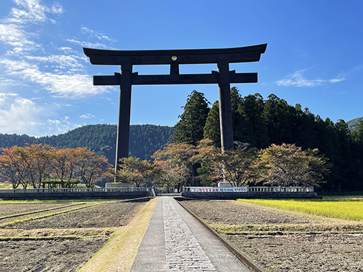
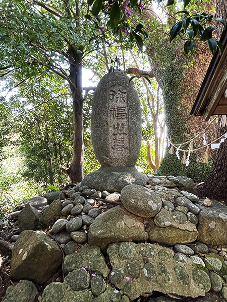
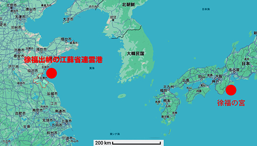
熊野と言えば日本史の精神的背景としての「熊野信仰」が基層であり、その象徴は「熊野三山」と言われる熊野本宮大社、熊野速玉大社、熊野那智大社。現代の「熊野詣」を北海道人として志したワケだけれど、当然のこととしてまずはこの三社に詣ることとして、その最初にこの本宮に向かった。
その程度の予備知識で現地を訪れてはじめて、この現在の本宮社殿は1889年(明治22年)に再建されたものだと言うことを知った。そしてそこではじめて、「それって?」とふと気付いたことがあった。
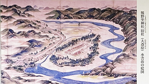
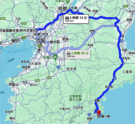
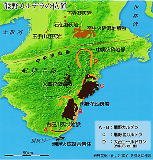
この熊野本宮とほぼ隣接し同じ河川域である奈良県吉野の十津川を1888年に襲った大水害。連動した土砂崩れによって「土砂ダム」が自然形成されたが、その自然堤防が決壊してそれが下流域にあたる熊野本宮旧社殿を潰滅させたのだ。この熊野本宮大社の旧社殿は現在の熊野川(十津川)川原の「大斎原」にあった。
その起点となった大水害を契機として地域の存続自体が危殆に瀕した奈良県十津川の集落から、多くの被災者が北海道の「新十津川」に集団移住した故実がピッタリつき合わさってしまったのです。
知らなかった。
そうであると知ってからは、この現代の「熊野詣」に一種の熱が発生してしまった。熊野と北海道人に太いいのちの糸が見えてしまったのですね。現在の熊野本宮大社社殿の説明看板類を読み下しながら、一気にこころは現在の「大斎原」、熊野本宮旧社殿所在地の方に向かってしまっていた。135年の歳月を経て、北海道人としてのはるかな「巡礼」という心理が沸き起こってしまった。

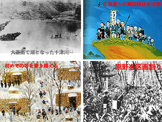
この図集は北海道樺戸郡新十津川町のHPからで町の草創起源を示したもの。大水害によって集落が水没して発生した土砂ダムの様子から始まる、壊滅状態の十津川村落からの「再生」を夢見て2,000kmの距離を集団移住してきた北海道先人たちの記録。奈良県十津川と北海道・新十津川を結ぶいのちの絆の説話は、北海道人として広く知られている。わたしは小学校の時に「社会科」授業でその事実を知った記憶がある。
「そんな苦労があったんだ・・・」と子ども心に痛切な感情を持って受け止めていた。
熊野本宮大社は「よみがえりの地」とされている。まさに再生の神。北海道人のはるかな先人の記憶がわたし自身の内側からも「蘇って」きたように思われてならなかった。まさに再生の地。
熊野本宮大社の社殿は、水害からほぼ1年半程度で高台になる隣接の現在地に再建された。一方の「新」十津川地域では現地近くの監獄囚人労働によって建てられていた住宅(1戸に4世帯同居だったという)に移住後、長くキビシイ冬を越えて、翌春からは原野を開拓して行った。・・・
こうした激甚な災害は日本列島で繰り返されてきたし、まさに現在も能登半島を襲っている。そういうなかから日本人はつねに「蘇って」きた。わたしの中でも熊野信仰が芽生えたのかも知れない。

English version⬇

Kumano Hongu Taisha Shrine and Hokkaido “Shin Totsukawa” Imperial Mythology and Kumano Trip-12
A mess with the fact of Hokkaido mass migration and the great disaster of 135 years ago, which we learned by visiting the site. Revival of the shared memory of the people of the disaster archipelago. …

Kumano is the spiritual backdrop of Japanese history, and is based on the Kumano faith, symbolized by the “Kumano Sanzan” (Kumano Hongu Taisha, Kumano Hayatama Taisha, and Kumano Nachi Taisha). As a Hokkaido resident, I decided to make a modern-day “Kumano Pilgrimage” to these three shrines, and I headed to Hongu as the first stop.
It was only after visiting the site with that level of prior knowledge that I learned that the current main shrine pavilion was rebuilt in 1889 (Meiji 22). Then, for the first time, I suddenly realized, “What does that mean? I suddenly realized something.
In 1888, a major flood hit the Totsukawa River in Yoshino, Nara Prefecture, which is almost adjacent to Kumano Hongu Shrine and in the same river area. The landslides that resulted in the natural formation of a lagoon, which burst its natural levee and destroyed the former shrine of Kumano Hongu, which was located downstream of the river. The former shrine of Kumano Hongu Taisha was located at “Osaibara” on the banks of the present-day Kumano River (Totsukawa River).
The origin of the shrine was the mass migration of many victims from the community of Totsukawa, Nara Prefecture, to “Shin Totsukawa” in Hokkaido, Japan, where the very survival of the community was threatened by a major flood.
I had no idea.
After I learned that this was the case, I felt a kind of fever for this modern-day “Kumano Pilgrimage. I could see a thick thread of life between Kumano and the people of Hokkaido. After 135 years, I felt the urge to make a pilgrimage to the Kumano area as a Hokkaido native.

This collection of illustrations is from the website of the town of Shintotsukawa, Sakabato-gun, Hokkaido, and shows the pioneer origins of the town. Beginning with the lagoons created by the submergence of the village by the heavy flooding, it records the ancestors of Hokkaido who migrated as a group 2,000 km away from the devastated Totsukawa village, dreaming of “rebirth” from the devastating situation. The story of the bond of life that connects Totsukawa, Nara Prefecture, and Shin-Totsukawa, Hokkaido, is widely known as the story of the Hokkaido people. I remember learning about this fact in my elementary school “social studies” class.
I remember learning about it in social studies class when I was in elementary school, and I remember thinking with painful emotion, “I didn’t know such hardships existed….
Kumano Hongu Taisha Shrine is considered the “place of revival. The very god of rebirth. I could not help but feel that the memories of my distant predecessors in Hokkaido were “coming back” to me from within. It is truly a place of rebirth.
The shrine pavilions of Kumano Hongu Taisha were rebuilt on the adjacent hillside about a year and a half after the flood. In the “new” Totsukawa area, on the other hand, after moving into a house that had been built by prison labor near the site (it is said that four families lived together in one house), the people overcame a long and hard winter and cleared the wilderness from the following spring. The following spring, they began to clear the wilderness.
Such severe disasters have been repeated in the Japanese archipelago, and are currently hitting the Noto Peninsula. Japanese people have always been “reviving” from such disasters. Perhaps it is through this that the Kumano faith has sprouted in me.

【季節は真冬本番へ。洞爺湖冬景色】


昨日で今年度の実質第1週が終了。夜には新年会もあって、本日は連載テーマは一時休止。
今週はいろいろなスタートもあったのですが、わたしは取材で伊達方面に行っておりました。久しぶりの北海道内での「遠出」。それも積雪もほぼ例年並み以上になってきた段階。朝早く札幌を出発して、昼過ぎに取材先を退出。そこで、ちょっと寄り道的に、っていうか高速道路を使わずに一般道・国道230号線を利用。
そうすると真冬の洞爺湖の風景がなつかしく、冬の詩情をたたえた表情を見せてくれた。
冬期も氷結しない湖面からは、大気の冷気に向かって水蒸気があがって「霧の風情」。周辺の山々はみんな白く冠雪してくれていて、さまざまな樹木に陰影を描き出してくれている。
札幌の人間にとって、小学校の「修学旅行」の定番はこの洞爺湖。道内でも有数の温泉街は、なんども訪れさせてもらってきた。なので、風景のすべてに余韻があって、時間を復元させてくれる。
しばらく逢っていなかった肉親のようなぬくもり感が伝わってきた。やっぱり北海道は冬の雪景色があらゆる美感で迫ってくる。雪というお化粧は、やはりすごい効果を持っているのだと再認識。女性たちの日々の努力に深く頭が下がってくる思い(笑)。
修学旅行で友だちたちと温泉に浸かってのワイワイガヤガヤの様子が遠雷のように記憶の奥底から湧き上がってくる。ふだんは見たこともないようなお膳料理にキャッキャと大騒ぎ。寝ていたのかどうか、枕投げとかの大騒ぎで、「やべ、先生が来た〜」と布団を大急ぎでかぶる。青春の手前、あどけない少年少女たちの夢舞台。
そこからの帰路。案の定、中山峠までの1時間ほどの行程はときどき視界も定かでなくなるようなブリザードっぷり。なるべく先頭を譲って2〜3番目の走行位置で先行車のテイルランプを案内にしながら慎重に運転してきた。その甲斐あって、中山峠を過ぎたら降雪は終わってくれて、冬道の安定走行。こういったキビシイ条件下では、いっしょに峠を走破した「仲間意識」を一団のクルマ同士ではなんとなく持つ。こういうのも北国人のなにかの共通感情なのだろうか。

走り抜けてきて、札幌の日常的な風景に戻ってくるけれど、そういう中でも普段はやり過ごすような風景美が発見されたりする。「札幌もやっぱり北海道の中の地域なんだ」と今更ながら、気付かせられる。
なんということはない雪中移動なのですが、走馬灯のなかを巡ったような気分。ちょっと元気をもらったような小さな旅でした。

English version⬇

The season is heading into midwinter. Lake Toya Winter Scenery]
Usually, snowfall is a big problem for shoveling, but the raging blizzard is also a background device that restores various memories. A small trip on a public road in winter, no rush, no fuss. A small trip on a public road in winter.

Yesterday marked the end of the first real week of this fiscal year. There was a New Year’s party in the evening, so today’s series theme is on pause.
This week has been a busy one for me, but I was in the Date area for an interview. It was my first “long-distance trip” in Hokkaido in a long time. It was also at a stage when the snowfall was almost equal to or greater than usual. I left Sapporo early in the morning and left the interview site in the afternoon. We left Sapporo early in the morning and left the site a little after noon, so we took a short detour, or rather, we took the national highway Route 230 instead of using the expressway.
The scenery of Lake Toya in the middle of winter was nostalgic and showed us the poetic expression of winter.
The surface of the lake, which is not frozen over even in winter, gives off a “foggy look” as water vapor rises toward the cool air. The surrounding mountains were all crowned with white snow, casting shadows on the various trees.
For Sapporo residents, Lake Toya is a staple of elementary school excursions. I have visited one of the most famous hot spring resorts in Hokkaido many times. So all of the scenery has a lingering quality that restores time to its original state.
I could feel the warmth of the people I had not seen for a while, as if they were my relatives. Hokkaido’s snowy winter landscapes are beautiful in every sense of the word. I was reminded once again that the makeup of snow has an amazing effect. I was deeply bowled over by the daily efforts of the women (laugh).
The sight of my friends and I soaking in a hot spring on a school excursion, laughing and having a good time, rises up from the depths of my memory like a distant thunderstorm. I was so excited to see the dishes that I had never seen in my life. I don’t know if I was sleeping or not, but there was such a fuss about throwing pillows and such, that I would rush to cover myself with the futon and say, “Oh no, the teacher’s here! The dream stage for young, innocent boys and girls on the cusp of youth.
The return trip home. As expected, the one-hour ride to the Nakayama Pass was filled with blizzards that sometimes obscured our vision. We drove cautiously, giving up the lead as much as possible and staying in the second or third position, using the backlight of the car ahead as a guide. Thanks to my efforts, the snowfall ended when we passed the Nakayama Pass, and we were able to drive steadily on the winter roads. Under these difficult conditions, we felt a sense of “camaraderie” as we drove through the mountain pass together. I wondered if this was a common feeling among people from northern Japan.

After driving through the pass, one comes back to the everyday scenery of Sapporo, but even in such a scenic environment, one often finds scenic beauty that one would normally overlook. I was reminded, even after all this time, that Sapporo is still a part of Hokkaido.
It was a simple trip through the snow, but I felt as if I was touring through a running horse. It was a small trip that cheered me up a little.

【徐福伝説を「活かして使う」ニッポン 皇統神話と熊野の旅-11】


さてきのうの続編。徐福伝説という物語自体はあらすじは理解できたのですが、わたし的には、有名な「史記」に記述があるとは言え、なぜそのような中国王朝での説話が日本に根付いたのか?という疑問。歴史書に記載があるとは言え、中国社会ですら永く俗説とされてきたことに、なぜ日本社会は一定の存続根拠を維持し続けたのか、ということですね。
普通に科学的に考えれば、紀元前219年の段階の「航海術」では片道1000kmくらいはある意図的遠洋航海が可能だったとは思われない。はるかに時代を下る唐の時代、日本に仏教を伝えるために「国禁」であった渡航を試みた鑑真の数次にわたる難波例を見てもあきらか。安定的・合理的航海術が存在していたはずがない。仮に渡航事例があったとしてもそれは安定的なものではなく、命からがらの末の偶然であろうし、目的的な結果として渡海が可能だったとは思われない。
ただ、日本は歴史的に東アジアの「フロンティア」的な存在としてたくさんの大陸・半島地域のひとびとにとっての対象地域であっただろうことは事実。現実に日本社会の文化発展はそうした「渡来」によって多くがもたらされること自体は連綿と続いていた。
Wikiで検索すると「徐福伝説」を地域のひとつの継承文化としているのは、この稿で探訪した熊野地域のほかに福岡県八女市、佐賀県佐賀市、京都府伊根町、長野県佐久市、鹿児島県出水市・いちき串木野市、宮崎県延岡市、広島県廿日市市、愛知県一宮市・豊川市、東京都八丈町、秋田県男鹿市、青森県中泊町などに伝承が存在する。多くは「海民」文化が基底にある地域、もしくは関連地域。
上の絵図は歌川国芳画ということで江戸期の浮世絵の題材としてまで登場している。そういう古代浪漫に対して日本人は積極的に受け入れる素地があったということなのでしょう。八百万というきわめて新規受容性の高い地神崇拝が民族的な素地を形成していたというようにも考えられる。
アジア世界の文化中心であった中国王朝の史書にせっかく書き込まれている日本に関連するようなことがらを、ムダにはしないという心理素地なのではと考えられるのですね。活かして使えと。
実際の徐福がどうしたこうしたということよりも、こういった日本人社会の側面、真実性の方がわたし的にはたいへん興味深く考えさせられる。
やはり「旺盛な受容性」の表現であると思えるのですね。
多くの移民者を受け入れ続けてきた社会がその根底に培ってきた柔軟性というようにも言える。四周を海に囲まれた列島社会の基本的な性格として、これをわたしたちは共有しているのではないか。熊野地域では一種の地域特性として歴世、この民族性が色濃く遺り続けたということではないでしょうか?

English version⬇

Nippon “Utilizing” the Xufuku Legend: A Journey to Kumano and the Myth of the Imperial Family – 11
The Japanese people have a mindset of “eight million people” who believe that if such a legend exists, they should make full use of it. Japanese society has cultivated a vigorous receptivity. …

Now, the sequel to yesterday’s article. I understood the outline of the Xu Fu legend, but my question is why such a legend from the Chinese dynasties took root in Japan, even though it is written in the famous “Shiji” (Records of Ancient Matters). I am wondering why such a legend from the Chinese dynasties took root in Japan, even though it is mentioned in the famous “Shiji”. Why did Japanese society continue to maintain a certain basis for its existence when even Chinese society had long regarded it as a myth, even though it was mentioned in the history books?
From a normal scientific point of view, it is unlikely that the “art of navigation” as of 219 B.C. would have been capable of intentional oceanic voyages that were about 1,000 km each way. It is clear from the many cases of Kanjin’s attempts to travel to Japan to introduce Buddhism, which was forbidden by the Japanese government, during the Tang Dynasty, which was a long time later. There is no way that stable and rational navigation techniques could have existed. Even if there had been such a case, it would not have been stable, but would have been a coincidence of a desperate attempt to cross the sea, and it is unlikely that it would have been possible to cross the sea as a purposeful result.
However, it is true that Japan has historically been a “frontier” region in East Asia and a target of many continental and peninsular peoples. In fact, the cultural development of Japanese society has been largely due to the “arrival” of people from other parts of the world.
A Wiki search reveals that, in addition to the Kumano region explored in this article, the legend of Xu Fu is also part of the local cultural heritage in Yame City, Fukuoka Prefecture; Saga City, Saga Prefecture; Ine Town, Kyoto Prefecture; Saku City, Nagano Prefecture; Izumi City and Ichiki-Kushikino City, Kagoshima Prefecture; Nobeoka City, Miyazaki Prefecture; Hatsukaichi City, Hiroshima Prefecture; Ichinomiya City and Toyokawa City, Aichi Prefecture; Hachijo Town, Tokyo Prefecture, Oga City, Akita Prefecture, and Nakadomari Town, Aomori Prefecture. Many are areas where the “sea people” culture is based or related to the “sea people” culture.
The above illustration, painted by Utagawa Kuniyoshi, has even appeared as a subject in ukiyoe paintings of the Edo period. The Japanese people were willing to accept this kind of ancient romance. It is also conceivable that the worship of the earth gods, “Ya-million,” which was highly receptive to new ideas, formed the foundation of the Japanese people’s ethnic identity.
It is thought that this is a psychological background that does not want to waste things related to Japan that are written in the history books of the Chinese dynasties, which were the cultural center of the Asian world. Make the best use of it.
This aspect of Japanese society and its truthfulness is more interesting and thought-provoking to me than what Xu Fu actually did.
It seems to me that this is an expression of “vigorous receptivity.
It could be said that it is the flexibility that has been cultivated at the root of a society that has continued to accept many immigrants. We may share this as a basic characteristic of an archipelagic society surrounded by the sea on all sides. In the Kumano region, this ethnicity has remained strong throughout the ages as a kind of regional characteristic.

【列島各地に遺る中国・秦「徐福伝説」 皇統神話と熊野の旅-10】


能登地震発生後10日を過ぎて実にたくさんの映像情報がもたらされてきている。能登には訪問経験と身体感覚があってまったく言葉もない。震源の珠洲市からはかなり離れた金沢市の北方隣接の「内灘」地域の震災状況には、とくにおどろかされた。道路交通が非常に困難な地域であり未曾有の状況も、わずかずつ徐々に明らかになってくるのだろう。社会の弱いポイントを直撃する震災の恐怖を感じざるを得ない。災害について、住宅建築全体が今後の対応を迫られていくのは間違いない。社会の復元力が試されていくことになるだろう。
さて、きのう書いた「徐福の宮」について、そこに至る道路状況についての体験が強烈で一気に書いたので、肝心の徐福伝説について触れていないことに気付いてしまった(泣)。
ということで遅ればせながら。上の写真のように三重県熊野市波田須の海岸線近くにこの社は特徴的な1本樹木を背景として建てられている。波田須地域全体がまことに狭隘な地形になっているけれど、この御宮はちょっと盛り上がった場所に位置している。
祭神とされているのは中国・秦の時代(紀元前221年に史上初めて中国全土を統一、紀元前206年に滅亡。始皇帝で知られる。)に、始皇帝から「不老不死」の妙薬を探し出す命を受けて、3000人の童男童女による船団を連ねて「東方」に向かったという人物。その荒唐無稽な内容から根拠のない俗説とされてきたけれど、1982年になって中国の江蘇省連雲港市かん楡(かんゆい)県において「徐福」村が発見され徐福が実在の人物として学術研究会で発表された。その後これを契機に秦・漢代の造船所跡などの遺跡も発見されて、当地では徐福生誕の地と情報拡散され観光資源化されてきているという。徐福の出帆、出発は紀元前219年と擬定されているとのこと。


この伝説は不思議なことに日本各地域に徐福伝説として痕跡を残していて、その最たるものが熊野のこの地にあるのだ。今回の探訪の趣旨からは少し外れるけれど、神武帝と同様に「海をわたってきた」説話の骨格は共通するので、興味は持たざるを得ない。歴史作家・安部龍太郎の「半島を行く」には現地で秦代の貨幣も出土した話までも記されている。
熊野地域の中心、新宮市にも「徐福公園」が整備され市のHPにもこの伝承が掲載されている。以下要旨。
〜徐福一行はこの地に自生する「天台烏薬(てんだいうやく)」という薬木を発見しましたが、気候温暖、風光明媚、更には土地の人々の暖かい友情に触れてこの地を永住の地と定め、土地を拓き農耕・漁法・捕鯨・紙すき等の技術をこの地に伝えたと言われます。<中略>日本でも徐福渡来の伝承地がいくつかあり、古くから地域伝承を育み、さまざまな文化が形づくられてきました。特に熊野には徐福渡来の地として数々の伝承・史跡が残り鎌倉時代には文献に出てきます。〜
紀元前219年当時と言えば、日本は弥生時代。もちろん文字記録などはない時代。真贋はもちろん定かではないけれど、どうして熊野にはこういった伝承が根付くのか、不思議な符合と言わざるを得ない。

English version⬇

The Legend of Xu Fu” in Qin, China, which remains in various places in the archipelago.
Yesterday, I forgot to write about the important Xu Fu legend. The legend of Xu Fu, which dates back to 219 B.C. in the Qin Dynasty of China, has been preserved as a palace in Kumano. The palace is located in Kumano.

It has been more than 10 days since the Noto earthquake and a lot of visual information has come in. I have been to Noto before and have no words to describe it. In particular, I was astonished by the earthquake situation in the Uchinada area, which is located in the northern part of Kanazawa City and is quite far from the epicenter of the quake in Suzu City. Road traffic is extremely difficult in this area, and the unprecedented situation will probably become clearer gradually. One can’t help but feel a real sense of fear about the disaster. There is no doubt that housing construction as a whole will be forced to respond to the disaster in the future. The resilience of society will be put to the test.
I wrote about “Xufu’s Palace” yesterday because I had such an intense experience of the road conditions leading to the palace that I realized I had not mentioned the Xufu legend, which is the most important part of the story (tears).
So, I am late to the party. As you can see in the photo above, this shrine is built near the coastline in Hadasu, Kumano, Mie Prefecture, with a distinctive single tree in the background. The entire Hadasu area has a very narrow topography, but this shrine is located on a slightly elevated site.
The shrine is dedicated to the god of worship during the Qin Dynasty in China (known for the first unification of China in 221 B.C., followed by the fall of the Qin Dynasty in 206 B.C., and the first emperor of the Qin Dynasty, Shi Huangdi). It was destroyed in 206 B.C., known as the First Emperor of China). In the Qin Dynasty (221 B.C., the first time China was unified in 221 B.C., and it was destroyed in 206 B.C.), a fleet of 3,000 men, women, and children headed for the East in search of a miracle medicine that would make them immortal. Although this wild and ridiculous story has been considered a myth with no basis in reality, in 1982, a village named “Xu Fu” was discovered in Kanyu County, Lianyungang City, Jiangsu Province, China, and Xu Fu was announced as a real person by an academic research group. This led to the discovery of the ruins of shipyards and other relics from the Qin and Han dynasties, and information about Xu Fu’s birthplace has been spread in the area, making it a tourist resource. It is believed that Xu Fu set sail and departed in 219 B.C.

Curiously, this legend has left traces in various regions of Japan as the legend of Xufuku, the best example of which is found here in Kumano. Although it is a little out of the scope of this visit, it is of interest because, like the legend of Emperor Jinmu, it shares the same framework of the “crossing the sea” legend. In his book “Going to the Peninsula,” history writer Ryutaro Abe mentions that coins of the Qin dynasty were also excavated in the area.
In Shingu City, the center of the Kumano region, a “Xufuku Park” has been established, and the city’s website also carries this legend. The following is the gist of the story.
〜It is said that Xu Fu and his party discovered a medicinal tree called “Tendayaku,” which grew wild in this area, and that the warm climate, scenic beauty, and warm friendship of the local people made this place their permanent home, where they cultivated the land and introduced farming, fishing, whaling, paper making, and other skills to this area. <In Japan, there are several places where Xu Fu has been handed down from generation to generation, and local traditions have been nurtured and a variety of cultures have been formed since ancient times. In Kumano, in particular, there are numerous legends and historical sites that can be traced back to the Kamakura period (1185-1333), and the story of Xufuku’s arrival can be found in literature. 〜The first time in 219 B.C.E.
In 219 B.C., Japan was in the Yayoi period. Of course, there were no written records. Although the authenticity of this story is not certain, it is a curious coincidence that this kind of folklore has taken root in Kumano.

【三重県熊野市波田須町・徐福の宮 皇統神話と熊野の旅-9】


 きのうから仕事開始で本日はさっそく出張外出日程。ですがブログは絶対に更新するぞ、という意気込みで書き続けたいと思います。最近、認知症の疑いと言われた方のお話しを聞いたのですが、とくに地理的な感覚が衰えて、あたらしい住所・場所に到達することがきわめて困難になるのだと。
 へぇ〜と驚かされた。このブログでご紹介している全国各地の探訪には当然、常にあたらしい目的地を設定してカーナビを操作して向かうというのがわたしの常態。それに伴って当然、地理認識は錬磨されざるを得ない。方向感覚・距離感の複合された認識能力が常に活発に働らかされる。
 わたしの場合、こうした新規探訪欲求が強く「なんでもみてやろう」みたいな好奇心のかたまり(笑)。その方のお話しを聞き、いても立ってもいられず、またあちこち探訪せねば、と意を強くした次第。その動機として日々のブログ記述はたいへん役立っているので、健康維持にも最重要でしょうね。
 で、本日は行き着くまでにまれに見る苦労をした「徐福の宮」探訪篇。
 上の写真はやや高台に位置する熊野市波田須町の国道311号線から「徐福の宮」の目印である一本木を見下ろしたショット。看板も設置してあった。
 ところが、その看板付近にある「道路」らしきものは、国道から急角度で下って、すぐに曲がりくねるという超難路。北海道の常識感覚ではありえないほどの1車線道路で、しかも路側の石もないという、はじめて訪れた人間の進入を拒むような道でありました。何度見返してみても「これはムリ」。

 詳細地図がこちらですが、徐福の宮の左上ポイントになります。一応,道路にはなっているけれど、細い道を急降下してしかも左折する様子がお分かりいただけるでしょうか。
 「これはなにかの間違いだろう、ありえない」と考えたのですが、そういう間違いの標識をわざわざ国道沿いに設置することはないでしょう。途方に暮れ半分は探訪を諦めて、通り過ごそうかと思ってその場所を離れて、地図上で左手方向にクルマを移動させた。そうしたら運良く地元の方と遭遇。はじめての訪問者にとってそれなりにわかりやすい道順をお聞かせいただいた。「まぁ、だいたい道なりに行けばなんとか」みたいなお話しでした。
 で、目的地からはいったん遠く離れ、地図左端のポイントからうねうねと描かれたクルマ1台がやっとの坂道を下っていった。北海道人として本州地域の街路の狭さはイタいほどに知っているので、クルマは軽もしくはコンパクトカー一択。このときも幸い、軽だったのでなんとかハンドルを操作できた次第。
 それにしても先ほどの案内道とは違って急角度ではないけれど、1台やっとでしかも路側石もない坂道・・・。それも曲がりくねっているので、位置感覚はまったく摑みにくい。カーナビもあまりの難路ぶりで案内機能不全に陥っていた。というか、見るゆとりはとてもない。
 引き返すことも困難なこの状況の時に地元の「郵便配達員」の方と遭遇。先ほどの方と同じお答えでしたが、こちらとしてはそこそこ力強いアドバイスと勇気が出ました、感謝。
 最後は「ここにしか駐車できない」と言われた駐車場を発見できてなんとかクルマを停め、目印の一本木をめがけて歩いて、ようやく現地に到達できた。
 自分の地理認識能力が究極的に鍛えられる困難に耐えた、と言えるでしょうか。まだ認知機能低下はなく挑戦心は元気、若い!(笑)。
 ふ〜、疲れた。以降の現認報告はあしたへ。

English version⬇

Xufuku no Miya, Hadano-cho, Kumano City, Mie Prefecture: A Journey to Kumano and the Myth of the Imperial Lineage-9
Aging decreases cognitive function. Geographical recognition is the most prominent factor in dementia. From walking on a mountain road in Tategasaki to a narrow slope that is difficult to drive on. …

I started work yesterday, and today I will be out of town on a business trip. However, I am determined to keep writing this blog. Recently, I heard a story about a person who was suspected to have dementia, especially geographical sense is deteriorated and it becomes extremely difficult to reach a new address or place.
I was surprised. Whenever I visit the various places in Japan that I introduce in this blog, I always set a new destination and use the car navigation system to get there. This naturally requires me to improve my geographical awareness. My combined sense of direction and distance is always actively exercised.
In my case, I have a strong desire to explore new places, and I have a mass of curiosity like “I’ll try anything” (laugh). Hearing this person’s story, I couldn’t stand still, and I felt strongly that I had to explore again. My daily blog entries have been very helpful in motivating me to do so, which is probably the most important thing for me to do to maintain my health.
Today, I would like to introduce you to “Xufu’s Palace,” which was one of the most difficult places I ever visited before I arrived there.
The photo above is a view looking down on Ippongi, the landmark of “Xufuku no Miya,” from Route 311 in Hadasu-cho, Kumano City, which is located on a slightly elevated plateau. A signboard was also in place.
However, what appeared to be a “road” near the sign, however, was an extremely difficult road that descended at a steep angle from the national highway and then quickly curved around. It was a one-lane road, which is impossible in the common sense of Hokkaido, and there were no roadside stones, so it was the kind of road that first-time visitors would refuse to enter. No matter how many times I looked back at it, I thought, “This is impossible.

The detailed map is shown here, at the upper left point of the Xufu Palace. You can see that the road is a road, but it is a narrow road with a sharp drop off and a left turn.
I thought to myself, “This must be some kind of mistake, it can’t be,” but I would not have bothered to place such a wrong sign along the national road. At a loss, I gave up halfway and moved my car to the left on the map, thinking that I would pass by the place. As luck would have it, I ran into a local. He gave me directions that were reasonably easy to follow for a first-time visitor. He said, “Well, if you follow the road, you should be able to make it.
Once far from our destination, we started from the point on the left edge of the map and headed down a winding road that was barely enough to accommodate one car. As a person from Hokkaido, I know how narrow the streets are in the Honshu area, so I had to choose a light or compact car. Fortunately, the car was light, so I was able to maneuver the steering wheel.
Unlike the previous guideway, the slope was not steep, but it could barely accommodate one car, and there were no roadside stones. It was also winding, so it was difficult to get a sense of where we were. The car navigation system was also not functioning properly due to the difficulty of the road. In fact, there was no time to look at it.
It was at this point that we encountered a local “mailman,” who gave us the same answer as the previous person. He gave us the same answer as the previous person, but he was able to give us some powerful advice there.
Finally, we managed to find a parking lot where we were told that we could only park here, parked our car, and walked toward the landmark Ippongi tree to finally reach the site.
I guess you could say that I endured a real-life difficulty that ultimately trained my geographical awareness. I am still young.
I am tired. I’ll report on the next day.

【楯ヶ崎を目途に神武帝、二木島上陸? 皇統神話と熊野の旅-8】


途中でシカさんと出会って、ゾッコンにさせられた(笑)この楯ヶ崎行き。どんなイキモノもその動作表情には「神がかった」ものがある。自然の摂理に沿ったイキモノとして当然。その出会いの瞬間のタイミングで「こころに残る」ということがある。たぶん恋情とも通じるものでしょうね。抗いがたい好意が芽生えるような瞬間というものがあるのでしょう。
日本文化ではなぜか奈良のシカたちがその象徴のようになっていく。神鹿。奈良春日大社の祭神、武甕槌命(タケミカヅチノミコト)は鹿島神宮(茨城県)から神鹿に乗ってきたと伝わる。鹿は神の使いとして古くから手厚く保護された。わたしは偶然、楯ヶ崎で自然のシカに出会ってしまった(笑)。だからということではないけれど、事実の背景部分で徐々に神武東征経路への「さもありなん」感プッシュ気味。
タケミカヅチノミコトは神代に国譲りの主役となり、さらに古事記ではこの神武東征上陸時にも高倉下(たかくらじ)という人物に神託を与え神武天皇に霊剣布都御魂をもたらしたとされる。
ともあれ、今次の熊野行は永くナゾと思っていた神武東征という皇統神話への探索旅。きわめて重要な上陸地に関しての実体験を得ることが中心軸です。ひとつの有力説として楯ヶ崎を海路上の目印・目途とした東征船団はその近隣の適地・良港として二木島湊に上陸したとされる。途中、神武帝の兄2人を海難で失いながら、上陸を果たしたとされるのですね。


図は橿原神宮の「神武天皇東遷の奇跡」からで、その下の港湾航空写真は三重県のHPより。図の「荒坂の津」というのが二木島と擬定されている。そこから吉野まで「八咫烏」の先導で山路を踏破していく。そして大和平定の大戦略「日を背に負って敵を制圧する」作戦展開していったという。
この大戦略は、壬申の乱でも関ヶ原でも日本史を貫いている成功戦略のようにも思える。
わたしの興味としては歴史と神話の狭隘部分についての探究心ということ。
まずは、熊野信仰というものの文化的側面を受容しつつ、日本文化のある部分を象徴している皇統神話について身体感覚を持ちたいということになるワケです。
今回までの探索では、熊野という紀伊の狭隘地域が大規模なカルデラを地形根拠にしていることが明確にわかった。そしてその異形な地形と皇統神話が強く結びついていることも体感できた。このことは、大づかみの認識として間違いがないでしょう。楯ヶ崎の柱状節理は雄弁だと思う。
そして異形の地形が日本文化に特徴的な自然崇拝・修験道などの積層があって、やがて神仏習合というように精神文化が形成されていくとき、熊野はこの精神文化の「聖地」化されていったのでしょう。それが歴史事実かどうかは別として、精神文化として色濃く堆積していったことは事実。
そのあたりの日本精神文化とはやや遠い世界標準的歴史時間を刻んできている北海道人としては、ある意味新鮮な感覚を持って体感させられているところです。

English version⬇

The Emperor Jinmu landed on Nigijima with Tategasaki as his goal? The Imperial Mythology and Kumano Journey-8]
A search for the myth surrounding Arasaka-no-tsu, the point of landing in Kumano during the Jinmu expedition to the east. As a Hokkaido resident, I would like to experience the narrow point between faith and truth. …

On the way to Tategasaki, I met Shika-san, who made me fall in love with him (laugh). Every animal has a “godlike” expression in its movement. It is natural for any creature to have a “divine” expression. The timing of the moment of encounter is what makes it “memorable. Perhaps it is the same with love. There must be a moment when an irresistible affection develops.
In Japanese culture, for some reason, the deer of Nara have become a symbol of this. The “sacred deer”. Takemikazuchi-no-mikoto, the deity of the Kasuga Grand Shrine in Nara, is said to have ridden a sacred deer from the Kashima Shrine (Ibaraki Prefecture). Deer, as the messengers of the gods, have long been heavily protected. I happened to meet a natural deer in Tategasaki (laughs). (Laughs.) Not necessarily because of that, but the background of the fact is gradually pushing the “so it goes” feeling toward the route of the Jimbu expedition.
Takemikazuchinomikoto played a leading role in the handing over of the land to the Emperor in the divine era, and according to the Kojiki, he gave an oracle to a man named Takakura-ji when he landed on the eastern coast of Japan to bring the sacred sword Futo-mikoto to Emperor Jinmu.
In any case, this next trip to Kumano is a journey of exploration into the mythology of the imperial lineage of the Jinmu expedition, which has long been a mystery to us. The central axis of this trip is to gain firsthand experience of the most important landing sites. One popular theory is that the expeditionary fleet, which had set its sights on Tategasaki, landed at Futakishima Minato as a suitable location and good port nearby. It is said that they made landfall while losing two of Emperor Jinmu’s elder brothers in maritime accidents along the way?

The figure is from “The Miracle of Emperor Jinmu’s Eastward Transition” at the Kashihara Jingu Shrine, and the harbor aerial photo below it is from Mie Prefecture’s website. The “Arasaka-no-tsu” in the figure is identified as Futakijima. From there, “Yatagarasu” led the way through the mountains to Yoshino. They then developed a grand strategy to conquer the enemy with the sun on their backs in order to pacify Yamato.
This grand strategy seems to be a successful strategy that has been followed throughout Japanese history, both in the Jinshin Rebellion and in Sekigahara.
My interest is to explore the narrow point between history and mythology.
First of all, I would like to have a physical sense of the mythology of the imperial lineage, which symbolizes a certain part of Japanese culture, while accepting the cultural aspects of the Kumano faith.
In this exploration, it has become clear that Kumano, a narrow region in Kii, is based on a large caldera. We have also experienced the strong connection between the unusual topography and the myth of the imperial lineage. There is no doubt about this as a general understanding. I think the columnar joints of Tategasaki are eloquent.
And when the oddly shaped topography was layered with nature worship, Shugendo, etc., characteristic of Japanese culture, and eventually spiritual culture was formed, as in the Shinto/Buddhist syncretism, Kumano must have been made a “sacred place” for this spiritual culture. Whether this is a historical fact or not, it is a fact that the spiritual culture has been strongly deposited in Kumano.
As a Hokkaido resident who has lived in a world-standard historical time that is somewhat distant from the Japanese spiritual culture, I am experiencing it with a fresh sensation in a certain sense.

【異形の自然と「ひとりきり」で出会う 皇統神話と熊野の旅-7】


世界遺産“紀伊山地の霊場と参詣道” は2004年の指定と言うこと。道の世界遺産ということではキリスト教世界のスペイン、フランスにまたがる「サンティアゴ・デ・コンポステーラの巡礼路」と2つだけ。この楯ヶ崎は伊勢路の周辺に位置することになる。
自然造形はそれこそ熊野地域一帯にその美感を見せている。そういう美感の中にいると神がそこに宿っているとごく普通に感得するものなのだろうか。北海道の地に産まれ住んでいる身からすると、この近畿地方にこうした自然造形での感動地域が広く存在していることに新鮮なよろこびを感じる。古格をまとったはるかな先人と出会うようなちょっとうれしい感覚と言えるだろうか。
さてはじめて歩く楯ヶ崎への自然林道から、一瞬、木陰越に見えたのが上の写真。「おお、これが楯ヶ崎か、なぁ?」「すこし見え方、違うような?」と思ったけれど、その下の現地「案内図」分岐点からさらに上った尾根の位置からだったのでとっさには楯ヶ崎と思った。だけれども後で確認したら、どうも無名の崖面のよう。地図写真上にわたしが白い矢印を付けた楯ヶ崎のとなりの崖面。うーむ、紛らわしい(笑)。
きのう、途中で出会ったシカのことを書いたけれど、きのうなにげにNHKの奈良に取材した歴史番組中に春日山のシカの画像があって、ついスマホを向けていた。楯ヶ崎への道中で出会ったシカさんの後ろ姿の様子とまったく同じような体勢だった。個人的な体験って少し美化されて印象に残っていくのだなぁと実感。シカさんへの愛情が強くなってきている。背景は奈良の市街地なのでその辺は大違いですが。おっと横道。

ときどき左手にチラチラと上の断崖が見え隠れするのですが、道は角度が振れていってやがて視界からは消えていくほどに林道を進まされる。「あれ、さっきの断崖良かったのに、どうなるのかなぁ」とやや混乱しながら先へ先へと、道はわたしに「引導を渡して」くる。う〜む、しょがない。

そんなわたしの不安な心理を見透かしたように、やがて一気に視界は広々とした太平洋の岸壁上に開放されていく。眼下には押し寄せる波が渦を巻いているような景観。
どうも手前側は地図で書かれている「千畳敷」の一部のようです。「灯台」は右手手前側に確認することができました。


そうするとと視線を左手に向けたら、朝日を逆光に浴びながら、黒々とした「楯」状の岩塊が見えてきました。片道1.9kmと言いながら、アップダウンといろいろな風景景観を目に焼き付けさせられた末の目的地であります。ふ〜、ずいぶんと迷わせられたけれど、見ていた写真通りの外観形状。しかしこの時期の朝にはここまで逆光になってしまうのかと、ここまで来てようやく「誰もいない」理由がわかった(笑)。
でもまぁそんな繰り言は、きれいさっぱり汗がひいていくように消えていった。

English version⬇

Encountering the Unusual Nature “Alone”: Imperial Mythology and Kumano Journey-7
During this early morning visit to Tategasaki, I did not encounter any human beings. The journey where the inner world encounters all the phenomena of nature with its bare skin. …

The World Heritage Site “Sacred Sites and Pilgrimage Routes in the Kii Mountain Range” was designated in 2004. There are only two World Heritage sites along the road: the pilgrimage route of Santiago de Compostela in Spain and France, which straddle the border between the Christian world. Tategasaki is located on the periphery of the Ise Road.
The natural formations show their beauty all over the Kumano area. When you are in the midst of such beauty, it is quite normal to feel that God resides there. As someone who was born and lives in Hokkaido, I feel a fresh sense of joy at the fact that there is such a wide area of inspiring natural formations in the Kinki region. I guess you could say that it is a little like meeting a distant predecessor clad in ancient dignity.
From the natural forest road to Tategasaki, which I walked for the first time, I saw the photo above for a moment over the shade of the trees. “Oh, is this Tategasaki? It looks a little different, doesn’t it? I thought it was Tategasaki, but it was located on the ridge further up from the junction of the local “guide map” below, so I immediately thought it was Tategasaki. However, when I checked later, it seemed to be an unnamed cliff face. The cliff face next to Tategasaki, which I marked with a white arrow on the map. Hmmm, it is confusing (laugh).
Yesterday, I wrote about the deer we met on the way to Tategasaki, but yesterday I saw an image of deer in Kasuga-yama in NHK’s history program on Nara, and I couldn’t help pointing my phone at it. The deer we met on the way to Tategasaki was in the exact same posture as the deer we saw on the road to Tategasaki. I realized that personal experiences are a bit beautified and leave a lasting impression. My affection for the deer is getting stronger. The background is the urban area of Nara, though, so there is a big difference in that area. Oops, a side road.

Sometimes I would glimpse the cliff above me on my left, but the road would swing in an angle and eventually disappear from view as I was forced to continue on through the woods. I was a little confused, wondering what was going to happen to the cliff that was so nice earlier, but the road kept “leading” me onward. I was wondering what was going to happen to me.

As if seeing through my anxious state of mind, my view was soon opened up to the wide expanse of the Pacific Ocean. Below me, the view is like a whirlpool of surging waves.
Apparently, the foreground is part of the “Senjojiki,” as described on the map. The “lighthouse” could be seen on the front right.

Then I turned my gaze to the left and saw a dark “shield” shaped mass of rock backlit by the morning sun. Although it was only 1.9 km one way, this was our destination after having our eyes burned by the ups and downs and the various landscapes. Well, we got lost for a long time, but the exterior shape was just as I had seen it in the pictures. However, I finally understood the reason why there was no one here, as I wondered if it would be so backlit in the morning at this time of the year (laugh).
But, well, that kind of nonsense disappeared as if I was sweating.

【楯ヶ崎へ国道脇駐車場から林道4km 皇統神話と熊野の旅-6】


さて北海道から熊野のひとつの象徴としての楯ヶ崎への道。往古の神武東征の重要な故地であり、その後の中世での上皇たちによる「熊野詣」でも、当然行脚したことが考えられる。そういった「高名」な場所なので現代においては、相当「観光開発」されているものと漠然と想像していた。
しかし交通状況を調べるほどに熊野地域全体としてあまり利便性は高くはないことは薄々感じていた。それでもそれなりに開発されているものと思い込んでいた。前日宿泊した旅宿で「楯ヶ崎に行くのです」と申告したときの地元の人としての反応も意外そうであり、「ん?」とは思っていた。
ということで翌朝、クルマで30分ほど走って国道311号線の脇の「楯ヶ崎」駐車場に。最初は「あ、なんかちっちゃい駐車場があるな」とは思ったが、あまりな意外さで通り過ぎてしまった。そこから数分走ったら、反対側車線側にそこそこの駐車場。しかし、高名な観光スポットという刷り込みがあったのでそこもスルーしてさらに先へ向かった。行けども行けどもなにもない・・・。
「そうすると・・・」と、ようやく「観光地」概念への疑念が湧いてきて引き返すことにした。そこまで人影も見えなかったのだけれど、ようやく地元の方が早朝散歩されているのとすれ違うことができて楯ヶ崎について尋ねることができた。・・・あの「ちっちゃい駐車場」が目的のスポットだという。目的の楯ヶ崎はそこから山道の自然道を片道1.9km歩いた先にあるのだと判明。
その段階でようやく、この紀伊半島・熊野地域という実像が感得できはじめてきた。
事前にはこの楯ヶ崎探訪についての安部龍太郎の「半島をゆく」を読んでいたのだけれど、その記述以上に「北海道っぽい」ことがわかってきてしまったのですね。安倍さんはわたしより3つほど年下だけれど、体力的にかなりキツかったと記述されていた。「あれはホントだったのか」という迂闊な気付き(笑)。
まぁそれでも普段から早朝散歩で往復4km程度は札幌の円山周辺地域を歩いているので、体力的には問題はない。よし行くぞ。

この山道はまことに自然そのまま、リアス式海岸地形がそのまま残されていて、起伏と変化に満ちている。途中には湾入りして海岸に出る。そこに「阿古師神社」があって、その機縁も知っているので、参拝させていただいたあと、さらに半島部の山岳地形のなかに分け入っていく。
ほぼ無心で道標のままに歩いていて、ふと気付いたら野生のシカの後ろ姿と5-6m至近で遭遇。
森の中での突然の遭遇であります。あまりに咄嗟だったのでスマホ写真にまでこころが回らなかった。ただ気付いてカメラを向けたら、シカは早々に気付いて去って行ったことでしょう。この遭遇はまったくの一瞬の静寂なイキモノ同士の出会い。
シカの方でもこちらに気付かなかったようで、かれはかれの棲息する普段の環境の中で、静寂な心理のままに自然と一体になって呼吸していると感じた。札幌円山で出会う野生動物はリスや野鳥などで、ここまで大型の動物と出会うことはない。もしあるとすればそれはヒグマ。札幌以外ではクルマに乗っていてシカと遭遇することはあるけれど、こちらもカラダひとつだけの素肌感覚で遭遇するのははじめて。
こちらが「お邪魔」していることは明らかだけれど、かれがわたしに気付かないようには、この時わたしも自然と無心に同期していたのだろうかと、なぜか少しうれしかった。自分でも不思議な心理ですね。

そして楯ヶ崎、熊野の「地域の空気感」がこのとき一気にカラダに染み込んで来た。

English version⬇

4 km of forest road from the parking lot by the national road to Tategasaki [Imperial Mythology and Kumano Trip-6].
Due to a spur-of-the-moment encounter, I was unable to photograph the deer in the forests of Kumano. The deer I encountered in the back were quite naturally divine. …

The road from Hokkaido to Tategasaki is one of the symbols of Kumano. It was an important place for the ancient expedition of the ancient Japanese emperor Jinmu to Kumano, and it is thought that the emperors of the Middle Ages naturally traveled to Kumano on their pilgrimages. Since it is such a “famous” place, I had vaguely imagined that it had been developed as a tourist destination in modern times.
However, the more I investigated the traffic situation, the more I realized that the Kumano area as a whole was not very convenient. Even so, I assumed that the area had been developed to a certain extent. When I told the inn where I had stayed the day before that I was going to Tategasaki, the reaction of the locals was not surprising. I had thought so.
So the next morning, I drove 30 minutes to the “Tategasaki” parking lot off Route 311. At first I thought, “Oh, there is a tiny parking lot,” but I passed by it because it was so unexpected. After driving for a few minutes, I found a parking lot on the opposite side of the road. However, I had an impression that it was a well-known tourist spot, so I passed it and headed further on. I kept going and going, but nothing.
I finally began to doubt the concept of a “tourist spot,” and decided to turn around. I didn’t see any people, but finally I passed a local walking early in the morning and he asked me about Tategasaki. He told me that the “tiny parking lot” was the spot I wanted to visit. It turned out that our destination, Tategasaki, was 1.9 km away from there on a mountain nature trail.
At this point, I finally began to get a sense of the Kii Peninsula and the Kumano area.
I had read Ryutaro Abe’s book, “Peninsula on the Way,” about his visit to Tategasaki, but it turned out to be even more “Hokkaido-like” than Abe’s description. Abe is about three years younger than I am, but he described the trip as physically demanding. I realized that I had been careless and wondered if it was true (laugh).
But I usually take an early morning walk of about 4 km round trip in the Maruyama area of Sapporo, so I have no problem physically. So, I’m going to go.

This mountain road is truly natural, with the rias coastline remaining as it is, full of ups and downs and changes. The path leads to a bay and then to the coast. There is a shrine called “Akoji Shrine” there, which I know the connection to, so after paying my respects, I continued on into the mountainous terrain of the peninsula.
I was walking almost mindlessly, following the signposts, when I suddenly realized that I had encountered the back of a wild deer at a distance of 5 to 6 meters from me.
It was a sudden encounter in the forest. It was so sudden that I didn’t even think to take a picture with my phone. If I had just noticed it and pointed my camera at it, the deer would have noticed it and gone away. This encounter was a totally momentary encounter between two quiet creatures.
Even the deer did not seem to notice us, and I felt that he was breathing as one with nature in his usual habitat, with a tranquil mind. Wild animals encountered in Maruyama are squirrels, wild birds, etc., and we never encounter such large animals. If there is such a thing, it is a brown bear. Outside of Sapporo, I have encountered deer while riding in a car, but this was the first time for me to encounter a deer with only my body against its skin.
It was obvious that I was “intruding” on him, but for some reason I was a little happy, wondering if I had been in sync with nature and mindless, as if he had not noticed me at the time. It’s a strange psychology even for me.

And the “local atmosphere” of Tategasaki and Kumano soaked into my body at once.

【北海道から神武東征の楯ヶ崎へ 皇統神話と熊野の旅-5】


楯ヶ崎という景観の写真は上のようにWEB上で確認することができる。北海道の層雲峡などでよく見ている「柱状節理」地形がそのまま海中からそそり立っていると事前には感じられていた。
神武東征という皇統の成立にとっての歴史的結節点のことを北海道にいて考えて続けていた。一回現地を見てみたい、古代史のナゾ、日本の国の始原のカタチを構成した「国体のルーツ」を確認したいと念願したワケ。他用もあったけれど、主にこのことを眼目にして北海道を旅立った。その時間を持てるようになったことに深く感謝しながら。
日本列島37,000年史という見方では、ながく縄文的な狩猟採集の時代が続き、大きな食物採集要素として海生動物の摂取が基盤を形成していた。日本海側地域だけではなく太平洋側海岸地域でも同様に適地「開発」されていたに違いない。それが弥生以降、稲作農業が国土全域に拡大しその適不適によって開発偏差が進行したことだろう。
日本皇室の成り立ちにとって、稲作文化の主導者という側面は強かったのだと感じる。アマテラスが皇祖神であることは稲作農業の最大の守護神が太陽神であることを示しているし、天皇は農業歳事について田植えなどを行うことが知られて、繰り返し国民に広報拡散されている。
北海道がながく日本国家から化外扱いされてきたことはこうした国の成り立ちも関わっているのだろう。日本の国体が中華的権威主義国家とか、あるいはロシア的な狩猟採集型独裁国家であれば、北海道島へのこのような歴史的・伝統的な距離感はなかったのではないか。ロシア皇帝型権力であれば間違いなくすぐに領土化しただろう。
話がそれ気味(笑)。ともあれ、北海道から熊野・楯ヶ崎はとにかく遠い。
旅程の関係から大阪伊丹空港に降りて神戸空港から北海道に帰ることになった。大阪からは伊勢路を通るか、紀州路を通るか迷うけれど、高速道路の利便性などを考えて伊勢路となった。日中時間に途中にいくつかのポイントも経由して寄り道できるのでその利便性もあった。なので楯ヶ崎になるべく近い場所で夜に到着・宿泊して、元気いっぱいの状態で早朝から山道往復4kmを踏破したいと考えたのであります。あ、もちろん移動はレンタカー。


写真は宿泊した「勝三屋」さんの様子。三重県尾鷲市梶賀町ということで楯ヶ崎へ向かうには伊勢路ルートとしてはいちばん近そうだったのですね。途中数カ所寄り道した後だったので、現地到着は夜の8時ころ。着いてみて初めて、こちらが漁港に面していて「釣り人」御用達系だということを知った(笑)。
ご主人は漁師さんで釣り人をスポット箇所に送迎されたりしていて、奥さんが接客食事などをやっているという「家庭的」な雰囲気。楯ヶ崎のいちばん近い宿泊施設という当方の選択基準は、現地としては「へぇ〜」という勘違いぶりでした(笑)。まぁそういうのも旅の面白さ、ではありますね。 <長くなったので以下、あしたへ>

English version⬇

From Hokkaido to Tategasaki, the site of the Jimmu expedition to the east, a trip to Kumano and the myth of the Imperial lineage -5
Arriving in Osaka, we took the Ise route to Kumano Tategasaki. After several stops along the way, the nearest inn was reserved for sea anglers. A modern-day Kumano pilgrimage to a nearly extinct land (laugh). The first time I went to Ise…

Photos of the Tategasaki landscape can be found on the web as shown above. I had a preliminary impression that the “columnar jointed terrain” often seen in Sounkyo and other places in Hokkaido was rising directly out of the sea.
While in Hokkaido, I kept thinking about the historical node for the establishment of the imperial lineage, the Jimmu expedition. I wanted to visit the site, to see the mysteries of ancient history, and to confirm the roots of the kokutai, which constituted the original form of the nation of Japan. Although I had other plans, this was the main purpose of my trip to Hokkaido. I am deeply grateful that I now have the time to do so.
The 37,000-year history of the Japanese archipelago shows a long period of Jomon-like hunting and gathering, based on the consumption of marine animals as a major food-gathering element. Not only the Sea of Japan coast region, but also the Pacific coast region must have been “developed” in the same way. After the Yayoi period, rice agriculture expanded throughout the country, and development deviations probably progressed according to the suitability of the land.
I feel that the leadership of rice culture was a strong factor in the formation of the Japanese imperial family. The fact that Amaterasu is the ancestral deity of the emperor indicates that the sun goddess is the greatest guardian deity of rice agriculture, and the emperor is known to perform agricultural events such as rice planting, which is repeatedly publicized and spread among the people.
The fact that Hokkaido has long been treated as an outcast by the Japanese nation may have something to do with its origins. If Japan had been a Chinese-style authoritarian state or a Russian-style hunter-gatherer dictatorship, this historical and traditional distance from the island of Hokkaido would not have existed. A Russian czarist-type power would certainly have made it a territory immediately.
This is a bit off topic (laughs). Anyway, Kumano and Tategasaki are far from Hokkaido.
Due to our itinerary, we had to get off at Osaka Itami Airport and return to Hokkaido from Kobe Airport. I was torn between taking the Ise-road or the Kishu-road from Osaka, but decided to take the Ise-road considering the convenience of the expressway. We also had the convenience of being able to stop at several points along the way during the daytime. Therefore, we wanted to arrive and stay at a place as close to Tategasaki as possible at night, and start the 4-km round trip on the mountain road early in the morning with full of energy. Oh, and of course, we rented a car for transportation.

The photo shows the “Katsumiya” where we stayed. The hotel is located in Kajiga-cho, Owase City, Mie Prefecture, so it was the closest Ise route to Tategasaki. We arrived there around 8:00 p.m. after making several stops along the way. It was only after we arrived that we learned that the restaurant faced a fishing port and was frequented by “fishermen” (laugh).
The owner is a fisherman who takes anglers to and from the spot, and his wife is in charge of serving customers and making meals. Our selection criterion was that it was the closest accommodation to Tategasaki, but we were mistaken. Well, that’s the fun of traveling, isn’t it? <(Laughs.) It’s a long story, so I’ll leave it for tomorrow.

【カルデラ地形と古代の信仰心 皇統神話と熊野の旅-4】


熊野地域の中心都市・新宮市は特異な地形と歴史年代での「熊野信仰」という独自の文化性についての研究を促進するために「熊野学」というカテゴリーを立ち上げ、公共自治体として学会などの活動をバックアップしている。こちらがそのHP。
大阪の伊丹空港で「熊野に行くんです」とレンタカー屋さんで車を借りるときスタッフの若い方に言ったとき「熊野ってどこですか?」と問い返された。京阪神地域ではそういう認識なんだと知らされた。言外に「わざわざ北海道から来た人が」という響きもあったほど。それくらい紀伊南部は関西圏でも「遠い」地域なのでしょうね。関西中央からはかなり遠隔な自治体としてこうした熱意ある取り組みには、北海道人としてもエールを送りたくなる。
一説では1500万年前の地球規模でも最大級のカルデラ噴火がこの地域で発生して、特異な地形が形成されたとされている。「熊野カルデラ」とWikiで参照するとこうした「世界最大級」という情報が出てくるけれど、公共の立場からはまだ学会的に公知とされてはいないというスタンス。
しかし、特異なカルデラ地形が紀伊地域の太平洋岸一体で形成されていることは事実。このような地質学的な検証は冷静に進んでいただきたいと思います。
こうした地球的な火山活動の一端は、和歌山県東牟婁郡串本町の「橋杭岩」(2枚目の写真)の生成メカニズム解説でわかる。以下がその解説図面。


こういった地球レベルのカルデラ活動が造形した自然景観に対して、古代の人びとはどんな印象を抱いたかと考えれば、熊野詣の意味合いがわかりやすく伝わってくる。自然科学の基礎知識が下地にない状態でこうした景観に接すれば、熊野信仰という民族的「昇華」が符合すると気付く。
そしてさらに国生み神話などとの相互作用があったとも想像できる。イザナギ・イザナミにちなんだ象徴的ポイントが熊野各地に刻印されていくことになった。そういった流れで、逆に神武天皇の「東征」経路としてこの熊野の地がアナロジーされたのだとも類推される。
このあたりは神話の霧に包まれていて、凡百としては探究の仕様がない。ただ、神武東征がなんらかの事実の痕跡であるのなら、この熊野を上陸地点にしたというその構想力は素晴らしい。世界の皇統神話のなかでバツグンのレベルではないかと思わされる。そして生成期から日本の皇統が「民のために祈る」存在であり続けたことと併せ、非常に着眼点がすごいことだと思う。
世界の王統神話がほとんどその「出生」時を以て始原とするのに対して、日本の皇統は「神武帝の即位」を以て始原としていることも特異的だとされる。あくまでも統治の正当性ということが主眼であって必ずしも血の神聖性が根拠ではないのだと。
そして万人が納得せざるを得ない自然造形の特異性が、皇統神話に強い説得力を持ったことは間違いない。いよいよ、神武東征の熊野からという経路に興味が深まっていくのですね。

English version⬇

Caldera Topography and Ancient Faith: Imperial Mythology and Kumano Journey-4
The Kumano faith, which has instilled a sense of “samoarinann” even in the myth of the birth of the nation. Persuasive power that far exceeds the world’s royal myths. …

Shingu City, the central city of the Kumano region, has established the category of “Kumano Studies” to promote research on the unique cultural nature of “Kumano worship” in its unique topography and historical age, and is backing up the activities of academic societies and other organizations as a public municipalityこちらがそのHP。

When I told a young staff member at Itami Airport in Osaka that I was going to Kumano when I rented a car at a car rental shop, he asked me, “Where is Kumano?” He asked me “Where is Kumano? I was informed that this was the perception in the Keihanshin region. He even said, “Someone came all the way from Hokkaido. That must be how “remote” the southern part of Kii is, even in the Kansai region. As a Hokkaido native, I would like to send my encouragement to such enthusiastic efforts by a municipality that is quite remote from the central Kansai region.
One theory is that one of the largest caldera eruptions on a global scale occurred in this area 15 million years ago, forming a unique topography. When you refer to “Kumano caldera” on Wiki, you will find information about this “world’s largest caldera,” but from a public standpoint, the stance is that it is not yet public knowledge in the academic world.
However, it is a fact that a unique caldera topography is formed on the Pacific coast of the Kii area. We hope that such geological verification will proceed calmly.
One aspect of such global volcanic activity can be seen in the explanation of the formation mechanism of “Hashikaiwa” (second photo) in Kushimoto-cho, Higashimuro-gun, Wakayama Prefecture. The following is the explanatory drawing.

If we consider what kind of impression ancient people had on these natural landscapes formed by caldera activities on a global level, we can easily understand the meaning of Kumano pilgrimage. If one comes in contact with such landscapes without a basic knowledge of natural science, he or she will realize that the Kumano worship is a nationalistic “sublimation” that is consistent with the Kumano faith.
We can also imagine that there was an interaction with the myth of the birth of the nation. Symbolic points associated with Izanagi-Izanami were imprinted all over Kumano. In this way, it is analogous that the Kumano area was analogized as the route of Emperor Jinmu’s “Eastern Expedition” to Japan.
This area is shrouded in a fog of mythology, and as a layman, I have no way to explore it. However, if the Jinmu Expedition is some trace of fact, the conception of Kumano as a landing site is impressive. It is one of the most outstanding myths of the imperial lineage in the world. The fact that the Japanese imperial lineage has been “praying for the people” from the time of its creation is also a very impressive point of view.
It is also unique in that, while most of the world’s royal myths date their origin from the time of birth, the Japanese imperial lineage dates from the “accession of the Emperor Jinmu. The main focus is on the legitimacy of the rule, not necessarily on the sanctity of blood.
The uniqueness of the natural formations, which everyone had to agree on, was undoubtedly a strong persuasive force in the myth of the imperial lineage. Finally, we are becoming more and more interested in the route of the Jinmu expedition from Kumano, aren’t we?